West Seattle, Washington
14 Sunday
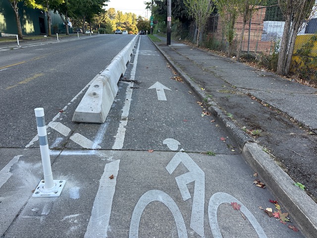
Thanks to Manuel for the photos! A reader asked us what SDOT workers were doing this weekend near 28th/Yancy, and his photos provide the answer – adding wheel-stop barriers to the bike lane installed three years ago.
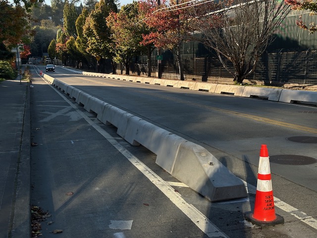
The bike lane was installed not long after the city swept a six-year, multi-block RV encampment along Andover and 28th.
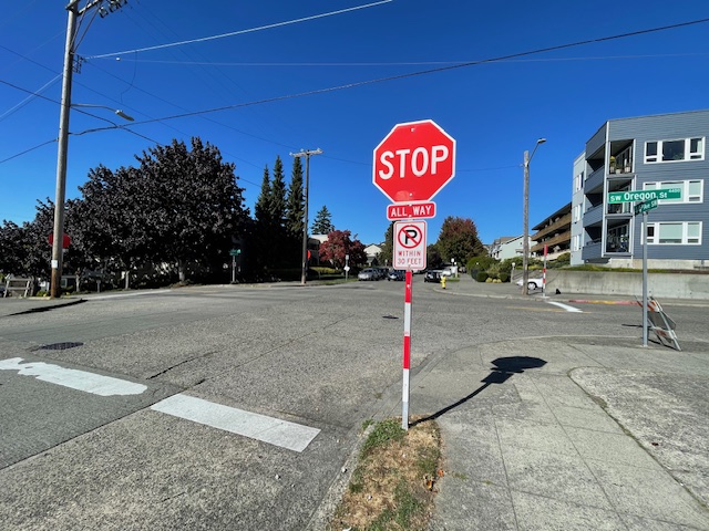
When we first reported September 24 on the all-way stop that appeared unannounced earlier that day at 44th/Oregon in The Junction, we promised to follow up with SDOT to ask what led to its installation, and if any others were on the way. Today we finally got the explanation from SDOT spokesperson Mariam Ali, who also acknowledges – as commenters had observed – that the signage was installed without accompanying alerts:
The City received strong feedback from community members concerned about pedestrian safety at this intersection, including a petition with 175 signatures in support of installing an all-way stop. After evaluating the location using our standard criteria — including traffic volumes, pedestrian activity, and proximity to the business district — it met the threshold for all-way stop control and was approved. Given the safety concerns raised and strong community support, we prioritized moving quickly once the intersection met the criteria.
The new stop signs were installed on Wednesday (9/24), and “Traffic Revision Ahead” signs were placed on Friday (9/26). We recognize the lag between installation and signage and are updating our process so that advance warning signs will be in place at the same time as new stop signs going forward.
No additional all-way stops are currently under evaluation in this area. However, SDOT welcomes community requests citywide — residents can use the City’s Find It, Fix It app or email 684-Road@seattle.gov to raise safety concerns at specific locations.
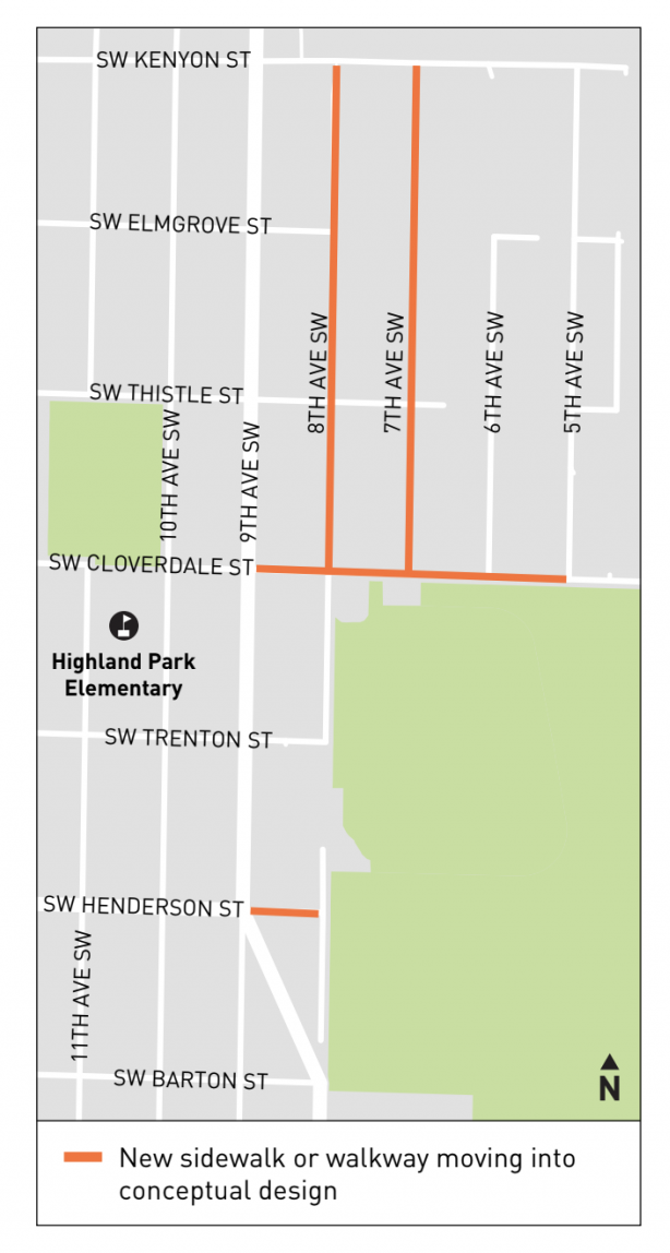
Back in May, SDOT held a walking tour in Highland Park (WSB coverage here) – one of several in West Seattle – to gather community input on where new sidewalks/walkways should be built with Seattle Transportation Levy money. Today, the department sent the results, in report format, including the map above, showing blocks that are going to “move into conceptual design.” The report explains:
In most cases, sidewalk or walkway will be designed on one side of the street. Sidewalks and walkways may be constructed from a variety of materials including paint, asphalt, concrete and barriers. Specific design treatments are decided based on factors including the space available on the street, drainage needs, existing infrastructure, impacts to parking, slopes, and estimated construction costs. Projects will be in construction between 2026 and 2029. We will be working closely with adjacent property owners as design progresses. Updates will also be provided on our project website. Project schedules will begin to be available as soon as the end of 2025.
They’re looking for feedback by next Wednesday (October 8) at LevySidewalk@seattle.gov – see the full report here.
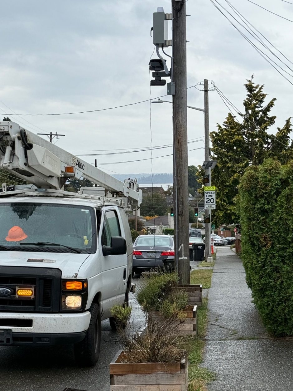
Don sent that photo Monday, after noticing installation of the new school-zone speed cameras on Admiral Way for the return next year of Alki Elementary, once its new building is complete. That led us to check in with SDOT for the status of the new school-zone speed cameras that have been scheduled to start operation this year, on California SW near West Seattle High School (not far from Lafayette Elementary, too). SDOT spokesperson Mariam Ali‘s reply revealed that they’re likely to start with the southbound direction only:
The new southbound school zone speed camera on California Ave SW near West Seattle High School has been installed and is in final testing. We expect it to be activated in the coming weeks, though the exact date is still being finalized. Once activated, the camera will issue warnings only for the first 30 days after activation, with citations beginning after that period. SDOT will share information with the community when the camera goes live. Notices will be mailed to drivers during the warning period.
A northbound camera is also planned for West Seattle High but has been delayed due to underground utility conflicts. Our engineering team is working on a solution, and we’ll share an updated installation timeline once available.
SDOT also verified that the Alki Elementary-related cameras on Admiral Way are in place (as shown above) “but will remain inactive until the new school building opens, currently expected in 2026.” Five other school zones in West Seattle have ticketing cameras, listed here. Getting a ticket from a school-zone cam could cost you more than $200.
One day after pulling the third boat from Fauntleroy-Vashon-Southworth because of a ferry breakdown elsewhere, Washington State Ferries says it expects that the Triangle Route “will be on the two-boat schedule for the next couple of weeks.” But starting this afternoon, WSF is adding back an unscheduled third boat, the 64-vehicle M/V Salish. (Check the Vessel Watch tracker to see when it’s officially on the run.)
Because of system shuffling forced by the breakdown of a ferry serving Mukilteo-Clinton, the Fauntleroy-Vashon-Southworth route is down to two boats and will officially use the two-boat schedule this afternoon. The alert from Washington State Ferries says, “The first sailings today on the two-boat schedule will be the 12:35 p.m. Vashon to Southworth on the #2 Issaquah and the 12:40 p.m. Vashon to Fauntleroy on the #1 Kittitas. ” The two-boat schedule is linked from the WSF alerts page.
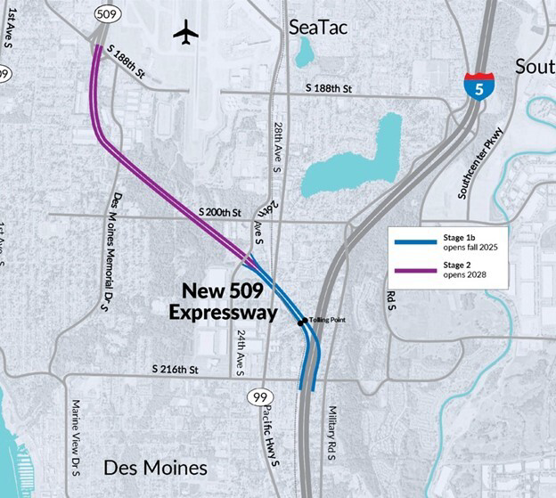
With the north stretch of State Highway 509 running past southeast West Seattle, you might be wondering what you need to know about the tolling that starts tomorrow on the newly opened southern “expressway” stretch. Jennifer emailed us after noticing what appeared to be a transponder on the Normandy Park exit, and wondered if that meant the tolling will go that far north. We took the question to WSDOT‘s Kris Olsen, who sent the map you see above, underscoring that only the green mile will be tolled starting tomorrow (and will remain the only tolled section for a few years):
Only the first mile of the new expressway is open. The first mile is between I-5 and 24th Avenue South, so that is the only portion that will be tolled right now.
The remaining 2 miles between 24th Avenue South and South 188th Street (the Normandy Park exit) won’t open until 2028 and that’s when tolling will begin in that section.
But even then, Olsen continues, the tolled section will go no further north than S. 188th:
It’s important to note that the existing sections of SR 509 (basically between the First Avenue South bridge and South 188th Street) will NOT be tolled. Starting in 2028, anyone who drives south on SR 509 must exit at South 188th Street if they do not want to pay a toll. If they continue south beyond that point, they will be tolled. The tolling gantries are located just west of the I-5 interchange.
Toll rates for the new one-mile expressway, starting tomorrow, are listed here.
 (WSB photo from South Delridge walking tour last April)
SDOT‘s been doing a series of walking tours in areas that might get a few new stretches of sidewalks/walkways because of the Seattle Transportation Levy (we’ve covered Highland Park and South Delridge tours). Now they’ve just announced a tour in one of West Seattle’s most sidewalk-less neighborhoods, Arbor Heights. Here’s the announcement:
Want to see new safe places to walk in the Arbor Heights neighborhood? Thanks to the Seattle Transportation Levy we can build at least 10 blocks of new sidewalk or walkway in Arbor Heights. Please join us for a neighborhood walk and share with us where you would like to see new walkways and/or sidewalks.
Date: Wednesday October 8, 2025
Time: 5:00-6:30 pm
Location: Meet in covered area in front of Arbor Heights Elementary School at 3701 SW 104th St and then walk the neighborhood with us!
Kids are welcome! Rain or Shine!
Here’s the official notice.
Just one week after Washington State Ferries announced a date for their fall online-only system-wide community meetings, they’ve changed it: The meetings are now set for 1 pm and 6 pm Tuesday, October 14. If you’d already registered for the original date, you’ll have to re-register for the new one; you can register for one or both (WSF promises duplicate content) right now by going here.
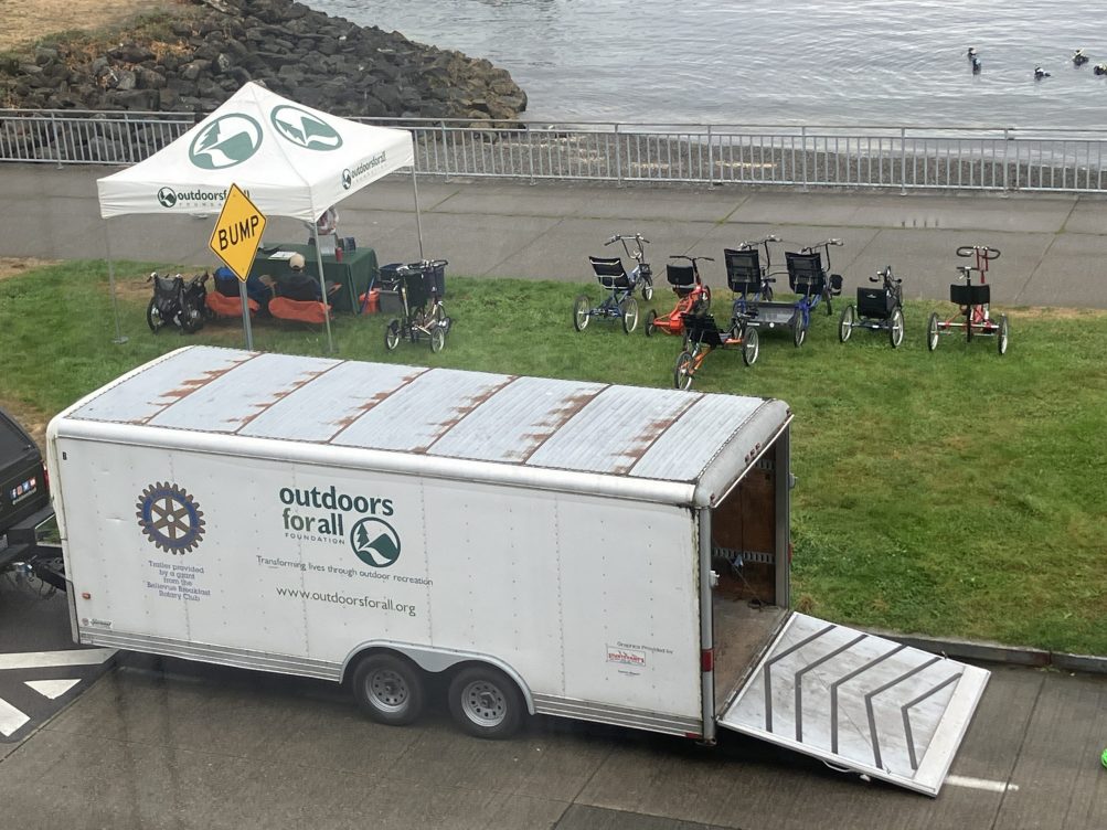
Thanks to Dave Townsend for the photo! Also happening right now, Outdoors for All is back in West Seattle with another chance to try adaptive cycling for free. They’re there until 2 pm “for folks to come out and ride the trike, tandem, or handcycle that works best for them. The event is for kids as young as 7 and adults, and there is no charge – just a short registration on-site”
Lots of hot topics for Washington State Ferries lately, including the restoration of three-boat service on the Fauntleroy-Vashon-Southworth route. Got a question? Concern? Comment? That and many other topics are up for discussion at WSF’s fall system-wide community meetings, happening online at 12:30 pm and 6 pm Thursday, October 2. WSF boss Steve Nevey says, “Each meeting will begin with a brief presentation about this summer’s increased service, our new vessel build program and recent changes here at WSF. Most of the time will be dedicated to answering questions.” You can register for one or both (WSF promises duplicate content) right now by going here.
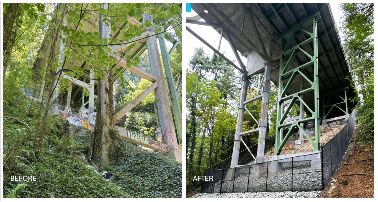
Thanks for the tip. One week after SDOT told us they expected to reopen Fairmount Avenue beneath the Admiral Way Bridge before the holiday weekend – marking the completion of most work on the project to strengthen and preserve the bridge – they’ve done just that. Above are the SDOT “before and after” photos from beneath the bridge. The project page goes into details of what they’ve done during the construction closure. Fairmount has been closed to all traffic – including bicyclists, walkers, and runners – since July of last year. The topside was originally scheduled to have some full closures during the project, but SDOT found a way to avoid that.
Today we welcome Executive Car Service as a new WSB sponsor. Here’s what they would like you to know about what they do:
Riding in Style Across Seattle — Let Executive Car Service Drive You
 Picture this: You step out of Sea-Tac Airport and are greeted by a friendly chauffeur who already knows your destination. You settle into the spotless interior of a luxury vehicle, choosing your favorite music — or enjoying peaceful silence — with a cool bottle of water within easy reach.
That’s Executive Car Service in action — making your ride as smooth as your destination. Whether you’re a frequent flyer, a business traveler, or planning a special night out, these pros have built a reputation across Seattle for punctuality, professionalism, and pure comfort.
Why They’re a Local Favorite
Ask around and you’ll hear the same name come up: Greg. He’s just one of the many highly praised drivers on the team — known for being reliable, courteous, and detail-oriented.
Customers love the little touches: spotless vehicles, help with luggage, and a seamless booking process that means no last-minute stress.
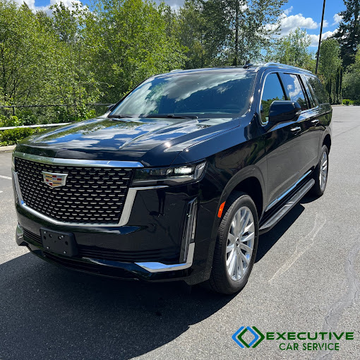
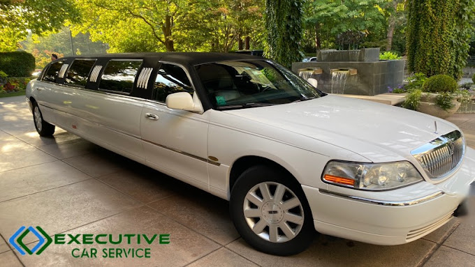
A Fleet That Fits Every Occasion
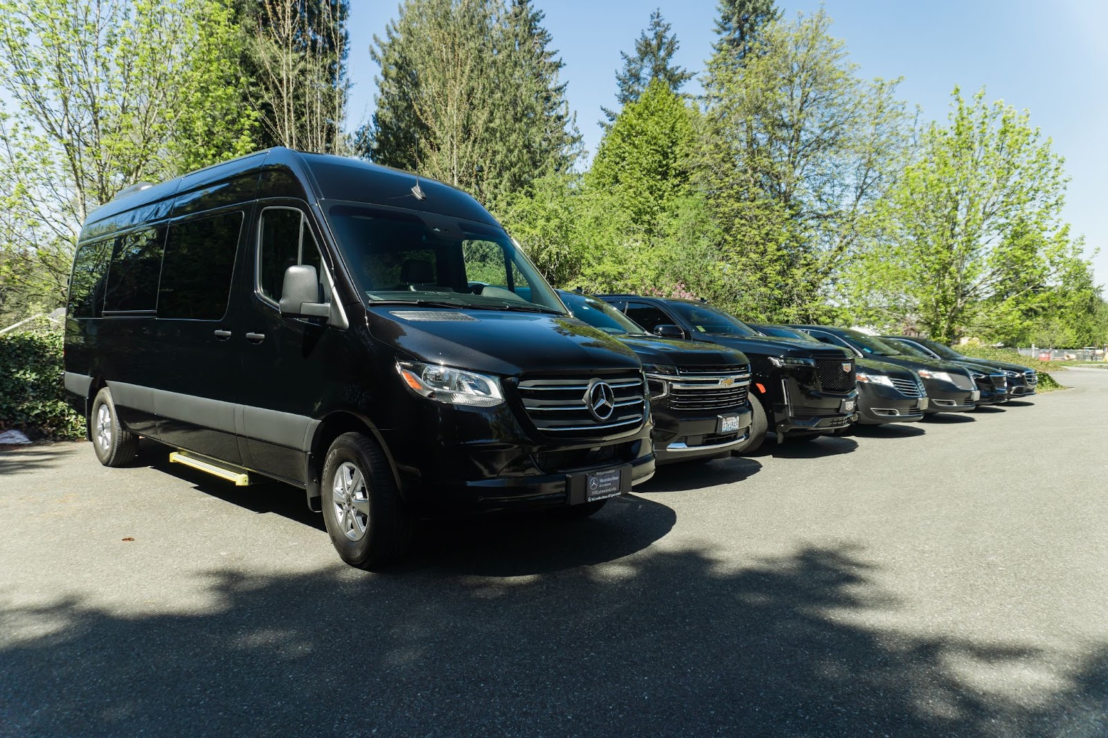
Executive Car Service offers more than just rides—they deliver experiences. Choose from:
-Elegant sedans for solo travelers or business tripsSpacious SUVs for families or group comfort
-Stretch limos for weddings, proms, or VIP events
-Sprinter vans and party buses—yes, complete with TVs, sound systems, and mini-bars—for nights out or group tours
No matter your choice, every ride comes immaculately maintained and stocked for comfort. See the full lineup here: Our Fleet
Never Late, Always Professional
Time is money—and these drivers treat yours like gold. Using real-time traffic and flight tracking, they make sure you’re on schedule every single time.
Whether it’s catching a flight, arriving for a meeting, or getting the bride to the venue, punctuality is non-negotiable.
Perfect for Any Event
Here’s where Executive Car Service really shines:
Airport Transfers — SeaTac, Paine Field, and all regional airports
Weddings & Proms — Arrive in style, stress-free
Corporate Travel — Impress clients, avoid parking hassles
Concerts & Nights Out — Focus on fun, not driving
City Tours — Discover Seattle’s gems from the back seat
Learn more about their event options: Special Occasion Transportation
Serving All of Greater Seattle: From Seattle proper to Bellevue, Redmond, Kirkland, Tacoma, Everett, Lynnwood — wherever you are, they’ve got you covered.
Ready for Your Next Ride?
Next time you need a ride that’s more than just transportation, make it Executive Car Service. Book your next journey here: executivecarservice.com
We thank Executive Car Service for choosing to advertise their business by sponsoring independent, community-collaborative neighborhood news on WSB. Interested in doing the same? Please email WSBAdvertising@wsbsales.com – thank you!
1:26 PM: A reader messaged us to report major delays on Washington State Ferries‘ Fauntleroy-Vashon-Southworth route. WSF has made two announcements of situations likely factoring into this. Biggest is that the route is down one boat, and as a result, one terminal:
#1 Kittitas Out of Service Due to Crewing – Southworth Travel Out of Service
The #1 Kittitas is out of service until further notice, due to crewing. A relief worker is required before we can move the vessel. Southworth travel is out of service until further notice.
Second, there’s paving work at the Vashon terminal parking lot, and that’s affecting the usage of holding lanes, with WSF warning Vashon travelers to “allow extra time for travel.”
P.S. Vessel Watch shows Kittitas is tied up at Southworth, which is a one-slip terminal, so that explains why it’s completely out of service. We’re checking with WSF to see if they have any kind of ETA for finding the needed worker.
1:44 PM: Though the WSF alerts webpage isn’t updated yet, Vessel Watch shows Kittitas has left Southworth and is now sailing again.
1:51 PM: The reader who first tipped us about all this says WSF workers reported Kittitas left Southworth with foot passengers only. Bottom line, if you need to use the Triangle Route ferry/ies, be aware the schedule is currently out the window.
2:03 PM: WSF’s official update: “The #1 Kittitas will return to service at approximately 2:25 p.m.”
 (WSB photo, July 2024)
Quick update from SDOT on the Admiral Way Bridges work, one week after our previous update – spokesperson Mariam Ali messaged us this morning to say, “Just wanted to give you a heads up that we should be mostly done with this project by Labor Day.” Does that include Fairmount Avenue reopening beneath the bridge? She said yes. As our photo above shows, the original projection for that reopening was six months ago; SDOT says scope expansion, such as added painting, stretched out the timeline for the project.
 (WSF photo)
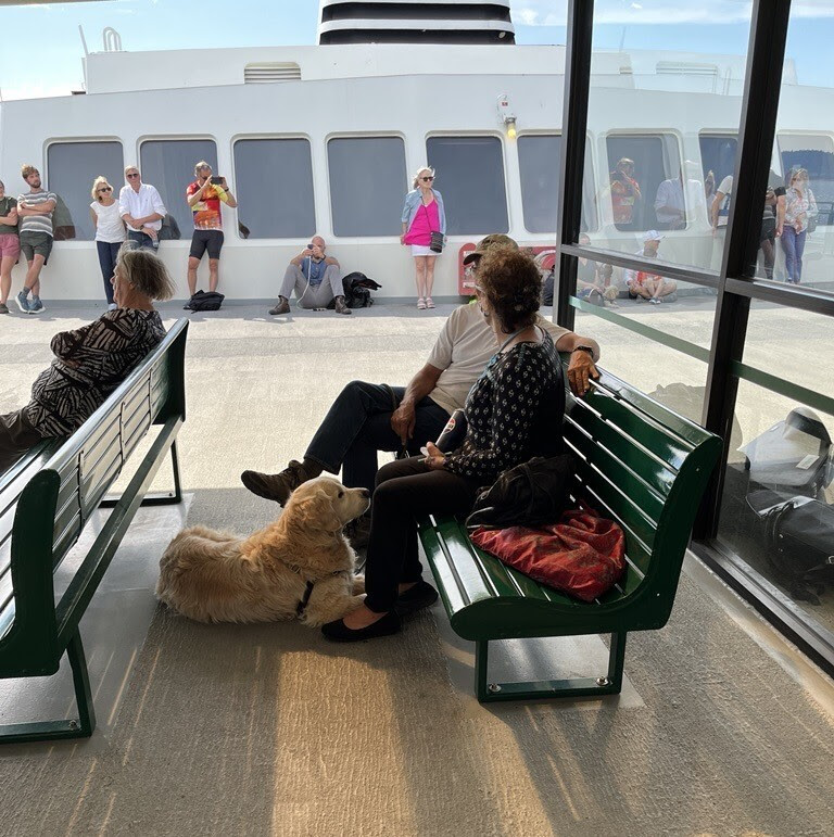
Announced in Washington State Ferries‘ weekly newsletter, as well as a rider alert, WSF is testing a new policy of allowing dogs in more places on its boats. In the newsletter, WSF second-in-command John Vezina wrote:
Steve [Nevey] and I are happy to share news about dogs on our ferries. Based on feedback from customers and employees, and to align with partner transit agencies, we began a six-month trial of an updated pet policy yesterday. During this trial, dogs on leashes are allowed in all passenger areas, except galleys. All other pets must stay in a crate or carrier. Big dogs should stay on the floor. Small dogs should be on a lap or in a carrier. Owners must control their pets and clean up after them. Crew members may direct pets to be moved to an outside deck or vehicle if needed for safety or behavior reasons. As always, service animals are welcome everywhere, as required by law. Livestock must stay in appropriate enclosures at all times. This trial will help us decide if the new rules should become permanent. Your feedback is welcome.
Here are ways to provide feedback to WSF. You can read more about the WSF policy here.
 (SDOT camera image, Wednesday)
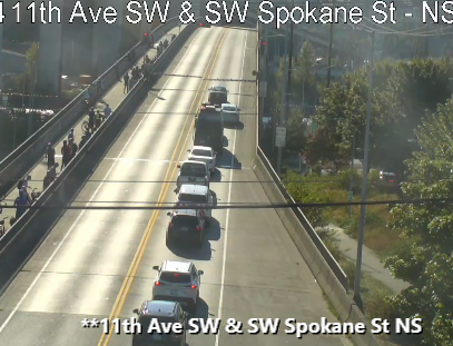
As reported here, the West Seattle low bridge was closed to surface traffic for about four hours on Wednesday. It already was scheduled to be out of service this coming weekend for repairs; we asked SDOT today what went wrong yesterday and whether that will affect the weekend plan. Here’s how spokesperson Mariam Ali explained it:
Yesterday, a driver attempted to maneuver around a closed gate, which led to a circuit breaker being tripped and temporarily affecting the gate system. The issue was quickly resolved, the Coast Guard was notified, and electricians are completing final repairs today. There will be no impact on work scheduled for this weekend, and bridge operations are proceeding normally.
This weekend’s closure is set to start at 7 am Saturday and could last as late as 10 pm Sunday.
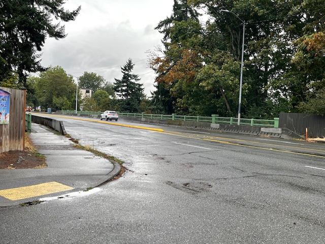
No cones, no crews. The top side of the Admiral Way Bridge (technically two bridges) is clear again. So does that mean the earthquake-resistance work is finally done? No, SDOT tells us:
It’s too soon to say whether work is done in that area. We’re close to wrapping up the project but it remains an active work zone, and conditions change periodically. We still have work scheduled through the end of the month and there will most likely be final punch list items to work on in the following months.
It’s been a year now since the top-side work began; Fairmount Avenue beneath the bridge(s) has been closed even longer and will remain that way until the project is done. Originally, the project was expected to require full closures of the bridge, but SDOT amended the plan to avoid that.
 (WSDOT image)
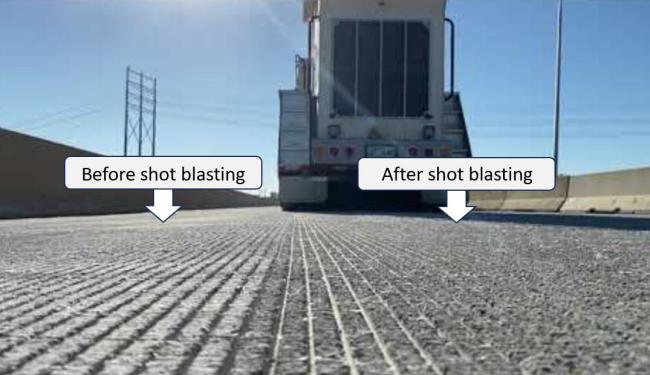
The late-summer revving up of road work continues. Today’s announcement: Six and a half years after its opening, the Highway 99 tunnel needs traction improvement, so overnight closures are ahead. Here’s what WSDOT has announced:
It’s about time for people who use the State Route 99 tunnel under downtown Seattle to get a grip.
Beginning Monday night, Aug. 18, contractor crews working for the Washington State Department of Transportation will texturize lanes in the tunnels to improve traction for vehicles.
The quick-moving project requires up to five nightly closures in each the northbound and southbound tunnels. Work is expected to wrap up before Labor Day weekend.
Since the tunnel opened in February 2019, the driving surface of the 2-mile, double-decker tunnel has become worn. More than 47,000 vehicles used the tunnels daily in 2023.
The $1.5 million project will restore the tire grip the northbound and southbound tunnels had when they opened more than six years ago.
A technique called shot-blasting will rehabilitate the driving surface, using high-velocity particle grains. This blasting will change the roadway’s coarseness. Trucks will tow machines that blast the grains and vacuum any dust created from the process so that the tunnels’ air filtration systems and storm drains will not clog.
What to expect
Work begins with all northbound SR 99 lanes closing Monday night, Aug. 18. From 11 p.m. to 4:30 a.m. nightly for up to five nights, all northbound SR 99 traffic will need to exit to South Dearborn Street. The Colorado Avenue South on-ramp to northbound SR 99 will close an hour earlier each night at 10 p.m.
Once crews finish texturing northbound lanes, they will switch and close the southbound tunnel for up to five nights. From 10 p.m. to 5 a.m. nightly, all southbound SR 99 traffic must exit at the Denny Way off-ramp. The Sixth Avenue South on-ramp to southbound SR 99 will close at the same time.
Signed detours will guide people around the tunnel closures using city streets and northbound and southbound Interstate 5. Nightly closures will not begin until two hours after the last pitch for Seattle Mariners games at T-Mobile Park or completion of Seattle Reign and Sounders games at Lumen Field.
You can read more about the work here.
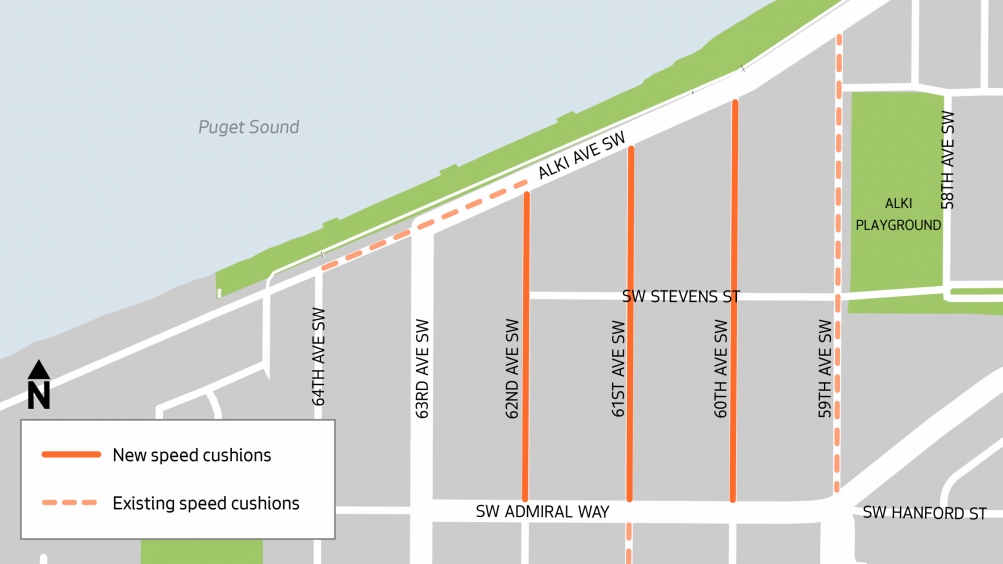
When we reported a month ago on SDOT‘s plans for speed cushions on 60th, 61st, and 62nd SW in the Alki area, the SDOT announcement was fairly vague – no locations and no timeline aside from “summer” (which still has almost six weeks to left). This week, a notice about the impending work arrived in nearby residents’ postal mailboxes, according to one reader. So we asked SDOT for the notice, since it’s of interest to more than those who live on or near the affected streets. They pointed us to this webpage, which includes the map above as well as these details of the planned locations:
60th Ave SW from SW Admiral Way to Alki Ave SW
61st Ave SW from SW Admiral Way to Alki Ave SW
62nd Ave SW from SW Admiral Way to Alki Ave SW
The same info is published here in multilingual fact-sheet format. Both online and via email, SDOT says the main warning that’ll be provided to neighbors is “no parking” signs arriving at least three days in advance in the installation spots.
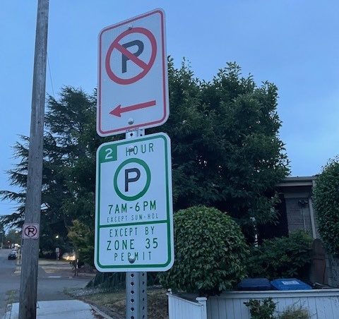
Six years have passed since SDOT created a Restricted Parking Zone (RPZ) in The Junction, after two community requests in the span of a decade. Its boundaries have expanded a few times. But that usually comes with an announcement and/or outreach. Not this time. A reader sent us the photo above and the observation/question:
New restricted (2-hour) parking zone signs are being installed along the west side of Glenn Way north of Oregon. Is this occurring elsewhere around the Junction’s existing RPZ limits? No public notice or community outreach by SDOT?
RPZ residents pay $95 for a two-year permit ($10 if they meet income requirements), which does not guarantee parking in the zone, only the right to not be subject to the restrictions. We asked SDOT about the new expansion, and received this reply:
SDOT recently installed these signs as part of a small, one-block expansion of the existing RPZ in that area.
This change was made in response to a request from the two households directly adjacent to that block, who had been experiencing issues with all-day commuter parking. Because their homes are located right next to the current RPZ, we were able to extend the zone to their side of the street in alignment with the goals of the program.
We didn’t send out broader notices for this particular change because it was such a limited expansion and came directly from the residents most affected — in this case, the same two households who are now covered by the new signage.
This isn’t the first time the Junction RPZ has expanded at residents’ request; less than a year after its inception, in 2020, we reported on the addition of several blocks whose residents petitioned the city. We also reported – again, thanks to a reader tip – on a one-block expansion last year. SDOT’s process for expanding or creating RPZs is explained here; existing RPZs are mapped here. (Besides the one in and around The Junction, West Seattle has one other RPZ, near the Fauntleroy ferry dock.)
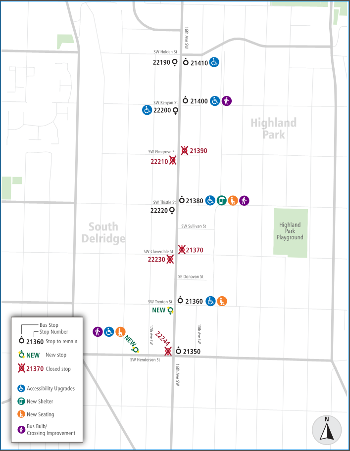
A year and a half after we first reported on proposed Metro bus-stop changes in Highland Park – seemingly proceeding at the time with little notice or feedback opportunities – the final plan is out. It looks much different from the original plan, though it still includes bus-stop closures. Here’s what we received today from Metro:
Bus stop upgrades on routes 125 and 128 in West Seattle are heading for construction this summer as part of an effort to improve transit conditions along 16th Avenue SW between SW Holden and Henderson streets.
Metro collected feedback from riders and neighbors in 2024 and developed proposed changes to be built by the City of Seattle that reflect rider and community requests. The plan moving forward is to make improvements at five existing bus stops and two new stops.
The improvements include bus boarding zones that are accessible for individuals who use mobility devices, seating and shelter for transit riders, and bus bulbs designed to enhance transit service and reduce pedestrian crossing distances at intersections.
Four current bus stops located at SW Elmgrove and Cloverdale streets will be closed once nearby bus stop upgrades are completed and riders would be directed about one block away to new or improved bus stops.
Location improvements on 16th Avenue SW and SW Henderson Street:
SW Holden Street
Stop No. 21410 (northbound): Accessibility improvements for people with disabilities.
SW Kenyon Street
Stop No. 21400 (northbound): Wider sidewalk “bus bulb” for easier crossing and accessibility improvements for people with disabilities.
Stop No. 22000 (southbound): Accessibility improvements for people with disabilities.SW Thistle Street
Stop No. 21380 (northbound): New bus shelter, new seating, wider sidewalk “bus bulb” for easier crossing and accessibility improvements for people with disabilities.
SW Trenton Street
Stop No. 21360 (northbound): New seating and accessibility improvements for people with disabilities.
Southbound: New bus stop location.Southwest Henderson Street
Westbound: New bus stop location with seating, wider sidewalk “bus bulb” for easier crossing and accessibility improvements for people with disabilities.
Questions about Metro’s plans can be emailed to community.relations@kingcounty.gov and questions about construction plans can be emailed to Aidan Bernal at the Seattle Department of Transportation, aidan.bernal@seattle.gov.
We’ll be following up with SDOT regarding construction timeline.
P.S. Thanks again to Juan for the original tip last year!
 (File photo)
Metro has announced both its next “service change” plan for buses and a round of fare changes for bus and Water Taxi service – almost all increases. Here’s how West Seattle service will be affected:
AUGUST 30 SERVICE CHANGE: Metro’s twice-yearly list of changes to various routes is out, and this time, no West Seattle routes are on the list – no service additions or subtractions in this area.
BUS AND WATER-TAXI FARE CHANGES, MOSTLY INCREASES: Two days later, on Monday, September 1, fare changes kick in for Metro bus and Water Taxi service. You can see the full table here. Key changes:
Full fares
*Metro bus/Flex adult fares rise 25 cents to $3
*West Seattle Water Taxi adult fares rise 50 cents to $6.25
ORCA fares
*West Seattle Water Taxi, up 25 cents to $5.25
*West Seattle Water Taxi ORCA LIFT, down $2.75 to $1
Metro notes that the 25-cent increase in full adult bus fares will be the first one since it established flat fares in 2018.
P.S. In case you’re wondering, October 10 is the end of this year’s “summer schedule” for the West Seattle Water Taxi, which means regular Friday and Saturday later-night service will end then, until spring.
| 17 COMMENTS