West Seattle, Washington
11 Saturday
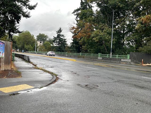
No cones, no crews. The top side of the Admiral Way Bridge (technically two bridges) is clear again. So does that mean the earthquake-resistance work is finally done? No, SDOT tells us:
It’s too soon to say whether work is done in that area. We’re close to wrapping up the project but it remains an active work zone, and conditions change periodically. We still have work scheduled through the end of the month and there will most likely be final punch list items to work on in the following months.
It’s been a year now since the top-side work began; Fairmount Avenue beneath the bridge(s) has been closed even longer and will remain that way until the project is done. Originally, the project was expected to require full closures of the bridge, but SDOT amended the plan to avoid that.
 (WSDOT image)
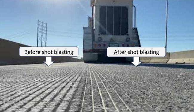
The late-summer revving up of road work continues. Today’s announcement: Six and a half years after its opening, the Highway 99 tunnel needs traction improvement, so overnight closures are ahead. Here’s what WSDOT has announced:
It’s about time for people who use the State Route 99 tunnel under downtown Seattle to get a grip.
Beginning Monday night, Aug. 18, contractor crews working for the Washington State Department of Transportation will texturize lanes in the tunnels to improve traction for vehicles.
The quick-moving project requires up to five nightly closures in each the northbound and southbound tunnels. Work is expected to wrap up before Labor Day weekend.
Since the tunnel opened in February 2019, the driving surface of the 2-mile, double-decker tunnel has become worn. More than 47,000 vehicles used the tunnels daily in 2023.
The $1.5 million project will restore the tire grip the northbound and southbound tunnels had when they opened more than six years ago.
A technique called shot-blasting will rehabilitate the driving surface, using high-velocity particle grains. This blasting will change the roadway’s coarseness. Trucks will tow machines that blast the grains and vacuum any dust created from the process so that the tunnels’ air filtration systems and storm drains will not clog.
What to expect
Work begins with all northbound SR 99 lanes closing Monday night, Aug. 18. From 11 p.m. to 4:30 a.m. nightly for up to five nights, all northbound SR 99 traffic will need to exit to South Dearborn Street. The Colorado Avenue South on-ramp to northbound SR 99 will close an hour earlier each night at 10 p.m.
Once crews finish texturing northbound lanes, they will switch and close the southbound tunnel for up to five nights. From 10 p.m. to 5 a.m. nightly, all southbound SR 99 traffic must exit at the Denny Way off-ramp. The Sixth Avenue South on-ramp to southbound SR 99 will close at the same time.
Signed detours will guide people around the tunnel closures using city streets and northbound and southbound Interstate 5. Nightly closures will not begin until two hours after the last pitch for Seattle Mariners games at T-Mobile Park or completion of Seattle Reign and Sounders games at Lumen Field.
You can read more about the work here.
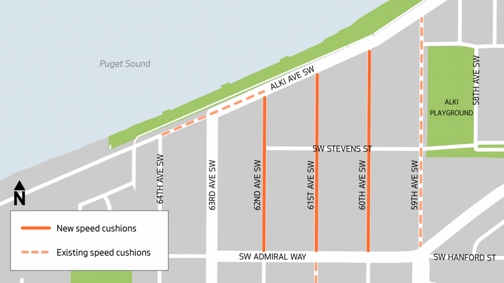
When we reported a month ago on SDOT‘s plans for speed cushions on 60th, 61st, and 62nd SW in the Alki area, the SDOT announcement was fairly vague – no locations and no timeline aside from “summer” (which still has almost six weeks to left). This week, a notice about the impending work arrived in nearby residents’ postal mailboxes, according to one reader. So we asked SDOT for the notice, since it’s of interest to more than those who live on or near the affected streets. They pointed us to this webpage, which includes the map above as well as these details of the planned locations:
60th Ave SW from SW Admiral Way to Alki Ave SW
61st Ave SW from SW Admiral Way to Alki Ave SW
62nd Ave SW from SW Admiral Way to Alki Ave SW
The same info is published here in multilingual fact-sheet format. Both online and via email, SDOT says the main warning that’ll be provided to neighbors is “no parking” signs arriving at least three days in advance in the installation spots.
Six years have passed since SDOT created a Restricted Parking Zone (RPZ) in The Junction, after two community requests in the span of a decade. Its boundaries have expanded a few times. But that usually comes with an announcement and/or outreach. Not this time. A reader sent us the photo above and the observation/question:
New restricted (2-hour) parking zone signs are being installed along the west side of Glenn Way north of Oregon. Is this occurring elsewhere around the Junction’s existing RPZ limits? No public notice or community outreach by SDOT?
RPZ residents pay $95 for a two-year permit ($10 if they meet income requirements), which does not guarantee parking in the zone, only the right to not be subject to the restrictions. We asked SDOT about the new expansion, and received this reply:
SDOT recently installed these signs as part of a small, one-block expansion of the existing RPZ in that area.
This change was made in response to a request from the two households directly adjacent to that block, who had been experiencing issues with all-day commuter parking. Because their homes are located right next to the current RPZ, we were able to extend the zone to their side of the street in alignment with the goals of the program.
We didn’t send out broader notices for this particular change because it was such a limited expansion and came directly from the residents most affected — in this case, the same two households who are now covered by the new signage.
This isn’t the first time the Junction RPZ has expanded at residents’ request; less than a year after its inception, in 2020, we reported on the addition of several blocks whose residents petitioned the city. We also reported – again, thanks to a reader tip – on a one-block expansion last year. SDOT’s process for expanding or creating RPZs is explained here; existing RPZs are mapped here. (Besides the one in and around The Junction, West Seattle has one other RPZ, near the Fauntleroy ferry dock.)
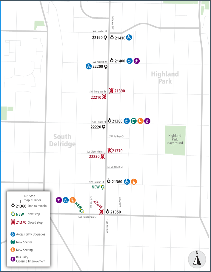
A year and a half after we first reported on proposed Metro bus-stop changes in Highland Park – seemingly proceeding at the time with little notice or feedback opportunities – the final plan is out. It looks much different from the original plan, though it still includes bus-stop closures. Here’s what we received today from Metro:
Bus stop upgrades on routes 125 and 128 in West Seattle are heading for construction this summer as part of an effort to improve transit conditions along 16th Avenue SW between SW Holden and Henderson streets.
Metro collected feedback from riders and neighbors in 2024 and developed proposed changes to be built by the City of Seattle that reflect rider and community requests. The plan moving forward is to make improvements at five existing bus stops and two new stops.
The improvements include bus boarding zones that are accessible for individuals who use mobility devices, seating and shelter for transit riders, and bus bulbs designed to enhance transit service and reduce pedestrian crossing distances at intersections.
Four current bus stops located at SW Elmgrove and Cloverdale streets will be closed once nearby bus stop upgrades are completed and riders would be directed about one block away to new or improved bus stops.
Location improvements on 16th Avenue SW and SW Henderson Street:
SW Holden Street
Stop No. 21410 (northbound): Accessibility improvements for people with disabilities.
SW Kenyon Street
Stop No. 21400 (northbound): Wider sidewalk “bus bulb” for easier crossing and accessibility improvements for people with disabilities.
Stop No. 22000 (southbound): Accessibility improvements for people with disabilities.SW Thistle Street
Stop No. 21380 (northbound): New bus shelter, new seating, wider sidewalk “bus bulb” for easier crossing and accessibility improvements for people with disabilities.
SW Trenton Street
Stop No. 21360 (northbound): New seating and accessibility improvements for people with disabilities.
Southbound: New bus stop location.Southwest Henderson Street
Westbound: New bus stop location with seating, wider sidewalk “bus bulb” for easier crossing and accessibility improvements for people with disabilities.
Questions about Metro’s plans can be emailed to community.relations@kingcounty.gov and questions about construction plans can be emailed to Aidan Bernal at the Seattle Department of Transportation, aidan.bernal@seattle.gov.
We’ll be following up with SDOT regarding construction timeline.
P.S. Thanks again to Juan for the original tip last year!
 (File photo)
Metro has announced both its next “service change” plan for buses and a round of fare changes for bus and Water Taxi service – almost all increases. Here’s how West Seattle service will be affected:
AUGUST 30 SERVICE CHANGE: Metro’s twice-yearly list of changes to various routes is out, and this time, no West Seattle routes are on the list – no service additions or subtractions in this area.
BUS AND WATER-TAXI FARE CHANGES, MOSTLY INCREASES: Two days later, on Monday, September 1, fare changes kick in for Metro bus and Water Taxi service. You can see the full table here. Key changes:
Full fares
*Metro bus/Flex adult fares rise 25 cents to $3
*West Seattle Water Taxi adult fares rise 50 cents to $6.25
ORCA fares
*West Seattle Water Taxi, up 25 cents to $5.25
*West Seattle Water Taxi ORCA LIFT, down $2.75 to $1
Metro notes that the 25-cent increase in full adult bus fares will be the first one since it established flat fares in 2018.
P.S. In case you’re wondering, October 10 is the end of this year’s “summer schedule” for the West Seattle Water Taxi, which means regular Friday and Saturday later-night service will end then, until spring.
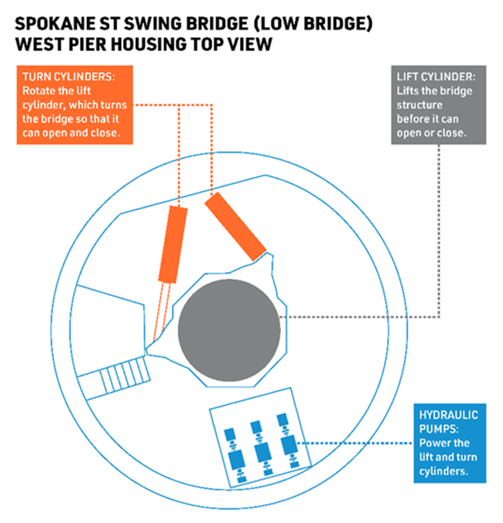
The next low-bridge closure is set for the weekend of Saturday-Sunday, August 23-24. Here’s the announcement from SDOT:
The Spokane St Swing Bridge, commonly known as the low bridge, was built in 1991 and serves as a crucial link across the West Duwamish Waterway, especially for people walking, rolling, and biking. To keep the bridge reliably operating, starting August 23 and continuing through August 24, the low bridge will be closed for people driving, biking, rolling, and walking for about two days. During this time, crews will be repairing a part called a “manifold” on the turn cylinder that was installed in June. This turn cylinder manifold controls the flow of fluids within the turn cylinder, which helps manage how fast the bridge moves.
Work on this project, which includes other ongoing maintenance, is expected to continue throughout 2025.
Over the next year, additional short-term closures will be required as part of our ongoing preventative maintenance work on this bridge. That means that in the future, the low bridge will be closed again to people walking, biking, rolling, and driving.
We’ll be asking SDOT a few followup questions, including what time on August 23 the closure is expected to start.
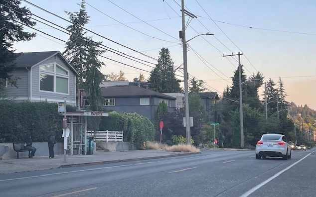
We’re continuing our reports on major updates from this week’s Morgan Community Association meeting. On Thursday we updated the Morgan Junction EV charging lot plan; today, the Fauntleroy/Rose crossing (which has been a focus for the neighboring Fauntleroy Community Association too).
 (Southward view from the ferry-queue lane on the Lincoln Park side of Fauntleroy Way)
The intersection with Lincoln Park on the west side and a RapidRide C Line stop on the east side used to have a marked crosswalk; we briefly noted its removal in this 2007 report. Community advocates have long lobbied to get it back. And they were repeatedly told (here’s a 2021 example) by SDOT that it wouldn’t happen.
But finally the city relented (as announced in early 2024), and has been working on a plan. SDOT’s Ching Chan attended Wednesday’s MoCA meeting remotely to present an update on the design, which is more than a crosswalk – it will include pushbutton-activated lighting and a raised median to provide “a safe refuge” for pedestrians. The median will not be between north and south travel lanes, but rather between the ferry-queue lane and the travel lanes:
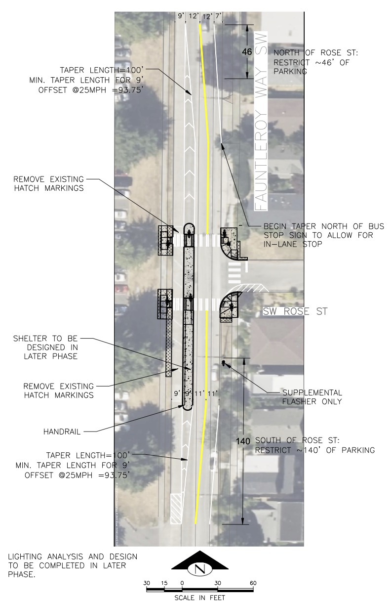 (SDOT-provided renderings above and below; see PDF versions here)
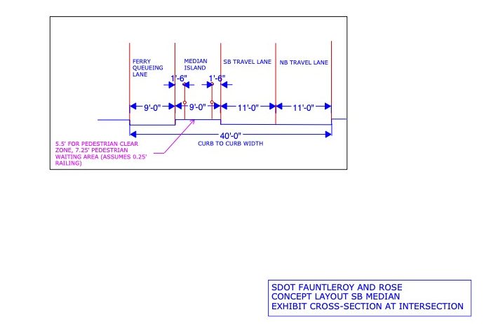
This will narrow vehicle travel lanes a bit, from 12 feet wide to 11 feet wide. It will also expand parking restrictions – about 26′ north of Rose, 140′ south, Chan said.
Concerns surfaced during the meeting included ensuring that any vegetation in the median wouldn’t become overgrown like Delridge Way and Harbor Avenue meetings, as well as whether SDOT is collaborating with WSDOT on traffic-flow effects, given the project planned later this year to signalize the Fauntleroy Way intersection at the ferry dock’s entrance/exit (Chan did not know). As for the timeline, Chan said they hope to build this by summer 2026, but the bus shelter requires collaboration with Metro, so that may have a timeline of its own.
NEXT REPORT: MoCA’s meeting also included guests from Seattle Parks to discuss the status of the Morgan Junction Park addition, which has stalled because of internal city issues regarding the removal of soil contaminated in the site’s past; we’ll have that story later today/tonight.
 (WSB photo, last month)
You might remember the uproar when SDOT announced in May that not only would it convert the Duwamish Head angled parking to parallel parking, it would likely add more than 100 new parallel spaces in the 1200 to 1700 blocks of Alki Avenue SW. At first SDOT attributed the proposed addition to City Councilmember Rob Saka – whose budget action last year set aside $175,000 for the angled-parking-to-parallel conversion as well as “to restore parallel-only parking to Alki Avenue SW adjacent to (the Duwamish Head) location” – but he then said he was not in favor of “restoring” that parking. SDOT proceeded with a survey and promised a final decision after that. The final decision is in today, and it’s “no additional parking.” The survey results were part of today’s announcement; SDOT says it received 882 responses, and since it wasn’t a yes/no survey, its summary does not have a count, but ultimately concludes that more people were against the parking expansion:
The West Seattle Parking Adjustments Survey results reveal a divided consensus among participants regarding the addition of parking to the water side of Alki Ave SW. A significant portion of respondents expressed concerns about the potential environmental impact and aesthetic disruption, emphasizing the need to preserve Alki’s natural beauty and pedestrian-friendliness. On the other hand, many saw the lack of parking as a hindrance to accessibility, particularly for visitors and families, which could negatively affect local businesses dependent on tourism and foot traffic. Overall, there were valid arguments on both sides, with more people opposing.
Bottom line, says SDOT, with that decision, that particular project is complete: “The proviso directing SDOT’s existing budget to implement changes is limited to parking adjustments, so nothing further is planned at this time.” (We’ll be asking them how much of the $175,000 remains, if it was supposed to go toward parking restoration too, and what it’ll go toward instead.)
 (WSB photo, Tuesday)
After tips about the speed cushions that have just been installed on 16th Avenue SW in the Cloverdale/Trenton vicinity, we sent inquiries to SDOT regarding why, and regarding what else is ahead, there and anywhere else in West Seattle, for “traffic-calming.” We received a detailed reply, first about the 16th SW additions:
(About the newly installed speed cushions), those will be part of a Safe Routes to School project, and will include 3 speed cushions near Highland Park Elementary School on 16th Ave SW between SW Sullivan St and SW Henderson St.
The project also includes repainting the parking-edge line to narrow travel lanes to 11 feet on 16th Ave SW between SW Holden St and SW Henderson St. Narrowing lanes in combination with the speed cushions should slow down driver speeds and make 16th more comfortable to cross.
You can expect to see 5 more speed cushions on 16th Ave SW as part of the Vision Zero street-calming project between SW Brandon St to SW Roxbury St. That includes:
-4 new speed cushions north of SW Holly St
-1 speed cushion south of SW Othello StThat project also includes safety enhancements to improve visibility for drivers, cyclists, and pedestrians at 12 intersections on 16th Ave SW (between SW Findlay St and SW Cambridge St), as well as centerline raised pavement markers (between SW Brandon St and SW Roxbury St).
So that’s what’s ahead for 16th SW. As for the rest of West Seattle:
Additional speed cushions coming to West Seattle:
*On SW Trenton St between 35th Ave SW to Delridge Way SW.
*On 62nd, 61st and 60th Aves SW in Alki.
Some of those streets already have speed cushions, so we’re pursuing details on exact locations. Last but not least, from SDOT’s reply:
Additional Safe Routes to School projects that we expect to build this year in West Seattle include:
–Madison Middle School – push button crossing beacon (i.e., RRFB) at California/Hinds and California/Spokane and intersection daylighting (paint/post bulbs that make people crossing easier to see) to improve the Madison School Street crossings [45th SW in front of the school]
–Pathfinder K-8 – curb ramps adjacent to the school at 19th Ave SW and SW Genesee St
-West Seattle Elementary – All-way stops adjacent to the school
SDOT’s reply also mentioned one school-safety project for Concord International Elementary in South Park, “curb bulbs adjacent to the school (on 7th/Henderson and 8th/Henderson) and a separate walkway with trees on S Henderson St between 12th and 14th Ave S (currently under construction).
We have a standing request with SDOT for the construction notices on projects like all of these, typically just sent to neighbors in the immediate area but often of interest far beyond; we don’t always get them, so your collaboration is appreciated – let us know if you get a notice and/or see pre-construction markings!

If you travel 16th SW in the Cloverdale-to-Trenton vicinity, you’ll note the new speed cushions are now in place. One of them is close to the site of Sunday night’s 16th/Sullivan crash, but the installation already was planned (we’ve been trying to get official info from SDOT since a reader tip last Thursday) before that. Our photo is from a short time ago; WSB contributor Anne Higuera notes the crew was just packing up when she stopped for the photo. Our questions for SDOT include whether anywhere else in West Seattle is getting new speed cushions any time soon; we’ll add anything we find out. Meantime, if you see the telltale rectangular markings on your street, and/or get a notice, please let us know, as in most cases people need to know beyond those who live/work nearby.
(‘Live’ camera image from Fauntleroy dock)
M/V Issaquah is already moored on Vashon Island, ready to take its position as the #3 boat on the Fauntleroy-Vashon-Southworth ferry run Monday morning, as Washington State Ferries officially restores three-boat service to the “Triangle Route.” It’s been a two-boat route for almost four years, and wasn’t expected to get a third boat now, until Gov. Bob Ferguson ordered WSF to pause its hybrid-electric conversion process, keeping a boat in service that otherwise would have dropped out. WSF announced in mid-April that June 30th would be the Triangle Route restoration date. But it also cautions, “There may be times when the route will shift back to two-boat service. Thanks to feedback from a community working group, Washington State Ferries has a new, updated two-boat schedule (use the drop-down menu at the top to view the other two segments of the route). This backup schedule will be used when the route loses a vessel. More information on these unplanned service disruptions can be found in WSF’s Service Contingency Plan.” There’ll be reduced capacity for a while later this summer, too, as we reported Thursday; WSF spokesperson Justin Fujioka told WSB that “Sealth is scheduled to replace Cathlamet for about a month starting in mid-August so Cathlamet can go in for some scheduled maintenance.” (Sealth is a 90-car boat, compared to the 124-car capacity Cathlamet.) The three-boat schedule, meantime, starts in the 4 am hour Monday morning.

Six and a half years after West Seattle muralist Desmond Hansen painted karate master Chojun Miyagi on the signal box at the northwest corner of 35th/Roxbury, a driver has taken it out. The hit-run happened overnight and we have few details except that the driver took out the signal box, and that left the intersection signal in flashing mode for many hours. Our photo is from late morning; we went by again a little while ago and a replacement signal box was in place. Archived radio from overnight suggests the hit-run car might have been found nearby but we won’t be able to follow up until Monday.
 (WSB photo of bridge’s topside, last night)
Earlier this week, a reader pointed out that the crudely lettered/numbered “road closed” sign at the north end of Fairmount Avenue had been amended again to show 8/28 as the projected end date of the closure. Has the Admiral Way Bridge project been delayed again? they wondered. We asked SDOT; a spokesperson confirmed their crews changed the sign, but said that’s just in what they’ve been saying for some months now, that the project will be complete “this summer”:
Yes, I can confirm that the sign is ours. The project is expected to be completed this summer. Closures under the bridge remain in place to keep everyone safe while work continues both on the bridge deck and underneath.
Right now, crews are repairing sections of cracked or broken concrete under the bridge. We’ve also started the final phase of the project by working on the bridge’s railing updates.
We understand closures can be inconvenient and appreciate everyone’s patience as we work to reinforce the bridges to better withstand the potential impacts of earthquakes.
It’s been almost exactly a year since work began (here’s our update from this date last year). It wasn’t supposed to last its long, but SDOT says adding painting to the project scope stretched the timeline.
(‘Live’ camera image from Fauntleroy dock)
In four days, Washington State Ferries plans to restore the Fauntleroy-Vashon-Southworth route to a full three-boat schedule, after years of reduced service. We asked WSF spokesperson Justin Fujioka exactly how the transition will be made. First, the boats – all three will be Issaquah class for starters, optimal for the schedule: “Issaquah is scheduled to replace Salish this weekend so Salish can go up to Port Townsend and prepare to enter service as that route’s second boat on July 4. We are planning to have that boat, plus Kittitas and Cathlamet, for most of our summer sailing season. The one exception is, Sealth is scheduled to replace Cathlamet for about a month starting in mid-August so Cathlamet can go in for some scheduled maintenance.” M/V Issaquah’s capacity – 124 cars – is almost double that of M/V Salish (which has been the “bonus boat” on the run for a while now), 64 cars. We also asked when the schedule change would take effect: “The new three-boat schedule will begin with the start of the sailing day on Monday, June 30. We will operate the entire sailing day Sunday, June 29, on the current two-boat weekend schedule, even departures after midnight.” Fujioka says that while they had some hoopla for the recent Bremerton service restoration, including a media event featuring the governor, that will NOT be happening for this restoration – WSF will just send out a reminder on Friday, including “details about the new updated backup two-boat schedule.” Comments about that schedule were requested back in April, as we reported with first word of the three-boat-service-restoration date.
 (WSB photo, June 2024)
Before we get to today’s event list, we wanted to mention one of this weekend’s unique happenings: For the third consecutive summer, Outdoors for All is bringing adaptive-cycling alternatives to West Seattle. Different location this time – Don Armeni Boat Ramp (1222 Harbor SW). The event is set for 10 am-2 pm on Sunday (June 29), with options including tandem trikes, therapy trikes, recumbent bikes, and hand cycles; no RSVP needed, just show up. Here’s the event flyer.
 (SDOT camera image from Sunday, via X)
4:37 PM: Among the weekend incidents we’ve been following up on today is the hours-long westbound lane closure that backed up traffic on the Spokane Street Viaduct (the official name of the east half of the West Seattle Bridge) on Sunday. It wasn’t announced in advance, and was only explained as “construction work.” So today we asked SDOT for more information, and whether any other work would follow. Here’s what we just received via email:
Crews were doing emergency repairs on the Spokane Street Viaduct to inspect and fix crash-cushion barriers damaged in an incident. It wasn’t possible to provide advance notice — but we understand the disruption this caused and appreciate the public’s patience.
There will be follow-up work needed to complete the repairs. That work will be scheduled in advance, and we will share the details publicly once we have confirmed dates.
We’ve asked for more information on the “incident” in question, as we’re not seeing anything logged in the hours before the emergency work.
5:37 PM: An SDOT spokesperson replied to that followup: “The damage was caused by a previous crash. Crews made the repairs Sunday because that was when the vendor was available, and they needed to be on site as well.” That reopens the question of why no advance alert.
11:56 AM: It’s slow going on the east half (aka the Spokane Street Viaduct) of the westbound West Seattle Bridge right now; thanks to the texters who tipped us on this:
Construction work on West Seattle Bridge blocking the WB right lane between 1st Ave S and 4th Ave S. Use caution. pic.twitter.com/5SEOQVjDmV
— SDOT Traffic (@SDOTtraffic) June 22, 2025
That’s the closest view we have; one person who’s gone by says the work appears to involve barrier(s) at the Harbor Island exit.
1:26 PM: No ETA so far on when this will be over; the live camera shows the lane closure still in effect.
3:21 PM: No change.
4:43 PM: The lane has reopened since our last check.
 (WSB file photo)
Last year, you might recall, District 1 City Councilmember Rob Saka got $2 million included in the city budget for what was described as his “highest priority” – a plan to remove a median curb blocking left turns into the Refugee and Immigrant Family Center Preschool on Delridge Way, where he had been a parent. The plan stirred a continuing uproar; supporters of the curb nicknamed it “Curby” and mounted a “Save Curby” campaign. SDOT hadn’t set a timeline for the work to be done, last we checked. Then moments ago, a news release arrived in the inbox, declaring that Councilmember Saka and Mayor Bruce Harrell have come up with an alternative plan:
Mayor Bruce Harrell and Councilmember Rob Saka (District 1) today announced a community-driven solution to address longstanding roadway safety concerns on Delridge Way SW. In response to concerns from the Refugee and Immigrant Family Center (RIFC) families, staff, and neighbors, three low-cost improvements will enhance safe access to RIFC while maintaining roadway safety for all users.
Last Fall, Councilmember Saka proposed and the Council adopted $2 million in City funding to prioritize safe, equitable access along this critical arterial — including the installation of a Metro bus stop in front of the RIFC building.
Thanks to a collaborative effort with the Mayor’s Office and the Seattle Department of Transportation (SDOT), the adopted solutions will achieve these goals at a fraction of the original budget. The solutions are estimated to cost approximately $500,000…. The three quick-build, cost-effective improvements include:
Designated Pick-Up/Drop-Off Zones: Install signage for designated pickup/drop off within a short walk of RIFC for families, including areas on Delridge Way SW and SW Willow Street. Passenger load zones can provide a safe, designated space less than 300 feet from RIFC’s entrance (to be completed this summer).
Non-Peak Parking in Bus Lane: Install signage for parking (which is already allowed) in the southbound bus lane during non-PM peak hours (except between 3-7PM) to facilitate RIFC pick-up and drop-off (to be completed this summer).
Southbound Turn-Around (Jug-Handle): A safer proposed turn-around at or near 22nd Ave SW allowing vehicles arriving from the south to head north and loop back south without obstructing traffic (to be completed by end of the year).
Councilmember Saka has an extensive explanation in this newsletter that arrived concurrently with the news release.
 (2024 WSF concept for Fauntleroy Way signalized intersection)
Though construction of the Fauntleroy ferry-dock replacement/expansion is still a few years away, one related project is more like months away – the stoplight planned for Fauntleroy Way where it intersects with the dock entrance/exit. To get ready for it, drilling is planned on Monday (June 16), and Washington State Ferries is circulating this alert today:
Washington State Ferries (WSF) will conduct geotechnical drilling to understand site conditions for a new traffic signal at the intersection of Fauntleroy Way SW and the Fauntleroy ferry terminal. The traffic signal will make it easier and safer for people driving, walking, biking and rolling to get to and from the bus stops, terminal and other destinations along Fauntleroy Way Southwest and beyond.
When will the work occur?
• Monday, June 16 between 9 a.m. and 5 p.m.What can I expect?
• Construction noise, dust, vibrations and traffic.
• Travel and bike lane restrictions at the intersection of Fauntleroy Way SW and the Fauntleroy Ferry Terminal. While crews are working, flaggers and a uniformed police officer will direct traffic through the intersection and to/from the ferry terminal. Please expect delays when traveling through the area.
• Large construction vehicles and machinery.
• Crews will use construction best practices to limit noise levels when possible.Questions or concerns?
• Email: wsfcomms@wsdot.wa.gov
• Call our construction hotline: 206-402-8070 (staffed 24/7 during construction)
The next full update on the project is expected during what will be the final meeting of its WSF-convened Community Advisory Group, online at 6 pm July 9 (registration link isn’t available yet but watch here when it gets closer).

12:28 PM: Thanks to Andrew for the photo! SDOT crews are working right now on the conversion of Duwamish Head diagonal parking spaces to parallel, for which District 1 City Councilmember Rob Saka got $175,000 written into the city budget. Nearby residents had long been asking for the removal of the diagonal spaces, as a magnet for trouble, even a murder last year. Andrew’s photo came in as we were starting to write a related story – about last Friday’s removal of signage that SDOT had placed regarding this work and the proposal to create 150 new parallel spaces on the water side of Alki Avenue a bit further west.

We asked about the sign removal as soon as another reader asked (sending the photo shown above) on Friday; SDOT acknowledged the inquiry Friday but didn’t provide this reply until today (Phase 2 is a reference to the potential parallel-space installation):
Phase 2 status is currently under review. Staff will review the input from the survey before deciding on the next steps for the project. This ensures community feedback is considered as the process moves forward. In the meantime, we intend to move forward on the conversion of the Duwamish Head angled parking spaces to parallel parking.
SDOT removed the A-frame signs along Alki Avenue SW to avoid any misunderstandings about the work planned at Duwamish Head. We collected a large volume of public input from the survey responses so far and people can continue to provide input until June 22. Afterward, we’ll share the results and how they shaped the process and any decisions.
The reply also noted that they “expect to install (the diagonal-to-parallel) changes this week,” but as Andrew’s photo shows, that’s already under way. They told us that the conversion would mean a net loss of 10 street-parking spaces in that area. Meantime, though SDOT also initially attributed “Phase 2” to Saka as well, he said he’s against adding those spaces (though his budget item, as a commenter pointed out, mentioned not only the diagonal-space conversion but also the addition of on-street spaces on Alki Avenue nearby; we mentioned that in this November reportthe survey is indeed still open.
1:57 PM: Just went through, and the crew is gone:

Nobody seemed to have caught on to the new parallel parking opportunities yet. Looks like some work remains, however, such as grinding away the old parking lines, and removing the old signage that related to the angled parking.
SDOT says the SW Barton bus-layover zone between Roxhill Park and Westwood Village won’t be repaved this year after all, and that changes the plan for this week’s meeting about it:
Our project is being postponed – rather than starting construction in Fall 2025, we will begin work in March 2026. We need to delay our work because a separate project that will affect SW Trenton St (the street that major bus reroutes will use) conflicts with our timeline. Instead of competing for street space and making buses detour on an active construction zone, our project will start later.
We will still have our public meeting but are changing its format into a drop-in session where you can come learn the most up-to-date information. So come see us at our SDOT table outside the former site of the Bed Bath & Beyond in Westwood Village (2600 SW Barton St, Suite A1, across from the Wingstop) on June 11 (Wednesday) from 5:30 – 7:00 pm. And don’t worry. We will still hold a more comprehensive public meeting before construction begins – and will let you know when that meeting is rescheduled for a date in fall 2025.
We asked about the “separate Trenton project.” The reply: More speed humps.
BACKSTORY: We first reported the Barton repaving plan after spotting the permit application in March. SDOT says the temporary replacement layover zone will be on the southwest corner of 25th/Trenton.
(WSB photos, Monday)
2:54 PM: As noted in our most-recent followups on parking changes ahead for Alki Avenue, SDOT not only reiterated the previously announced plan to convert the diagonal spaces on Duwamish Head to parallel, but introduced something new: Adding 150 parallel-parking spaces to the water side of Alki Avenue’s 1200 to 1700 blocks. The accompanying “fact sheet” said changes were being made “at the request of Councilmember Rob Saka”

And in a response to one of our followup questions, SDOT very clearly attributed the street changes to him:
(WSB question) 2. What other “engagement” is planned besides the survey and signage? Will there be a community meeting, for example?
(SDOT response, as previously published) We appreciate the community’s interest and input regarding Councilmember Rob Saka’s request to re-establish on-street parking on the waterside of Alki Avenue SW to offset some loss of parking at the Duwamish Head. We believe the current survey provides one effective way of gathering feedback from a diverse range of voices. To ensure adjacent stakeholders are aware, we are also putting up A-frame signs within the area and sending emails to community leaders. …
But in an email newsletter today, Councilmember Saka says he’s AGAINST the 150-space plan. Here’s the entirety of what he wrote:
Alki Parking Changes: I support Duwamish Head changes, but I oppose 150+ new spaces
I want to clarify my position regarding SDOT’s recently announced proposed parking changes at Alki, that was attributed to work being done by my office.
For background: During last year’s Council budget review, I supported converting diagonal to parallel parking at Duwamish Head in response to ongoing community concerns about nightly street racing and loud gatherings that have disturbed neighbors year-round. The Council appropriated $175,000 for this change. I strongly support this first aspect of the project pertaining to Duwamish Head reconfiguration only.
However, this week’s SDOT’s announcement referenced an additional out-of-scope project to add 150 new parking spaces along the waterside of Alki Avenue—which apparently was a revival of an unpopular proposal from 15+ years ago—and indicated my support for it.
To be clear: I unequivocally DO NOT support this proposal to install 150 new parking spots and I sincerely regret this confusion.
I had a productive meeting with SDOT this week where I reaffirmed my support for the Duwamish Head changes. I also expressed strong opposition to the second phase of the project to add 150 new spaces. We ultimately aligned on a shared goal of moving forward with mutual understandings and to ensure full transparency and tighter coordination in the future. I appreciate the department’s collaboration here, along with their efforts to bring to life my original intent of reconfiguring Duwamish Head parking only.
For further questions on the project details, please contact SDOT Customer Care at 206-684-ROAD (7623) or email 684-ROAD@Seattle.gov.
So – does this mean the 150 spaces are dead? Since the “productive meeting” paragraph doesn’t clearly say one way or another, we have requests out to both SDOT and Councilmember Saka (via the council communications office) asking for clarification.
4:17 PM: Here’s the reply from council spokesperson Brad Harwood:
He did not make the request, that’s the issue and the purpose for the newsletter blurb. SDOT’s announcement connecting him with the Alki spaces was in error. Internal discussions are occurring now with SDOT leadership on next steps. As for news of any cancellation, the department will make that announcement.
4:47 PM: And here’s SDOT’s response to us:
Phase 2 status is currently under review. Staff will review the input from the survey before deciding on the next steps for the project. This ensures community feedback is considered as the process moves forward. In the meantime, we intend to move forward on the conversion of the Duwamish Head angled parking spaces to parallel parking.

| 7 COMMENTS