West Seattle, Washington
19 Friday
 (Added: WSB photos)
12:01 PM: Thanks for the tip. The Fauntleroy ferry dock is full and the offloading/loading of M/V Kittitas is delayed because of a problem with the apron, according to what we’re told at the dock. Terminal workers tell us it’s being worked on. Updates to come.

12:05 PM: To be more specific, we’re told it’s a power problem with the apron. It’s just been announced at the dock that an electrician has arrived but they don’t have an ETA for how soon this will be fixed.
12:16 PM: The Kittitas has left Fauntleroy headed back to Vashon since there’s no ETA, and cars waiting at Fauntleroy are being allowed to turn around and leave the dock.
12:21 PM: WSF has finally officially issued a bulletin about this, saying only, “The Fauntleroy Terminal in west Seattle is out of service until further notice due to necessary maintenance.”
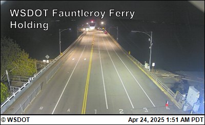
(Latest image from WSF camera at dock)
1:19 PM: The empty Kittitas has returned to wait at Fauntleroy. Meantime, WSF is detouring boats to downtown: “Seattle-bound traffic from Vashon or Southworth will be diverted to Pier 52 to off-load. But traffic bound for Vashon will not be loaded at Pier 52.”
2 PM: The Kittitas has left again, apparently to be put into service on the diverted runs that will head from Vashon/Southworth to downtown. No updates on repair progress.
2:40 PM: WSF says repairs were “successful” and the Fauntleroy dock is in service again:
Operations out of the Fauntleroy Ferry Terminal have resumed following successful repairs to the terminal bridge. Though the route will return to service, customers should anticipate longer than usual waits due to increased traffic. Boats are still attempting to move as much traffic and get back into position as quickly as possible …
Though it’s not mentioned in that update, Vessel Watch showed a third boat, M/V Issaquah, was summoned into service, at least temporarily.
2:53 PM: The King County Water Taxi is adding a run from downtown to Vashon at 3:30 pm to help with the backlog.
Our inbox suggests the citywide excitement over this weekend’s sold-out Taylor Swift concerts at Lumen Field is more intense than what preceded last week’s All-Star Game. So, two notes:
 EXTRA WATER TAXI AND RAPIDRIDE RUNS: Transit services are adding more runs for Saturday and Sunday, including Metro buses and the West Seattle Water Taxi. The WT will add 11:45 pm and 12:15 am runs from Pier 50 downtown both nights, and Metro has a special shuttle that will take concertgoers to the dock, as well as (updated) added C and H Line service.
YOUNGSTOWN COFFEE: The coffee crew at 6030 California SW is stoked. Here’s their announcement:
In celebration of Taylor Swift’s Eras Tour coming to Seattle this weekend, Youngstown will be running a special Taylor’s Version menu and giveaway! Our menu and contest is running now through July 23rd (Taylor’s final night in Seattle) and a winner will be chosen that evening.
Prizes include Speak Now tay’s version CD, Youngstown gift card for $25, Youngstown t-shirt, and sticker. To enter, visit our shop and purchase any drink off of our Diva Summer or Taylor’s Version menus and get one entry form.
Washington State Ferries says the #2 boat on the Fauntleroy-Vashon-Southworth run will tie up for the rest of today/tonight after its current run, because of a crew shortage – so it’s only running the #1 boat until further notice. (Check Vessel Watch for current location(s) – the #1 vessel, which will keep running, is M/V Kittitas.)

While traveling on SW Thistle between 35th and Delridge this week, we noticed three sets of markings that appeared to outline future speed humps. So we asked SDOT whether this was a continuation of the Westwood-area work that so far has included a new four-way stop at 25th/Trenton. Spokesperson Ethan Bergerson says this is specifically tied to safety for Chief Sealth International High School and Denny International Middle School, and that the markings we saw on SW Thistle won’t be the only ones added – they’re planning four on Thistle as well as others on 26th, 27th, and Kenyon, as shown on this map:

That’s from Denny_ChiefSealth_TrafficCalming_Postcard (002) (2) that Bergerson says SDOT sent to residents nearby. As it notes, the ones for SW Thistle are actually speed cushions – the difference is explained as “Speed cushions are like speed humps but have breaks that allow emergency vehicles to pass through them without slowing down.” No installation timeline yet.
Those lane closures that were supposed to happen last night for West Seattle Bridge maintenance work didn’t happen after all, SDOT says, due to crew availability. So all the work is supposed to be done tonight. It’s scheduled to start as early as 9 pm and be completed no later than 5 am, with one lane open each way in the work zone
 (Map of where SDOT was considering medians and a raised crossing)
Three weeks ago, we reported that SDOT was proposing landscaped medians in a stretch of West Marginal Way SW and asking for feedback. This afternoon, they say the idea of medians and a raised crossing has been “paused” as a result of what they heard. Here’s the announcement:
After gathering initial feedback on Phase 2 of the West Marginal Way SW Safety Corridor Improvements project, we have decided to pause on moving forward with the proposed median islands. We have decided to wait until after we have completed a post-project evaluation on Phase 1 of the project, which included installing a protected bike lane (PBL) and pavement markings and signs at the Duwamish Trail crossings, to determine what next steps are needed.
We have determined that is important to highlight the trail crossing across SW Front Street (near the Highland Park Way SW intersection) to increase visibility and safety, but we heard concerns about how a raised trail crossing may impact freight movement. Therefore, we are planning to look at other options, like pavement markings or green paint, to delineate the Duwamish Trail.
Next steps:
· Design a non-raised option for the Duwamish Trail crossing on West Marginal Way SW at SW Front St.
· Conduct a project evaluation of the PBL and Duwamish Trail crossing improvements with input from West Marginal Way SW stakeholders, including local businesses, trail and bike lane users, and the freight community.
· Collaborate with stakeholders to determine next steps based on the data findings.
We appreciate all the feedback we have received and will continue to seek input and share information along the way.
Back in April 2020, SDOT announced West Seattle’s first “Stay Healthy Street,” in High Point and vicinity. Now it’s planning to downsize. Here’s the announcement sent this afternoon, with word of a chance to talk with SDOT about it next week:
Over the last year we’ve been doing additional reviews and updating our Healthy Streets across Seattle based on community use trends and public feedback. For the High Point Healthy Street, we plan to remove the Healthy Street designation for some of the route while making another section permanent.
Permanent: Segment A – on 34th Ave SW, between SW Holden St and SW Graham St – is proposed to become a permanent Healthy Street. We plan to install permanent signage with a concrete block base and new painted curb space around it at each intersection. There is an option to replace the concrete base with a planter barrel if a neighbor wants to maintain it. Our Healthy Streets webpage has more information about adopting a planter.
Removal: We will be removing Segments B, C, and D and returning them back to a Neighborhood Greenway.
Segment B – SW Graham St, between 34th Ave SW and High Point Dr SW
Segment C – High Point Dr SW, between SW Graham St and Sylvan Way SW
Segment D – SW Holly St, between 34th Ave SW and 31 Ave SW
Please see the map (above) for your reference on the segments.Join us June 27 for an Open House. We will have light refreshments to share and staff will be available to listen to your feedback regarding this update.
When: Tuesday, June 27, between 5:30 pm-7 pm
Where: High Point Neighborhood House, 6400 Sylvan Way SW, Room 207
They’re also asking your opinion on what type of permanent signage a Healthy Street should get – this SDOT photo shows the two “main options,” planter or signpost:

More info on the options is here. Meantime, we’ll be following up with SDOT Monday on whether other Healthy Streets are in for changes.

Thanks to Kay for the photo and tip from Highland Park Way/Holden. She reported that no-parking signs had gone up for “Monday through mid-July,” and wondered if this meant the start of improvements at the intersection including the permanent signal replacing the temporary one that went up days after the West Seattle Bridge closed. Not yet, says SDOT spokesperson Ethan Bergerson:
Crews are planning to visit the intersection this month to verify where underground utilities are located so that we can confirm the exact location to install the new traffic signal poles. This will involve digging and then re-filling some small holes in the ground so that we can get a better look at what’s underneath the pavement.
We’re still working out the timeline for the installation of both the art and the signal poles. The biggest unknown right now is the supply chain timeline for signal poles, as the delivery date is outside of our control and it often takes a while to obtain this part. Once the signal poles arrive and are installed in the ground, the final step will be to work with Seattle City Light to hook up power so that the new traffic signal can be turned on.
The art to which he referred is this – a giant Steller’s Jay.

4:47 PM: Thanks for the tip! That’s one of two new stop signs on 44th SW where it meets SW Findlay [map]. This is just west of California/Findlay, where SDOT installed a pedestrian-activated “half-signal” last October. The reader who emailed us about this earlier today said “yield” signs had been there previously, adding, “Not sure why the change – no recent increase in accidents or near-misses. Also, when traveling north on 44th, the new stop sign is obscured by a tree.” Same tree that’s in our photo, but the sign only comes into view when you arrive right up to it. We have a question out to SDOT about the rationale for the installation.
6:50 PM: SDOT spokesperson Ethan Bergerson responded, “This was a standalone project. The new stop sign is intended to enhance safety and provide clarity for people traveling through this intersection.”
SDOT is looking for feedback on a new proposal for part of West Marginal Way SW: landscaped medians:
We are seeking input on proposed landscaped median islands and a raised crosswalk. We are looking to understand driveway operations that would inform the median island size and feasibility.
Here’s the notice with information on proposed locations and how to comment. The deadline is June 20. SDOT spokesperson Ethan Bergerson also says they’re planning to evaluate the recently installed protected bike lane and “other safety elements” this summer.
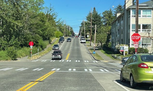
Thanks for all the tips! Multiple emails alerted us to the new all-way stop configuration for 25th/Trenton, with marked crosswalks, on the northeast edge of Westwood Village. We asked SDOT about it; their reply: “This is a new all-way stop. The goal is to improve safety for everyone but especially pedestrians. There are a relatively large number of pedestrians crossing, including high school and middle school students. The new stop signs will also help transit make the left turn from Trenton to 25th.” It’s been five years since pathway improvements were built just north of the intersection.
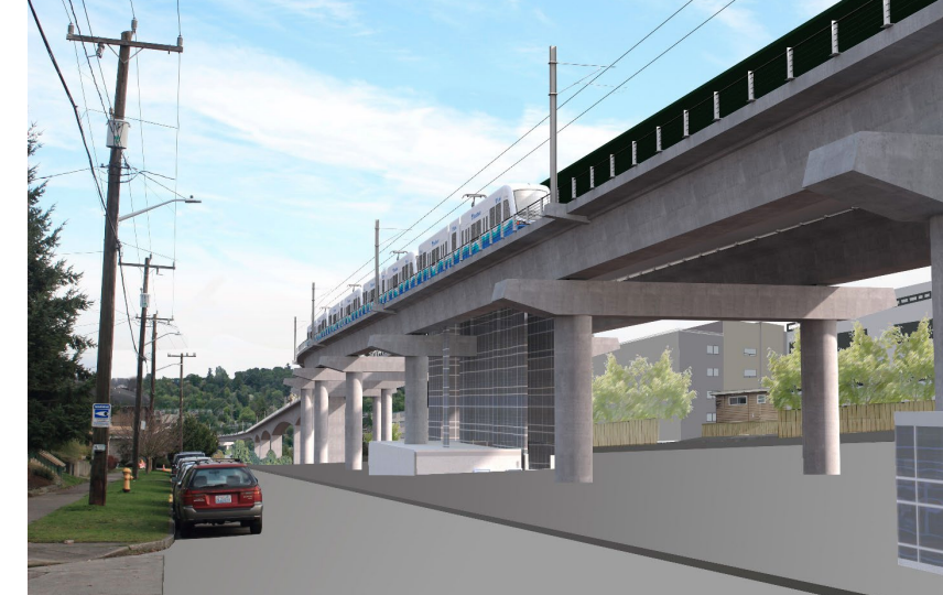 (Sound Transit rendering, possible routing at Genesee looking east toward Avalon)
By Tracy Record
West Seattle Blog editor
Two dates of note on the Sound Transit light-rail extension timeline have been pushed back, ST told the West Seattle Transportation Coalition tonight.
One is the date ST will release the final Environmental Impact Statement for the West Seattle extension, which has to happen before the ST board finalizes the routing and station locations.
The other is the date the Ballard extension is projected to open – important for West Seattle because light rail from here won’t go all the way downtown (and beyond) until then; riders from West Seattle will have to transfer in SODO.
ST’s Leda Chahim and Jason Hampton provided the updates – no slide deck, so we don’t have visual highlights. Chahim first spotlighted the split between timelines for the West Seattle and Ballard extensions, since various factors led to the West Seattle “preferred alternative” being identified first, rather than the two extensions’ planning processes rolling along in parallel. Then Chahim said they’re not expecting to publish the final EIS for West Seattle until next year – and not early in the year, either; she said it would be after the first quarter. The most-recent timeline had been “late 2023,” which is still on the ST project website tonight, though Chahim said some updates would appear there soon.
She also said the final EIS will incorporate the “further studies” items – they’ll all be fully analyzed. Otherwise, they’re “still working on details’ but expect community engagement “this fall” for the stations and design concepts. Before then, they’ll be out at fairs, festivals, and the Farmers’ Market, to get reacquainted with the community.
WSTC’s Deb Barker asked for more about the status of “refinements” (aka the “further studies” items). Hampton took on that reply. He recapped what’s been studied – potential access improvements for the Delridge station and shifting a station entrance for The Junction. Chahim said the ongoing project website will be updated in the next few days. So with Ballard on a different timeline, what will that mean for the gap between trains from West Seattle going to SODO and going beyond? The additional work on Ballard has taken almost two years so that extension is now not expected to open until 2039 – which means a seven-year gap, previously five years (Chahim said 2032 is still the projected date for West Seattle). West Seattle RapidRide routes to downtown will continue for all those years, Hampton said.
Barker wondered what ST is doing to educate candidates, considering that this fall’s local elections will bring lots of changes (for example, two Seattle ST board members are not running for re-election, King County Councilmember Joe McDermott of West Seattle and City Council President Debora Juarez of North Seattle). Chahim didn’t know of anything in particular.
WSTC chair Michael Taylor-Judd suggested that ST needs to think about incorporating commercial space at stations, considering the “much-loved” neighborhood businesses that are likely to be displaced. He talked about how the supportive-housing Cottage Grove Commons building included space for the nonprofit Delridge Grocery Co-op, which has taken a while to really blossom but is finally getting there.
The Sound Transit updates followed an appearance by Metro reps to discuss one specific service:
TRAILHEAD DIRECT: This is a seasonal service for taking transit to a faraway hike! Ryan Miller from Metro talked about the program, which started with a pilot in 2017, then expanded to connect with Seattle light rail in 2018 and to serve destinations that people were asking about. They “started the program to mitigate parking access” but learned that the program really was about equitable access to outdoor destinations. That led to a new route from South King County in 2019. The pandemic led to a time of re-evaluation; they brought back two popular routes, from Issaquah and from Capitol Hill, in 2021. That year, though, they also were affected by the operator shortages that have plagued the entire system. So now they’re focusing on the route from Capitol Hill, and “that’s where we’re at for this season,” said Miller.
In Q&A – what’s the cost? Same as other transit – no special fare. (That also means free for 18 and under, interjected Metro’s Al Sanders.) And the buses do have bicycle racks. In response to another question, Miller said the lessons they’ve learned from Trailhead Direct have helped them when planning service restructuring, to include parks and other destinations. WSTC’s Barker pointed out that Alki service is spotty since Route 37 is long suspended; Miller noted 50, 773, and 775 still run. What types of coaches does Trailhead Direct use? asked WSTC’s Kate Wells. They tend to be a “little smaller” than the standard Metro coach, Miller said. The drivers are with Hopelink, so they don’t come from the pool handling general Metro service.
BOARD ELECTIONS: Three members were re-elected; no one was nominated for three vacant positions, so if you’re interested, contact WSTC and get involved.
NEXT MEETINGS: WSTC remains on an every-other-month schedule – so the rest of the year will include July 27th, September 28th, November 16th (tentative), 6:30 pm. They’re still mulling locations in hopes of holding hybrid meetings (in-person and online).
Just received these notices from SDOT:
-This weekend, SDOT will be paving Myers Way S between Olson Place SW and 2nd Ave SW. The road will be closed to all vehicles except transit from 7 a.m. Saturday, May 20 to 7 p.m. on Sunday, May 21.
-On Saturday, May 20, SDOT will be performing sidewalk construction at Chelan Ave SW and W Marginal Way SW to build a new curb ramp.
The Legislature says Washington State Ferries needs to generate a certain amount of revenue. Now the Washington State Transportation Commission, which sets fares, has to decide how to raise fares to meet the requirement The WSTC has opened a survey with questions for you; you can answer them here. Its results will be used to shape a fare proposal that’ll be made public next month.
From Washington State Ferries:
Due to lack of crew, the final sailing for the #2 Cathlamet will be the 5:55 p.m. Fauntleroy to Vashon departure. The #1 Kittitas will remain on the #1 boat schedule for the remainder of the night.
If that changes, WSF will update here.
 (SDOT photo, January)
Four months have passed since a leaky cylinder was removed from the West Seattle low bridge (officially known as the Spokane Street Swing Bridge). Soon after that, the bridge reopened to surface traffic after a three-week closure. But the bridge has been running without that cylinder ever since, and that means it takes longer to open and close for maritime traffic; a post-reopening briefing noted that other cylinders would be removed for refurbishment one at a time. So what’s happened since then? We asked SDOT, whose spokesperson Ethan Bergerson replied:
We’re continuing to work on overhauling the damaged cylinder that was removed in January. This involves dismantling the cylinder and conducting a forensic evaluation of each of the parts to determine if there are any modifications that we can consider to improve the life of the cylinder. It will likely be a few months before we complete this overhaul and reinstall this cylinder. When we reinstall the repaired cylinder, we will also remove a cylinder which is currently in service so that we can complete an overhaul of that one as well.
Over the next five days, some other work is planned that will affect maritime traffic (but not vehicles/pedestrians/bicyclists) – here’s the SDOT advisory on that:
Between 1 AM Saturday, May 13 and 1 AM Wednesday, May 17, maritime vessels will have limited access under the Spokane St Swing Bridge to navigate the Duwamish Waterway. We do not expect impacts to people driving, walking, or biking.
During this time, only the east span (side) of the bridge will swing open and closed for maritime vessels on the Duwamish Waterway. We’ve been communicating with the U.S. Coast Guard about this work, which will limit when some larger vessels can pass through.
This work is necessary for us to perform service and inspection on one of the bridge’s hydraulic pumps. The bridge has three hydraulic pump units at each pier to push hydraulic fluid to the bridge’s cylinders, allowing the cylinders to lift and swing the bridge open and closed.
We’re completing maintenance on all the hydraulic pump units for both piers in 2023. We’re starting with the west side of the bridge and will return later in 2023 to work on the east side.
This city webpage chronicles the ongoing work.
 “We’re in the enviable position where people want more transit. But – we’re unable to give it to them.”
So said Metro‘s general manager Michelle Allison toward the end of a just-concluded media briefing with early warning of route suspensions planned for the next twice-yearly “service change,” on September 2nd.
One West Seattle route is on the list – Route 55, which is scheduled for only six trips a day now, five in the morning, one in the afternoon (its schedule was officially reduced last September). “Scheduled” is the key word here – as riders know, Metro has been frequently canceling trips. Allison said the point of suspending more routes – 32 of the current 156 system-wide – is to improve reliability so that by the time they get to September, “the schedule IS the service,” not just an aspirational plan.
Here’s the full list of what they’re planning now for a September 2nd change. And needless to say, currently suspended routes aren’t in the plan for restoration – that would include long-suspended West Seattle Route 37. We asked how they can be certain that this round of suspensions will put them on the road to reliability. Allison, who took over as Metro GM earlier this year, said they believe they’ve done enough analysis and “daylighting” of personnel and supply-chain reality, that they have an accurate picture of what they can reliably deliver. She added that what’s on the schedule starting September 2nd is roughly equal to what, with ongoing trip cancellations, they’re actually delivering now.
Again, the changes announced today – and other forthcoming adjustments – won’t officially be part of the schedule as of September 2nd – so until then, Route 55 is still, technically, operational.

TUESDAY REPORT: Seen in The Junction today – SDOT crews repainting road markings. Warmer weather this time of year tends to launch a lot of work like this that couldn’t be done during the cold, rainy season, so be extra watchful, and be aware you may need a few extra minutes to get where you’re going.
ADDED WEDNESDAY: We asked SDOT for some context. Spokesperson Ethan Bergerson replied:
Each year, we repaint over 1,500 crosswalks across Seattle to keep markings bright and visible. This work requires dry weather, and so as you guessed the spring and summer is re-painting season. This is made possible thanks to funding from the voter-approved Levy to Move Seattle.
This year, we’re repainting about 160 crosswalks in Seattle City Council District 1. Our signs and markings crew have already completed roughly 125 of these crosswalks, and have about 35 crosswalks left to paint.
 (SDOT camera image)
Discussions of the hole that shut down the state-owned ramp from the West Seattle Bridge to Highway 99 (reopening tomorrow) have swerved into concerns about the condition of the city-owned Spokane Street Viaduct. (That’s the formal name for the east half of the West Seattle Bridge, from Highway 99 to I-5.) Those concerns also came up during the 2 1/2-year repair closure of the west half of the West Seattle Bridge. The eastbound Spokane Street Viaduct, not part of the repair project, did close for work including pothole repairs multiple times during those 2 1/2 years, and SDOT did deck scanning for a more extensive assessment. Then in July of last year, the city announced it had received a $5 million federal grant to resurface the entire eastbound side of the SSV. At the time of that announcement, SDOT told us that resurfacing would happen in “the next few years.” So we asked last week where that plan stands, and got this answer today from SDOT spokesperson Ethan Bergerson with a somewhat speedier timeline: “We are currently in the design phase of this project, and anticipate starting construction as soon as next year. The construction work will address the frequent overlay issues that we have been encountering on the eastbound lanes of the Spokane St Viaduct.” The eastbound lanes are on the original 1940s-built SSV structure; the westbound side was built a decade-plus ago to widen it
 (WSB photo, Wednesday)
2:52 PM: Six days after that hole forced the Washington State Department of Transportation to close its ramp connecting the eastbound West Seattle Bridge to northbound State Highway 99, here’s the latest:
As reported over the weekend, crews poured concrete on Saturday, and now it’s curing. WSDOT spokesperson James Poling explained why the schedule remains the same as announced last week (which would reopen the ramp by this Saturday): “The concrete curing process requires our offsite materials lab breaking test concrete cylinders from the pour at certain time benchmarks (24 hours after pour, 48 hours after pour, etc.). Once a test cylinder reaches a strength to safely reopen traffic, the bridge ramp will reopen. The timetable remains the same at this time as our crews await a test cylinder to pass that strength benchmark.”
Meantime, since there was initially much public confusion over who’s accountable for the ramp, and some commenters said they had filed ramp-pothole reports with the city, we asked the Seattle Department of Transportation if they’d received such reports about the state-owned ramp and what happened to them. Spokesperson Ethan Bergerson replied, “When the public reports a pothole which is outside the city limits or not on SDOT’s right-of-way, it will be routed to the correct transportation agency. Over the past few months, we notified WSDOT of several public reports of potholes in this location.” We’ll follow up on that, as WSDOT had said previously they weren’t aware of the hole – at least at the magnitude that forced last Tuesday’s closure.
4:28 PM UPDATE: Just got another update – the ramp concrete “has cured more quickly” than expected, and the ramp will be open by 5 am tomorrow (Tuesday).
 (WSDOT photos)
The Washington State Department of Transportation says its crew made more progress today toward repairing and reopening the ramp between the West Seattle Bridge and northbound Highway 99. It’s been closed since Tuesday night, when a 5′ x 4′ hole in the 64-year-old ramp caused tire blowouts for at least five drivers. WSDOT’s latest update: “Today we’ve poured concrete. It usually takes a few days for this type of concrete to cure properly in order to safely reopen the ramp.”

We’ll find out on Monday if that’s altered the schedule – originally announced as 10 days, which would mean reopening by next Saturday. In the meantime, your options for getting to Highway 99 are the 1st Avenue South Bridge or via the 1st Avenue exit on the eastbound bridge, leading you into SODO, where you can get onto 99.

That map from SDOT shows where work is expected to start soon for pedestrian improvements at Roxbury/Olson [map], which have been in the works for at least three years. The city has sent notices to people in the area, but it’s a busy corridor, so many others who use it need to know too. From the SDOT advisory:
This work will include:
-A new pedestrian signal on the northwest side of the intersection
-Shifting the crosswalks across SW Roxbury St so they’re better aligned
-Curb bulbs that extend the sidewalk corners for people walking on the south side of the intersection
-Curb ramps for improved ADA (Americans with Disabilities Act) accessibility
Once work begins, it is expected to last six months, SDOT says, with work hours primarily 9 am-3 pm on weekdays. They’ll have flaggers to help with lane closures. Here’s the full construction notice.
 (WSB photos, noontime today)
When we went over today for another look under the damaged ramp to Highway 99, we arrived just as that crew was ascending to the ramp’s underside. It’s been two days now since a 5′ x 4′ hole in the ramp took out tires on at least five vehicles before WSDOT ordered it closed. It’s a state-owned structure, as is Highway 99, to which the ramp leads from an exit on the eastbound West Seattle Bridge. WSDOT spokesperson James Poling tells WSB that repairs remain on schedule – that’s the schedule announced yesterday, 10 days, which would mean the work is expected to be done by May 13th. He says the lift we photographed carries workers 38 feet up from ground to ramp. So what exactly is happening now? Poling replied, “Most of the concrete removal is now complete. The next repair step is building forms underneath the deck and sealing the space between the girder webs. This will take about 36-48 hours.”

As we reported yesterday, the ramp was built in 1959 and last inspected in August 2022. It remained open to traffic during the West Seattle Bridge’s two and a half-year closure, still accessible via a ramp from surface Spokane Street, except for a week-plus closure to repair a deck hole about 100 feet from this one.
P.S. We found more information about the ramp via this inventory map – including its official name, E-N Ramp, and confirmation that its inspection schedule is every two years

| 5 COMMENTS