West Seattle, Washington
03 Wednesday
Through the end of this year, 0.15% of the sales tax you pay funds the voter-approved Seattle Transit Measure. That would double to 0.30% if the City Council and Seattle voters approve the renewal/expansion that Mayor Katie Wilson officially introduced this afternoon. She said it’ll make living in Seattle more affordable by enabling more people to “live car-free or car-light.” She acknowledged that raising the sales tax isn’t ideal but noted that it’s one of the few revenue-raising tools available under state law. Besides paying for more transit – 280,000 additional Metro bus trips a year, 100,000 more than the current measure funds – it also would pay for 22,000 free ORCA transit passes, more than double what the city provides now, said acting SDOT director Angela Brady during the announcement event at City Hall. The passes are now available to Seattle Promise scholars, low-income Seattle Preschool Program families, and Seattle Housing Authority residents. The measure’s renewal/expansion would also make those passes available to Housing Choice Voucher participants.
The mayor’s announcement says the Transit Measure isn’t just about buses: It also would “support the design and delivery of Sound Transit’s West Seattle Link Extension, Ballard Link Extension, and Graham Street Station.” The 0.30% sales tax would generate an estimated $138 million average per year for the 10 years of this measure, which is proposed to go to voters in November. Council review starts this Thursday and will be led by District 1 City Councilmember Rob Saka, who chairs the council committee that oversees transportation. We’ll add the specific text of the proposal when we get it; the slide deck for Thursday’s council meeting is now available, and we’ll add some highlights from that soon.
(Added Wednesday: WSF recording of meeting)
By Tracy Record
West Seattle Blog editor
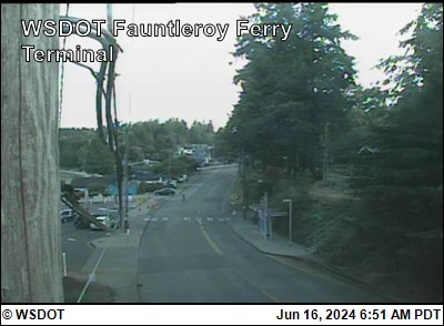
If you’re interested in Washington State Ferries, you have another chance to join one of its systemwide online community meetings – tonight at 6 pm. We watched the first version of the meeting this afternoon – here’s how it unfolded:
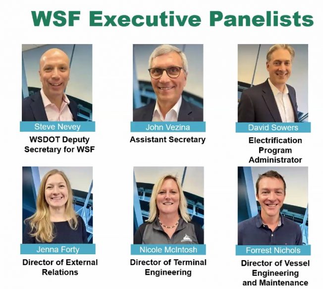
WHO WAS THERE: Above is the slide identifying the system executives participated. As for those in attendance, 60 people were reported to have signed in as the meeting began. They were polled about their routes of interest; Fauntleroy-Vashon-Southworth came in at 19 percent.
UPDATES: Ferries boss Steve Nevey was first up. He started with the system’s 75th anniversary on June 1 – that date in 1951 is when, he said, “the state decided to take over the service.”
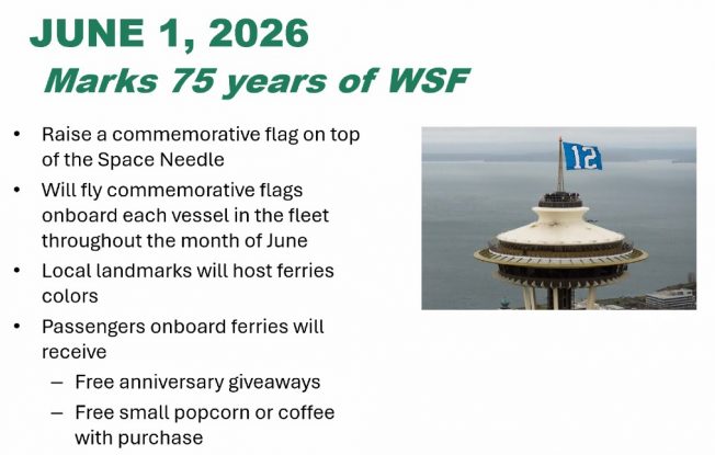
WSF has a variety of anniversary events planned including special flags to fly on the ferries and even one atop the Space Needle. Free small bags of popcorn and cups of coffee will be offered (with purchases) in the galleys on Monday, and various giveaways are planned throughout the month.
Next, he updated employment stats – deck and engine staffing are among the categories improving, Nevey said:
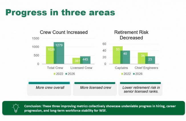
The percentage of “retirement risk” in key crew categories is down, too – among captains, from 53 percent to 40 percent; among chief engineers, from 34 percent to 20 percent. “We’re really encouraged by the way we’re trending in these areas. … I feel like we’re really getting our arms around our workforce issues.” Cancelled sailings because of short staffing are “way down,” he emphasized.
Next up, Jenna Forty on the updated Service Contingency Plan (read it here):
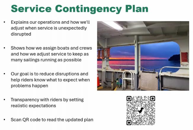
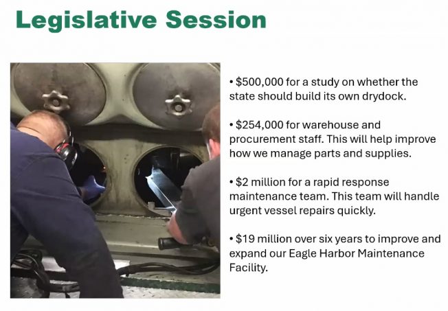
“With 21 vessels … we really don’t have a margin of error.” She didn’t get into specifics of the plan, just noting that it’s meant to help ensure riders know what to expect. She also had several notes from the Legislature’s session, including securing $2 million for a “rapid response” maintenance/repair team to get ferries fixed faster.
On to the World Cup plan, addressed by Forrest Nichols:
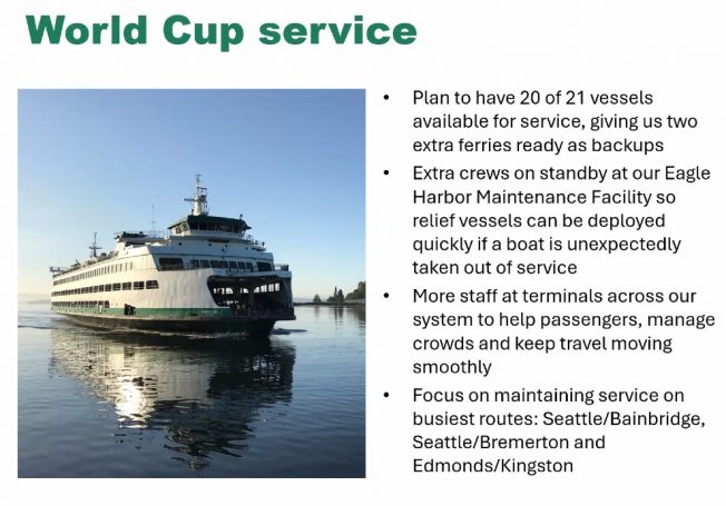
The summer schedule calls for 18 boats, so having 20 ready means they’ll have two on standby to quickly plug in, in case of unexpected trouble, Nichols said.
Next, David Sowers updated the system-electrification program, both terminals and vessels, stressing the need to push forward with what’s ultimately a system-modernization plan:
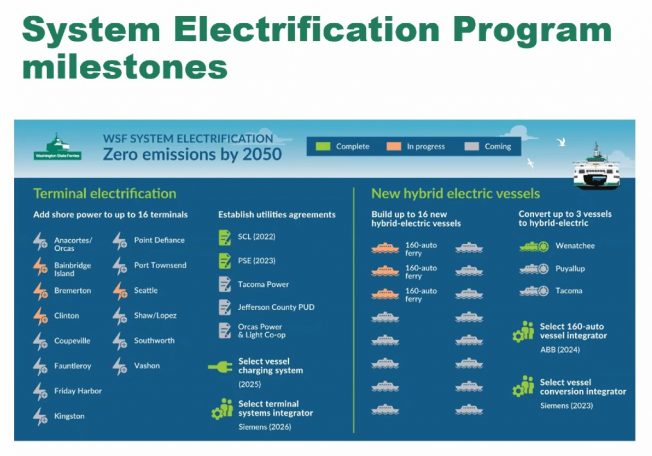
As for the new ferries being built in Florida, the next year will be spent finishing the design for the first vessel, and steel cutting will start in August 2027, with “that first boat arriving in Puget Sound in 2030.” WSF has issued a Request for Qualifications for its first terminal electrification projects, using the design-build process, and hopes to have one slip electrified as soon as 2029.
TERMINAL PROJECTS: Nicole McIntosh presented these updates. They included projects that were under way or recently completed. Only one Fauntleroy mention, and it was brief – she said the intersection project, where the dock meets Fauntleroy Way, is now advertising for bids and still expected to start work this fall.
OTHER UPDATES: The system’s second-in-command, John Vezina, recapped the recently finalized pet policy.
He also said – without accompanying slides – that WSF had made a wrong choice of vendors for a ticketing-system update, and spent a lot of money in the process; how much, he said, they’ll be disclosing (“it’s all public record,” he said more than once), but in the meantime, they’ll be seeking a new partner. “We stopped, we’re reassessing.” (This appears to be a reference to the situation detailed in reports including this one.)
He switched gears to the state of trying to get wi-fi on boats and at terminals. They’re testing it “with T-Mobile and another partner” on M/V Chimacum for starters and will soon have a test at the Bremerton terminal too; others will follow, after an evaluation period at year’s end.
Q&A: This was the second half of the meeting, starting at 12:39 pm. (We’ve noted the Triangle Route-related questions in bold type.) First question: “Could ferry system be split into two parts, the San Juans and (everywhere else)?” Forty replied: “In short, no.”
Second question had to do with the reservation system, which doesn’t involve this area … Third question, how long will M/V Puyallup be on Bremerton route? Answer, it’s filling in while M/V Kaleetan is out for work that may not be complete until fall, but it will likely move back to Edmonds-Kingston in late June … Fourth question involved how they’re planning to ensure charging systems for vessels will work with their vessels; answer was technical … Fifth question, how will service be disrupted during Fauntleroy terminal construction? McIntosh said they’re working on that, nothing to say yet … Sixth question, canceled sailings info has disappeared from weekly updates, when will it return? They’re working on a data issue, was the reply … Sixth question comes up every time – when will the route to Sidney B.C. be restored? Nevey said the answer remains 2030 … Seventh question, classification of new vessels – SOLAS-compatible? Not likely, was the reply; WSF has only one that is, M/V Chelan … Eighth question had to do about budgeting and money that has to be spent on the electrification program and cannot be diverted elsewhere; Forty noted that the Legislature sets a lot of parameters for what WSF gets/can spend … Ninth question, what will the Triangle Route run for the World Cup time? They expect to keep three Issaquah-class ferries on the route through July … Tenth question was about electrification on a north route …
Eleventh question was about battery-fire concerns aboard an electrified boat; a regulatory process oversees everything, was the reply, and they have sensors and systems that would address that – the technology is “well established” around the world so standards for construction and installation of batteries have been refined. They don’t believe a fire “would go beyond the individual cell” as a result … Twelfth question was about a Bainbridge roundabout … Thirteenth was about fares, with a reiteration that the state Transportation Commission makes those decisions … Fourteenth was about World Cup service; WSF believes the plan outlined earlier in the meeting allows “more resources” to reduce or eliminate service disruptions … Fifteenth question had to do with verifying people’s eligibility for certain fare levels and the fact some discounted levels are not available via kiosks … Sixteenth was a Lopez Island reservations question … Seventeenth also involved the San Juan Islands … Eighteenth question, why can’t residents be prioritized for service/fares? Vezina said the Legislature sets the revenue levels that WSF must bring in – right now customers pay what amounts to 55 percent of the costs, and the other 45 percent comes from taxpayers, so fares and service have to be equal for everyone … Nineteenth question, what about integrating Good to Go with WSF? Forty said they’re looking at it, and also at possible integration with ORCA … Twentieth question, signage/announcements on the boats regarding civility “We Sail Together”; Vezina said it’s important because employees have been targeted by abusive language. Yes, it’s frustrating when something isn’t working well, but there’s no reason to do that to employees. “Showing gratitude to the people who show up each day to get you where you need to go” is appreciated, he added.
Twenty-first question was about San Juans service … Twenty-second question had to do with legally required loading procedures … and the meeting wrapped at 1:15 pm. You can get the link for the 6 pm meeting here; that same page will eventually have video from the meetings.
Two Washington State Ferries notes:
TICKETING TROUBLE: According to the WSF alerts/bulletins page, “Vehicle reservations, Wave2Go ticketing and terminal ticket sales and redemptions are offline due to a systemwide outage. … Please allow extra time for payment processing at your departure point.” No ETA for a fix. (6:45 PM: Working now, as of early evening, reports WSF.)
ONLINE MEETINGS TOMORROW: Two chances for updates and Q&A with WSF senior management tomorrow (Tuesday, May 26) during the periodic systemwide community meetings – both to be held online, noon and 6 pm. You can go here to get the link for participation in either meeting (or both, though they say the presentations will be identical).
 (WSF file photo)
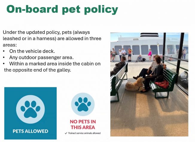
After a nine-month trial, Washington State Ferries‘ revised pet policy is about to be finalized. WSF announced the details and timeline today:
Updated pet policy
Just ahead of the holiday weekend, WSF will begin a six-week education and transition period to help people learn the new rules before they take effect on July 1. By that date, onboard signs will be installed showing where pets are allowed and not allowed. Pet waste stations also will be added, as owners are responsible for cleaning up after their animals.
Under the updated policy, pets are allowed in three areas:
-On vehicle decks
-In outdoor passenger areas
-In marked areas inside cabins on the opposite end from the galleyPets are not allowed in the galley or on passenger seating and tables. They also cannot stay inside the cabin on the galley end of the vessel. Pet owners may pass through this restricted area but must take the most direct route and not stop.
If a pet is not under control or is not cleaned up after, a crew member may ask the owner to move the pet to the vehicle deck or an outdoor area. Service animals are allowed in all areas, as required by law. Livestock must stay in proper enclosures at all times.
“Our updated pet policy builds on a trial that began last summer, when pets were allowed in most passenger areas except galleys and on indoor seats,” said WSDOT Deputy Secretary for WSF Steve Nevey. “We heard from employees and customers. Some supported the trial, while others had concerns about cleanliness, safety and enforcement. This updated policy strikes a balance by allowing pets in certain areas while addressing those concerns.”
Got questions? The systemwide online community meetings next Tuesday would be a good time to ask.
Two “People Streets/Public Spaces“ projects are planned in West Seattle – same ones mentioned here briefly after SDOT released a list of levy-funded 2026 projects – and drop-in informational events are planned at both in the next several days:
At 18th/Delridge, 9:30 am-11:30 am tomorrow (Saturday, May 16):
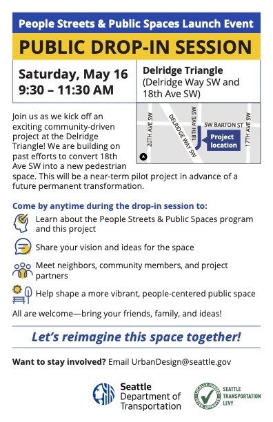
(Neighbors first mentioned this in a comment discussion after the recent shooting at an encampment on the city-owned land in the vicinity.)
The second one is 2:30-5:30 pm Tuesday (May 19) at The Good Society (California/Lander):
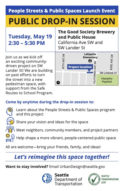
The stretch of Lander alongside Lafayette Elementary has history as a “school street,” which is what the flyer is alluding to by noting “past efforts.”
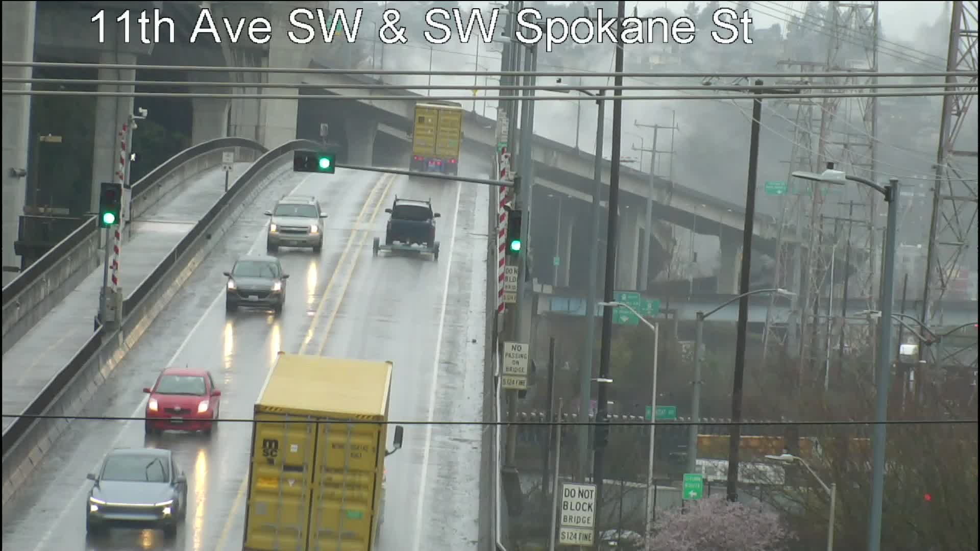
When WSDOT announced Monday that it would close the northbound 1st Avenue South Bridge all weekend again, starting this Friday night, though one area bridge – the West Seattle low bridge – already had an all-weekend closure planned, we asked SDOT if the latter was still on. We had already asked what time the low-bridge closure would start, as the original announcement was just “May 16-17.” Here’s the statement we got this afternoon with answers to both questions:
The Spokane St Swing Bridge (also know as the West Seattle Low Bridge) will be closed to all vehicles starting at 7 a.m. Saturday, May 16 and reopen by the morning of Monday, May 18. People on bicycles and walking will still be able to use the bridge, although there may be more bridge openings than usual due to the maintenance work.
We have been working closely with WSDOT to coordinate around their planned construction on the First Ave S Bridge. The work on Spokane St Swing Bridge will continue as planned because it is not a detour route for the First Ave S Bridge and the West Seattle High-Rise Bridge has enough capacity to carry the increased traffic volumes of people affected by both closures.
SDOT says it’s closing the low bridge to drivers so it can “replace the tail lock cylinder, motor, and hydraulic pump.”
By Tracy Record
West Seattle Blog editor
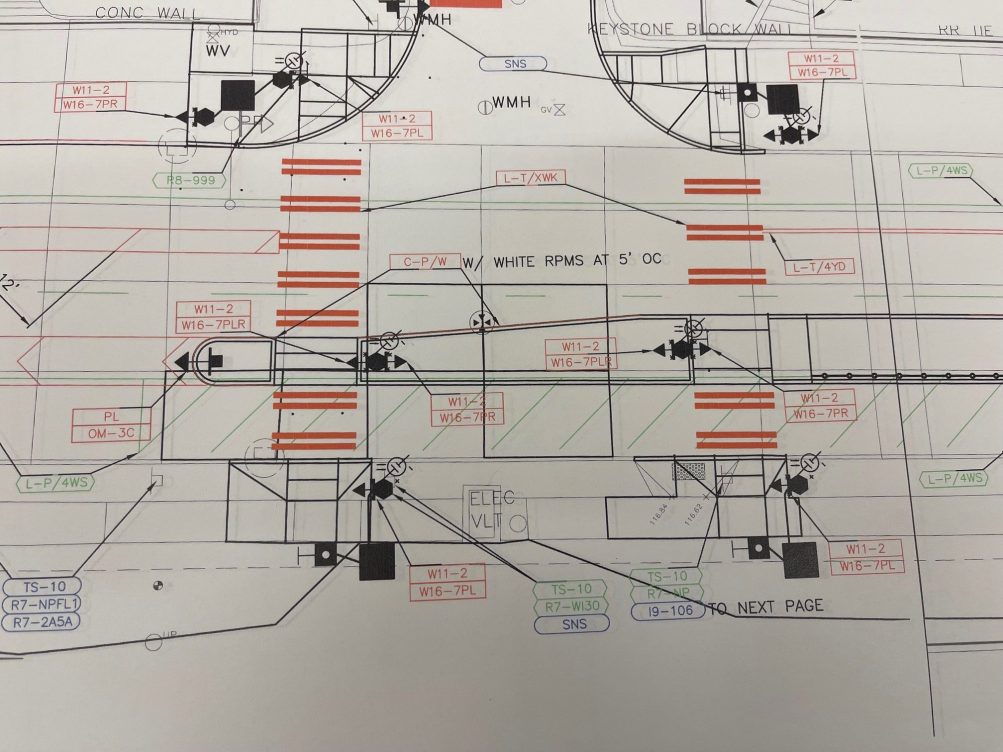
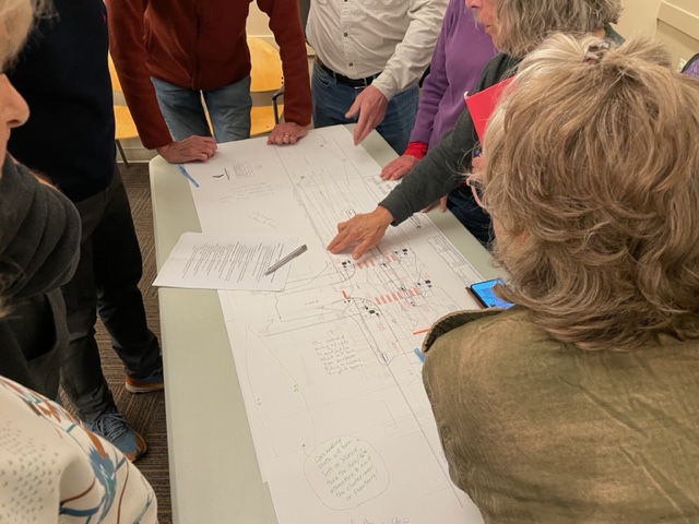
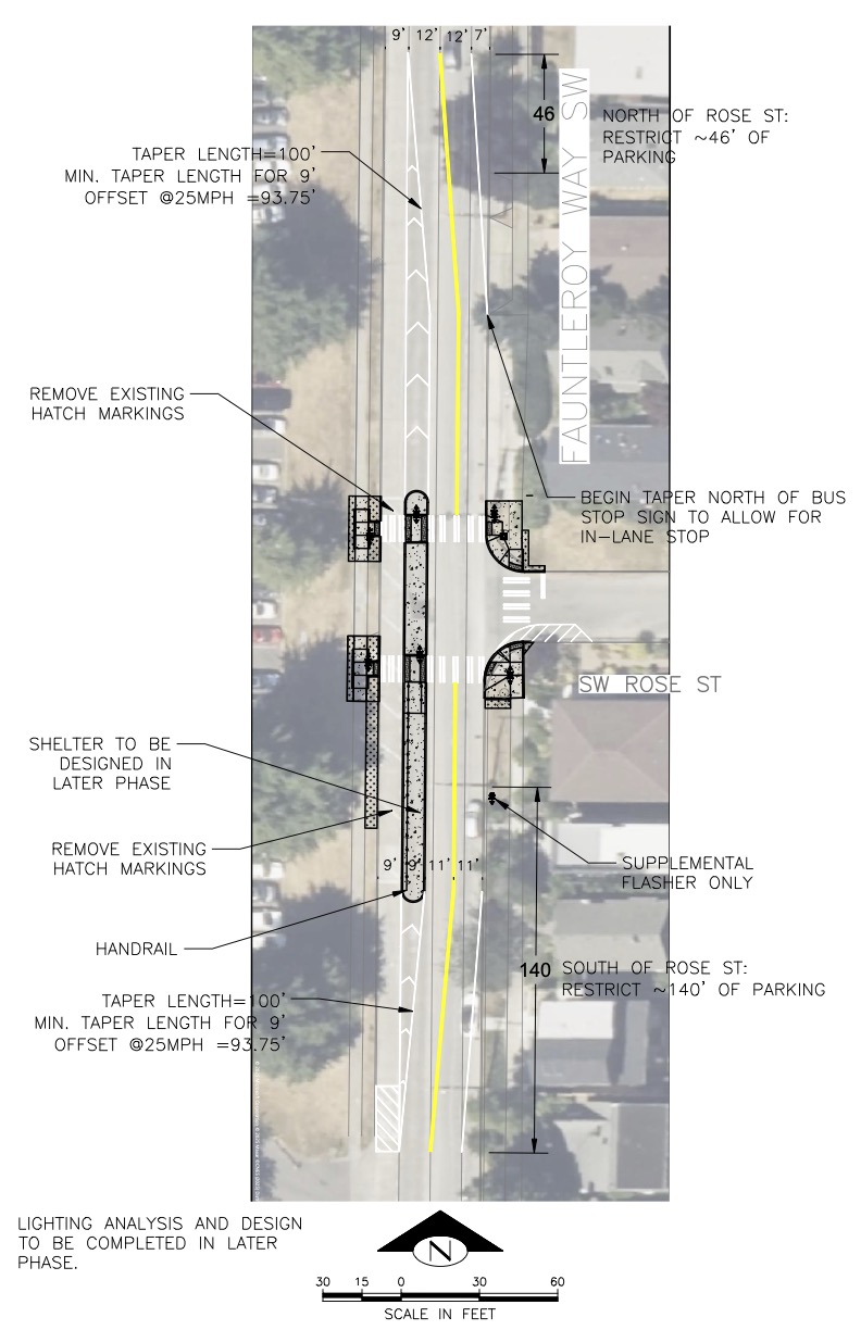
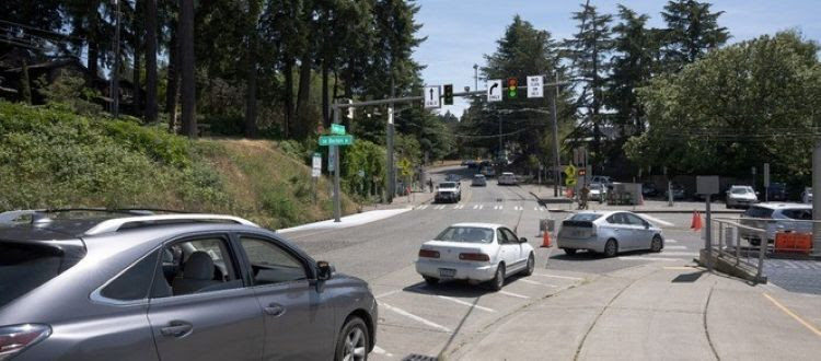
About 30 people gathered at Southwest Library Wednesday night to talk about SDOT‘s plan for a new crossing at Fauntleroy Way SW and SW Rose Street [map].
Most expressed the opinion that SDOT’s concept for the crossing – at the spot where the city removed a painted crosswalk 19 years ago – is overkill.
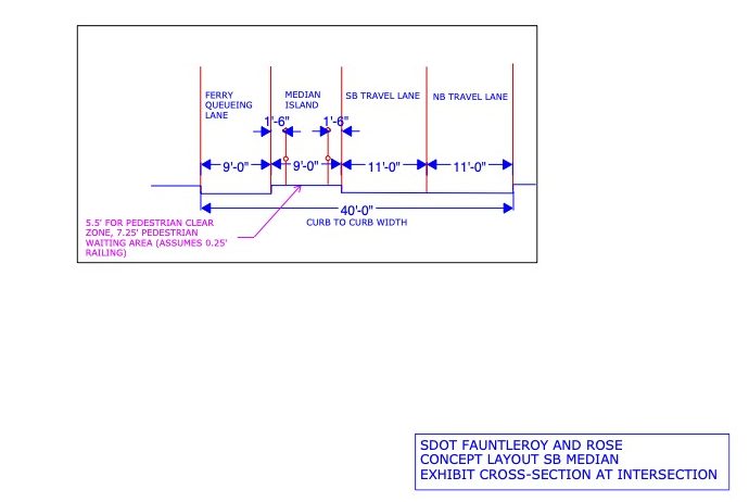
Most of the concerns centered on the raised median that is planned between the ferry holding lane alongside Lincoln Park and the southbound travel lane of Fauntleroy Way, though there was not a universal agreement on what might be better.
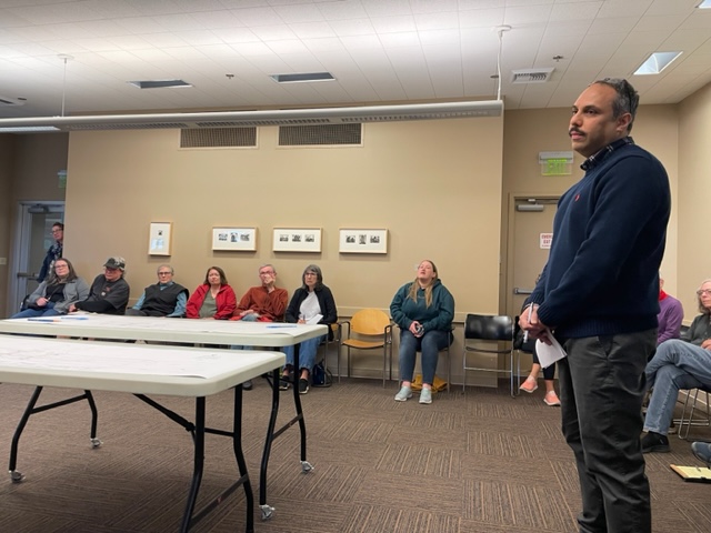
SDOT reps, including chief safety officer Venu Nemani, explained that this is a Transit Spot Improvement project, since the RapidRide C Line stops north of the intersection on the northbound side. They didn’t make a presentation, but rather talked to attendees, seated around the periphery of the room, until breaking into two groups to stand around tables with the sketched-out design, same one unveiled last fall:
At the start, Frank Immel of the Fauntleroy Community Association – which joined the Morgan Community Association in organizing the meeting – implored attendees not to “beat up” the SDOT reps, pointing out that while government is often criticized for “not doing anything,” this is a situation in which they responded to community concerns by “doing something.”
SDOT’s Ching Chan noted that this is a rare RapidRide stop without crossing improvements, and described this as a fairly simple project, “quick and low-cost,” and saying there hadn’t been “heavy engagement” with the community because this is about safety “and for SDOT safety is non-negotiable.”
Nemani said traffic data to help with decisionmaking about the intersection was gathered in fall of 2024. That became a point of criticism for some, saying that wouldn’t have been an accurate sampling of how busy the area can get with summertime ferry usage, park usage, etc.
Regardless of traffic-volume accuracy, Nemani noted that many drivers were going well over the 25 mph speed limit. Some area residents seized on that as a concern, worrying that some will zip right through what’s meant to be the holding lane when it’s not full, endangering the pedestrians on the new median, waiting to cross. “Ferry people” rushing to get to the dock were cited numerous times as a source of concern.
And that, Immel observed, is what makes this location different from other places in the city with raised-median crossings – this is the only residential neighborhood in the city with ferry traffic.
Some advocated for the other options Nemani said had been considered – a traffic signal activated by pedestrians, like the one a few blocks south on Fauntleroy, or flashing beacons without a median. He said analysis of the situation in light of the Manual of Uniform Traffic Control suggested it didn’t rise to the need for one of those other options. Then why did other intersections on Fauntleroy have pedestrian-activated signals? he was asked. He said repeatedly that he couldn’t speak for why past SDOT employees made the decisions they did.
Another thing about the median, he noted – it’ll enable more poles to be mounted with the flashing beacons, so the intersection will have more of them. (And if you’re wondering about parking, he said it will lead to the loss of eight spots along Fauntleroy.) For those worried that some drivers would use side streets to avoid this area, Nemani said they could add traffic-calming features to side streets to dissuade or at least mitigate that.
The concerns kept coming: What about the ferry-bound drivers who approach from the south and make U-turns to get into the line? What if a broken-down vehicle blocks the lane between the curb and the median? One person insisted, “The median is not necessary at all.” The meeting ended without a summary, but those on hand had received an hour and a half – 50 percent longer than the meeting’s expected length – to air their fears.
WHAT’S NEXT? Chan told us the feedback will be considered in their final decisionmaking. As for who has the final say, she said Nemani’s input would certainly carry weight. The plan would likely be finalized by midsummer and they hope to start construction by year’s end. We also asked about the project budget; though the cost wouldn’t be clear until they know exactly what they’re building, SDOT’s Aidan Bernal told us that right now the budget is ~$250,000.
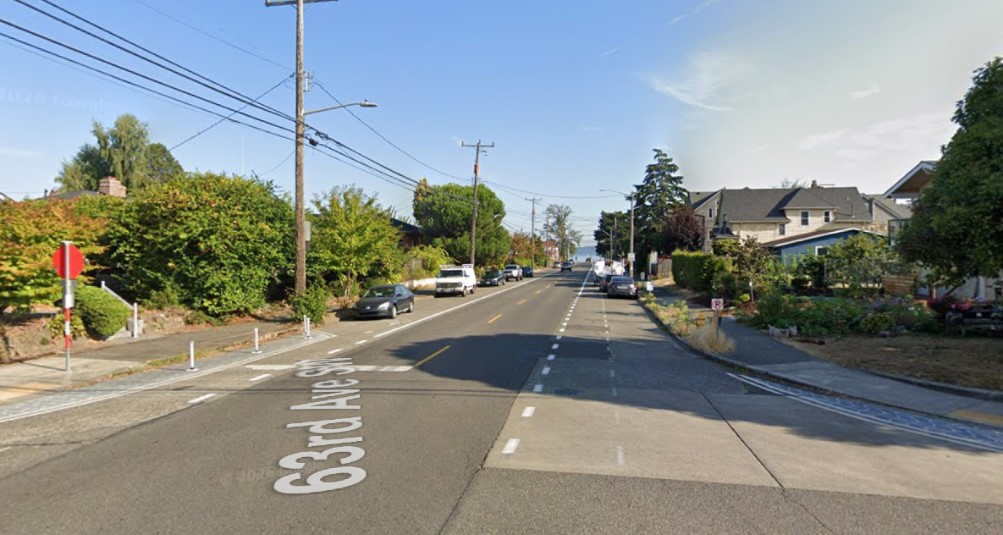 (Google Maps image, looking north on 63rd from Admiral)
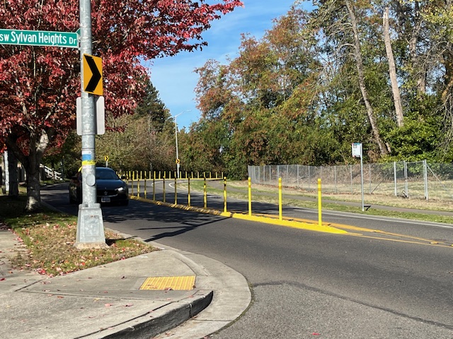
With all the traffic-calming features installed in the Alki area so far, including speed bumps across 60th, 61st, and 62nd, residents have asked why not 63rd too, given its use as a straightaway south of Alki Avenue. We asked SDOT again recently and got an answer today: It will get some too, though not any time soon. That answer came in connection with a package of other traffic calming, according to our response from SDOT spokesperson Ethan Bergerson:
We’ve been focused on traffic calming in the Alki neighborhood and recently installed speed cushions on 60th Ave SW, 61st Ave SW, and 62nd Ave SW to help reduce speeding on nearby north-south streets.
We’re planning to extend similar treatments to 63rd Ave SW between SW Admiral Way and Alki Ave SW, with installation anticipated as early as next year.
Separately, additional traffic calming improvements are under consideration along Alki Ave SW between 58th Ave SW and 63rd Ave SW through the District Project Fund. These could include speed cushions, raised centerlines to encourage slower turns, and intersection visibility upgrades. These proposals are not yet finalized and will ultimately be decided by the City Council.
We also asked about the status of the flashing beacons at 63rd/Beach Drive, where the poles have been up, waiting the lights, for months now, and Bergerson says it could be months more: “We are still awaiting equipment and will move forward with installation once materials arrive, which we expect in the coming months.”
SIDE NOTE: District 1 City Councilmember Rob Saka and his staff released a sheaf of updates on other transportation projects this afternoon; we’ll have a report on those later toight.
In 2007, SDOT removed a marked crosswalk on Fauntleroy Way at SW Rose Street, mid-Lincoln Park.
Community members long lobbied to bring back a safer crossing, and SDOT long said they couldn’t/wouldn’t.
Then the department relented, and last year unveiled a design that was far more complex than a crosswalk, including a raised median between the ferry holding (outside southbound) lane and travel lanes. Here’s what they showed at the time:
 (SDOT-provided 2025 renderings above and below; see PDF versions here)
The Fauntleroy Community Association and Morgan Community Association have voiced concerns about the design, a regular discussion topic at recent meetings, and want to know what you think, so they have just announced a community forum with SDOT for this Wednesday (May 6), 5:30 pm at Southwest Library (9010 35th SW).
Just announced by SDOT, a two-day closure of the West Seattle “low bridge” – officially the Spokane Street Swing Bridge – to drivers during the weekend of May 16 and 17. Here’s the announcement we just received:
Starting Saturday, May 16 and continuing through Sunday, May 17, 2026, the South Spokane Swing Bridge (also called The Low Bridge) will be closed to all vehicle traffic for the weekend. However, people on bicycles and walking will still be able to use the bridge, with possible delays associated with bridge openings for boat passage and as part of the maintenance work. During this time, crews will replace the tail lock cylinder, motor, and hydraulic pump.
(SDOT photo: Tail lock shaft on the approach-bridge side that is extended into the swing span to lock the structure together)
What you need to know:
The bridge was built in 1991 and serves as a crucial link across the West Duwamish Waterway, especially for people walking, rolling, and biking.
Planning, design, and construction for the initial phase of the Spokane St Swing Bridge Rehabilitation Program took place from 2020 to 2022.
The work taking place May 2026 will be to replace the motor, pump, and tail lock cylinder on the west side of the bridge. … Work on this project, which includes other ongoing maintenance, is expected to continue throughout 2026.
We checked in with SDOT three weeks ago for an overview on work like this that’s still on the way.
Washington State Ferries has been saying it expected the Fauntleroy-Vashon-Southworth run to return to three-boat service in “late April.” It’s missing that by just a couple days; WSF announced today that full service will resume on the route this Saturday, May 2.
Three Washington State Ferries notes:
TECH TROUBLE TODAY: WSF reports a “network outage” affecting ticket sales right now:
A network outage is affecting point-of-sale systems and the online ticket store. Fares are being processed offline at terminals. This may cause longer transaction times and delays through the tollbooths. Customers are encouraged to allow extra travel time.
2:59 PM UPDATE: WSF says this is fixed.
FARE, PASS CHANGES FRIDAY: Speaking of tickets, on Friday, May 1, WSF will implement these three changes:
-Passenger and vehicle ticket prices will increase by an average of 3%. The Washington State Transportation Commission approved these changes last summer.
-A 35% peak season surcharge for single-ride vehicle and motorcycle fares will begin May 1 and last through Sept. 30. It does not apply to passenger and multi-ride tickets.
-We’ll start a pilot to extend the expiration date for multi-ride passes. For multi-ride passes purchased on or after May 1, they will be valid for 120 days, up from the current 90 days.
PET POLICY UPDATE AND MORE AT SPRING ONLINE COMMUNITY MEETINGS: We’ve been tracking the pilot program to loosen pet policies aboard ferries, and WSF announced today it’ll update that policy at its spring community meetings, which are scheduled online at noon and 6 pm on Tuesday, May 26. You can register now for whichever time spot you prefer; both meetings routinely have lots of time for Q&A, submitted either in advance or during the meeting. Registration links are in our calendar listing.
Two weeks into the repaving project on SW Barton in the bus-layover zone along the north side of Roxhill Park, SDOT is providing a progress report. This week, crews excavated beneath the street, digging up dirt and concrete, with an archaeologist overseeing the process. Here’s what SDOT says is up next:
Next week (April 20–23), we’ll prepare the newly trenched area to be filled with lightweight cellular concrete after excavation is complete.
On the week of April 27th, we’ll fill the trench with lightweight concrete. Since the area is above a peat bog with challenging soil, this concrete will support buses and regular traffic without environmental impact, according to SDOT’s Environmental Team.
… If you have any questions or concerns during the project, our team is here to help. You can contact us by emailing SWBartonLayover@seattle.gov or calling 206-400-7570.
SDOT says the work is likely to last until fall. Until then, buses that normally travel on SW Barton are using SW Trenton; the project website has the map and details.
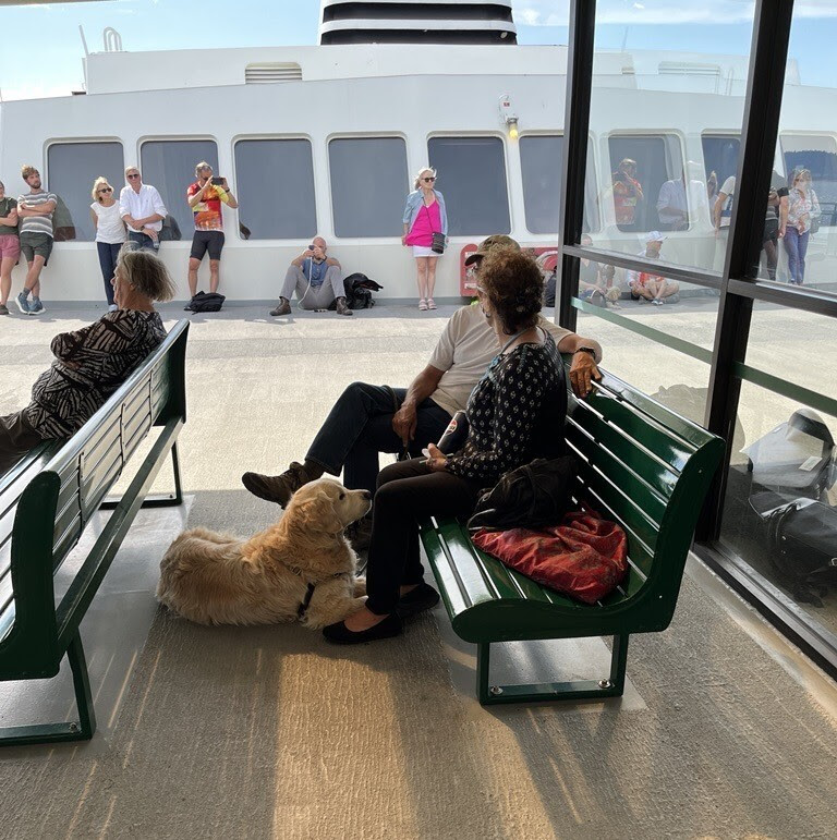
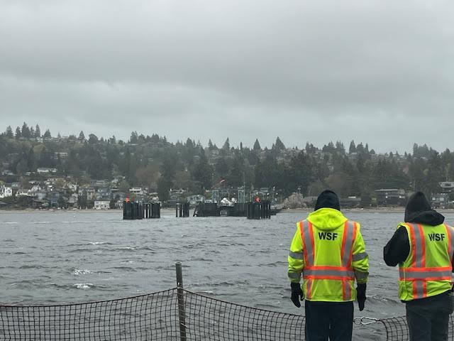 (Vashon sailing approaching the Fauntleroy terminal, Tuesday)
By Anne Higuera
Reporting for West Seattle Blog
Ferry service for all riders could see some temporary improvements under Washington State Ferries’ plans to adjust while the FIFA World Cup soccer matches and events are held in locations around the Seattle area this summer.
WSF released the annual Service Contingency Plan, as they have for the last several years, outlining progress, challenges, and a framework for how to provide service when something goes wrong. This year’s plan includes a temporary increase to staffing and decrease to response times to breakdowns when they happen during FIFA. One of the keys to making this happen is that maintenance is being scheduled to minimize the number of boats out of service at the same time.
Seattle is a host city for the 2026 FIFA World Cup. Six matches will take place in Seattle, and the region will see significant visitation associated with the event. There are nine “Fan Zones” in Washington state, including one in Bremerton, where fans can gather to watch matches and celebrate. In addition, seven matches will occur in Vancouver, British Columbia, and significant travel between Seattle and Vancouver is expected. We will make several adjustments to our normal contingency framework during the World Cup:
1. Relief vessels. We will have 20 of our 21 vessels available for service during the six weeks of the tournament. With 18 vessels needed to maintain full summer service, this means we will have two vessels available in relief in case a vessel must be removed from service. This will provide us with the flexibility to deploy an appropriate relief vessel if needed. These vessels will be docked at our Eagle Harbor Maintenance Facility.
2. Additional vessel crew. We will have additional crew on standby at Eagle Harbor, where our relief vessels will be positioned, allowing quick response to any vessel-related issue in Central Puget Sound.
3. Additional terminal staff. We will have additional staff at terminals to assist passengers and manage crowds.
4. Relaxing of the “24-hour rule.” Because we will have relief vessels available, and to maintain service on Central Puget Sound routes where the heaviest event-related ridership is likely to occur, we may respond to issues more quickly by deploying a relief vessel. This includes the Seattle/Bremerton, Seattle/Bainbridge Island, and Edmonds/Kingston routes.
The “24-hour rule” usually means a replacement vessel is not assigned until a route is missing a boat for that time frame. The change may mean faster resumption of schedules on routes closest to Eagle Harbor on Bainbridge that have maintenance issues, though response time to the San Juan Islands is still about 6 hours.
This year’s plan pointed to an increase in ridership on the Triangle Route (Fauntleroy-Vashon-Southworth) of 4.7% over the previous year, and included a graph of average loading numbers from a single week in last November when the route had 2 vessels instead of the regular 3. The report said this is the type of data WSF uses to make service decisions. The system overall reached 20.1 million riders in 2025 for the first time at that level since 2019, and 5% more than in 2024. That was accomplished in part by an increase in hiring that made it possible for an additional 7,000 sailings, while cancelling 400 fewer than the previous year.
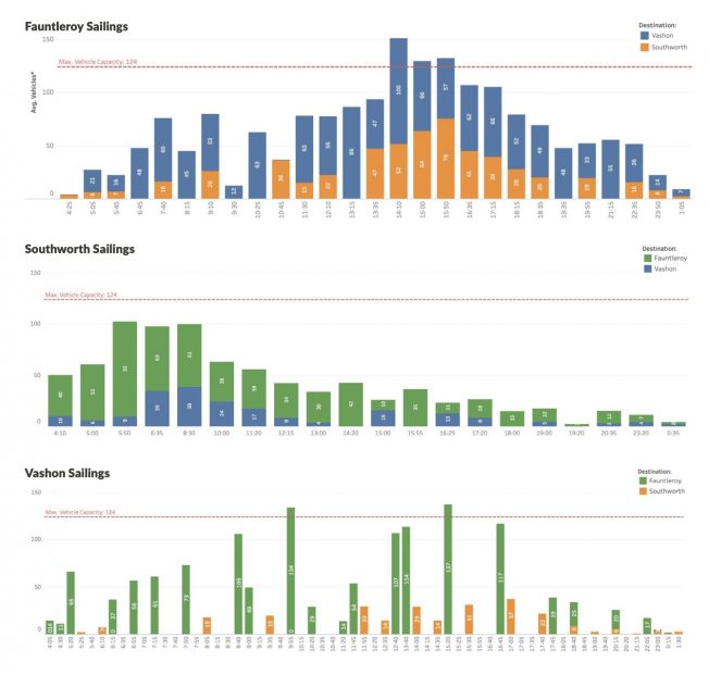
(Average number of vehicles loaded per sailing, week of Nov. 3, 2025)
Another new feature of the contingency plan this year is the “Terminal Contingency Framework,” which outlines most likely steps in the event that a terminal is out of service—either briefly or longer-term—while something is fixed. For the Fauntleroy dock, that is, “No service until repaired or consider moving service to Seattle.” For Southworth, it’s the same with a possibility of moving service to Bremerton. Vashon, with 2 slips and a spot on the dock where a boat is tied up overnight, has more complicated solutions: “If a vehicle slip fails, use other vehicle slip but there will be delays when vessels conflict. Will need alternate for overnight tie-up if one slip is not available.”
The service plan also provided an update on the hybrid-electric ferries that WSF has contracted to have built at Eastern Shipbuilding Group on the Gulf Coast of Florida. They are expecting steel to start being cut for the first boat this summer, with completion in 2030. The plan notes, “With limited vessel availability, we will be unable to operate full service on every route until new vessels are constructed and delivered.”
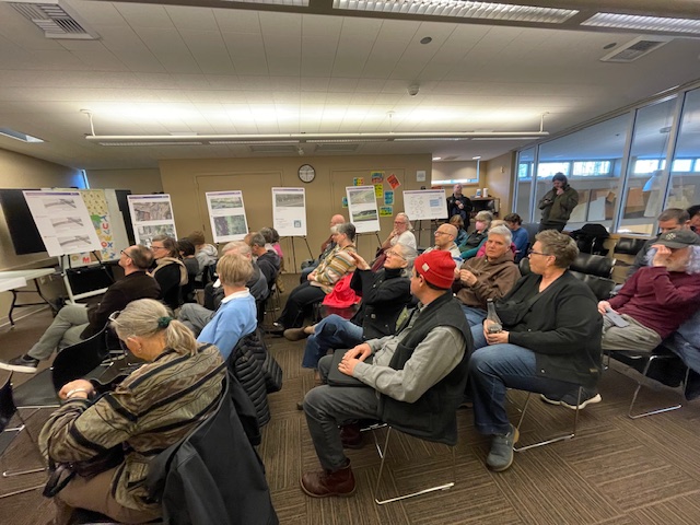
By Jason Grotelueschen
Reporting for West Seattle Blog
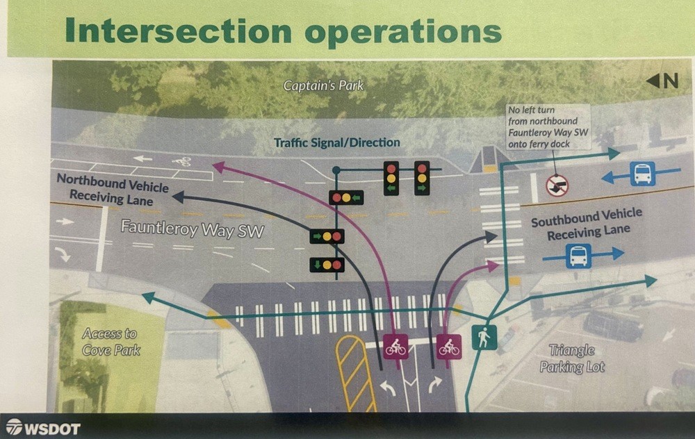
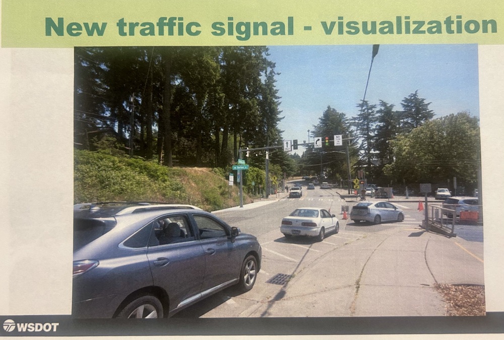
 The Fauntleroy Community Association board met on Tuesday night at the Fauntleroy Schoolhouse for their April meeting, chaired by FCA president Frank Immel and featuring several updates in addition to special guests from Washington State Ferries talking about plans for the new traffic signal scheduled for installation starting this fall at the Fauntleroy Ferry Terminal.
Meeting summary below:
SPD UPDATE: Crime prevention specialist Matt Brown and community service officer Jamie Heslin from the Southwest Precinct were in attendance to give an update, starting with some statistics:
Brown also noted that he followed up on the FCA’s board’s request from their March meeting to see if SPD can provide neighborhood support to help ease the potential “traffic nightmare” from the “dueling construction projects” planned for the area in a similar timeframe, including:
Brown said that requests for traffic support have been filed and that the SW Precinct captain (Krista Bair) is “definitely taking this seriously.” As Brown and Heslin departed the meeting for their next commitment, board members expressed gratitude for the support and action.
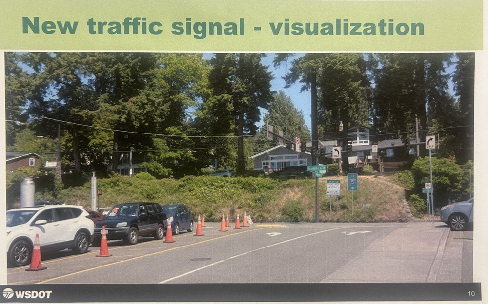
FERRY TERMINAL TRAFFIC SIGNAL: Next up was an update from WA State Ferries external relations director Hadley Rodero (who also lives in West Seattle) and Charlie Torres who serves as the project manager overseeing the design of the Fauntleroy Ferry Terminal. The team provided an update on the new ferry dock intersection signal installation planned for fall 2026, and they explained the design, safety features, and how it will be maintained by SDOT with the timing of the signals adjusted based on performance data.
The team brought some updated visuals and renderings to share, including an overhead view of the new signals:
From Fauntleroy Way SW looking south:
From the ferry dock, looking east:
As well as the view from the bluff across the street, which has a lookout area known as Captain’s Park:
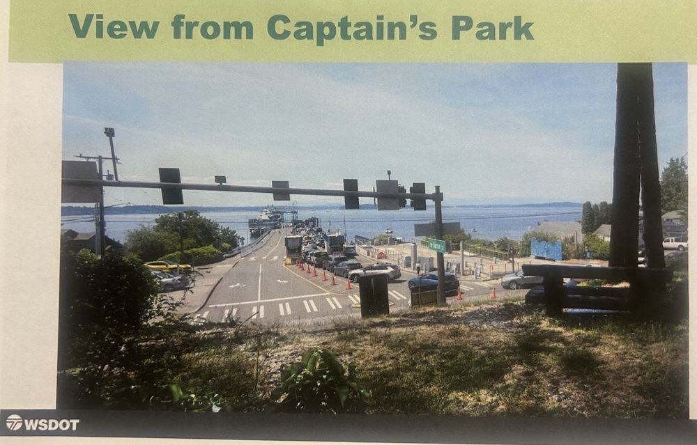
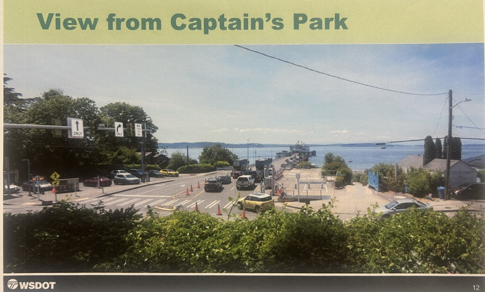
The team expects to award the construction contract in June, and construction work is scheduled to begin after September 8th to avoid the summertime “high season” rush as well as a construction moratorium related to the World Cup. The project will involve 3-4 months of construction work (which puts likely completion in late 2026 or early 2027). The signal will have sophisticated light controls designed to manage vehicle flow in different directions, with pedestrian safety being a key consideration. Rodero said there are plans to do extensive outreach to ferry customers and neighbors to provide information about the new system before it goes live. Torres said the signal is necessary due primarily to too many “close call accidents” in the area, as well as needing to improve overall traffic flow and efficiency with loading/unloading the boats.
FCA board members generally expressed support for the initiative but asked again about the aforementioned “dueling construction projects” in Fauntleroy, of which the new signal is one of them. The team acknowledged the challenges and agreed to have WSF representatives in attendance at FCA’s September board meeting (by that time, a contractor for the signal installation will have been selected and will likely be getting started), and again at the Fauntleroy Fall Festival in October to answer questions from the general public. The group also explored options for community engagement around the multiple related projects, including potential collaboration with the Rose Street crossing project, and potentially developing a community advisory group for the next environmental review phase.
Other points of Q&A:
FOOD FEST RECAP: FCA’s David Haggerty and Reed Haggerty, along with other FCA board members, talked about the group’s successful annual meeting and Food Fest event last month (WSB coverage here). There were over 175 people in attendance, and 21 vendors. There were 40 renewals of annual FCA dues, and 12 new households joining FCA. Feedback about the event was positive from vendors and attendees alike. Board members discussed strategies and ideas for future Food Fests and events.
FCA FINANCES: Treasurer Alan Grainger presented the group’s financial report, noting that dues and contributions from the annual meeting and Food Fest exceeded expectations, and highlighted the progress toward business member support goals. As of the beginning of April, the group is 46% of the way toward its annual goal for incoming contributions, thanks to the bump from last month’s Food Fest and egg hunt.
FALL FESTIVAL PREPARATION: Related to finances, the group also discussed fundraising for the group’s other big annual event, the Fauntleroy Fall Festival (scheduled for Sunday October 18). To raise funds between now and then, there are several events planned, including:
ROSE ST CROSSING: Immel noted that he had talked again with SDOT’s Ching Chan about the Rose St crossing project (involving pedestrian-operated flashing signals and a bus stop design with an island), and said that she wants to put together a joint community meeting with FCA and MoCA (Morgan Community Association) about the project, as a next-step. Details about that meeting are TBD.
OTHER FCA BUSINESS:
The FCA Board meets ten times per year on the second Tuesday of each month, at 6 pm in the Fauntleroy Schoolhouse board room. Meetings are open to the public.
 (Cascade Bicycle Club photos)
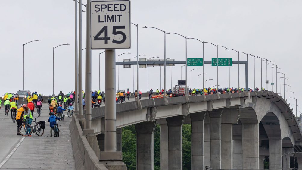
As we’ve reported previously, Cascade Bicycle Club is bringing back the Emerald City Ride this year on April 25, on a route including the westbound West Seattle Bridge. They’re sponsoring WSB right now to amplify the ride, with one week left to register – here’s their message!
Who We Are
Cascade Bicycle Club is the nation’s largest statewide bicycling nonprofit, serving bike riders of all ages, races, genders, income levels, and abilities throughout the state of Washington. We teach the joys of bicycling, advocate for safe places to ride, and produce world-class rides and events!
What We Do
Our signature programs include the Seattle to Portland, Free Group Rides, the Pedaling Relief Project, Your Streets Your Say advocacy training, the Bike Walk Roll Summit, Let’s Go, and the Major Taylor Project.

Emerald City Ride
Register for our upcoming Emerald City Ride and see Seattle by bike from a state highway! We’re taking over southbound SR-99 and the westbound West Seattle Bridge for an early morning spin around Alki and a jaunt south to Fauntleroy. This 20-mile ride offers a car-free experience for the first three and a half miles and takes you past some of the best lookout points and views of the Seattle skyline and Puget Sound’s islands.
Ten miles of nearly flat terrain transforms into a hill climb up from the Fauntleroy Ferry Terminal. Riders are rewarded with a gradual downhill grade through Delridge on the return to downtown Seattle via the low bridge.
Come celebrate the return of the Emerald City Ride, which has been on pause since 2024.
Event Details
Date & Time: Saturday, April 25, 2026, 7:00 – 11:00 am
Location: S. Charles Street near Lumen Field Event Center | South Charles St, Seattle, WA 98134
Price: Varies, see registration (base registration $50-65)
Distance: 20.1 Miles
Elevation Gain: 965 Feet
Family friendly after-party at Lowlander Brewing starts at 10:30 am!
Additional details including FAQs, parking/transit, food breaks, ride support, etc. can be found on the Emerald City Ride Event Page.
Online registration closes on Thursday, April 23 at 11:59 pm. There is no registration available at the start line.
Join Our Community
Cascade Bicycle Club brings people together to experience the joy of bicycling through transportation, recreation, and friendship. We collaborate with members, volunteers, and community partners to inspire people to advocate for a safe, equitable, and sustainable Washington state.
We envision a safe and healthy future where bicycles bring people together, eliminate inequity, and create thriving communities. Join us on wheels or as a volunteer for the Emerald City Ride, and at any of our future ride events!
We thank Cascade Bicycle Club for choosing to advertise the Emerald City Ride by sponsoring independent, community-collaborative neighborhood news on WSB. Interested in joining our sponsor team? Please email WSBAdvertising@wsbsales.com for information – thank you!
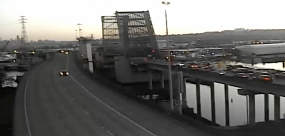 (Tuesday morning WSDOT camera image of stuck-open NB 1st Avenue S. Bridge)
And now we have followup information on Wednesday morning’s two-hour-plus northbound 1st Avenue South Bridge stuck-open problem. WSDOT spokesperson RB McKeon tells us it was electrical trouble, “fixed after an electrical engineer with advance knowledge of the electrical systems of the bridge arrived on site and was able to troubleshoot and repair the issue.” So that’s separate from the cracking that led to the need for repairs last month. Speaking of which, we also asked if the date is set yet for Phase 2 of those repairs – since it wasn’t when we published this report last week following a briefing given to a City Council committee. McKeon’s reply: “We do not yet have a start date for the Phase 2 repairs, but we are still tracking sometime at the end of April/beginning of May.”
With the recent troubles for the state-owned 1st Avenue South Bridge – the bridge-decking cracks, then the mechanical trouble this week (still pursuing followup questions about that) – we wondered about the city-owned West Seattle low bridge’s status. It’s had various maintenance projects in the past few years, but still has periodic problems with the gates, among other things. So we asked SDOT if anything else was on the horizon for the low bridge (officially, the Spokane Street Swing Bridge). Short answer, yes. Long answer:
Our work to maintain and upgrade the West Seattle Low Bridge is ongoing. We have completed several major improvements over the past few years and are planning to continue working on additional upgrades to improve the bridge’s reliability and operations.
Over the past few years, we have completed several improvement projects including bridge strengthening work, earthquake safety upgrades, replaced and refurbished key mechanical components including the turn cylinders, upgraded the bridge’s control system, and installed an intelligent remote monitoring system.
In the near future, we plan to replace both vehicle barrier gates. We are waiting to receive the components for this project and do not yet have an exact estimate for when this work will occur. We will share more details about the schedule when we know more.
Other future projects in the coming years will likely include additional work on the bridge’s hydraulic systems and lock mechanisms and further improvements to the machinery that operates the bridge. We are in the process of designing this work and have not determined the exact timeline.
SDOT has just released a 62-page report with toplines on how it spent Seattle Transportation Levy dollars during the first full year of the eight-year, $1.55 billion levy approved by voters in 2024. We went through the report to look for West Seattle-specific mentions, and there weren’t many, since the report is more focused on categories of spending.
 (WSB photo, October 2025)
One relatively small West Seattle project does get a specific mention as “completed” – preventive measures (primarily median posts) in the “high-collision” stretch of Sylvan Way. Another West Seattle-specific project mentioned: The Highland Park Way hill lane-conversion project, described simply as a “protected bike lane,” is noted as “progressing in design.” (Also in design, outside West Seattle but often mentioned in WSB comments, the 4th Avenue S. bridge project over the railyard, where the outer northbound lane has been closed for years.) Maintenance work is mentioned too – page 27 features a photo of cleaning under the Fauntleroy Expressway end of the West Seattle Bridge, for example.
So how does this compare to what SDOT said it was going to do in year one? We reported on the 2025 plan in January of last year. That story includes a long list. Since the new report doesn’t get into many specifics, we can’t easily compare the two, but we recognize at least some of last year’s list as having been done (the Alki north-south streets that got speed bumps, for example), and you can probably identify more for the done/not done lists if they’re on routes you regularly use. As for this year’s plan – we reported on that in February, including this followup; we’ll see what’s indeed done by this time next year.
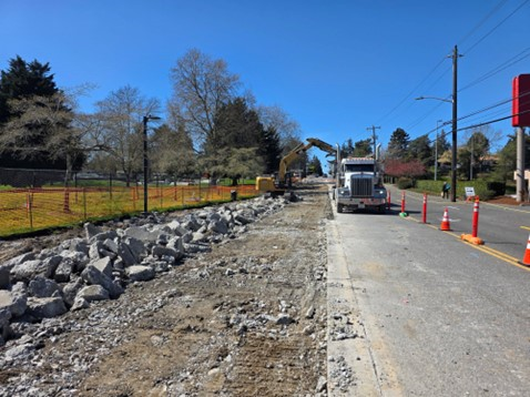
Thanks to the commenter who noted that the work has begun on SW Barton, on the fifth day after bus traffic was rerouted to Trenton and layovers to 25th SW. Previous communication suggested there might be more of a gap, but since this repaving-and-more work is scheduled to last until fall, the sooner they could get going, the better. Details of the project to rebuild the bus-battered pavement are here. As shown in our photo, the work is narrowing travel lanes on Barton alongside Roxhill Park and eastward to 26th, so plan accordingly if you’re headed that way.
Hard to see in the evening sun’s glare (sorry, got there at a bad time), but the sign in the middle – looking west on SW Trenton from just east of 35th SW – says NO TURN ON RED. SDOT has added that sign in many places but this is notable because it’s for the stretch of Trenton affected by the just-started rerouting of buses from Barton to Trenton. Nearby resident Juanita sent the tip:
FYI, a No Right Turn On Red sign has been added to the intersection of SW Trenton at 35th. Hopefully we can get a left turn signal installed on 35th making the turn onto SW Trenton. It wasn’t so bad over the weekend, but this morning was really touch and go when there was a 21 trying to make the right onto SW Trenton and back-to-back Cs trying to make the right.
Also, drivers need to be especially careful approaching the intersection of SW Trenton and 32nd. Yesterday we were getting ready to make the left turn onto 32nd and saw the C approaching at the last minute and were fortunately able to stop.
As we’ve reported, the traffic switch from Barton to Trenton is because of the repaving work that is scheduled to start soon in the bus-layover zone along the north edge of Roxhill Park. The rerouting started early so that it would coincide with Metro‘s spring “service change.”
Washington State Ferries has announced a milestone for the Fauntleroy ferry terminal replacement project. The next step is construction of the traffic signal where the dock meets Fauntleroy Way SW – above is a rendering of the intersection with the signal – but here’s what else is happening, as announced by system leader Steve Nevey:
Our Fauntleroy terminal replacement project has completed its planning phase. The Federal Highway Administration recently approved the final Planning and Environmental Linkages study, closing a five-year process of exploring options for replacing the terminal. Based on community feedback, we are moving forward with a design that adds more dock space and increases capacity from about 80 to 124-155 vehicles. This option also avoids impacts to nearby Cove Park, and we will continue refining the design to reduce effects on other sensitive areas. Later this year, the project will enter the National and State Environmental Policy Act phase. This is when we’ll begin preliminary design, complete environmental review and permitting, and continue seeking funding. Major construction is expected to begin in 2028. The new terminal is expected to open around 2031.
WSF says the signal construction, meantime, is expected now to start this fall. Also happening right now, the state is in the permit process to convert the beach house immediately north of Cove Park into an office for the project, among other potential uses.
By Tracy Record
West Seattle Blog editor
SDOT‘s contention is that converting a downhill lane on the Highland Park Way hill will make the road safer.
“For bikes or cars?” asked an attendee at last night’s HPAC meeting, loudly.
“For people!” retorted another attendee.
HPAC – the community coalition for Highland Park, Riverview, and South Delridge – has long been asking SDOT for an in-person meeting to answer questions about the lane-conversion project, which is fiercely opposed by drivers who say removing a driving lane will lead to traffic jams on one of the few ways out of West Seattle. Last night, they got that meeting. Judging by various bursts of applause and jeering – which HPAC co-chairs Kay Kirkpatrick and Barb Biondo tried to discourage – that viewpoint dominated among the 50+ people who filled the Southwest Library meeting room, but at least a few supporters were present too.
SDOT has remained resolute that driving-lane removal is not up for debate, but other aspects of the project are. Earlier this week, they unveiled another option for configuring the bottom of the hill, where Highland Park Way meets West Marginal Way. Before that, they announced they would separate the converted lane from the vehicle lane via jersey barriers that could be removed in case of catastrophe like another West Seattle Bridge long-term closure requiring restoration of the second downhill lane. But that didn’t seem to placate those whose memories of the 2020-2022 bridge closure remain fresh. Two people even brought signs, one reading “Fix Existing Problems Before Creating New Ones.”
Last night’s meeting was held in three parts – first, SDOT reps recapped where things stood, then everyone was invited to engage them in conversation around the room, and finally a reconvening of the full room for questions/comments. We recorded the first and third parts on video. Here’s part one:
SDOT reps who spoke were project manager Tony Roberts, project engineer Luke Larson, and project communicator Dan Anderson. They opened by trying to clarify a statement made at the online meeting earlier this month, in which this was described as a “safety project” rather than a “bicycle project.” Yes, but, they said, the money – $4 million – comes from Bicycle Master Plan funding and Vision Zero. In addition, the bicycle lane is intended to address a gap in how riders can get from West Seattle to the Duwamish River Trail. Regarding the newly unveiled Option 2B for handling traffic at the bottom of the hill, SDOT feels that its configuration means two lanes aren’t needed to feed into it any more. Larson said they’d done “modeling” to verify this. They also intend to use plastic center-line posts (like Sylvan Way and Alki/Harbor Avenues) and a high-friction surface treatment – all that will be part of a separate project but concurrent with construction on the lane-conversion. They reiterated that putting jersey barriers on the center line is not an option because they need two feet of width.
When the time came to circulate, about half the attendees did, while the other half stayed in their seats until the full-group session – here’s our video of that:
One of the first to comment declared, “You need to give precedence to the cars over the bikes, I’m sorry.” Anderson acknowledged “this is where we get into disagreement … there’s a lot of expertise … we feel with this it will still work OK.”
In the face of repeated contentions that “this will make it worse,” he insisted, “We don’t believe it will.”
The “what if the West Seattle Bridge goes out?” question also repeatedly arose. Larson said the jersey barriers could be removed to reopen a car lane “within a couple of days.” Anderson also tried to use this to reinforce that SDOT had listened to feedback on some points, saying that SDOT did not expect feedback to include “what if the West Seattle Bridge goes out?”
Another attendee declared, “You’re not solving the crashes – you need to separate the downhill and uphill. Put in some trees like you did on Delridge.”
Then, the question, why not improve the existing sidewalk on the downhill side?
“There’s not room,” said Larson, saying it’s six to eight feet now but they need 10 to 12 feet, adding that the steep dropoff from the existing sidewalk would require “tens of millions of dollars (to be spent) on retention walls.”
A man who spoke in favor of the lane conversion said he’s biked up Highland Park Way “100 times, and downhill maybe once” because of the bumpy path. When this is built, he said, he can put his kids on a bike and ride to South Park. “I will not be driving that street in the future if I can ride the street safely” – one less car, he noted.
A number of concerns were raised by people who live on Othello, a southward turn off the hill. Anderson said SDOT would come out to talk with those residents before long. He also acknowledged that the concept of adding a traffic signal there was mentioned at the meeting, though it hadn’t come up previously.
The SDOT replies to concerns didn’t win over the doubters. One concern about “so much road rage” on the hill was met with a reply that it would be less prevalent with one lane of traffic, if you’re only looking at a car directly in front of yours. That drew derisive hoots.
If the goal is to slow drivers down, why not speed bumps? someone asked. Larson said they’re generally not installed on slopes steeper than eight percent – HP Way is 11 percent.
What about a speed camera? someone else asked. Short answer: That would have to be enabled by state law (which currently limits speed cameras to school zones; the HP Way hill is not part of one).
What about widening the path on the uphill side? Kirkpatrick reminded everyone that the uphill side has had slides, and trees fall fairly frequently.
The SDOT team kept trying to reassure the room that they had “looked at a lot of concept.” Larson mentioned Alki and Green Lake. Those are flat, someone countered. Yet another attendee who described himself as “the most seasoned cyclist in Highland Park”
“By reducing the number of lanes, you’re reducing our quality of lives!” someone said. Another: “This plan is pitting drivers against bikes, but we should be working together.” Another: “This is planning for the future.”
Meantime, alternatives were suggested. Rumble strips? Turtles?
One person also noted that Highland Park has been saddled with a lot over the years, dating back to the municipal-jail proposal that HPAC fought tooth and nail more than a decade and a half ago, and multiple encampments, both RVs and tents, not to ention the future Glassyard Commons tiny-homes-and-RV-lot site close a short distance east of the Highland Park Way hill.
Another tried a final line of questioning: “Is there a date by which you have to spend the funding for this?”
SDOT didn’t really answer that, but Roberts noted that construction is currently set for next year.
| 23 COMMENTS