West Seattle, Washington
04 Saturday
Tomorrow will mark one week since mechanical trouble closed the West Seattle low bridge to road and path users. Tonight, some updates, starting with a map for the bicycle detour:

“This is a long detour,” SDOT acknowledges in this post about options for getting around while the low bridge is out of service, adding “We have been working this week to clear recent windstorm debris from the route, install detour route signs, and review the asphalt condition to see if spot improvements can be made to support riders.” Also of note, SDOT says, “Should the closure extend much beyond two weeks, we’ll consider other options for enhancing travel without a car.” (Back during an emergency low-bridge closure in 2018, a shuttle was implemented.)
So how long might the closure last? Still no estimate. SDOT spokesperson Ethan Bergerson told WSB today, “Crews have been in the bridge every day since the recent incident, working to create a repair plan and timeline. We haven’t finished our analysis yet, but this is a high priority and we are working to fix the bridge as fast as we can.” SDOT also has published a recap of work that had already been done on the bridge, and what was planned – including this photo of work back in October:

Most of the low-bridge work was part of the same contract under which Kraemer North America repaired the high bridge. Looking into our archives, this July report projected that much of the low-bridge work was at the time expected to be done by year’s end.
 Saturday, for New Year’s Eve, many transit services around the region will be fare-free, including the West Seattle Water Taxi. The annual announcement just arrived – here are the Seattle/King County highlights:
*King County Metro: Buses will operate on their regular Saturday schedule and be fare-free from 3 a.m. Saturday, Dec. 31, through 3 a.m. Sunday, Jan. 1. Other Metro services operating fare-free include DART, Via to Transit, Ride Pingo to Transit, Community Van, and Access service. Please note Via to Transit will only operate until 2 a.m. Sunday, Jan. 1.
*King County Water Taxi: The water taxi will operate fare-free on Dec. 31 but will be out of service on Jan. 1. and Jan. 2.
*Sound Transit: Link light rail and Sound Transit Express buses are fare-free from 4 a.m. Saturday, Dec. 31, to 2 a.m. Sunday., Jan. 1. Sound Transit will operate extended Link light rail service on New Year’s Eve, with 15-minute, late-night service. The last southbound trip will leave Northgate Station at 1:58 a.m. The last northbound train will leave Angle Lake Station at 1:41 a.m. For more information go to the Sound Transit website.
*Seattle Streetcar: Both streetcar lines will operate Saturday service hours. The South Lake Union Streetcar will operate on New Year’s Eve until 12:30 a.m. to accommodate fireworks viewing downtown.
Note that the Water Taxi will run its regular Saturday schedule – no late-night sailings in fall/winter. And note that exceptions to the fare-free plan include the Seattle Monorail, which the announcement says “will collect regular fares and is scheduled to operate from Westlake to the Seattle Center until 11 p.m. on New Year’s Eve. After the evening’s events at Seattle Center, service to Westlake will run from 12:30 a.m. to 1:00 a.m.”
We’re adding this info to the WSB West Seattle Holiday Guide, where we’re also building a list of local NYE/NYD events – not too late to add one – westseattleblog@gmail.com – thank you!
 (SDOT camera image, looking west from east end of low bridge)
SDOT is finally commenting on what’s wrong with the West Seattle low bridge (Spokane Street Swing Bridge), four days after it was closed. According to SDOT, the bridge won’t reopen for at least two weeks because crews need “to repair mechanical issues that intensified after a power outage during the ice storm on December 23.” They’re still working on a “repair plan and schedule.” Here’s their explanation of what’s wrong:
The problem initially appeared to be associated with a computer issue that occurred while the bridge was powering back up after a power outage. Once the computer issue was resolved, engineers found previously identified minor issues with the hydraulic system that moves the bridge had intensified.
SDOT completes regular inspections of the Low Bridge and had existing plans to repair these aging components in 2023. However, after the power outage, it was discovered that previously manageable small-scale issues had escalated into more severe problems. Until these components are fixed, the bridge cannot be reliably moved without risking more severe long-term damage.
SDOT engineers are working as quickly as possible to analyze repair options. While there is not yet an estimate for how long bridge repair will take, SDOT expects the closure to last for at least two weeks.
Based on the evaluation results, additional Low Bridge closures for repairs may be needed in 2023, along with closures associated with planned capital improvements to the bridge next year.
In the meantime, the low bridge is being kept open for maritime traffic, but closed to vehicle, bicycle, and foot traffic. The bridge is 30 years old.
Metro says it’s going to change its service plan to the Emergency Snow Network on Friday. From the announcement just sent::
With ongoing freezing temperatures and a widespread freezing rainstorm forecast for the region, King County Executive Dow Constantine directed Metro to shift bus service to the Emergency Snow Network starting Friday, Dec. 23. The move focuses service on 65 core bus routes operating on snow routes that the City of Seattle and other jurisdictions prioritize for snow and ice removal. The Emergency Snow Network (ESN) will be effective at 4 a.m. Friday, Dec. 23, until 4 a.m. Saturday, Dec. 24.
This approach delivers transit service for the most riders and on streets and highways that are more reliably treated during adverse weather. Customers will be able to board service on 65 core bus routes and shuttles prioritizing higher ridership routes, avoiding steep hills and primarily serving key arterials and transit centers. The routes were developed in coordination and collaboration with jurisdictions, including the City of Seattle.
Metro will continue to operate all service on snow routes Thursday, Dec. 22, until switching to the ESN early Friday morning.
Routes operating as part of the ESN will serve core centers around King County, via RapidRide A, B, C, D, E and F lines, routes 3, 4 (between Seattle Center and Downtown Seattle only), 5, 7, 10, 21 (local service only), 24, 27 (snow shuttle only), 31, 32, 36, 40, 44, 45, 48, 60, 62, 65, 67, 70, 75, 90 (downtown Seattle/First Hill snow shuttle) 101, 105, 106 (between Renton Transit Center and Mount Baker Transit Center only), 120, 124, 128, 131, 132, 148, 150, 160, 161, 165, 168, 181, 184, 230, 231, 239, 245, 250, 255, 271 (between University of Washington and Eastgate only), 331, 345, 348, 372, 522, 545, 550, 554, 631 (if road conditions allow) 773/775 (if Water Taxi is running), 903, 906, 907 and 930.
Metro staff will be monitoring the performance of this network and making adjustments as needed to improve operations. Customers in outlying areas and neighborhoods should prepare for reduced or temporarily unavailable bus service due to inclement weather, difficult travel conditions and topography.
For the rest of today, Metro continues on snow routing, with cancellations/suspensions as announced.
 (WSB photos)
Even before starting his job, SDOT‘s new director Greg Spotts (above left) invited people from neighborhoods around the city to ask him to visit for “listening tours” – and the Fauntleroy Community Association did just that. This morning, Spotts made good on his promise, despite the snow (he’d originally been booked to visit a few weeks ago, but even snowier weather forced a postponement). He and SDOT’s interim transportation-operations director Dusty Rasmussen spent more than an hour getting a firsthand look at some of Fauntleroy’s transportation challenges, which the FCA has long been nagging the city about. The tour started in the north Lincoln Park parking lot, where Spotts declared that he’s passionate about streets along parks, observing that this particular park entrance isn’t particularly welcoming to “non-vehicle arrivals.” FCA president Mike Dey talked about the ferry traffic that queues up in the afternoon and on weekends, and how some drivers flout the rules that are. supposed to keep the parking lane clear during peak hours. Others pull midblock U-turns and there was talk of whether a hardened center line might prevent that. Crossing Fauntleroy is a challenge at some spots along the park, too.

From the park, they headed southbound on Fauntleroy to the ferry dock, where the main challenge happens in bursts – getting 120 vehicles (the capacity of the ferries usually on the route) out at a time. A public-safety officer is there to direct traffic some of the time; there’s also been talk of a signal, though Dey noted that the FCA doesn’t support that. He also mentioned the planned terminal/dock replacement, and a quarter-century-old city resolution opposing expansion of the dock. Continuing south, next stop was the Endolyne business district.

There’s been some traffic calming here, after previous pushes by the FCA – more pedestrian features have been applied to the 45th/Wildwood intersection, and 45th has some speed humps. One remaining major point of concern – the hill to/from Marine View Drive and chronic downhill speeding. Spotts observed that it “looks like a ramp.”

After a stop at Wildwood Market for warm beverages, the group was planning to continue eastbound to the Fauntleroy Church/YMCA/Schoolhouse stretch of California SW – which can be perilous for pedestrians. We had to drop out before then, with another scheduled event to cover. We did hear Spotts make one commitment along the way – he promised to come back in January/February for a better look at some of the conditions Dey had mentioned.
P.S. If you’re in Fauntleroy and want to get involved with the FCA, they meet second Tuesdays at the schoolhouse (9131 California SW), 7 pm; you can watch via livestream, too – info’s at fauntleroy.net.
The new city budget raises the fee for Restricted Parking Zone permits by almost 50 percent. SDOT notes that one RPZ neighborhood in West Seattle might want to renew a bit early to save money:
Readers who live in the Fauntleroy neighborhood [should] know about an opportunity to save money on their Restricted Permit Zone (RPZ) permit renewal.
On January 1, 2023, the new citywide budget will take effect and the fee for a two-year RPZ permit will increase from $65 to $95. Fauntleroy (Zone 3) RPZ permits will expire on December 31, 2022. Anyone who lives in this zone and renews their permit (or requests a new permit) in 2022 will be charged the current fee ($65). After January 1, permit requests will be processed with the new fee ($95).
Discounted $10 permits will continue to be available for people who are income-eligible. People with disabled parking placards / license plates do not need to apply for a separate RPZ permit.
Permit renewals should be made through the Seattle Services Portal to ensure they are processed on-time before the fee increase takes effect. Any questions about permits can be sent to DOT_RPZRequests@seattle.gov.
RPZ permits do not guarantee a parking space – they just guarantee the right to park during restricted hours, if you find a space.
 (Added image: Our inbox screen, filled with less than half-hour’s worth of Metro alerts since we published this story)
One week has passed since we first reported December 6th that Metro had taken 126 of its 1,500 buses out of service because of a steering “defect” discovered by drivers. (We reported the specific buses involved in this followup.) Metro was working with the manufacturer, New Flyer, to fix the defect. We asked Metro spokesperson Jeff Switzer how many have been returned to service so far: “We returned 3 affected New Flyer coaches to service using 3 new steering columns that were delivered by bus manufacturer New Flyer. We’re working closely with New Flyer on replacement parts and don’t yet have a timeline available.” In the meantime, trip cancellations, and in some cases temporary route suspensions, continue; the north West Seattle routes such as 56 and 57 have been particularly hard-hit. We asked Switzer why those routes and not some others with low ridership, for example, the 22. Here’s his explanation:
Routes 56 and 57 operate out of Central Base, where bus availability is temporarily limited; route 22 operates from South Base, which has more available buses. Routes 56 and 57 do have higher ridership than Route 22, but the majority of Route 56 and 57 riders have reasonable service alternatives. Route 56 riders are served by Route 50 and Route 128 connections to the C Line, or Route 775 to the West Seattle Water Taxi. Route 57 riders are served by Route 128 and the C Line, but there is a service gap in the Genesee Hill area south of SW Admiral Way and west of California Avenue Southwest. According to our ridership data, that route segment serves an average of 6-7 weekday riders. Route 22 is a lower ridership route, but also has limited service alternatives. The route provides unique connections to Chief Sealth High School and Southwest Community Center, and serves an equity priority community.
Metro says it’s currently operating 96 percent of its schedule, up from 90% shortly after the problem was disclosed.
A reader asked about this, and then we noticed it ourselves: Almost three months after the West Seattle Bridge reopened, the travel-time display on SDOT‘s overhead message boards still shows times for getting to the 1st Avenue South Bridge. Last week we asked SDOT why. Spokesperson Mariam Ali looked into it and sent this reply tonight:
We recently moved the Travelers Web Map to a more modern server. During this process the routes shown on our dynamic message signs were frozen so as to not further complicate the move. This work is complete. We are presently evaluating all dynamic message signs to see where routes should be modified or added. We expect to roll out new routes on the West Seattle Dynamic Message Signs and other locations the end of Q1 2023, if not sooner.
You can see what’s showing on the message boards around the city by going to the aforementioned Travelers Map and clicking “map controls” on the left side of the screen, then choosing “Travel Times”; the dropdown for Southwest will show you the Fauntleroy and 35th boards’ message for the 1st Avenue South Bridge.

When SDOT announced nine days ago that more speed humps would be added to part of Harbor and Alki Avenues, the agency also said it would install a raised center divider in the area, to deter people from trying to pass on the curve. Driving the waterfront street today for the first time in a few days, we noticed the divider has been installed. As our photos show, they have a feature that other sections of raised center divider in West Seattle – sections of Fauntleroy and Delridge, for example – don’t have: Posts atop the divider.

As promised by SDOT, which described the location as “between California Place and Luna Park,” the divider has gaps to allow turning to/from driveways. The speed humps and dividers follow years of community complaints about reckless and stunt driving in the area.
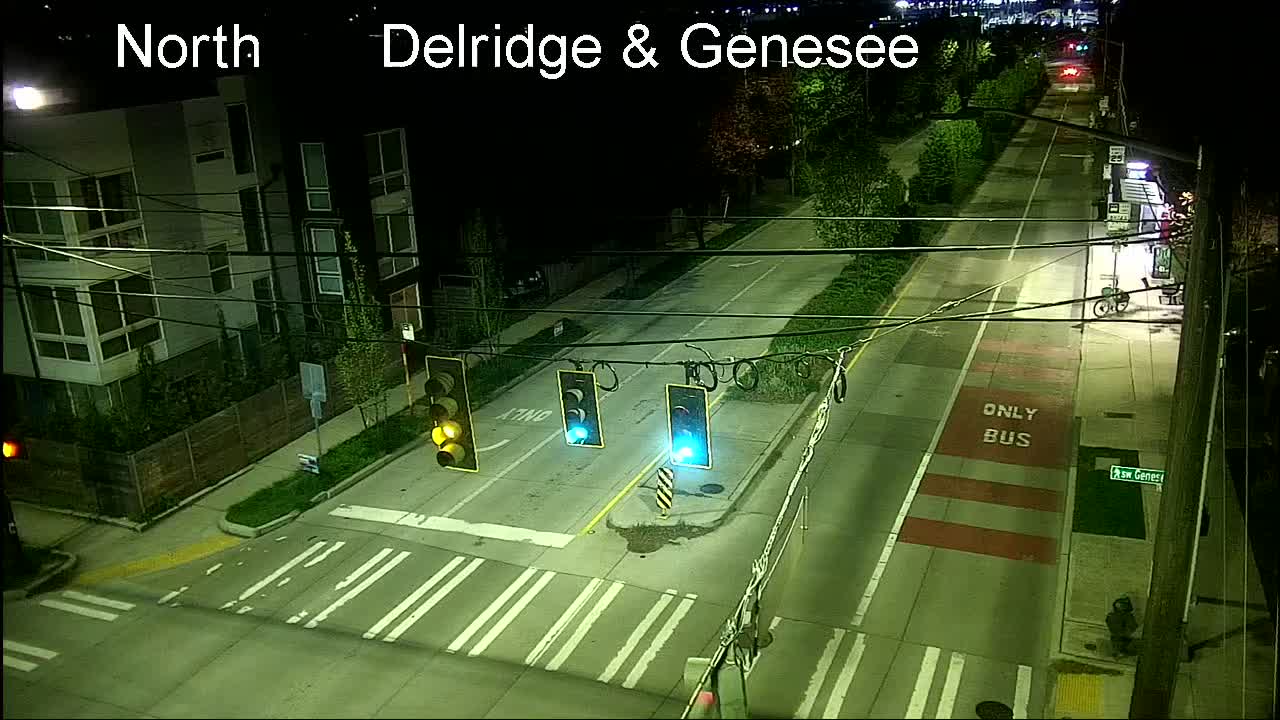
SDOT finally has traffic cameras for Delridge Way. We noticed them appear on the SDOT Travelers’ Map recently, but at the time they were only partially functional – no default still image, only visible if you chose “video” from the map windows; they’ve since become fully functional. They’re at Genesee (above), Oregon (1st below), and Orchard (2nd below), and SDOT tells us four more are planned.
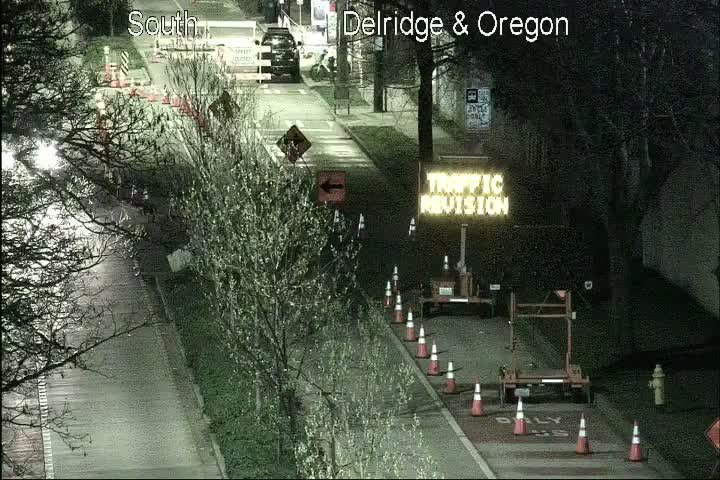
The next four, according to SDOT spokesperson Mariam Ali, will be at “Delridge Way SW & SW Henderson St; Delridge Way SW & SW Holden Street; Delridge Way SW & SW Juneau St; and Delridge Way SW & SW Thistle Street.” She says they hope to have those cameras operational by early February.
Still no word on whether or when a few key cameras that have been down for months – such as Highland Park Way/Holden and the second camera atop the high bridge – will return. (We keep asking.)
 (Beach Drive stretch of Alki Point ‘Healthy Street,’ photographed Saturday by Don Brubeck)
If you have something to say about the city’s “early design” proposals for the Alki Point “Healthy Street” – Beach Drive and Alki Avenue north of 63rd SW – the deadline is tomorrow (Friday) night. The city’s reminder summarizes: “We need your feedback on the design and project elements, including signs, landscaping, travel lanes, and traffic-calming tools like traffic circles and curb bulbs. While people can still drive on the Alki Point Healthy Street, the design has elements to discourage cut-through traffic and help keep the street safer for all users. This includes adding traffic circles, speed humps, bike lane markings, painted curb bulbs, vehicle turn-around areas, and crosswalk improvements. We’re also prioritizing ADA parking and loading zone areas for people kayaking, paddleboarding, and doing other water activities.” If you haven’t already seen the design proposals (WSB coverage here), go to this page. To comment by midnight tomorrow night, there’s an online form, or you can email AlkiKeepMovingStreet@seattle.gov or leave voicemail at 206-727-3565. The city announced in October that the “Healthy Street” status was permanent.
3:02 PM: In the wake of the removal of 126 buses from service – as first reported here last night – Metro has just announced it’s suspending some routes for the rest of today. They’re not all in West Seattle, but we’re publishing the full list in case others affect you off-peninsula: 9, 15, 17, 18, 29, 55, 56, 57, 64, 111, 114, 121, 125, 162, 177, 214, 301, 304 & 330. However, Metro adds this caveat, “Due to the fluid nature of the situation, a small number of trips may run on routes that are temporarily suspended.” Meantime, we’re still awaiting answers to some follow-up questions about the bus-removal situation.
4 PM UPDATE: Just got some answers, from Metro spokesperson Jeff Switzer. Regarding which buses specifically:
Out of 1,500 total buses, the New Flyer models affected include 39 of the Xcelsior 6200 articulated (60-ft) coaches in our fleet and 64 of the Xcelsior 8200 articulated (60-ft) coaches in our fleet. Those coaches have been temporarily pulled from service. We want to emphasize all of the coaches on the road have been inspected and confirmed safe. Additionally, there are a few other identified buses: two 3700 (35-ft) coaches, six 4300 trolleys, six 8000 articulated (60-ft) coaches, three 8100 articulated (60-ft) coaches and six 9600 articulated (60-ft) coaches.
Regarding how they’re deciding which trips to cancel/routes to suspend:
Per our usual practice, we’re prioritizing service on high-ridership trips, the first and last trips of the day, school trips and trips late at night. In some places peak commuter routes are being fully cancelled, and Metro is in process of developing information to provide on alternative routes for those customers.
Regarding how the repairs will be made:
This problem was only recently identified and we’re working closely with the manufacture to determine the best approach. The expectation is that some or all of the work will be done at our bases with the equipment supplied by New Flyer. There is no timeline yet for when the work will be completed.
First Metro had to deal with a staffing shortage. Now it has to deal with a temporary equipment shortage. We learned about this after a tip from Ian, who reported the driver on his RapidRide C Line trip late today made an announcement about a safety concern taking some buses out of service. We asked Metro about it, and they subsequently published this post, which explains:
… After two Metro operators identified a manufacturing issue in the steering system in some vehicles, Metro proactively removed 126 buses from service out of its 1,500-vehicle fleet. The identified problem did not lead to any accidents or injuries. Metro inspected all its buses to ensure all vehicles in service continue to perform safely and within specifications. We apologize and ask for your patience as some bus trips are being canceled and we adjust plans to keep you moving. …
The agency is coordinating with New Flyer, the manufacturer of the affected buses, who has already been on site to work toward resolving the issue. There is not yet a timeline for when the work will be completed and supply chain challenges may introduce delays. The defect does not extend to all New Flyer buses and many remain in service.
Metro advises using its planning tools to see how this might affect your trips.
 (WSB file photo)
Back in August 2021, the city announced it was considering removing the Delridge/Oregon pedestrian overpass instead of reinforcing it to make it more earthquake-resistant. Feedback opportunities ensued. Today, the final decision was announced – the bridge will stay, and will get a seismic retrofit. The announcement came in the newest email update on preparations for next year’s RapidRide H Line launch:
We will seismically retrofit the Delridge Pedestrian Bridge. Construction will begin in 2024.
The Delridge Pedestrian Bridge is a high priority for a seismic retrofit, which will make the bridge safer in events like earthquakes. Over the past year, we’ve been exploring whether we should remove the bridge or seismically retrofit it.
After we installed a community-requested crosswalk and walk signal as part of the Delridge Way SW – RapidRide H Line project at SW Oregon St, we considered if making the pedestrian bridge earthquake-safe and continuing ongoing maintenance was still the right approach.
Removing the bridge would save current and future costs. With the new signal and crosswalk offering a new way to get across the street, we thought community members might find the pedestrian bridge to be unnecessary.
However, Seattle’s older bridges continue to be used and often have interesting characteristics their neighbors have come to love.
Both options would improve safety in the event of an earthquake.
Beginning in summer 2021, we asked Delridge neighbors whether the bridge should be removed or kept and seismically retrofitted. We heard loud and clear that the Delridge community would like to keep the bridge. Read more here.
Most people wanted us to keep the bridge and many people currently use the bridge. The bridge serves as a community asset, particularly for people who live or work at the Cooper School Artist Lofts/Youngstown Cultural Arts Center and want to access the Delridge Playfield, Youngstown Cultural Arts Center, and Southwest Youth and Family Services building.
The Levy to Move Seattle funds our bridge seismic retrofit program and we expect to begin construction on the Delridge Pedestrian Bridge retrofit in 2024. Thank you to everyone who shared feedback and helped inform the plan.
Last year when we asked, SDOT estimated the retrofit cost as at least $4 million, The city already has retrofitted the area’s other pedestrian bridge, the SW Andover bridge over the southwest end of the West Seattle Bridge.
Back in 2014, the city invited residents to look into the future for what was then called the “Seattle 2035” Comprehensive Plan. At meetings like this one in West Seattle, people talked about options for steering growth, particularly whether to keep focusing it in “urban villages”/”urban centers” like The Junction. Now, eight and a half years later, a similar discussion is under way, and the city this time is collecting feedback for a “major update” now called the “One Seattle Comprehensive Plan“ and now expected to look 20 years into the future. A West Seattle community meeting is planned for Thursday night (December 8), in-person at South Seattle College (6000 16th SW; WSB sponsor). This time some very specific alternatives are being proposed, starting with “growth strategy” that would result in zoning changes. In addition to studying “no change,” the city is studying four “potential growth models”:

These are being studied for an Environmental Impact Statement due next year. Other topics for discussion are laid out in this pre-meeting document, where you’ll also find the “potential growth models” graphics shown above. Those additional topics include anti-displacement strategies; the document include this map showing two areas of West Seattle considered “high risk” for displacement:

Also up for discussion per the document – parks/open space, climate, equity, transportation, and economic development. The plan is meant to span the next 20 years. More background on the plan update is here; the Thursday meeting is scheduled for 6-8 pm at SSC’s Brockey Center (here’s a campus map). If you can’t be there, you’ll find online opportunities to comment here.

On Friday night, we reported on a sudden SDOT announcement that more speed humps were planned for Alki/Harbor Avenues, as well as a section of raised center divider. Thanks to a tip this morning from Carolyn, we learned that the crews are already out today doing some of the work – as of our check about an hour ago, they had outlined six locations for speed humps, and were also restriping the angled parking at Duwamish Head:

Here’s where we saw the six sets of speed-hump markings, all on Harbor Avenue SW except for the last one:
-Just east of Seacrest
-Just east of Don Armeni
-2 sets alongside Don Armeni itself
-Just west of Don Armeni
-1210 Alki
While we were out photographing those, SDOT’s Ethan Bergerson replied to our Friday followup question about the location of the raised center divider: “The raised center divider will be in the curved part of the road between SW California Place and Luna Park. There will be multiple segments with gaps to allow cars to turn in and out of driveways.” He also said that the restriping of the Duwamish Head parking is part of “refreshing” painted markings in various locations; he added that the crews will be ” making some small repairs to the sidewalk where it has been damaged by tree roots slightly east of Luna Park.”
 (WSB photo, September)
For many years, Harbor Avenue/Alki Avenue residents have been asking that action be taken to deter reckless driving. In September, two sets of speed bumps were installed in the Alki business district. Tonight, SDOT tells us that more are on the way to the east Alki area. We got the news this evening from SDOT spokesperson Ethan Bergerson:
We are planning to build safety enhancements along Harbor Ave SW and Alki Ave SW between the West Seattle Water Taxi and Luna Park in response to reckless and illegal driving incidents. We have received several requests from neighbors asking for safety improvements such as speed humps to help address this problem.
We will install about a half dozen sets of speed humps, as well as a raised center divider to prevent people from illegally driving the wrong direction to pass other cars. … We will prioritize completing this work as soon as we can. The work requires a few days of dry weather, so we will be watching the forecast closely and ready to mobilize our crews quickly if there is a break in the rain and snow. If the current forecast holds, there may potentially be an opportunity to complete this work within the next week.
Bergerson said they’re also talking with Parks about added speed humps in the Don Armeni parking lot (which already has some bumps). We’ll be following up Monday for more details, particularly where the “raised center divider” is planned.
From Washington State Ferries, two problems on the Fauntleroy-Vashon-Southworth (aka “Triangle”) route – first, it’s down to one-boat service until after 9 pm tonight, as M/V Kitsap had to tie up because of a crew shortage. WSF says it’s solved the problem in time for Kitsap to resume service with a “late 9:15 p.m. from Fauntleroy to Vashon.” Also affecting the route right now, Vashon is down to one slip. WSF says slip #1 is the only one usable right now because of “an issue with the hanger bar in slip #2” and says this may last several days, as repairs “are tentatively scheduled for November 29.” You can check for status changes here.
 (SDOT camera image, October 25)
While asking SDOT some other questions, we inquired today about the most-recent checks of the westbound West Seattle Bridge where it meets the ramp from southbound Highway 99, scene of multiple crashes a few weeks back, and other reports of loss of some vehicle control at that spot. SDOT had said that it would use lane closures last week to investigate further. So we asked what, if anything, they found. Spokesperson Mariam Ali replied, “We did a closer look when we did night work last week. Everything looks in good shape. We will continue to monitor the area after each request.” (Here’s our report on their first “closer look” in October.) So if you have trouble in that spot, be sure to report it to SDOT, even if a crash doesn’t result – here’s how.

As previewed in our traffic alerts the past few mornings, SDOT was out today painting community-designed salmon in the street in High Point. The decorative fish are planned for two “Healthy Street” sections of 31st SW and SW Graham. We went over late today to see what had been completed in the first round of work.

The fish we found are on 31st south of Graham, so it looks like they’ll be working on Graham tomorrow (Sunday, November 13), starting as early as 6 am.

The project is explained here.

12:09 PM: Thanks to Jake and E, who both sent tips and photos after SDOT crews showed up this morning to convert 40th/Edmunds and 41st/Edmunds into 4-way-stop intersections. E, whose photos are above and below, wrote, “As a pedestrian who has almost been run down by the range of distracted-to-malicious drivers, I am ecstatic that SDOT is painting zebra stripes and installing 4-way stop signs along Edmunds this morning.”

Both noted that some drivers seem not to have noticed the new signage yet. West of these new installations, 42nd/Edmunds is a 4-way, and California/Edmunds is signalized.
ADDED 6:10 PM: We went through the area late this afternoon and noted that crosswalks are painted on all four sides of both of these intersections.
 (WSB photos)
By Tracy Record
West Seattle Blog editor
Sizable turnout tonight at Alki Bathhouse for SDOT‘s open house to show its “early design” for turning the west ends of Beach Drive and Alki Avenue into a permanent “Healthy Street“ and Neighborhood Greenway. The stretch around Alki Point has had “Stay Healthy Street”/”Keep Moving Street” status since early in the pandemic, declaring the street closed to vehicle through-traffic, but aside from the “Street Closed” signs at either end, it’s been largely unchanged. Now that the city has decided to permanently change the street, the question is how. What they showed at tonight’s open house included added traffic-calming features to narrow the street, such as paint-and-post curb bulbs and a traffic circle. One display tonight showed this array of possibilities:

The other three showed these actual early-design concepts (in the first one, the “cul-de-sac” effect would involve moving the Alki Avenue street-closed sign a bit further west, to where the bike lane ends now, and narrowing the road entrance to one lane):


On the displays as well as on a long paper rendering of the street, attendees were invited to leave post-it-note comments:

Some of the suggestions we read included “more speed bumps” and residential parking permits.
Sheets of paper for longer comments were available too, and periodic reminders to fill them out were shouted over the din. We listened in on some of the conversations; many attendees identified themselves as residents in the Healthy Street area. One attendee talking with SDOT’s Healthy Streets program manager Summer Jawson expressed concern about equitable access to the area; Jawson stressed that they planned to include additional accessible parking spaces, and that none of the current parking would be removed.
ADDED THURSDAY AFTERNOON: SDOT spokesperson Ethan Bergerson sent us a clarification on Jawson’s parking comment, saying she was speaking “in reference to specific areas near intersections where we planned to install painted curb extensions … clarifying that this would not remove legal parking spaces because it is already illegal to park within 30 feet of these intersections (or in the intersection itself). We do anticipate removing parking in a few specific locations to make room for drivers to turn around at the cul-de-sac and to support some of the traffic calming and public space enhancements along the waterfront. One of our next steps on the project will be to complete a parking analysis to map out specific parking changes.”
WHAT’S NEXT? An online open house is planned at noon next Tuesday (November 15); the link is supposed to be posted any day now on the project website. Now that the “early design” has gone public, you also are invited to send comments to AlkiKeepMovingStreet@seattle.gov by December 9.
 (SDOT photo)
Long-awaited improvements on a major route for bicyclists between West Seattle and downtown are closer to reality with this SDOT announcement today, one year after they announced the project was fully funded:
We’ve reached a final design for the north segment of the East Marginal Way Corridor Improvement Project. The project is now advertised for construction contractors to bid on! The community has long awaited this project and we share in the excitement of reaching this major milestone. We appreciate community members’ patience, support, and commitment as the design was developed and informed by public input.
The project will serve people biking, walking, rolling, and driving, and improve safety and mobility along this busy freight corridor. We’ll reconstruct pavement, rebuild and improve signals, build a protected bike lane, and more. Construction of the North Segment, which runs between S Spokane St and S Atlantic St, will begin in 2023.
We encourage you to visit the project website to learn more about key features, benefits, and phased construction plans. You can also learn more about the North Segment of the project. …
After we hire a contractor, we’ll go through a materials procurement period to purchase items that can have a long lead time. This time frame is dependent on the supply chain, which has seen significant delays since the start of the COVID-19 pandemic.
Once the contractor is on board and we have a better sense of how long materials procurement will take, we’ll set a construction start date and share more detailed information about what you can expect during construction.
Construction will disrupt traffic along East Marginal Way S. We’ll maintain freight truck access to the Port of Seattle terminals along East Marginal Way S but anticipate detouring all non-Port of Seattle vehicle traffic in the North Segment project area. We will maintain a way for people biking and walking to use East Marginal Way S, but the route will shift to avoid active construction areas. We’ll have mitigation and detour plans in place to minimize the effects where possible.
The project – estimated last year at $43 million – will be paid for with local, state, and federal funding. SDOT says it’s still looking for funding to cover sections of East Marginal south of the West Seattle Bridge.
| 39 COMMENTS