West Seattle, Washington
13 Friday
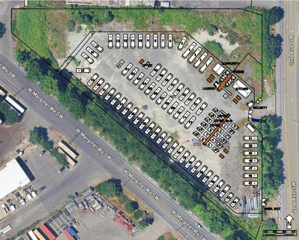 (‘Site plan’ from city permit filings)
By Tracy Record
West Seattle Blog editor
Two and a half weeks after we broke the news of a West Seattle site proposed for up to 72 RVs and 20 tiny houses [7201 2nd SW, map] – after which, our followup inquiries were largely met with “too soon to comment” – more details are finally emerging:
This week, Mayor Katie Wilson referred to the plan, saying toward the end of this post about homelessness-related issues, that “we are exploring every potential administrative and legal tool we have to accelerate the expansion of emergency housing and shelter, including by speeding permit approvals for projects like the upcoming RV Safe Parking program in West Seattle.” (“Speeding permit approvals” was foreshadowed by her non-site-specific executive order last month.)
Meantime, the King County Regional Homelessness Authority has revealed the cost and timeline for the project, which is on a state-owned site that WSDOT has used for storage and which also has been the site of illegal encampments, saying here that “The Low Income Housing Institute (LIHI) has been awarded the $3.3 million dollar contract to open the site at Washington State Department of Transportation’s (WSDOT) Glassyard site by summer 2026.” LIHI also operates West Seattle’s first and until now only tiny-house village, Camp Second Chance (9701 Myers Way S.), housing 79 people as of late January.
KCRHA also confirms what we reported the permit filings show: “The site will provide 72 parking spaces for vehicle residents, and 20 tiny homes, adding the capacity to serve 92 households.” Their update says “this project has been underway for some time now”; though the current filings did not appear in the city system until mid-January, there are filings from last June seeking review of the site for water/sewer access to serve what those documents outlined as slightly different numbers of RVs and tiny houses. (That review, never finalized, suggested building a 1,500-foot-long, foot-wide water pipe under West Marginal Way to serve the site.) Not all details about the current plan are finalized, though; a WSDOT spokesperson answered our initial inquiry by replying that WSDOT was “in continued negotiation” with LIHI about leasing the Glassyard property and “we do not have a definitive date for when the leases will be complete at this point.”
The city first publicly identified the site as a potential “transitional encampment” location more than a decade ago., Not long after that, a city-owned lot adjacent to the site was proposed for a relatively small RV lot, an idea relatively quickly scrapped. Some of the same questions that have recently surfaced about this are similar to what community advocates asked 10 years ago, such as whether West Seattle’s existing RV residents can get priority for spots at the new lot.
By Tracy Record
West Seattle Blog editor
More than 50 people filled a room at South Seattle College‘s Cascade Hall last night for a “community conversation” about parking along 16th Avenue SW in front of the campus.
The west side of the median-divided street is lined with single-family homes, and the street parking is relatively devoid of signage, so in addition to the vehicles of students and staff – who have to buy permits to park in campus lots – street parking is also used by RV/trailer/truck residents. The number fluctuates but we counted 10 on a visit earlier this week.
While that wasn’t mentioned in the meeting announcement, that was clearly what everyone was there to discuss – though not all agreed on what was at the heart of it. A panel of city reps included Tom Van Bronkhorst from the Unified Care Team; Mike Estey from SDOT; and Laura Fox from SPD Parking Enforcement (a listed panelist from the city’s “unsheltered services” program did not show up). SSC communications director Ty Swenson facilitated. Also there but not seated with the panel in front of the room were SSC president Dr. Monica Brown and District 1 City Councilmember Rob Saka‘s new policy adviser, Brendan Kolding.
The college wants to be “more than a neighbor in name … also a neighbor in deed,” said Dr. Brown in brief welcoming remarks. Swenson said SSC was trying to “approach this conversation” with a better understanding of “the needs of our unhoused population.” He said the conversation’s goals included the “opportunity to share your experiences” and to learn about the city’s approach to “supporting the unhoused population” and “parking enforcement” – tincluding the options that might be available for the latter.
Fox was the first city panelist to speak and said she empathized with the situation. Estey said, “We keep getting introduced as experts (but) it’s hard to be an expert on this issue.”
Swenson then provided “background from the college perspective,” saying Van Bronkhorst had contacted SSC last fall about possibly installing parking-restriction signage. “One of the things (he shared) was that these days the city most commonly puts up 2- and 4-hour signs” but that might not work for students, so SSC was looking for a wider range of possibilities. Swenson said they also were concerned that restrictions would just move RVs “further down the road.”
Van Bronkhorst spoke next, explaining the Unified Care Team – representatives from 10 city departments, “one part of the city’s overall response to homelessness … working on restoring access to public spaces” among other things. The UCT is “not a first-responding group” and “our mission is not to solve homelessness,” he clarified.
Fox said Parking Enforcement works with UCT, coming out during remediations and giving three-day warnings (those familiar orange notices). But they usually don’t move, and don’t get towed because people are living in them, she explained.
An attendee then spoke out about observing a recent situation where no-parking signs went up, people in RVs left, “and they came back.” Another attendee then voiced concern for trauma to the people who have been swept. Another attendee stood up and said she wants everyone to have someplace to live, and she’s paid taxes for that. But “we’ve dealt with so many things in the city in the past five years.” So has she, saying for example, she had to replace her fence, had to call police for someone peeping into her home. “Are there conseaquences when people are offered shelter (and don’t take it)?” She mentioned streets in other neighborhoods with barriers such as rocks. She said the city’s had five years to collect data but all she sees is the UCT “replacing propane canisters … The frustration is, I want everybody to be housed, you have the data, where is the plan? Do something …” She also said she was frustrated that Councilmember Saka himself was not in attendance. “He should be here,” she said, her voice continuing to intensify. Many in the room applauded when she was finished.
The next person to speak said, “There should be campers outside Rob Saka’s house … there should be campers outside all our houses” until things were equalized. Others in the room demanded to know whether the speaker owns property. The speaker replied, repeatedly, “I live here.”
Next person: Why aren’t tickets being given out, considering that the RVs block the bike lanes? Parking Enforcement supervisor Fox said there’s a rule for that but a ticket isn’t going to remove the RV. “There has to be someone calling in, we’re not just driving around looking,” She added that parking enforcement officers have safety concerns. She said that precinct officers often assist PEOs, and promised to “try to get out here more often.”
Another attendee said RV dwellers have been “aggressive” and also voiced concern that notification of the meeting hadn’t been distributed widely enough. They were followed by a person who said she had had more than half a dozen people in her family experiencing homelessness. “These people are being left out there to die … There is nothing compassionate (about that) …” She said at least one person had died in the area. “I would like the developers, the city, to fix th housing crisis” but believes that’s not going to happen any time soon. She thinks “a light, tight mobile camp” would be better, without room for big RVs – otherwise people are “sitting out there as bait for predators.”
The open-mic type of sequential commenting continued. Next was a resident identifying himself as a homeowner who said he’d put up a camera for six months to record what’s happening on the street. He said he had recorded some doing things he doesn’t like, but others are doing good things. “We ought to be forming relationships with them.” He says he has footage of people causing trouble for the RV residents – “we need to come up with a solution and not” treat them like outcasts. “They have nowhere to go. … We need to solve this problem at a housing level,” not at a level of making RV dwellers the enemy.
But almost every time someone suggested the need for that solution, someone else declared that wasn’t the point of the meeting, parking was. The next speaker declared she’s :empathetic’ but is fed up with problems such as a couple in one RV who frequently fight, with the disruption spilling out into the neighborhood. She added that she herself is an immigrant and naturalized citizen and “came here with nothing.” Then she suggested that there “are two different kinds of unhoused” … one type who “truly wants the help,” the other type who does not.
Shortly thereafter, Van Bronkhorst explained the outreach process and its limitations. “We don’t have a lot of great housing options .. we offer shelter, services, that are not great for a lot of people … we offer tiny house villages” but usually vacancies are rare because tiny houses are so popular. For RVs, they first try to clean up the area before a removal, “we’ll talk to them about their needs to keep their vehicles moving.” That’s when Van Bronkhorst spoke of the RV-safe-lot/tiny-house village plan we broke the news about last week (up to 72 RVs, 20 tiny houses), though he had few details.
SDOT’s Estey (who is the department’s curb-space manager) then took the mic to steer the focus back to the parking restriction issue. He said they’ve been installing 4-hour limits in places where people with RVs might want to park – “the (signs) tend to be self-enforcing.” (He is ‘curb space manager’ for the city. He also acknowledged that restrictions would “push the RVs to other places.” They tend to install such signage just on the commercial side (which in this case would be the east side, in front of SSC) because on the residential side there are more impacts. “There’s probably not a permit solution,” he said, for those wondering about RPZs, since there are specific conditions that need to be met. They could do a study, he said, to verify whether an RPZ would be justified. And he acknowledged that, yes, overnight parking is illegal, but SPD isn’t staffed overnight to enforce that.
Could they put jersey barriers every 30 feet or so? he was asked. “Our preference is not to have to default to something like that,” or putting eco-blocks in the right of way, Estey said, “but we also understand why they end up there because people feel a sense of desperation.” Van Bronkhorst said the last mayoral administration did not enforce removal of ecoblocks but he doesn’t know what “the new administration” thinks. He mentioned some neighborhoods putting out metal planters. “That’s not legal,” several attendees said, while others quickly pointed out no one was enforcing that. (A little while later, someone else mentioned that the arrival of ecoblocks after a sweep on Highland Park Way seemed to have preceded RVs’ move to 16th. They said they’d reported street obstructions via Find It Fix It but “they’re still there.”)
Another person wondered whether there should be special consideration here since SSC is a school. Estey observed that “it’s unique that you have a college with single-family (homes) across the street.” He said parking enforcement would likely come out more often if there were signs. “We need parking restrictions on both sides of the street,” an attendee said. “And at Sanislo Elementary,” added another, referring to Puget Ridge’s other school.
Van Bronkhorst mentioned another signage tactic, putting up signs asking for voluntary compliance “be a good neighbor, kids live here too.”
Then an attendee who said they’ve lived in the area for 32 years read a statement about her “personal experience.” She said crime problems had arrived with the RVs. “I don’t think sweeping is the answer, but we’re not here to solve the housing crisis.” She said her car had been stolen, and several others spoke up to say theirs had too. She said she is not comfortable walking in the neighborhood any more and declared “this isn’t about punishing pople who live in vehicles, this is about public safety.”
The next speaker countered by declaring that everyone is a neighbor, including renters, and RV dwellers. She said parking restrictions would likely push RV dwellers into places “in front of people’s homes” while currently they tend not to be “in front of people’s entryways.”
“What about the north lot, could they park there during the day?” A college rep explained that tudents pay $50/quarter for permits and the north lot is open to them at any time. “Why not open that up and let the students park there for free?” Soeone asked how many students pay for parking passes; 700 was the guess.

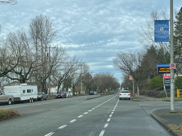
A few murmurs around the room started coalescing around signage with 11 pm to 5 am restrictions like on Harbor Avenue (as shown above in a WSB photo from September 2023). An attendee who said they had worked on signage for a variety of concerns countered, “Signs in this case do not solve the fundamental (problem) we’re trying to deal with … I don’t think signs are going to solve the problem.” They said someone does park in front of their residence and “I do not want them swept.” Signs are being deployed to push people out of the area, they said. They support the north lot parking idea. Others in the room said they felt signage would help the situation. Then again, the point and counterpoint, some saying “we’re not here to solve the housing crisis” and others saying, “You should be.”
Fox from Parking Enforcement said most vehicle dwellers don’t have registration. She thinks RV “safe lots” are the solution. “That way all the services come to them.” Someone wanted to know if RV dwellers will be “compelled” to go to the safe lot once open. That attendee claimed people in a few of the RVs are “running criminal enterprises” and won’t want to. “When they say no … what are you going to do?”
Van Bronkhorst replied, “Well, people have a choice” and also mentioned potential obstacles that kept some people in RVs from being able to access such lots in the past, such as having to prove their ownership of the vehicle and being on a pathway toward housing and eventually giving up their RV. He isn’t sure if that’ll be the policy. But no, he reiterated they’re not going to force people into the lots. (The request came later, though, that West Seattle RV dwellers get priority at the West Seattle lot.)
So, the discussion turned back to, what signage might be tried in the area?
“No overnight parking … both sides of the street.” voices said from around the room.
Then again came a reminder that the problem goes beyond parking, advocating for state legislation supported by the Seattle/King County Coalition on Homelessness.
Another man stood up and said, “We give way too much services to these people, 60 percent don’t even come from this area.”
That led to further points and counterpoints – including whether the topic was parking or homelessness, another attendee suggesting that government “has a spending problem,” another suggesting enforcement is needed rather than more signs, yet another wondering about a “no camping” ordinance, and someone else turning the attention to the Highland Park downhill-lane removal and wondering how many were aware SDOT is planning on that. “I just wanted to say that out loud,” he said. “SDOT ran surveys, most people are against (the project), and they’re going to do it anyway.” Estey said he’d “take that sentiment back” to SDOT HQ.
That in turn segued into questions about how feedback from this meeting will be conveyed to decisionmakers. Any other routes for providing community input? they wondered. Another attendee suggested, “The folks (who park) are there because they (consider that) their best option – we can either make this option worse or make other options better … I think the compassionate choice is to make other options better.” A “no camping” ordinance would be irrelevant, he said, because “they’re not camping … this is their house … you can’t stop camping if that’s your house.”
Then Estey took on the followup question. He said people can contact the city. Van Bronkhorst asked for contact info from 16th SW residents: “I think we’ve heard enough options we could make some suggestions … to remediate the situation as it currently is … it seems neighbors have been asking for a ‘now’ answer … we can come up with some options, send them to (Swenson at SSC), and get some feedback.” He declined to hone in on just one idea immediately, and would not commit to a timeline for a proposal and action, even acknowledging, with uneasy laughter, that the response was basically a “non-answer.”
The addresses provided were two contacts at SSC:
brian.jellum@seattlecolleges.edu (security)
ty.swenson@seattlecolleges.edu (communications)
From the city:
mike.estey@seattle.gov
tom.vanbronkhorst@seattle.gov
(From ‘site plan’ in proposed lot’s permit filing)
Eight days after we broke the news of a combination RV “safe lot” and tiny-home village planned for southeast West Seattle, a city official brought it up at a community meeting tonight for the first time. The meeting was the South Seattle College (WSB sponsor) discussion of possible parking restrictions on 16th SW, where about 10 RVs and trailers are currently among the other parked vehicles; we’ll have a full report on the meeting, and what’s next, Thursday. But first – the city official who mentioned the possible shelter site is Tom Van Bronkhorst, a longtime community liaison for the city’s homelessness response. Some attendees suggested a “safe lot” might be ideal for RV dwellers; Van Bronkhorst said he’d just recently heard about the one on the drawing board for 2nd SW, saying there’s some “lease activity.” Timeline? He said he didn’t have specifics but speculated at least “several months.” That’s more than we’ve heard from those with whom we’ve followed up; WSDOT, the site’s owner, promised a response that we’re still awaiting, while Mayor Katie Wilson‘s spokesperson told us it was still too early-stage for them to have anything to say, and the organization listed as site operator, LIHI, has not replied at all.
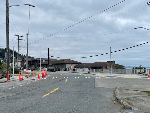
We’ve gotten a lot of questions about this incident around 7 am, with erroneous information circulating on social media, so for those who’ve asked, we wanted to let you know that the pedestrian hit by a driver at 35th/Thistle is recovering. We’ve also heard from one of the first people on the scene, Jesse:
This morning, while I was waiting at a bus stop on 35th just north of Thistle for the northbound 21 a pedestrian was struck by a car while crossing 35th at approx. 7 a.m. This happened at the northwest corner of 35th ave SW and SW Thistle st.. The driver stopped, I called 911, several of us waiting at the bus stop attended to the pedestrian, who was awake and alert. Paramedics and SPD showed up a few minutes later to help the pedestrian and question witnesses and the driver. … I wanted to let you know in case it’s worth posting on WSB and mostly to build awareness for pedestrians and cars to be careful during the morning commute. It’s still dark at 7 am and unfortunately it’s too easy for drivers to not see pedestrians, even when they’re in a crosswalk.
A few of the people we heard from were worried the pedestrian had died because they saw the victim under “a tarp.” That’s an emergency blanket used at incident scenes. SFD tells us the pedestrian is a woman in her early 40s, in stable condition when transported to the hospital by AMR ambulance.
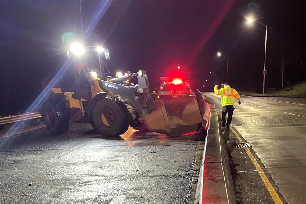
 (SDOT photos, Sunday night)
That’s what SDOT crews had to fix when they closed the Fauntleroy end of the eastbound West Seattle Bridge for more than two hours Sunday night. We reported on it in real time and promised to follow up to find out why the barrier fix – usually a relatively quick job – took so long, and SDOT spokesperson Ethan Bergerson sent this explanation with photos, today:
SDOT was notified by SPD at approximately 6:45 p.m. on Sunday, February 1 that a vehicle had hit the center concrete barrier on the Fauntleroy Way SW approach to the West Seattle Bridge. This collision moved the center concrete divider out of place.
An SDOT Response Team (SRT) vehicle attempted to push the barriers back into place, but two of the four concrete barrier sections became stuck and were unmovable. It was necessary to bring in heavy equipment from the SDOT maintenance yard, which finished pushing the barriers back into place at approximately 10:30 pm.
All eastbound lanes of Fauntleroy Way SW were closed for most of this time, with a short period when one lane was briefly reopened and then closed again.
The only crash on the SFD log for that time frame was 7 pm, listed as Fauntleroy/Avalon; one of the challenges for keeping stats on that end of the bridge – yes, it was by “the curve” – seems to be the various location descriptions.
Last night, we reported on Seattle Public Schools updating policies regarding immigration enforcement. Today, we’re hearing the City of Seattle is doing – here’s what the mayor’s office sent:
Mayor Katie B. Wilson today announced an initial set of actions to protect city residents in the face of increased federal immigration enforcement activity. While the City currently has no information indicating a surge of ICE and CBP activity, there has been increased activity over the last year, and appropriate preparation is critical given the unpredictable, chaotic, and violent behavior of the federal government. Successfully protecting our community from federal agents will require bold leadership by elected officials, close coordination between different government bodies, and extensive community organizing.
“Whoever you are, and wherever you come from: if Seattle is your home, then this is your city,” said Mayor Katie B. Wilson. “And it’s our responsibility as city leaders to move quickly and get organized so we can keep people safe. That is why I am taking immediate steps today to bar federal agents from using city property for federal civil immigration enforcement activity, update SPD protocols, and support trusted community partners to aid the community response, which is our most powerful tool.”
“I understand the concern and anxiety in the community, and I want to make sure everyone knows that the police are here to keep you safe, regardless of your immigration status,” said Seattle Police Chief Shon Barnes. “The City of Seattle is a welcoming city, and my officers will continue to abide by all laws and regulations that prohibit our participation in immigration enforcement. While we have no authority over federal agents or federal policies, we will document incidents if and when notified. The Seattle Police Department’s primary responsibility is the life safety of ALL people.”
Seattle’s response starts with the necessary, basic, and important work of city government. The City will promptly provide all employees updated training on the appropriate way to report and respond to enforcement activity in the current environment. All departments are directed to conduct a privacy review aimed at limiting potential data exposure, including by reviewing data sharing agreements in vendor contracts. Clear signage will be posted designating private spaces on city properties. And we will ensure coordination with other local, regional, and state bodies to ensure the most effective possible response in a potential emergency situation.
In addition, the mayor will take several concrete steps to clarify the role of local law enforcement, provide direct support to immigrant rights organizations, aid community organizing efforts, and forbid ICE from making use of city-owned property. Specifically, the mayor will:
*Require the Seattle Police Department to investigate, verify, and document any reports of immigration enforcement activity. If dispatched to a location where apparent immigration enforcement activity is underway, officers will document the activity with in-car and body-worn video, validate the status of apparent federal law enforcement agents through official identification, and secure scenes of potentially unlawful acts to gather evidence for transmittal to prosecutors.
*Mandate close cooperation between city departments and community organizations to ensure everyone has the latest and most accurate information about federal enforcement activities. In particular, this information will be shared with a hotline operated by our trusted community-led organizational partner where concerned community members can be connected to support, resources, and information in response to immigration enforcement activity.
*Issue an executive order immediately prohibiting civil federal immigration authorities from using property that is both City-owned and City controlled for civil immigration enforcement activities, including City parks, parking lots, plazas, vacant lots, storage facilities, garages, and the Seattle Center. The mayor urges the Seattle School District, Seattle Municipal Court, and other local government bodies to take similar action.
*Establish the Stand Together Seattle Initiative, which invites private property owners to post notice clarifying that their property may not be accessed by federal agents without a warrant.
*Quickly invest $4 million in city funds to organizations engaged in immigrant legal defense, community support, and the long-term needs of immigrant communities. This money was appropriated by City Council late last year, and we are working to quickly invest the funds. …
The news release concludes with quotes from the mayor, City Attorney Erika Evans, and Public Safety Committee chair Councilmember Bob Kettle; you can read them all here. Meantime, other city councilmembers sent their own news releases saying they support what the mayor is doing, including District 1 Councilmember Rob Saka, whose statement is here.
Eight days after rumors of ICE presence led to four Seattle Public Schools campuses (none in West Seattle) going into shelter-in-place mode, the district has a new webpage and policies to address those types of concerns and others surrounding immigration-enforcement operations. They were briefly presented and discussed in the first 50 minutes of tonight’s special meeting of the Seattle School Board (the second part of the meeting, still under way, is a budget update).
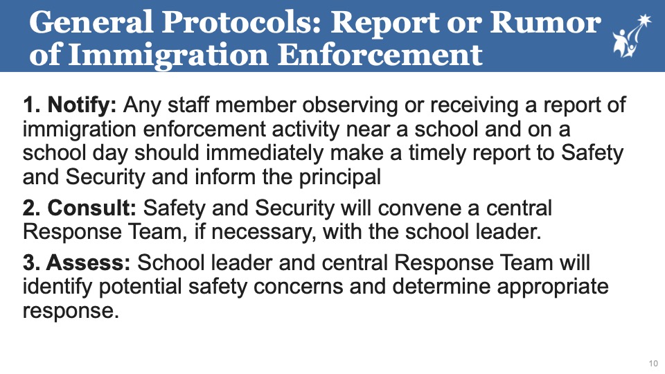
First – here’s the slide deck from the presentation/discussion. It includes word of this new page on the district website devoted to the topic. Here are the toplines on dealing with “reports or rumors” of ICE activity near schools:
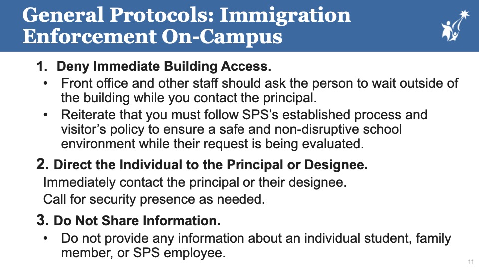
What if agents actually show up on campus? That was addressed too, with superintendent Fred Podesta noting it’s similar to how they deal with any type of law-enforcement officer turning up:
And finally, a resource page:

District officials say the updated policies and clarifications will be discussed with building leaders this Friday; how they’re rolled out to the rest of school staffs, they said, is up to building leadership. They said the point of the policies is to be simple and easily committed to memory, so no one will have to “run for a three-ring binder” to figure out what action to take.
One year ago, SDOT announced “next steps” for the Alki Point Healthy Street, including an upgraded crossing at its south end, at 63rd SW and Beach Drive SW. Crossing work has been done, as shown in our recent photo above, but the poles have been in place, beaconless, for a while. So we asked SDOT for an update. The reply: “The RRFB equipment for the upgraded crossing at the south end of the Alki Point Healthy Street has been ordered and we are waiting for them to be delivered.” No timeline estimate so far.
Local and state leaders all had Minnesota on their mind today. Three notes:
First:
 (Governor’s Office photo)
“It’s outrageous in the extreme and it has to stop.”
That’s what Gov. Bob Ferguson said today about what’s happening in Minnesota, appearing at a media briefing with state Attorney General Nick Brown (a West Seattle resident). He wasn’t only speaking about the killings by federal agents of Renée Good and Alex Pretti, but also about their enforcement tactics, “plucking people off the street” and going into homes without judicial warrants.Ferguson and Brown detailed some of the steps they’re taking in case a federal escalation happens here, though they said they’re not revealing all the steps they’re taking in preparation, so as to not reveal their “playbook” to the feds. “We will not allow this administration to turn our nation into an authoritarian regime,” vowed Gov. Ferguson. Attorney General Brown said what’s happening has nothing to do with the president’s vow to “go after the worst of the worst” and described the administration as a “cabal of cruelty.” He also said it’s important to not just “hunker down and try to survive the next few years,” but to focus on preparedness and action. “Everyone in our state” has a role in that, they said. You can watch the entire news conference here.
Second:
Seattle City Councilmembers voiced their outrage at their weekly “briefing meeting,” where each member provides updates and observations. Our area’s Councilmember Rob Saka, noting that he’s a Minnesota native, decried the killing of Alex Pretti as “another horrific execution-style … murder of a resident.” Saka said it’s “appalling and outrageous” that federal agents are “running amok … killing people for no reason.” (His remarks are 47 minutes into the meeting video above.) Councilmembers reiterated the call to ensure the city is prepared, including the Public Safety Committee‘s chair Councilmember Bob Kettle, whose committee meets tomorrow morning.
Third:
We’ve learned that Fauntleroy Church‘s pastor Rev. Leah Atkinson Bilinski was part of a Northwest clergy delegation that went to Minnesota as a show of support. She is back and slated to speak during a protest rally at the Federal Building in downtown Seattle tonight, around 20 minutes into the 5 pm rally. We hope to speak to her about her Minnesota trip soon.
 (WSB photo from this afternoon – mostly dry now)
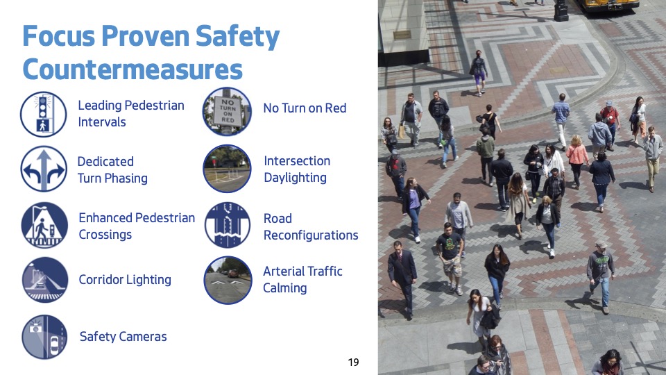
This long spell of dry weather has resurfaced a longrunning problem – water running down the Admiral Way hill toward the bridge. One week ago, Laura emailed us to ask about it:
I am puzzled by how and why the city is allowing so much water to flow across lower Admiral Way. I can see that there were blog posts about it several years ago, but over the last couple of weeks it has become much worse. If our temperatures drop, it will be a massive ice rink! Have you heard anything from the city about this?
As a result of that inquiry, we had asked SDOT about it even before it led to exactly that problem – an “ice rink” – on Wednesday morning. SDOT first redirected us to Seattle Public Utilities, whose spokesperson Travis Gershaneck initially responded:
This location appears to be a known area of surfacing groundwater. Surfacing groundwater is a natural condition in Seattle, and the City works to manage and mitigate impacts of these sites where possible. If icy or otherwise unsafe road conditions occur, the Seattle Department of Transportation is the lead agency and can be contacted at (206) 684-ROAD. For urgent drainage or flooding concerns, Seattle Public Utilities’ 24/7 Operations Response Center can be reached at (206) 386-1800. These operational lines are the best way to reach our hard-working crews and allow for the most timely response.
By then, Wednesday morning’s freezing fog had struck, and we asked SDOT how they’d responded. Spokesperson Mariam Ali replied:
Our crews are aware of the reported black ice on Admiral Way. A truck was dispatched to the area earlier today, and we will continue to monitor the location. A salt truck will be checking the corridor (Wednesday night) and treating as needed to address any icy conditions.
Then today, we got an update from SPU spokesperson Gershaneck:
Thanks again for reaching out and bringing the issue to our attention. I wanted to follow up with some actions we’ve taken in the area in the past 24 hours.
We contacted our Operations Response Center before we discovered it was a known surfacing groundwater site. An SPU crew was dispatched and able to clean nearby catch basins, which may help reduce additional water sources adding to the surfacing ground water issue. They also requested an overnight street sweeping to remove debris along SW Olga St to SW Spokane St. Although the surfacing groundwater is expected to continue, these actions may help mitigate some impacts in the near term.
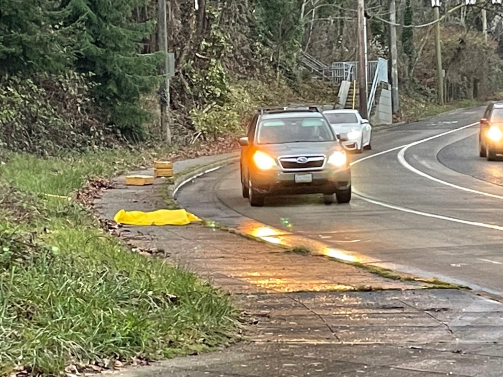
As previewed here, the newly expanded-in-scope committee chaired by District 1 City Councilmember Rob Saka got a general SDOT update during its first meeting of the year. The department’s new director Angela Brady was there for the meeeting of the Transportation, Waterfront, and Seattle Center Committee, but mostly to introduce chief transportation-safety officer Venu Nemani, who led most of the briefing. As shown in the slide deck presented during the meeting, 25 people were killed on Seattle streets last year, mostly people on foot:
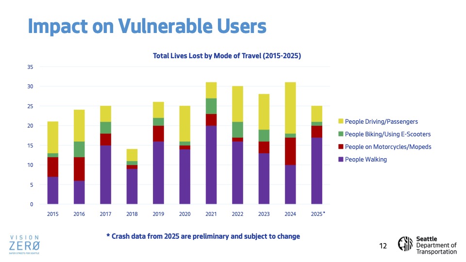
In an attempt to reduce that, SDOT has continued expanding a variety of tactics:
It’s added “no right turn on red” signage in more than 800 places, with fewer than 200 left to add, and is planning more “enhanced crossings” with marked crosswalks:
Speed cameras are still in the study mode, so don’t expect to see those soon.
Also of note, the potential implementation of “shared streets,” which sound somewhat like Healthy Streets:
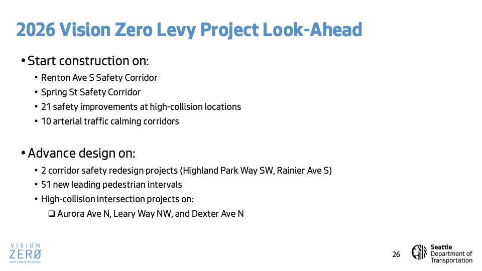
The presentation mentioned only one West Seattle-specific project, the plan to convert the outside downhill lane on Highland Park Way to a bike/foot path, described as in design this year:
(The project website hasn’t been updated since spring.) No votes at this meeting; it was just a briefing, but a window into where SDOT is focused right now.
SDOT sent that photo as part of a reply to our question about the status of the additions it promised at “the curve” toward the southwest end of the westbound West Seattle Bridge, a location that’s seen more than a few crashes. The department says its crews have finished installing what it told us about two weeks ago – “curve warning signs, and raised pavement markers to enhance visibility for approaching drivers.” SDOT says they’re still evaluating additional action, including “reflective markings on the existing guardrail” and “either grinding the top layer of pavement or installing a high-friction surface treatment.” We’ll continue following up.
12:25 PM: Mayor Katie Wilson has announced her first two executive orders. One is regarding homelessness. Here’s how the city announcement summarizes it:
Mayor Wilson is ordering immediate action to bring people inside by expediting the expansion of shelter and affordable housing.
Her executive order to accelerate the expansion of emergency shelter and affordable housing will:
-Rapidly expand and expedite the provision of new shelter and affordable housing by immediately launching an interdepartmental team to identify options for financial incentives, permitting changes, and other policy changes.
-Identify and prioritize city-owned public land and other public lands which could be used to temporarily or permanently site new emergency shelter and housing.
-Coordinate with regional partners to identify shelter programs that have capacity to add units to existing programs.
-Identify best practices working with organizations with expertise in behavioral health to support substance use disorder treatment and mental health counseling for housing and shelter programs.
You can see the actual order text here. We’re asking some followup questions, including the timeline. The other executive order involves a bus lane on Denny Way downtown; read that order here.
ADDED 3:28 PM: We received answers to our followup questions via mayoral spokesperson Sage Wilson.
-We asked about a timeline – “rapid” could mean many things. His reply: “The literal reality of ‘rapidly’ is one of the early outcomes of the EO – need to hear from the departments what is possible. The mayor is determined to move quickly, however, and spoke today about FIFA this spring as a time to take stock. (Her full remarks are available on Seattle Channel.)”
-We also asked if encampment resolutions (sweeps) were being suspended until more shelter is available. The reply: “Resolutions of encampments are not suspended and the Unified Care Team certainly still exists and is still at work. For example, I believe an RV site near the stadiums was just cleared recently. The mayor is assessing how we can do better than the current procedures, and her visit in Ballard yesterday was part of that to really see for herself. But resolutions are continuing to proceed – city reporting shows 101 resolutions of encampments & RV sites since 1/4. And as the mayor said in her statement yesterday, clearing encampments and managing public space will continue to be part of the city’s approach.”
One question Wilson is checking on further – and we’ll add the answer when it arrives – is whether private shelters like the one in West Seattle have a role in the planned pursuit of more space.
ADDED 3:41 PM: The answer to that: “Yes, expanding privately operated shelters is one strategy that would help meet the goals in the Executive Order on expanding shelter.”
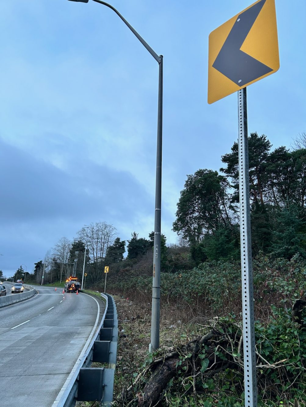
Thanks to the texter who sent that dashcam video along with an alert about the lane closure it shows, at “the curve” that’s been the location of more than a few crashes, toward the southwest end of the westbound West Seattle Bridge. We’re not finding an official traffic alert about it, but given the presence of at least one Seattle City Light truck, it could be work related to the crash the other night that brought down a pole at the pullout (we’ll check with SCL in the morning). In the meantime, if you’ll be headed that way, or know someone who will, caution is advised.
8:19 PM: Thanks for the tips. While we were away from the desk for a while, yet another collision was reported in the curve/pullout area toward the southwest end of the westbound West Seattle Bridge. The SFD 911 log shows initial dispatch just after 6 pm; there was another dispatch just before 7 but archived radio indicates that was NOT a new crash – apparently someone called in the same one a second time. Our video shows the spun-out car and downed pole/sign around the time of the second response – we assigned a back-seat passenger to try to get a visual as we past eastbound; that didn’t work so we turned around and went westbound, and what you see is what we got – the car is briefly visible around :13 in. We’re checking with SFD re: injuries. If you missed it, here’s our latest story on what SDOT says it will do regarding the crash risk in that area.
10:19 PM: SFD says no injuries were reported.
 (Reader photo sent by CJ, December 14)
By Tracy Record
West Seattle Blog editor
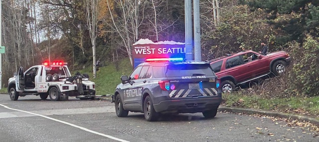
Is it the drivers’ fault or the pavement’s fault? The discussion reignites almost every time we report a crash toward the southwest end of the westbound West Seattle Bridge, in the general area of the pullout near the two remaining “Walking on Logs” sculptures and the “Welcome to West Seattle” sign. The “drivers’ fault” faction says people are just driving too fast. The “pavement’s fault” faction blames an inconsistency in the road surface right in that spot.
 (Reader photo sent by Mike, October 26)
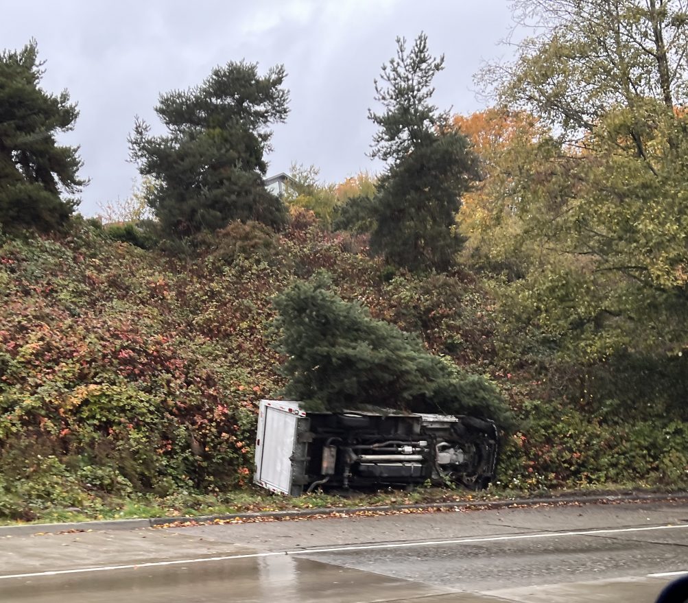
We don’t have hard-and-fast data on crashes at this location – the SDOT collision map is neither comprehensive nor (location-wise) precise, and our archives are not necessarily comprehensive either, nor is publicly visible data: The SFD 911 log will show a collision only if there was a dispatch for injuries, and the SPD police-data map if the crash was reported by a 911 caller. Plus, there’s no functioning traffic camera in that spot, so for visuals, we’re reliant on reader photos. But our archives alone show more than a dozen mentions of crashes in that spot just this year.
 (Reader photo, October 24)
Back in February, we sought and reported on SDOT’s response to our inquiry about whether any action was planned regarding this area. A department spokesperson said at that time that they planned “to add safety enhancements to encourage drivers to approach the curve at a safer speed” and then might evaluate pavement work if that didn’t help. The timeline given was “this year.”
 (Reader photo, OMarch 24)
So now we’re at the end of “this year.” After more crashes in mid-December, we asked SDOT for an update. Here’s how they responded this time:
Based on recent crash activity and additional review, we will be installing two near-term safety enhancements to improve driver awareness of the curve:
-curve warning signs, and
-raised pavement markers to enhance visibility for approaching drivers.The work orders have been issued.
This represents a slight change from what was discussed earlier this year. While reflective markings on the existing guardrail were previously mentioned as a potential third treatment, that option is still under internal evaluation.
As we shared in February, our pavement engineers and Vision Zero team have also been evaluating longer-term solutions to improve traction in this area, including either grinding the top layer of pavement or installing a high-friction surface treatment. Those options remain under consideration and would need to be scheduled further out, taking into account resources, weather, crew availability, and traffic impacts.
We’ll continue to monitor conditions at this location and assess whether additional measures are recommended.
Some pavement work was done in that area during the 2020-2022 West Seattle Bridge closure, as we reported, and showed, in this story about a visit to the work zone toward the end of bridge-repair work.
 Seattle Public Utilities’ policies/schedule regarding Christmas-tree disposal:
Customers can compost trees and holiday greens for free from December 26 – January 31! Remove all decorations, cut into sections 4-foot or less, and place trees or bundled greens next to your Food & Yard Waste cart on your regular collection day. Apartment residents may place up to two trees next to each Food & Yard waste cart at no charge. You can also drop off up to 3 trees less than 8 feet in length at a Transfer Station.
And also, a reminder that the “regular collection day” is disrupted for some again this week:
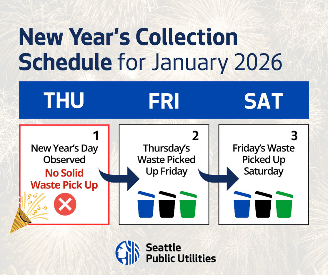
No change for Monday, Tuesday, Wednesday pickup customers, but no collection on Thursday, so Thursday customers will get pickup on Friday, Friday customers will get pickup on Saturday. The transfer stations are closed on New Year’s Day too. So bottom line, you have until the end of January for free tree disposal – but if your tree is drying out, better to avoid fire risk by not letting it stay until it’s unsafe.
We heard a bit of the radio exchanges about this around 10 this morning but not enough description to write about – until this photo came in just now, literally completing the picture. (Thanks to CJ for sending it.) Another crash in the area where some think the pavement is the problem, and others blame speed. The driver of this 4Runner wound up in the grass by the “Welcome to West Seattle” sign; no other vehicle was reported involved, and the initial SFD dispatch to check out the driver was quickly downsized.
 (Access during construction)
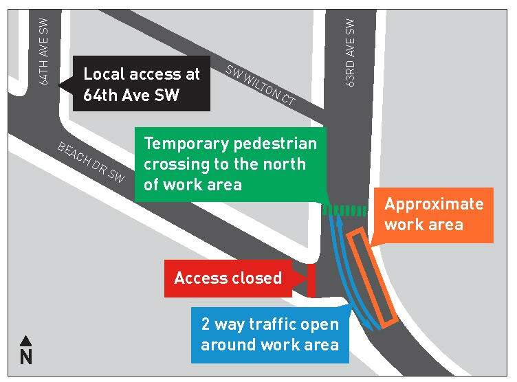
Last month, when SDOT announced it would proceed with additions promised for its Alki Point Healthy Street (Beach Drive and Alki Avenue west of 63rd), it didn’t have a date beyond “as soon as later this year.” This afternoon, SDOT sent an update saying work will start “as soon as the weekend of December 20,” for the 63rd/Beach Drive crossing features. Here’s the plan for the 63rd/Beach work:
As soon as the weekend of December 20th, we’ll begin installing intersection upgrades at 63rd Ave SW and SW Beach Dr. Crews will install new accessible curb ramps and a new flashing pedestrian crossing sign. Work is expected to occur over a three-week period, with some pauses between phases like demolition and pouring new concrete. We plan to work on one side of 63rd Ave SW at a time to minimize traffic impacts.
During the work, you can expect:
-Primary work hours from 9 AM – 3 PM, Monday-Sunday. Crews may set up or take down equipment outside of these work hours. Crews will not work on December 25 or January 1.
-Temporary sidewalk, crosswalk, and lane closures.
-Access to Beach Dr SW at 63rd Ave SW will be closed while crews are working. Local access will remain open via 64th Ave SW. Access will re-open outside of working hours.
-Traffic shifts around the work area on 63rd Ave SW. Traffic will remain open in both directions with the assistance of flaggers.
-Relocated pedestrian crossing across 63rd Ave SW north of the work area.
-Signed detours for pedestrians and protected pedestrian walkways around the work areas.
Other planned additions won’t be installed until next year, according to today’s SDOT update, because they need drier weather.
Of all the policy areas over which Mayor-elect Katie Wilson will preside, much speculation has centered on public safety – what will she do to help make Seattle a safer city? Today she’s announced her “vision for public safety,” including her decision to keep the current public-safety chiefs (Police, Fire, CARE chiefs and Office of Emergency Management director). Here’s her full announcement:
Seattle’s next chapter begins with a commitment to a shared vision of community safety: that everyone in Seattle, of every background and every income, deserves to be safe in their homes, streets, parks, and places of business in every neighborhood across our city. We envision welcoming public spaces, thriving local businesses, and lively communities where every person is safe, supported and valued. Achieving this vision requires a comprehensive strategy that builds trust, strengthens accountability, and modernizes our public safety system so it works for everyone who lives, works, and travels in our city.
I understand public safety as a shared responsibility, requiring police, fire, emergency management, alternative responders, service providers, community leaders, businesses, and residents to work together to get results. And it is time to build a coordinated, modern system which reflects that shared responsibility and helps us address our most difficult challenges, including persistent neighborhood-based safety issues, gun violence, behavioral health, and substance abuse.
That’s why I am retaining Seattle Police Department (SPD) Chief Shon Barnes, Seattle Fire Department (SFD) Chief Harold Scoggins, Office of Emergency Management (OEM) Director Curry Mayer, and CARE Chief Dr. Amy Barden. They are each committing to lead their departments in accordance with my vision of community safety. With active partnership and direction from the Mayor’s office, I believe these leaders can work together and form a unified team committed to strengthening coordination, reform, accountability, and results.
My administration will work with Chief Barnes to make SPD a place where professionalism, integrity, compassion, and community partnership are at the center of every action. We will strive for a workplace culture where employees are valued and empowered. Promotions will be rooted in performance, integrity, and good judgment, and every SPD employee will be encouraged to share concerns, experiences, and good-faith feedback with leadership. I am committed to retaining and recruiting officers who represent the diversity and values of Seattle, and to building trust between SPD and communities across the city.
SPD cannot — and should not — respond to every challenge alone. My administration will work with Chief Barden to fulfill the mission of the CARE department to respond to calls that do not pose a threat of violence or involve a medical emergency. CARE now houses our diversion programs, public safety shelter resources, and street safety teams, moving toward a more fully integrated continuum of response to public order issues stemming from unmet needs. And central to our modern, diversified safety model, seamless coordination between SPD, CARE, and other non-police services will ensure the right responder is dispatched for behavioral health crises, welfare checks, and nonviolent situations. Fulfilling CARE’s intended role is essential to improve outcomes for vulnerable residents and neighborhoods alike and to support sworn officers to focus on the critical work for which they are the right responders.
SFD under Chief Scoggins will continue its national leadership in life safety and emergency medical response and deliver high-quality fire, EMS, and rescue services across all neighborhoods.
And through Director Mayer’s leadership at OEM, we will build our city’s resilience to disasters, including severe weather, and emerging threats by working hand-in-hand with communities to ensure preparedness efforts reflect their needs and strengths.
Most fundamentally, our vision of public safety will be rooted in community partnership. We will build long-term relationships in neighborhoods and work intentionally with service providers, outreach teams, diversion case managers, business improvement areas, small businesses, and community organizations and adopt a problem-solving approach that addresses root causes instead of relying solely on enforcement.
Seattle is ready for a new chapter — one where public safety is effective, equitable, accountable, and rooted in partnership with our communities. And with this leadership team, and with your support, we will deliver a safer, stronger, and more resilient Seattle.
While the work of these four departments is essential to keeping Seattle safe, a comprehensive vision of public safety involves the work of many more City departments and stakeholders. Public safety also means protecting our immigrant communities, ensuring the safety of LGBTQ+ community members, protecting privacy and addressing concerns around surveillance technology, and preventing traffic violence and ensuring that our streets and public spaces are safe for all users. It also means working to ensure that every resident has what they need to live a dignified life, so that fewer people commit crimes of poverty and desperation. My administration will take this holistic approach to public safety seriously and we will be announcing further decisions and actions in the weeks and months ahead to further this vision.
(WSB photo from Election Night)
Three days after a death at the encampment near Rotary Viewpoint Park (35th/Alaska) and West Seattle Stadium, city crews swept the area – “resolution” is the official city term. But it wasn’t a reaction to the death; the city had told a reader – in November 7 communication on which we were CC’d – that the site was “elevated to be resolved soon, pending availability of the necessary shelter resources.” Then another reader told us late Wednesday that they had seen crews there earlier in the day. So we followed up with the city’s Unified Care Team spokesperson Kate Jacobs, who confirmed:
Rotary Viewpoint Park/West Seattle Stadium vicinity: The Unified Care Team completed resolutions at two unauthorized encampments in this area on December 3 after official notice was posted on November 29. UCT outreach counselors offered shelter and supportive services to all 30 people residing across the two locations. Four offers were accepted.
 (WSB photo, 16th/Barton, Tuesday)
We also asked about the results of the city operation reported here Tuesday at 16th/Barton, long an RV encampment zone. Jacobs replied:
SW Barton: UCT outreach counselors offered shelter and supportive services to both individuals residing at this location. Neither offer was accepted.
Jacobs said that’s not the end of their work at those sites:
Outreach counselors will continue engaging with people who declined resources to learn more about each person’s needs and keep building trust. It often takes numerous interactions before someone is willing to accept services, shelter, or complete an assessment for permanent supportive housing.
The reader who tipped us about the stadium/Rotary Viewpoint Park sweep wondered if the people there had had much notice, so we asked Jacobs about the current policy:
UCT gives people as much notice as possible for a resolution. The amount of notice is determined by local regulations, the unique circumstances of each site, and available resources.
Sites that require 72-hour notice under the Multi-Department Administrative Rule (MDAR) receive at least that much notice and sometimes significantly more.
Immediate Hazards/Obstructions are situations in which UCT must act quickly due to health or safety risks, or because an encampment significantly obstructs access to public spaces. In these cases, UCT notifies individuals of the resolution when they arrive on site, typically providing 30 minutes of notice before work begins. Once immediate safety risks and hazards are addressed, UCT works to provide reasonable time for people to pack personal belongings and identify items they’d like UCT to store versus debris that can be thrown away.
Sites that do not qualify for a 72-hour notice under MDAR and are not an immediate hazard or obstruction typically receive between 24 and 72 hours of notice.
Last June, after months of controversy over City Councilmember Rob Saka‘s espousal of removing a centerline curb on Delridge Way, he and Mayor Bruce Harrell announced the curb would stay and three other projects would be done instead. The biggest of those projects is about to start:

SDOT says work could start as soon as this Friday (December 5) on the 22nd/Delridge turnaround. From the flyer it’s sent to nearby residents:
New Turnaround at Delridge Way SW and 22nd Ave SW
As soon as Friday, December 5, the Seattle Department of Transportation (SDOT) will start construction at Delridge Way SW and 22nd Ave SW in the Delridge neighborhood at the request of City Councilmember Rob Saka pursuant to a budget investment passed by the Full Council. We will reconfigure the triangle at Delridge Way SW and 22nd Ave SW by building a 24-foot wide turnaround on the north side of the triangle connecting the two streets (see map). This will improve circulation for people driving in this part of the Delridge neighborhood. Please note this project will remove the existing informal parking in this triangle and add landscaping within the triangle area south of the street segment.
The other two projects involve signage; together, all three cost $500,000, according to SDOT, a quarter of what the original plan was budgeted for.
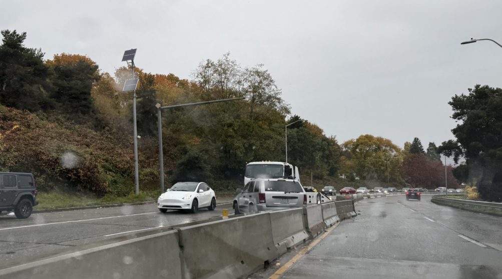
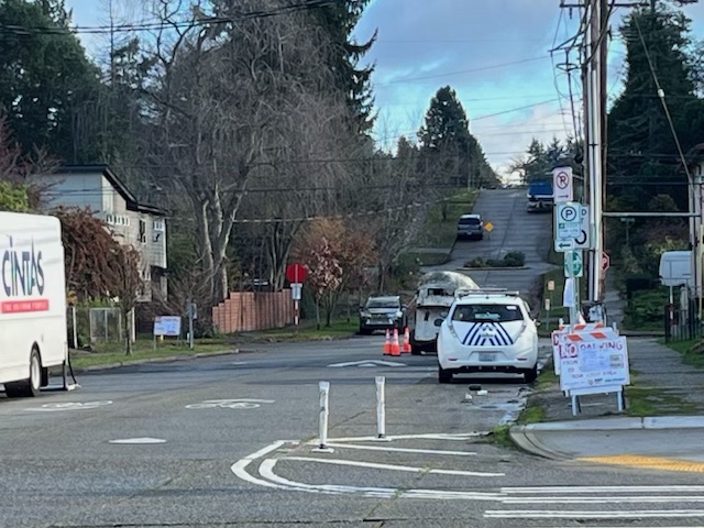
A few days ago, we noticed “no parking” signs up on SW Barton for today through Thursday, both sides of 16th SW, in an area known for RV camping. The city info-flyer attached to some of the signs listed the purpose as “remediation” – cleanup – as part of the Clean City program. On the day we saw the signs, RVs had already cleared out of the west block, but were still in view on the east side. So we went by to check this morning; no RVs in sight on either block, but city Parking Enforcement officers were there (above), and while we were there, a flatbed tow truck arrived, apparently for the livestock trailer left east of 16th:
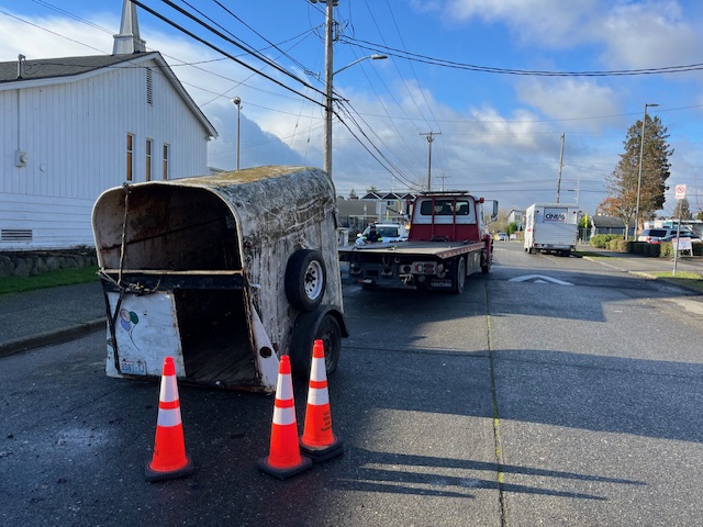
We’re following up with the city’s Unified Care Team.
| 19 COMMENTS