West Seattle, Washington
17 Sunday

5:28 PM: Thanks to Stewart L. for the photo of this afternoon’s rainbow. The National Weather Service‘s wind alert has now officially expired – no trouble reported during the blustery day – but the weather hasn’t settled down yet – if you were out just before dusk, you might have noticed the massive squall line to the west – here’s a view tweeted by @WestSeaWx:

Tonight’s outlook – breezy and showery, with “a slight chance of thunderstorms until early morning.”
6:04 PM: Daniel reports deep water on Harbor Avenue by Seacrest – beware! Also, the NWS says today’s high temperature was a record – 63 degrees at Sea-Tac.
ADDED 7:19 PM: Crews responded to handle the flooding. Meantime, Jon McAllister sent another view of the afternoon rainbow:

Be sure everything’s charged! The National Weather Service has a “Wind Advisory” alert for our area, 8 am-5 pm today, with the possibility of 25-35 mph wind from the south, gusting to 50 mph. Could be notably warmer, too, possibly reaching a high temperature in the low 60s.

A mostly gray day ended with some flourishes of color. Thanks to Gill Loring for the photo above. The sunset arrived as Southern Resident Killer Whales passed by, and Kersti Muul of Salish Wildlife Watch shared the next three photos:


Kersti says the paddleboarder is Brian, admiring K21 aka “Cappuccino.” Some shore-based whale-watchers too, as the day ended:

Now back to the weather – one headline tonight: That possible windstorm we mentioned last night seems to have fizzled, the National Weather Service noted in its evening Forecast Discussion about half an hour ago. The Friday night storm will be windy, they’re predicting now, but nothing out of the ordinary for November in Seattle. The strongest winds that night are expected to be south of Olympia and along the seacoast.
 (Last Friday’s windblown waves at Alki, photographed by Marc Milrod)
That chilly north wind had barely stopped blowing when rumblings began about a POSSIBLE windstorm on the way this Friday night. No alerts so far, but weather-watchers have been talking about it. Cliff Mass, for one, wrote about it last night, but he warned of “considerable uncertainty.” And even in tonight’s Forecast Discussion, the National Weather Service notes “confidence in wind potential remains low” regarding the storm. (Its Seattle main page currently features the phrase “Wind event possible.”) As with most forecasting around here, things seem to be – pardon the phrase – up in the air until a day or two out. But we’re mentioning it so you can be mindful of charging and other preparations, always smart at this time of year anyway.
 (Photo by Kersti Muul)
Another day of waves and spray at Alki – as a fierce north wind continued to blow. But fans of calmer weather will be happy to hear it’s on the way out.
 (Photo by Kersti Muul)
Tonight, the forecast says, the wind is expected to shift and slow, to 10 mph from the east. Then tomorrow and for the next few days, it’ll be out of the south/southwest.
 (Photo by Gabriella Jeakle)
While the wind speed is falling, so is the temperature – might be below freezing tonight.
 (Mt. Baker from West Seattle – photo by Lynn Hall)
The views like these are on their way out too – with clouds due to return tomorrow afternoon.

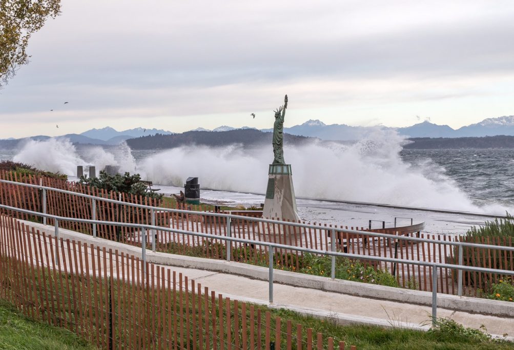
11:10 AM: Thanks to Marc Milrod for the photo above – received just as we noticed the wind-fueled waves while passing through Alki. We stopped for a quick clip:
Wild waves at Alki. pic.twitter.com/OnrSHnLf6i
— West Seattle Blog (@westseattleblog) November 6, 2020
This is from the northerly winds that canceled the West Seattle Water Taxi run this morning. The National Weather Service says gusty north winds will continue all day. Also in view from Alki – snow on the Olympics, as photographed by Stewart L.:

And another Alki angle from Marc:
With all this clearing, the NWS says sunshine’s on the way for the rest of today and much of the weekend.
11:56 AM: Two more photos just in – this one from a reader who says, “Our family took advantage of our break during school to learn about weather”:

And from Laurie Johnston:

 (Photo from seattle.gov)
Another fall tradition – keeping leaves from clogging storm drains. In November – which (in case you’ve lost track) starts tomorrow – Seattle Public Utilities allows customers to put out up to 10 additional bags of yard/food waste at no extra charge. (Monday update: We confirmed that this HAS changed from past years – it’s now 10 extra bags PER COLLECTION DAY.) The city sent this reminder:
Here are ways to manage fallen leaves:
1. Rake leaves and put them into your yard waste cart. If you have more than will fit into the cart, place extras in a compostable lawn and leaf bag or a reusable container with a lid. Put them out next to your yard waste container on collection day – no plastic bags.
2. Place raked leaves on bare soil as mulch in your landscape and garden. This conserves water, controls weeds and fertilizes the soil. Contact the Garden Hotline to learn more – 206-633-0224 or visit gardenhotline.org.
You’re also reminded that if you’re clearing storm drains, “stand on the curb, not in the street,” and leave the arterial drain clearing to the city – if it’s non-urgent, you can report it online; if it’s urgent – as in, a blocked drain causing flooding – call 206-386-1800.

11:29 AM: On this breezy Saturday, with wind out of the north up to 25 mph, readers have sent these two sightings – above, from Julie, a fallen tree in Schmitz Park, “blocking the trail that leads up to Hinds Street”; below, via text, a toppled toilet at Alki Beach:

The forecast says it’ll stay breezy most of the weekend. The alert for tomorrow, meantime, has changed to a Frost Advisory, 2 am-10 am Sunday, with the morning low possibly dipping into the upper 20s.
P.S. Both of the above are an example of what you can also call in to the Seattle Parks maintenance line to be sure they know too – 206-684-7250.
ADDED 1:50 PM: One more breezy scene – Jerry Simmons caught a kiteboarder off Alki:

 (Wednesday at Alki – photo by Theresa Arbow-O’Connor)
Back on Tuesday, we warned you that the first freezing forecast of the year was on the way. Now the National Weather Service has an official alert about it, issuing a “Freeze Watch” for Sunday morning, 2 am-10 am. That means, the NWS says, “Sub-freezing temperatures of 27 to 32 degrees (are) possible.” Highs Sunday and Monday will be in the 40s, then warning to the 50s on Tuesday, the forecast says.
 (Alki Lighthouse – photo by David Hutchinson)
One month into fall, a hint of winter is on the way. The forecast for this weekend brings the first low-30s lows, and even a mention of frost Sunday morning.
 (Lincoln Park – photo by Susan Romanenghi)
The big cooldown starts tomorrow – highs might not get out of the 40s again until next Tuesday. Last October, we didn’t get to freezing, but we got close – a 33-degree low on October 30th.

4 PM: Thanks for all the tips – power’s out over what seems to be a wide area of West Seattle – so far reports include Alki, Admiral, Avalon/Genesee – updates to come. And remember that a dark traffic signal (we’ve heard California/Admiral and 35th/Avalon and Delridge/Genesee are out, among others) is a 4-way stop!

4:05 PM: Also via scanner, trees are reported down in the 1500 block of Ferry and 7100 block of 31st SW (photo added above – came down right between two cars) . … City Light map has just updated, 6,700+ customers out.
4:16 PM: Ferry Avenue is blocked because of the tree trouble. Screengrab of City Light map added above. … Police radio indicates there are also lines down at California Way/Harbor.
4:28 PM: Multiple reports of an explosion-type sound in the Fairmount Playfield area after the initial outage started – looks like that area now has a pocket outage of its own, 91 customers:

4:46 PM: The National Weather Service still has the Wind Advisory alert set to expire at 6 pm. Peak gusts so far today have included 48 mph at Sea-Tac. Meantime, the City Light map shows several small pocket outages in addition to the 6,700+ and 91 out in the ones we’ve mentioned.
5:12 PM: Thanks to Susan Elderkin for the photo of tree branch vs. fire that led to the Fairmount outage:

That is in the 5400 block of 40th SW. … Thanks to Jamie Kinney for sending video of wind-fueled waves along West Seattle’s west-facing shores – first, Lowman Beach:
Next, Constellation Park:
5:36 PM: Note that some businesses are affected, particularly in the Admiral Junction. In comments, Shelby says Admiral Safeway is open though out of power – refrigerated/frozen items aren’t being sold right now, so the cases can remain closed.
6:48 PM: Just drove through much of the outsge zone – Admiral Junction businesses and traffic signals dark, though the power picks up again at California/Lander. The wind has calmed.
7:01 PM: Re-checking the SCL map, we noticed there’s also a pocket of 454 out at the east end of the SW Roxbury corridor, so we’ve updated the total out in West Seattle to 7,200+.
8:01 PM: No updates yet. While we always warn that SCL’s “estimated restoration time” is a useless guesstimate, even that hasn’t been updated, nor has the cause, though the crews seem to be focused on Ferry Avenue. We couldn’t get close to the scene but have received these photos – first, from Treehugger:

There’s also a pole down in the area:

Here’s where the road is closed:

(Thanks to Susanna Moore from longtime WSB sponsor Niederberger Contracting for that photo.) SCL says it’s handling 60 different outages throughout its service zone. Meantime, though the wind has lessened, it was still enough for some sunset surf at Alki:

Thanks to Samantha Lazar – a teenage volleyball player who was practicing at the beach at sunset, despite the wind – for the photo.
8:44 PM: Getting word in comments and via texts that many if not all have just come back online. The map may lag ~15 minutes in accurately reflecting who’s still out, so thanks for the updates!
9:01 PM: The map is updated. Still 1,000+ out scattered around West Seattle – primarily the tip of the peninsula plus that pocket at the east end of the Roxbury corridor.
10:04 PM: No change in the past hour. Below is the map of who’s still out, for the record – most of the markers in West Seattle are single-digit outages, except for the two in the north, and the pockets in Fairmount and Myers/Olson.

11:20 PM: One of the north-end pockets is back, so we’re now at about 800 out around West Seattle after 7 1/2 hours.
12:46 AM: Checked the map and almost everyone’s back on, in West Seattle.
6:49 PM: The National Weather Service has a “Wind Advisory” alert in effect for our area noon-6 pm Tuesday. What it’s currently forecasting:
* WHAT…Southwest winds 20 to 30 mph with gusts 45 to 50 mph expected. …
* IMPACTS…Gusty winds could blow around unsecured objects. Tree limbs could be blown down and a few power outages may result.
See the full text of the advisory here.
ADDED TUESDAY MORNING: The wind advisory moved ahead a few hours overnight – it’s now in effect 8 am-6 pm Tuesday.
If you bought a ticket, you’ve probably already received word, but just FYI, the West Seattle Chamber of Commerce has postponed tonight’s park-and-watch movie to next Friday (October 16th), since we could see rain before dark tonight. The CofC also has a few tickets left for the screening of “Secret Life of Pets” in the South Seattle College (WSB sponsor) north lot – go here.

6:16 PM: That was the view from Alki Avenue late this afternoon, as smoke from the south arrived. But the National Weather Service says it will not be anything like what we experienced earlier this month:
Smoke from California fires is making its way into Western Washington. This smoke will mainly be aloft and the air quality index is expected to remain in the good category. The skies are expected to become hazy starting this evening.
One of the newer large fires in Northern California is ravaging wine country north of San Francisco.
ADDED: Two views of the slightly smoky sunset – from Dan Ciske:

And from Vanessa Carr:


Thanks for the photos of the last summer sunset of 2020! Above, from David McDorman; below, from Jan Pendergrass:

Fall arrives tomorrow at 6:30 am; 12 hours later that, watch autumn’s first sunset virtually with Alice!
 (This morning’s fog, photographed by Ben)
Yes, that’s fog this morning, not smoke. Even once the fog clears, it’ll be cloudy, the forecast says, but we might see some sun tomorrow. Along with three weather photos from this morning and last night, a few notes:
 (Last night’s sunset, photographed by John Bartell)
TASTE OF WEST SEATTLE: This is the second of five days for this year’s Taste of West Seattle, with partner food/drink establishments donating.part of the proceeds from certain menu items to the West Seattle Food Bank, to help prevent hunger and homelessness. See the list of participants (and the menu items) here.
(added) DRIVE-UP FLU SHOTS: All Seattle Public Schools students, families, and staff are welcome at today’s 10 am-5 pm drive-up flu-shot clinic at Chief Sealth International High School (2600 SW Thistle). You need an appointment – the link is here (as well as the list of other schools hosting these in days ahead, including others in West Seattle).
PEACE DAY: From Admiral UCC Church: Today “is International Peace Day. Come together for Peace. Draw, paint or photograph the symbol of peace, a dove, and post it online and in your window. We will be having a display of art at the Admiral Church grounds (today) for people to post their images of Peace there for all to enjoy. Won’t you join us! Admiral church is at the corner of California Ave SW at SW Hill St. We hope there will be many illustrations of peace displayed there. There will be twine strung between the trees for you to tape your pictures or cutouts onto. This is a great way for families to participate.”
 (Last night’s moon, photographed by Chris Frankovich)
T-SHIRT DEADLINE: As noted last night, today is the final day for orders in the next round of sales of the contest-winning West Seattle Bridge T-shirts. Here’s how to order.
 (Wednesday photo by Suzanne Murray)
Dare we hope that this will be the final extension? The National Weather Service, in consultation with other regional agencies, has extended the Air Quality Alert, this time until 10 am Saturday. Some cancellations/closures continue – city parks are still closed today, Seattle Public Library curbside service is canceled today, and the twice-weekly BLM sign-waving at 16th/Holden is canceled again today too, per organizer Scott.
 (WSB photo)
6:33 PM: For the first time in days, we saw a hint of the downtown skyline from Seacrest while out on late-afternoon errands. Looking to the west, the sun was pink through the smoke/fog – we didn’t photograph that, but Marc Milrod did:

Dare we hope the worst is past? The latest “forecast discussion” says cautiously, “A front moving through the area late Thursday into Friday is expected to help clean out some of the smoke.”
ADDED 8:56 PM: Thomas just sent this photo of what the smoke looks like from above – that’s Mount Rainier barely poking through in the distance:

 (Looking toward the smoke-obscured downtown skyline – photo by Marc Milrod)
You might have given up trusting forecasts by now, since we’re still socked in by smoke. But if not – here’s what forecasters are saying: “Relief from smoke will come in the form of an upper-level trough moving onshore late Thursday into Friday, bringing widespread rain that should help clear out the smoke.” So don’t expect relief tomorrow. Couple of interesting side notes from the Washington Smoke Information website: First, if it’s any consolation, this isn’t the longest smoky stretch we’ve lived through in recent years, though it does top one disturbing category. Also: If you’re wondering about which fires this smoke is from – look south, not east.
P.S. If you’re watching the numbers, readers shared their favorite sites in this thread earlier today.
Rain isn’t always big news, but when it happens after days of sky-shrouding smoke, it is. So in case you can’t believe your ears, we’re verifying – that’s rain. We’re hearing it here over Lincoln Park; Gill in White Center reports it there too. Might not be enough to clear things up – warns the Weather Service – but it’s certainly welcome.
 (Monday morning photo by Stewart L.)
10:12 AM: Monday morning and still smoky. Two notes for starters, and we’ll add anything else of note related to the smoke in the hours ahead:
SEATTLE PARKS: As first reported here last night, parks, playfields, boat ramps, golf courses remain closed today because of the unhealthy air. (Added: The closures have now been extended through Wednesday.)
SEATTLE PUBLIC LIBRARY: Curbside service is suspended again today.
(added) CITY-RUN COVID-19 TESTING SITES: Closed today, including the one at Southwest Athletic Complex.
(added) MADISON MS TEXTBOOK/MATERIALS PICKUP: Canceled for today.
Other closures/cancellations? westseattleblog@gmail.com or text 206-293-6302 – thank you!
ADDED 11:36 AM: Though the air-quality alert has expired for now, an update from AlertSeattle notes, “Wildfire smoke making air quality ‘very unhealthy’ to ‘unhealthy for sensitive groups’ is expected to remain in the area through the middle of this week.”
1:50 PM: The expiration didn’t last long. There’s a new air-quality alert in effect through noon Thursday.
 (One of the sun’s brief appearances this weekend – photo by Ron Creel)
Two notes as this smoky weekend concludes:
CITY PARK CLOSURES: Seattle Parks announced via Twitter tonight:
Due to ongoing poor air quality, we’re extending closure of beaches, boat ramps, parks, & playfields through end of Mon., 9/14. The City is not issuing citations, but all residents are strongly encouraged to avoid outdoor activities & remain inside if able until quality improves.
SO WHEN WILL IT IMPROVE? Maybe not as soon as originally forecast. From the National Weather Service‘s “forecast discussion” tonight:
Stubborn smoke continues to hang on around most of Western Washington with unhealthy air quality expected to linger into Monday. Surface gradients remain light and this will do little to disperse anything across the lowlands. A broad upper trough offshore will send a weakening frontal system into the region Monday night into Tuesday, but models are backing off considerably with precip chances.
Any other changes/closures for Monday? Let us know so we can include in our updates – thank you!
 (This morning’s sunrise, photographed by Marc Milrod)
Last night, as we reported, the National Weather Service said the wildfire-smoke-fueled Air Quality Alert would probably be extended – and now that’s just happened. It’s in effect until 11 am Monday. The alert notes, “Expect conditions to be worse during the overnight hours through this period as calmer winds will allow smoke to settle.” And @WestSeaWX adds:
It's going to get bad this weekend, see attached smoke model.
Onshore flow will push all of the smoke to our south and west into our area over the weekend, esp on Saturday pic.twitter.com/aaMKpV0eEi
— WestSeattleWx (@WestSeaWx) September 10, 2020
| 1 COMMENT