
West Seattle, Washington
30 Saturday

Before tonight’s full moonrise, this morning brought a beautiful almost-full moonset. Thanks to Chris Frankovich for the photo above and James Bratsanos for the photo below. No weather alerts tonight, but morning lows are still expected to drop into the 30s until clouds and rain return, currently forecast for Tuesday/Wednesday.

Tomorrow’s moonset is 8:59 am, so it’ll be a little too light for views like those.
ADDED: Tonight’s full moon, photographed by Jerry Simmons:


2:29 PM: Thanks to Lynn Hall for that photo of the Olympics this morning, seen in their fall/winter coat (of snow) for the first time this season. Here in the lowlands, colder weather is approaching, and the National Weather Service has issued two alerts: a Frost Advisory for midnight tonight until 9 am Friday, a Freeze Watch for late Friday night through Saturday morning. The NWS explains: “For the Frost Advisory, temperatures as low as 34 will result in frost formation. For the Freeze Watch, sub-freezing temperatures as low as 30 (are) possible.”
P.S. Also remember that the cold weather means West Seattle’s volunteer-and-donation-powered emergency shelter is opening – we’ll be checking back to see what’s still on the wish list.
3:51 PM: One more great view of the snowy Olympics, this one sent by David Hutchinson:


It was a day full of off-on rain … but also multiple rainbow sightings. Thanks to everyone who sent photos! Above, an end-of-day Alki photo from Lisa Murphy; below, from Robin Sinner:

Stewart L. captured the downtown skyline beneath a rainbow:

And Manuel photographed the meeting of rainbow, state ferry, and cruise ship:

Still a chance of more showers through tomorrow, and then the forecast clears up for a while, possibly sunny and near 70 degrees on Thursday!

Thanks to Murphy McCullough for the photo from Upper Alki! Amazing clouds this past hour or so as another storm wave sweeps through. The forecast calls for continuing unsettled weather – possibly some thunderstorms in the hours too.
ADDED TUESDAY EVENING: We also got a different angle from Dan Ciske:


Thanks to Jan Pendergrass (above) and James Bratsanos (below) for the photos of Labor Day Weekend 2023’s first sunset.

The forecast says tomorrow will be the sunniest, warmest day of the weekend, with a high near 80. Then the cooler, cloudier weather rolls back in.
 (Sunset from Lincoln Park – WSB photo by Patrick Sand)
The weekend “heat advisory” alert has expired as of 8 pm, and the forecast suggests we’re on track for a cooldown, with a high in the 70s tomorrow, the 60s Tuesday – when, the National Weather Service says, “temperatures will be their coolest since June” – and possible showers/thundershowers inbetween. In the meantime, some smoke lingers, as air-quality readings underscore.

6:50 PM: If you have a westward view like the one we photographed from Emma Schmitz Memorial Overlook, you know the Olympics have gone temporarily missing again behind a smoky haze. This time, it’s smoke drifting down from British Columbia as the wind blows out of the north. Air-quality readings (like these on PurpleAir) show the results, but nothing like the last round, and so far, this time it’s not expected to get to alert level, and there’s even a chance of showers tomorrow morning.
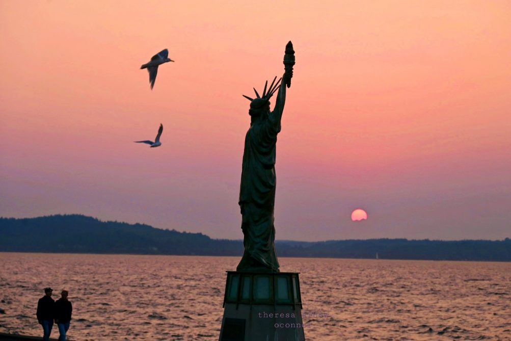
8:58 PM: Another sign of smoke – the sunset. Here’s how Theresa Arbow-O’Connor caught it from Alki Statue of Liberty Plaza:
 (From Fauntlee Hills – photo by Scott Wiesemann)
Thanks for the photos. Though the official sunset moment is right about now, the sun made an early exit tonight, shrouded in smoke after casting a pink shimmer on Puget Sound.
 (Photo by Beth Jackson)
The National Weather Service says the wind has shifted in a way that should keep air quality from getting any worse, though it may take a while to “scour” the air. By Tuesday, there’s even a slight chance of rainshowers.
2:33 PM: The season is over a bit early for the EC Hughes wading pool, which was scheduled to have its last day of the season today. Seattle Parks and Recreation just announced all of its wading pools citywide will be closed for the rest of the day – including daily-operation pools such as Lincoln Park – “due to the poor air quality.” No other aquatics closures have been announced so far.
7:58 PM: For the record, Parks announced belatedly that it had closed other outdoor aquatic facilities early including Colman Pool.
 (Photo by David Hutchinson – tonight’s sunset as seen from Alki)
It’s a sure sign of smoke – the sun appeared pink through the haze. We’re still under an air-quality alert until Monday morning, and readings show things have definitely worsened. The Washington Smoke Information site says this is smoke both from fires to the east and from fires in southern British Columbia.
 West Seattle’s emergency shelter – which runs on donations and volunteer help – is open for the hot weather, its manager Keith Hughes tells WSB, until 8 pm today and again 11 am-8 pm tomorrow “with food, water, and AC. However, we are very low in supplies, so I have attached my Supplies Wish List. Also, keeping the hall open and running the AC for days is a strain on our finances, which are all voluntary donations from the community. Pepple can donate items from the Wish List, or go to our website, westsideneighborsshelter.org and make a cash donation [update: direct link here] to help with the electric and water bill.” Here’s the wish list:
Food Pantry
Ground Coffee (Folgers 3# cans)
powdered coffee creamer (like Coffeemate)
Instant Hot Cocoa Mix (for hot water)
Bottled water
Soft drinks in cans (store brands and things on sale)Instant Oatmeal packets
Granola-type low-sugar cereal
Pancake mix, Bisquick mix
Pancake syrup, butter, jam
Canned soup, chili, beef stew
Packaged food like top ramen, Cup-o-NoodlesRice-a-roni, noodle-roni boxes
Dry pasta (spaghetti, egg noodles, macaroni )
Spaghetti sauce in jarsFood store gift cards so we can get fresh things like milk, eggs, butter, meat
Other Needs
Travel-size individual soaps, shampoo; tooth brushes & toothpaste (ask your dentist for donations) bar soap for shower, laundry detergent pods
Toilet paper and paper towels, disinfectant wipes
Single-bed-size blanket
The shelter is co-housed with the West Seattle Veteran Center/American Legion Post 160 at 3618 SW Alaska.
 Now that the heat is here – mid-80s at mid-afternoon – the National Weather Service has upgraded its alert to an Excessive Heat Warning. But it’s also shortened the duration; instead of stretching into Thursday, the NWS is currently expecting the alert to expire late Wednesday night. The alert warns of: “Dangerously hot conditions with daytime temperatures in the low to mid 90s and lows in the 60s expected. This will pose a major risk of heat-related illness.” Keep yourself hydrated (and if you have a bird bath, keep that full too).
 1:32 PM: You’ve probably heard the forecast for a heat wave next week. The National Weather Service has formalized it with an “Excessive Heat Watch” alert for Monday morning (August 14th) through Thursday evening (August 17th). The alert warns of:
.A multi-day stretch of dangerously hot conditions with daytime temperatures in the 80s and 90s and lows in the 60s. This will pose Moderate to Major Heat Risk levels and risk of heat-related illness.
As the map at right shows, the alert covers much of Western Washington,
4:13 PM: The alert’s been updated to kick in earlier – “late Sunday night.”

Thanks to Becky M for that photo of the sky as seen from Alki tonight. We asked @WestSeaWX what type of cloud formation the photo shows. The reply: “A nice comfy blanket of altocumulus clouds.” If you’ve been wishing for a clear sky and warmer temperatures instead, forecasters say you have just a few days to wait, and next week might even bring 90-ish-degree highs.
Three West Seattle scenes from August’s first Friday:

Above, James Bratsanos captured the colors of tonight’s sunset. … Below is Steve Pumphrey‘s photo of salmon seekers lined up along the north side of Point Williams at Lincoln Park:

And below, an image from today’s Blue Angels flight – Rainer Klett photographed a Space Needle flyby from Alki:

Saturday’s forecast has some clouds – maybe even a chance of an afternoon shower.

Thanks to everyone who sent photos of tonight’s smoky dusk – the one above is from Gene Pavola. Air quality is expected to remain “moderate” for the next two days; the National Weather Service says wildfire smoke from Canada remains the primary problem. Earlier, looking north, the air was clear when Jerry Simmons photographed this scene at Anchor/Luna Park:

And Ant sent this view of sea life during summer’s lowest low tide today:

Tomorrow’s low-low tide is almost as low – -3.8 feet just before 1 pm.
8:24 PM: Notice all the haze to the west this evening? The National Weather Service‘s forecast discussion notes that “some elevated smoke from fires in Canada may drift over the region, but this is not expected to significantly make it down to the surface.” While the air quality remains OK right now, the smoke forecast for the next two days shows it moving down into the “moderate” zone.

ADDED TUESDAY: Thanks to Jen Popp for that photo of the smoky sunset.
 (Photo tweeted by @i8ipod)
Thanks to everyone who sent photos of the rainbow that emerged between waves of rain late today!
 (Photo sent by Stewart L.)
The possibility of more rain remains in the forecast off and on until Wednesday – which is when summer arrives, with the solstice moment at 7:57 am. Then by Thursday, we should be back in the mid-70s – tonight, though, it’ll be cold, dropping into the 40s!
3:15 PM: The quality of the light outside is a bit reminiscent of late summer. That’s in part because of wildfire smoke that has drifted this way from Alberta. The National Weather Service tweeted a satellite image of the “high-level” smoke this morning, as well as photos of a redder-than-usual rising sun. Air-quality maps don’t show much trouble down here at ground level, though (here’s Puget Sound Clean Air Agency, here’s PurpleAir). The NWS’s latest forecast discussion notes, “Smoke should remain aloft with no major impacts expected at the surface but, could lead to a picturesque sunrise/sunset. For tonight, generally benign conditions are expected. … There’s a possibility we’ll continue to see more smoke/haze into Thursday but winds are showing signs of shifting.” As for the fires themselves, the CBC says almost 100 fires are burning in Alberta.

9:36 PM: It was definitely a summer-smoke type of sunset, as shown in David Hutchinson‘s photo, added above.

Thanks to Kevin Freitas for that photo of lightning seen to the east from his home near The Mount; he published more photos here. We’ve heard some thunder this past half-hour, and you might have notice thunderheads like this late in the day:

Jim Edwards photographed that formation looking east from Shorewood. Rosalie Miller caught pink clouds, looking south from Lincoln Park:

And to the west, the sunset was a spectacle. Thanks to everyone who sent photos – this one is by David Hutchinson:

All this followed another hot day – but the Heat Advisory alert expired as scheduled at 8 pm, and now we’re on to simply “warm” weather, though it’ll still be about 10 degrees above the normal mid-May highs in the upper 60s.
 Warm weather is returning and this weekend is currently expected to have summer-like weather – sunny, 80ish! That includes Saturday, which is this year’s West Seattle Community Garage Sale Day. On the second Saturday every May since 2005 – except for the pandemic years (2020 and 2021) – West Seattle becomes Western Washington’s garage/yard/etc. sale capital for a day. WSCGSD was launched in 2005; we at WSB have coordinated it since 2008. This year, more than 400 sales are registered for the first time, and you can preview the locations via the map/list, which we published this past Saturday – the online version here (be sure to use the plus/minus zooming to see all the sales in specific areas) and the printable list here. Official sale hours on Saturday (May 13) are 9 am-3 pm, but as you’ll see on the list, some sellers have chosen to add hours/days. Starting tonight, as we do each year, we’ll publish some lists – such as benefit sales, block sales, plant sales, art sales – as the countdown continues. (You can also search the map for keywords in sale descriptions – see those hints at the bottom of the map page.)
 (Added: Photo by Lori T)
8:10 PM: It would have been hard to believe when we heard it minutes ago, except that we had just been warned by @WestSeaWx on Twitter, that “scattered thunderstorms” are drifting this way, south/southeast to north/northwest.
8:17 PM: Lightning too! This is a few hours ahead of the National Weather Service‘s note about “slight chance of thunderstorms after midnight.”

10:13 PM: Thanks for the lightning photos! The one above was sent by Satori Noël. The one below is from Scott Collins:

11:27 PM: More photos! John Skerratt sent these from Fauntleroy:


And this one’s from Aaron Brethorst:

ADDED THURSDAY MORNING: Kevin Freitas sent his skycam video:

That photo was texted by a reader a short time ago, reporting a “crazy windstorm” at 3:05 am, noting, “I’ve never had our cans blown over in addition to all of the recycling blown all over the yard.” We were off watch by then so we missed it, but the National Weather Service notes “strong, gusty winds … with passing showers” around that time and the Sea-Tac wind gauge showing a gust up to 43 mph.
| Comments Off on WEST SEATTLE WEATHER: More cold nights ahead