West Seattle, Washington
03 Sunday

The rain has stopped – for a while. For the first time in two days, the National Weather Service has recorded an hour in Seattle with no more than a trace of rain. Despite 3+ inches Friday alone, no major problems in our area – but it’s definitely left its mark. Above, a reader just texted that photo of trees down across the bluff trail at Lincoln Park that leads to/from Colman Pool. (Slide risk is high because of the rain, so be watchful if you’re near a slide-prone slope.) Below, what Longfellow Creek looked like from the SW Yancy footbridge at midday:
Here’s how the creek looked Friday, as tweeted by Mark from a point a short distance south:
@westseattleblog Longfellow Creek near Dragonfly Pavilion pic.twitter.com/EJIXRxmUCC
— Mark Tiedemann (@pdxmark77) December 20, 2019
We’re off now to enjoy the break in the train by covering Alice‘s winter-solstice sunset watch (a quarterly tradition even when the sun doesn’ show up).
It’s back to business as usual at Duke’s on Alki today (2516 Alki SW) after repairs to a pipe that broke in subfreezing weather Friday morning. (That’s the situation that was logged as “major water job” on the SFD log, though their crews weren’t there for long.) Duke’s management contacted us this morning to get the word out that they have fixed the problem and are back open regular hours today, 11 am-11 pm.

If you missed the waxing crescent moon and its planetary companions just after sunset – here’s the view courtesy of David Hutchinson, who explains, “View from Constellation Park. Venus is closest to the Moon, with Jupiter further to the right and slightly down.” Tomorrow should bring a clear view, too; Friday’s moonset will be 7:15 pm, an hour later than tonight.
Wild waves indeed. pic.twitter.com/pzEh0h1sDV
— West Seattle Blog (@westseattleblog) November 27, 2019
4:28 PM: North winds and high tide combined for a show on Alki this past hour.
 (This photo and next by WSB’s Patrick Sand)
The forecast looks good – though cold – for Thanksgiving Day and Friday, sunny with a high near 40, but the s-word has crept back into the forecast for the weekend …
SATURDAY NIGHT…Mostly cloudy. A slight chance of rain and snow after midnight. Snow level near sea level. Lows near 30.
SUNDAY…Mostly cloudy. A chance of rain and snow in the morning, then a slight chance of rain in the afternoon. Snow level near 300 feet in the morning. Highs in the lower 40s.
Just a chance – and shortlived if it happens, the “forecast discussion” elaborates – but you are hereby forewarned.

6:45 PM: Photos added from this afternoon’s waves.
 (Photo by Theresa Arbow-O’Connor)
There could be a repeat tomorrow, as north winds are expected again; afternoon high tide is at 4:56 pm.

So grateful to Bob Bollen for capturing this and sending his photo – we spotted the big burst of color while driving in The Junction; turned westward in hopes of getting down to the water for a clear view, but it vanished too quickly.

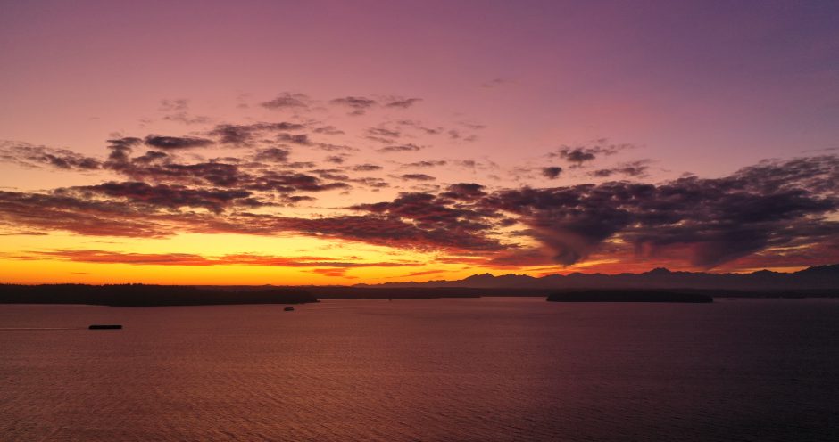
With hours to go until Daylight Saving Time ends (2 am Sunday, we “fall back” an hour), another stunning sunset. Thanks for sending photos! Above, from Kersti Muul; below, from Kath Dedon:

No rain in the forecast until late next week.

(WSB photo, Alki slide in 2013)
Though our current run of dry weather might lull you into complacency, now that it’s November, it’s landslide season – and West Seattle is often a trouble spot, with so many slopes. Here’s a seasonal reminder from the city:
Did you know that most landslides occur between the months of November and March? As snow melts and rainfall continues to increase throughout the winter, the threat of landslides will continue to rise.
Landslide season is approaching, so the City of Seattle is urging residents to take preventive measures to protect themselves and their property from possible landslides.
Most landslides are caused by water (e.g. rainfall, uncontrolled stormwater) or human activity that increases the weight at the top of the slope or reduces the stability at the bottom of the slope.
With 20,000 Seattle properties (mostly residential) in landslide-prone areas, Seattle’s Department of Construction and Inspections (SDCI) encourages property owners to take preventive measures to protect themselves from landslides by:
Checking downspouts; making sure they are functioning/routed to a safe location
Maintaining drainage systems by clearing away leaves and debris
Inspecting sloped areas for indications of soil movement and erosion
Shutting off irrigation systems and inspecting them seasonally
Keeping fill and yard waste off slopes
Knowing when to seek professional help for hillside projectsVisit our Emergency Management website to understand if you’re at risk and how to be prepared.
Helpful tools include:
Landslide tutorial
Interactive GIS Map
Landslide Prone Area Map
Do’s & Don’tsIf a landslide damages your property and you have an immediate concern for your safety, leave the premises and call 9-1-1. Seattle property owners with structures that may be affected or endangered by a landslide should also contact SDCI at 206-615-0808 so that a building inspector can respond and perform an initial assessment of the structure.
Visit the USGS website to view the current conditions of the USGS rainfall threshold for landslides.
Early next year we will be providing presentations on landslide awareness during our annual Seattle Home Fair in north and south Seattle. More information will be shared in the coming months.
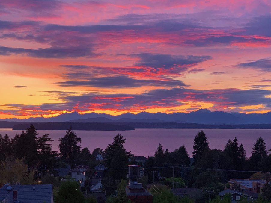
Thanks to Jamie Kinney for sending the photo of tonight’s sunset! By the end of this weekend, the sun will be setting before 5 pm, since we “fall back” an hour at 2 am Sunday. (You can always check the sunset/sunrise/moonset/moonrise times on the WSB West Seattle Weather page.)

That photo texted by a reader on Gatewood Hill shows a reading below 30 degrees early this morning. Just south of the Gatewood line, our birdbath froze over. Tomorrow morning will be even colder – possibly into the mid-20s. Any pre-winter prep you haven’t done yet, might be a good time to get it done. The dry weather will continue through Halloween – still cold Thursday night but probably about 10 degrees up from tonight.
 (Photo by Chris Frankovich)
Thanks for the photos from tonight’s sunset! One West Seattleite even sent an aerial view:
Coming in for a landing at SeaTac on @United Flight 1641 from Chicago and #IACP2019. Lake Washington foreground, then Seattle downtown and Elliott Bay (center) with West Seattle to the left. Then Puget Sound, Bainbridge Island and the Olympic Mountains distant. @westseattleblog pic.twitter.com/mzXgWTF8vE
— Bill Schrier (@billschrier) October 28, 2019
Two things worth noting:
-This was the last Sunday of Daylight Saving Time this year; 2 am next Sunday (November 3rd), we “fall back” an hour and move into Pacific Standard Time.
-If you have a vehicle parked outdoors, you might need your ice scraper. Tonight’s low is forecast in the 30s, then possibly into the 20s Monday and Tuesday nights.
 (Photo by Marc Milrod)
Surf’s up in West Seattle @westseattleblog pic.twitter.com/dV7e3mUDU3
— Ron Creel (@roncreel) October 26, 2019
Thanks to Ron for tweeting the video from Alki as this afternoon’s high tide approached, with wind out of the north. Good news – the clear weather is forecast to continue tomorrow (West Seattle Junction Harvest Festival and Fauntleroy Fall Festival day) and maybe even on through Halloween!
4:37 PM: Thanks to JayDee for the photo:

 (Added: WSB photos)
6:56 PM: The thunderstorms that moved through this past hour have done some damage. Seattle Fire is on scene in the ~10700 block of Marine View Drive SW, where residents report lightning hit multiple houses; no fire, but some damage is reported. In that area, more than 200 homes are without power, according to the City Light map.

7:56 PM: We’ve been to two of the homes with lightning damage.

In both cases, glass was broken, but no one was hurt.

Some tree damage too. At one home, the damage was focused on a detached dwelling unit which had no one inside at the time.

9 PM: Photos added. The residents report the lightning strike was colorful – they saw red at one point – as well as powerful.
12:33 AM: Could be more overnight, says @WestSeaWx.
 (Photo by Robert Spears)
What a way to wrap up the first weekend of fall! Thanks to everybody who sent photos.
 (Photo by Kanit Cottrell)
This view reveals the moon:
A 1 percent illuminated moon setting over the Olympics tonight. @westseattleblog @NWSSeattle pic.twitter.com/7GwLJyvReh
— Ethan Owens (@Twixted1) September 30, 2019
And a panorama:
 (Photo by James Bratsanos)
One more closeup:
 (Photo by Tom Stoner)
The National Weather Service says some clear weather is on the way – if the Olympics indeed are in full view, you’ll see fresh snow!
Texter says a tree is down in the southbound lanes of Admiral on the hill north of the West Seattle Bridge.
Fall doesn’t officially arrive until next Monday (equinox moment at 12:50 am September 23rd) but tomorrow’s weather will be autumn-ish – south wind up to 30 mph in the afternoon, not major but potentially strong enough to cause some trouble, especially this time of year with leaves still on the trees. Rain will precede the wind, so check your nearest storm drain(s) too.

8:35 PM: Thanks for texting the photo from Alki! We were not sure about the extent of the storm – until a big flash and loud thunderclap outside the meeting we are currently covering in White Center. No National Weather Service alerts this time, though. Monitoring …
8:47 PM: Six major thunderclaps heard so far.
9:54 PM: Back in West Seattle. Storm seems to have passed, for now. One more cool visual:
240fps slowmo vid of a lightning flash tonight around #Seattle. #wawx @NWSSeattle @westseattleblog pic.twitter.com/qrtB8zfUae
— Kevin Freitas (@kevinfreitas) September 13, 2019
 (Saturday night photo by Roy Wilkie)
3:45 PM: 18 hours after that incredible thunderstorm moved through (WSB as-it-happened coverage here), some damage has yet to be repaired. The Seattle City Light map shows the biggest outage in Fauntleroy is finally over, but other pockets east of The Junction and in the Beach Drive area. Some have also noted cable/internet outages too; Dustin emailed to say he’s been out of Comcast service most of the day and their outage map shows stretches of the Fauntleroy and Roxhill areas are out. And at least one traffic signal was still affected – 35th and Henderson – when we went through around 1:30 pm:
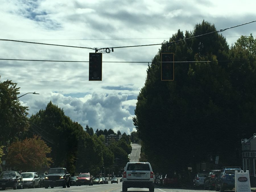
Please remember that a malfunctioning traffic signal means the intersection is an all-way stop. Meantime, be aware that the forecast says there’s a chance of thunderstorms again tonight and/or tomorrow. For now, though, some sunshine, and a rainbow just photographed by Melissa Kegler:

And if you’re interested in a little more scientific detail about what happened last night, weather analyst Cliff Mass updated his storm post.
9:28 PM: Thanks for the updates in comments. Surveying the pockets still on the City Light map, looks like 150 or so customers are still out in West Seattle, after 24 hours; the biggest pocket is near 35th/Alaska. SCL tweeted earlier, “Due to the large number of scattered outages throughout our service territory and the amount of equipment that needs to be replaced, restoration time may take longer than usual.” Though fewer than 1,000 customers remain out in their service area, that’s distributed among 134 separate outages.
 (Lightning over Elliott Bay, photographed by Mark McAndrews)
8:08 PM: Lightning, thunder, downpour. Power flickers too but nothing on the City Light map so far. In a short-term forecast alert, the National Weather Service says this could go on another hour or so.
8:18 PM: Two spots now mapped with outages – 35th/Barton (Upper Fauntleroy to the west of there) and The Arroyos. … Lots of tweets capturing the sights and sounds, like this one:
West Seattle skies awakening @westseattleblog #wawx pic.twitter.com/1OXF6aFEi1
— Casey Agena (@AgenaCasey) September 8, 2019
And this:
definitely close!! pic.twitter.com/flBMdBT4fh
— Megan (@megancontagion) September 8, 2019
8:34 PM: Thunder and lightning continue. More scattered outages on the City Light map in several West Seattle spots, with at least 200 out.
8:48 PM: Adding more visuals – thanks to everyone who’s emailed, texted, tweeted. (First clip below is from Paul Nicholson:)
@westseattleblog @NWSSeattle High Point West Seattle looking west pic.twitter.com/tn72B7FHx8
— Brad McDonald (@GrizzliUK) September 8, 2019
Per scanner, signal now out at 35th/Alaska.
9:04 PM: The NWS says the area had 200+ lightning strikes between 8 and 8:45 pm.
9:22 PM: Here, screengrabbed from the SCL map for posterity, are all the spots with outages – adding up to 200-ish customers (residences/businesses) best as we can tell:

Region-wide, SCL has 101 outages mapped right now affecting 1,100+ customers. And the thunder continues!
9:33 PM: Commenter Michelle says her flight into Sea-Tac was diverted to Bellingham because of the storm. And via Twitter, Tony says his flight from Billings was diverted to Spokane.
9:52 PM: Sounds like (from the lack of thunder) the storm might finally have moved on. Meantime, a few pets have been lost/found during the storm – we’re adding listings to the WSB Lost/Found Pets page as they come in.
10:54 PM: SCL says it’s working to get to all the outages – the number of which has increased since the storm moved north. Meantime, more photos – first, from Marc Milrod:

And from Kersti Muul:

The NWS now counts the number of lightning strikes in Western Washington at ~1,250 over 3 1/2 hours.
2:35 AM: Adding up the numbers on the many mapped pocket outages around West Seattle, looks like about 400 customers are still without electricity.
12:26 PM SUNDAY: And they’re still out. SCL’s map now shows 174 individual outages around its service area, totaling more than 1,400 customers.
9:34 PM SUNDAY: We’re tracking continuing outages here.
Thunderstorms are rolling through the region. A texter says outdoor Colman Pool has closed early as a result. Right now, just light rain and dark clouds, but we’ll keep watch in the hours ahead.
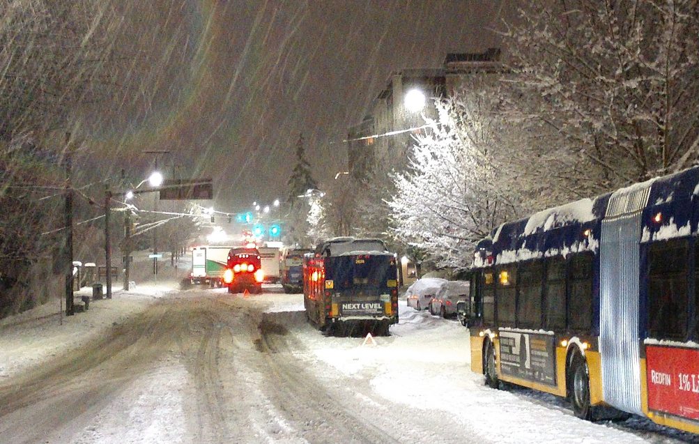 (Photo from February snow, courtesy Jeff B)
Back in April – when we were only two months removed from this year’s February snowpocalypse – we reported on the King County Council considering waiving Metro fares during that kind of weather. Today, on an extra-warm late-summer day, councilmembers finalized the plan. Here’s the announcement:
Today the Council approved legislation sponsored by Councilmember Jeanne Kohl-Welles that would waive enforcement of Metro transit fares when Metro activates its Emergency Snow Network to encourage people to use transit and avoid driving during severe snowstorms.
The legislation was approved 7-2 with Councilmembers Claudia Balducci and Kathy Lambert voting in opposition.
Metro customers will be able to ride without paying the transit fare while the Emergency Snow Network is in effect. The legislation increases accessibility of Metro transit service for those experiencing homelessness in need of shelter and encourages all residents to avoid driving during severe snowstorms.
“Like our policy of free fares on New Year’s Eve, this legislation is about promoting safety,” said Kohl-Welles. “It will encourage people to stay off the roads and get to where they need using a safer mode of transportation – regardless if they have an Orca Card or enough money to pay the fare.”
The measure was proposed earlier this year by Kohl-Welles in response to a massive storm that devastated roads and highways across the region in February and became known as “Snowmageddon.” This resulted in Metro activating the Emergency Snow Network for the first time.
A memo accompanying the legislation projects this could “potentially cost Metro approximately $64,750 per day during a snow event warranting enactment of the Emergency Snow Network.”

Thanks for the photos of the post-sunset glow on this late-summer Tuesday! Above, a panorama from Jamie Kinney in Fauntleroy (click the image to see a wider version); below, an Olympics silhouette from Lynn Hall on Alki:

Another warm, sunny day tomorrow!
Thanks for the tip on this rainy (but expected to lighten later) morning! Texter reports a tree branch down in the southbound lanes of Admiral Way near City View. They’ve called SDOT (206-386-1218 is the 24-hour trouble line) and were told a crew’s on the way.
 (New moon, photographed from Alki Point by Jim Borrow)
Whether you love or loathe hot weather, brace yourself for another round – the forecast for Sunday now says we could get into the 90s. The last 90-or-hotter high temperature was 91 degrees on July 21st; before that, 95 on June 12th.
| 7 COMMENTS