West Seattle, Washington
09 Thursday
 (WSB photos by Patrick Sand)
Right about the time of today’s winter-solstice moment – just before 2:30 pm – the sun emerged to greet the newly arrived season. And it hung around long enough for squinting and sunglasses to be in order at NASA volunteer Solar System Ambassador Alice Enevoldsen‘s sunset-watch event at West Seattle’s Solstice Park.


The park has paths and markers that align with solstice/equinox sunsets, and the dozens in attendance were able to fully appreciate them today.
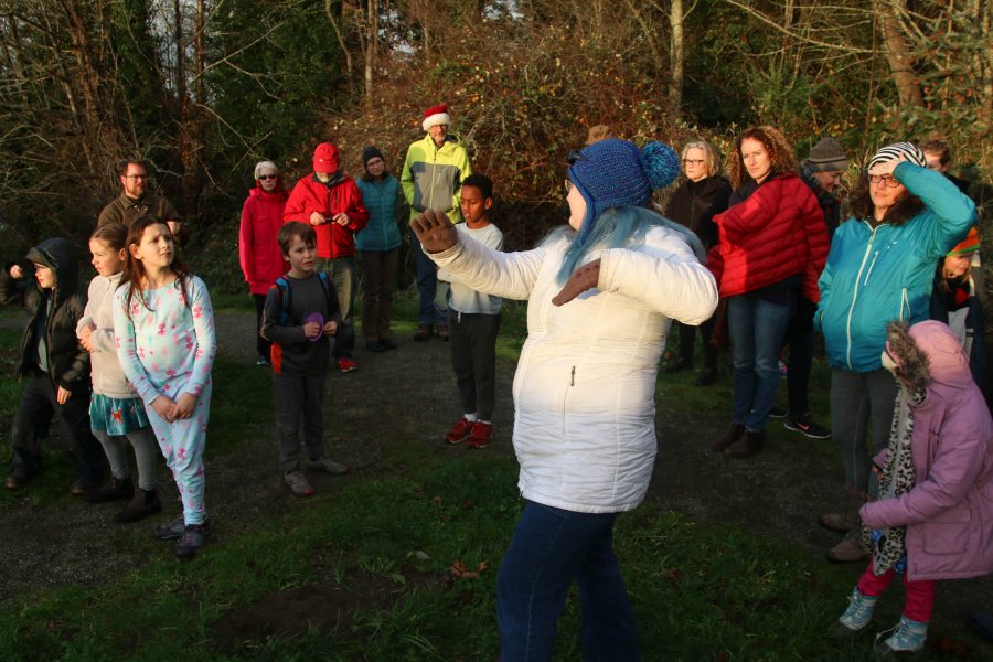
Sunset watch also means a lesson about the Earth, the Sun, and how the solar system works.


Now that the days are going to start getting longer – just a tiny bit at first, Alice noted when asked, so don’t get too excited yet – you can start looking forward to the spring equinox, just before 3 pm on Wednesday, March 20th, so plan on sunset watch with Alice a few hours later.

(WSB file photo)
The weather should be a lot calmer on Friday afternoon, when winter officially arrives – the solstice “moment” is at 2:23 pm. An hour and a half later, you are invited to the change-of-seasons sunset watch with Alice Enevoldsen at West Seattle’s Solstice Park (7400 Fauntleroy Way SW, upslope from the tennis courts). Be there at 3:45 pm to mark the change of seasons (and to learn about it too).
(SCROLL DOWN FOR STORM UPDATES)
10:01 AM: The National Weather Service‘s alert for our area – a High Wind Warning – is now in effect, 10 am-7 pm. From the alert:
* WIND…South to southeast wind 25 to 40 mph with gusts up to 60 mph.
* TIMING…Winds will increase rapidly Thursday morning with the strongest gusts expected for a few hours Thursday afternoon.
If you see/experience downed trees, power problems, etc., once you’ve reported it to the authorities, please let us know so we can include in coverage – text or voice, 206-293-6302 is the fastest – thank you!
11:20 AM: First tree report – an alley near 39th/Graham – thanks for the texted photo!

We are currently in the Alki area and a serious rain squall is moving through. Before we rounded Duwamish Head north/west bound, one was visible in the bay, too:
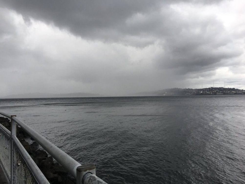
Just south of Alki Point, it’s prime wave-watching, even with high tide still 2+ hours away. (video added)
11:56 AM: More road reports – Signal out at Myers/Olson (the City Light map shows a small outage there) … tree down on eastbound Admiral Way in Alki area (WSB photo added) …

Tree on eastbound Orchard east of Delridge, photo courtesy @SabaGebru:

12:08 PM: Outage mostly south of West Seattle, 4,300+ customers – here’s a screengrab from the SCL map:

12:44 PM: Tree trouble in Arbor Heights, near 37th/108th – thanks for sending the photo:

Close call, they report: “We’re fortunate it didn’t hit anyone AND it landed right in between the two cars.”
1:44 PM: The aforementioned outage remains the only one of note anywhere near us, and some of those customers have their power back – it’s now a 3,400+-customer outage. The NWS, meantime, says the wind will peak in the next few hours. Certainly a storm of many faces – we’re in The Junction right now and the sun has even made an appearance.

2:47 PM: The photo above shows chunks of driftwood on the road alongside Constellation Park after the high tide earlier this hour sent those windwhipped waves even further over the road. Along the quiet north-facing side of Alki, just a bit of slopover:
Alki is getting pretty soggy in this afternoon's windstorm. @westseattleblog @KING5Seattle pic.twitter.com/KyEcYzgwaU
— Podcast West Seattle (@podcastwseattle) December 20, 2018
We’ve been through The Junction, Delridge, points inbetween, and it’s relatively placid. The outage to the south of WS is now down to 1700+ customers.
3:15 PM: The NWS’s afternoon Forecast Discussion confirms it’s “settling down,” so we’re going to move on to some other news. We’ll update this story as warranted, of course, or launch something new if any major incidents are reported.
4:45 PM: All’s still relatively well. The outage to the south is now down to 110 customers; there’s a few scattered one-customer outages mapped for West Seattle, and a group of 9 south of Westcrest Park, otherwise things have stayed stable on the power front.
FIRST REPORT, 7:24 AM: The National Weather Service has issued a weather alert for 7 am-7 pm Thursday, a High Wind Watch, warning of winds possibly as strong as those that hit last Friday night and cut power to thousands:
* WIND…South to southeast wind 25 to 40 mph with gusts up to 60 mph. Strongest winds will be near the shoreline.
* TIMING…Winds will increase rapidly early Thursday and continue through the evening.
* IMPACTS…Snapped tree branches and downed trees along with local power outages.
Read the full alert here.
10:59 AM: Now upgraded to a High Wind Warning.
 (Find the City Light “live” outage map here)
8:09 AM: As noted earlier, though the windstorm is long over, new outages have hit this morning, in High Point and toward the east end of the Roxbury corridor. We’ll be covering those in the hours ahead, and checking out windstorm damage/cleanup around the area. Thanks for all the tips and updates in our past 14+ hours of coverage – more to come!
8:24 AM: That end-of-Roxbury pocket, and the North Highline outage area it was part of, is back on. The SCL map shows a few hundred, mostly in North Delridge/Puget Ridge/Highland Park, still out since last night.
9:27 AM: Anyone on the water missing this?

Karen sent the photo and says it’s beached in Lincoln Park.
10:52 AM: We’ve been out for an hour looking for aftermath such as downed trees. Thanks to a tip, finally found one:

That tree has SW Orchard closed just north of Dumar.
12:22 PM: Oregon is blocked between 38th and 39th because of this:

Police say the house’s residents heard it crack during the wind. They have evacuated. City Light has been called.
1:18 PM: The SCL outage map now shows only scattered, single-customer outages in our area. If you’re out and the map doesn’t show it, be sure SCL knows – 206-684-3000. Their map shows 2,500 still out, service-area-wide.
2:42 PM: Another storm-related closure, tweeted by Seattle Parks:
Southwest Pool is closed the rest of today (Saturday, Dec. 15) and tomorrow (Sunday, Dec. 16) due to problems with the boiler following yesterday’s power outage. Please call the pool or check here for updates.
— Seattle Parks (@SeattleParks) December 15, 2018
(FOR NEW SATURDAY REPORT, GO HERE)
ORIGINAL REPORT, 5:35 PM: If you haven’t been outside lately – or are getting ready to head home from work – the wind has arrived. As noted earlier, the National Weather Service downgraded the alert early this morning but still warned that gusts could get into the 40s; this is supposed to ease within a few hours. We’ll be tracking the storm in the meantime. No outages or other notable effects reported in West Seattle right now but if you see/hear about something, please let us know – text/voice 206-293-6302 – thank you.
5:38 PM: And minutes later … our power went out. Yours?

5:46 PM: More than 6,700 homes/businesses, as shown on SCL map. Also, a tree is reported down in the 2700 block of 51st SW. Also, another one in an alley in the 8800 block of 24th SW.
5:58 PM: As noted in our daily preview, MANY activities were scheduled tonight, so if anybody has official word of cancellations/changes, please let us know. We are headed out to check on some locations, such as the Sealth/Denny campus. Also, a revised total: The SCL map has this grouped as two outages, one with 6,740 customers affected, one with 957, so almost 7,700 homes/businesses.
6:07 PM: The West Seattle Community Orchestras concert that was scheduled for 7 pm at Chief Sealth IHS is postponed.
6:16 PM: For those asking about an estimated restoration time – the map currently just says “December 15” (tomorrow). But as we’ve noted in coverage of many outages (first one we covered was exactly 12 years ago tonight – the Hanukkah Eve windstorm), the estimates are relatively useless, could be much sooner, or much later. In this case, given the growing number of outages around the city, plan for later. Keep your fridge closed.
 (Texted photo – downed trees/limbs in Eddy St. ravine)
6:21 PM: Trees reported down in 5200 block 23rd SW and near 24th/Henderson, also trouble at 10th/Henderson.

One event that is STILL ON – Denny IMS Winter Party (Posada) – they have generator power. (photo above). … More from scanner: Stop sign blown down at 63rd/Admiral. … Per comment: Chief Sealth/Garfield basketball is canceled. … WESTWOOD VILLAGE: We went over to check – Target/Barnes&Noble side is on, center stores on, QFC out and stores north of it – to Marshall’s – are out.
6:53 PM: Now the outage map includes an area south to Roxbury that adds 2,273 to the previous West Seattle total, so that means almost 10,000 customers out in West Seattle. From comments: Cocoa For a Cause, a Brownie troop’s project at West Seattle Lights, is postponed. … Also: Art Lounge at Highland Park Improvement Club is canceled. Meantime, a party that went on as scheduled:

West Seattle Be Prepared and the WS Amateur Radio Club were having their combined holiday party when the outage hit. Reports Jim Edwards, who sent the photo: “Between solar, generator and battery powered jug lanterns we are enjoying all that this season has to offer.” … Tree reported down near 18th/Orchard … Our crew says 24th SW is blocked at Henderson/Barton, with crews working on the reported downed tree there.
7:33 PM: Multiple commenters confirm what the map shows – Junction (and points north) NOT affected, so if you are looking for dinner, etc., head there. Lafayette Elementary‘s new Festival of Lights still on, too – thanks to Max for the photos:

Tomorrow too, so if you missed tonight/didn’t want to go out in the wind, you’ll have another chance. Twelfth Night Productions’ “A Christmas Carol” at Kenyon Hall, still on tonight, too, per Lou Magor‘s note (Saturday and Sunday shows remain as well) … (Photo added – “Christmas Carol” by lantern – thanks to Anna for the pic:)

Still no new info on restoration and not likely to be, as SCL now has almost 45,000 out around the region. … We found an SDOT tree crew working at 26th/Barton in Westwood:

Be on the lookout for lost pets (here’s our lost/found pets page) – we’ve already had two lost dogs reported tonight (and reunite one) – e-mail info to westseattleblog@gmail.com or text 206-293-6302.
8:30 PM: As noted in comments, the Morgan Junction business district has power. We are headed north on California and on that arterial, the outage is from just south of Mills, southward. … Alaska, Admiral Junction all on … so is Alki.
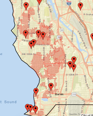
9:07 PM: The National Weather Service extended the Wind Advisory until 10 pm. In general, the wind in our area is indeed calming – the 9 pm gusts are lower than the 8 pm gusts. For a commenter who asked, here’s a grab of the West Seattle-and-southward outage map as of a short time ago:
9:42 PM: Though the West Seattle outages don’t appear to have changed in size, the total number out throughout SCL’s service area is now 43,000+, down about 3,000 from the peak. Meantime, since we are now into the fifth hour, you might be interested in food-safety advice regarding what’s in your fridge, if you are in the outage zone.
10:15 PM: Getting reports of restoration in the High Point area.
10:30 PM: The map now reflects more than 1,300 West Seattle customers got power restored.
11:44 PM: Seventh hour without power for 8,000+ in WS. Throughout SCL’s area, 36,000+ are now mapped as out, down 10,000 from the peak. Meantime, we’ve heard about another downed tree, this one at Jacobsen and Hudson, via Alyson, who says it’s not blocking the road but appears to have brought down a cable wire.
12:54 AM: 8th/Elmgrove report of restoration via a comment. West Seattle outage is ~300 customers smaller in latest map update. Meantime, a fire alarm brought SFD to Bed Bath Beyond in Westwood, but no fire – they think the alarm was outage-related and are closing the response.
1:07 AM: Our power just came back on, after 7 1/2 hours. Hearing from others too.
1:28 AM: We’ve noted before that SCL’s new map lags more than its predecessor. Noting that now – we’ve been back on for more than 20 minutes but we’re still shown as out. So we don’t know yet how many got power back in that last wave. The map shows 30,000 still out, service-area-wide.
6:29 AM: Thanks for the updates. Looks like the outage is down to a few hundred in West Seattle, still 11,000+ out in SCL’s service area – almost half of them south of here. (added) Here’s a screen grab of the last West Seattle pockets:

We’re working on the daily highlight list right now – assuming everything’s on as scheduled but let us know at westseattleblog@gmail.com if not – then once it’s light, we’ll be looking around for storm damage – please also let us know if you’re dealing with anything (downed trees, etc.) – thank you!
7:43 AM: A few reports of power going out again in part of High Point a few minutes ago. Ours in Upper Fauntleroy flickered.
7:59 AM: Launching a new report on current outages and aftermath. (added) Find it here.
12:57 PM: Though the last wind alert didn’t pan out, the National Weather Service has announced a new one – we’re under a High Wind Watch for 10 am-6 pm Friday, possible gusts to 60 mph out of the south. See the alert here.
7:02 AM FRIDAY: The alert is now lower-level – a Wind Advisory, in effect 1-7 pm, with south wind, possibly gusting to 45 mph.

2:39 PM: Seen in West Seattle this morning … a snowplow. No snow in the forecast, but it’s a reminder that winter is just days away – the solstice moment is 2:23 pm our time on Friday, December 21st. We also have another sign of impending winter – this announcement from Seattle Parks:
Routine winter preparation has begun with most Seattle Parks and Recreation comfort stations and drinking fountains closing for the winter season to prevent pipes from freezing. We expect to complete winterizing and closing impacted facilities by the end of the month. We will begin reopening comfort stations and water fountains in March 2019.
3:12 PM: While we’re talking weather, the National Weather Service has just announced a wind alert for our area – we’re in “wind advisory” mode until noon tomorrow (Thursday). Things will start picking up this evening and gusts could hit 50 mph, the NWS says.
ADDED 7:29 AM THURSDAY: The wind never did show up – in this area – and the advisory was canceled overnight.

Thanks to Chris Frankovich for the photo of tonight’s spectacular sunset. This gives us the opportunity to note that a chilly week is expected – lows could get into the 20s starting tonight, and highs are expected to be in the low to mid-40s.

Thanks to Chris Frankovich for the early-morning view of the Olympics, finally showing some snow. In our area, a stormy Monday is forecast – windy and rainy, especially in the afternoon and evening, with gusts, out of the south, up to 40 mph possible.
Minutes ago, the National Weather Service issued a “dense fog advisory” alert for our area. It’s in effect until noon. The NWS warns, “Dense fog will result in poor driving conditions for the entire morning commute. Patchy areas of freezing fog may also lead to isolated areas of black ice on bridges and some roadways.” Read the alert in its entirety here.
We’re on wind watch with the advisory continuing until 4 am; the forecast currently says the gustiest wind is expected after midnight. We’ll be updating with anything of note we hear about, starting with:
11:43 PM, UTILITY POLE DOWN: Don’t know whether it’s weather-related, but a texter reports that a pole and wire are down on 34th SW between Myrtle and Othello and that police are on scene.
1 AM UPDATE: Breezy but nothing dramatic. The Alki Point reading (K91S on this list) is 21 mph at the top of the hour. A little dicey on the roads, though, with crashes this past hour on the westbound West Seattle Bridge and at Admiral Way/39th SW.
1 AM, THE SECOND TIME AROUND: Welcome to Standard Time! Alki Point’s at 22 mph now.
3 AM: Same velocity. Overall, things have been relatively quiet. From indoors, we’ve been hearing the rain more than the wind.
TIPS/INFO? Text/voice 206-293-6302 any time.

10:50 AM: We mentioned on Friday that gusty wind was on the way. Now there’s an official “wind advisory” for 8 pm tonight through 4 pm tomorrow, according to the National Weather Service (tan area on the map above):
* WIND…Southerly winds increasing to 20 to 35 mph with gusts to 45 mph.
* TIMING…Winds increasing early this evening and continuing into the early morning hours on Sunday. Winds easing around 4 am Sunday morning.
* IMPACTS…Isolated power outages possible. Plenty of leaves left on the trees could get blown off tonight. This combined with the rain could result in some clogged storm drains producing minor flooding on area roads.
If you can, today is also a good time to clean up the leaves that already have come down – if you have residential yard-waste pickup, you can set out extra containers for free this month.
3:15 PM: The advisory‘s been revised a bit – we could see gusts up to 50 mph, the NWS now says.

Thanks to Jim Borrow for the rainbow view from Alki! Before we get to the news and events – a forecast reminder: The wind could gust up to 30 mph this afternoon, 35 mph tomorrow night and Sunday, and with some leaves still on the trees, that’s still enough to possibly cause trouble this time of year. As always, if there’s weather trouble – outage, downed tree, etc. – wherever you are, once you’ve notified authorities, please let us know too! 206-293-6302 is our text/voice hotline, 24/7.

Thanks to Monica Zaborac for the photo from Constellation Park south of Alki Point! If you’re a wave-watcher, things are wet and wild there right about now, with an 11.4-foot high tide at 12:58 pm and winds from the south to southwest. Gusts could get up to 35 mph later today, according to the forecast, maybe 40 mph tomorrow, so even though that’s not quite warning level, it’s a good idea to keep things charged, just in case.

(WSB file photo)
As the leaves continue falling off trees, a fall rainstorm is on the way – more than an inch expected!- so it’s time (as @WestSeaWX reminded us via Twitter earlier today) to check your nearest storm drain(s). Clear away leaves and other debris if needed. P.S. If you have lots of leaves to clear in the days and weeks ahead, and you are a household pickup customer with Seattle Public Utilities, you’ll be able to put out up to 10 extra bags of yard waste in November at no extra charge.

Thanks for the photos from above the fog! Top pic is by Eugene Lee, looking west from Gatewood, near Myrtle Reservoir Park. Below, by Susanna Moore, looking northeast toward downtown:

And from Twitter:
Haven't seen this in our three years here. @westseattleblog @KSeattleWeather pic.twitter.com/iXfXpFPwFa
— Ethan Owens (@Twixted1) October 20, 2018
That fog today 🦄 pic.twitter.com/dvqk3w0Gbc
— Dené Miles (@DeneMiles) October 20, 2018
And one more sunset view e-mailed to us, from Gatewood, by Stephen Sills:

Forecast says we might have “areas of fog” tomorrow morning too.

Look what’s back – mountain snow! Lynn Hall photographed the morning glow on The Brothers early today. The National Weather Service notes that Friday was relatively cold down here at sea level, too – in more than 120 years of recordkeeping, Friday’s high of 53 degrees was the lowest October 5th high ever recorded. (The old record was 54 degrees on October 5, 2007.)

Thanks to everyone who sent photos of tonight’s beautiful beginning! Above, from Philip Cox; below, from Jim Borrow:

And from James Bratsanos:

The predicted wind is not at an alert/warning level, but the National Weather Service wants you to be aware that tomorrow could be “breezy” enough to bring down some tree branches, which ups the risk of power outages. The predicted speed, with the wind switching from south to north, will be 15 to 25 mph, possibly gusting to 35 mph. You know the advice: Charge everything, just in case! (Thanks to @WestSeaWx for the tip.)

Thanks for the photos, just texted from Admiral (above) and Alki (below).

Summer officially ends at the autumn-equinox moment Saturday at 6:54 pm. The forecast suggests its arrival might be a bit blustery!

Thanks to Dan Ciske for capturing the smoky sunset from Upper Alki. After a brief return of unhealthy-for-some air quality – blamed largely on a fire near Mount Rainier – it’s supposed to be improving right now.

8:42 PM: Tonight’s pink setting sun was a reminder there’s still smoke in the area – while not enough to hamper cross-Sound visibility, the Olympics were mostly out of view. The Washington Smoke Information website says you can blame BC fires for that, and the Puget Sound Clean Air Agency adds:
We may see some smoke from the Vancouver Island fires Wednesday morning, which could cause levels to briefly reach MODERATE or UNHEALTHY FOR SENSITIVE GROUPS. Rain and clouds are expected to follow that evening and into Thursday which should keep our long-term AQ in the GOOD to MODERATE through Friday.
ADDED: Thanks to Tiff Rivera for these views of the sunset and moonrise:


| 1 COMMENT