West Seattle, Washington
21 Saturday

One week after the shutdown of the 4th Avenue offramp from the westbound Spokane Street Viaduct section of the West Seattle Bridge, you can see crews wasted no time in taking it down. Marybeth Turner of SDOT visited the construction site on Thursday and shared this photo with us today. The north side of the westbound SSV is where the widening will take place, with a brand-new structure added; the new westbound off/on-ramp will be at 1st Avenue, while a 4th Avenue offramp is being built on the eastbound side. This gives us a reason to remind you that as of minutes from now, the northbound I-5 ramp and Columbian Way ramp to the westbound West Seattle Bridge are both closing for what could be the entire weekend, till Monday morning, though the same shutdown pattern last weekend ended much earlier than planned (on Saturday night); we’ll keep you up to date on changes. The city’s infopages on the project start here; more photos of the ramp demolition are here; our archives of project coverage, dating back more than a year and a half, start here.
 In that photo we took 17 months ago, King County Executive Dow Constantine stood next to the man who held the title at the time, Ron Sims, as the county announced money from the state would pay for more bus trips during Alaskan Way Viaduct-related construction. With that construction really revving up, more of those added trips are kicking in. Today – thanks to Robert for noticing and sharing the details — we know more about new Metro trips to/from West Seattle taking effect at the next “service change,” one week from tomorrow (February 6). (You can get the full list by going here and clicking Metro Schedule and Route Revisions.) West Seattle highlights include:
*21E – Northbound service to downtown Seattle will have three new trips arriving at 3rd Ave & Pike St about 7:50, 8:14 and 9:17 am. Southbound service to Arbor Heights will also have three new trips leaving 1st Ave & Union St about 4:25, 4:55 and 5:25 pm.
*54 – Service will improve to every 10 to 15 minutes during weekday peak periods.
*56E – Northbound service to downtown Seattle will have two new trips arriving at 3rd Ave & Pine St at about 7:45 and 8:14 am. Southbound service to Alki will also have two new trips leaving 1st Ave & Pike St about 5:13 and 6:09 pm.
*60 (White Center)- Service will improve to every 15 to 20 minutes between 6:30 am and 6 pm weekdays. Northbound trips will leave from a new bus stop northbound on 15th Ave SW & SW 100th St. Two new southbound trips will leave 10th Ave E & E Mercer St at 10:10 and 11:10 pm. Route 60 will also be revised to serve the Olson Pl/Meyers Way P&R on weekdays.
11:34 AM UPDATE – The South Park Bridge closures are POSTPONED till a future date.
One more reminder about three closures this weekend that might affect your travels to and from West Seattle:
10 PM TONIGHT THROUGH 5 AM MONDAY: That’s the schedule again this weekend for closures of the northbound I-5 ramp and the westbound Columbian Way ramp to the West Seattle Bridge, both related to the Spokane Street Viaduct Widening Project. (Last weekend the work finished fast and both reopened Saturday night.) Details here.
7 AM-7 PM DAILY, SATURDAY THROUGH TUESDAY: The South Park Bridge will be closed to vehicle traffic, and will not open for marine traffic, all four days. Crews plan to do tests related to future construction of a replacement bridge; details here.
From the Alaskan Way Viaduct/Seawall Replacement Project South Working Group meeting Wednesday:
 No bombshells; group members – including Jerome Cohen, Vlad Oustimovitch and Pete Spalding from West Seattle – were shown long lists of numbers regarding travel-time and traffic-flow projections, depending on scenarios including toll or no toll, vs. tunnel toll or tunnel-plus-other stretch(es) toll. (“Meeting materials” are linked here.)
Two of the scenarios looked at the possibility of tolling the stretch of 99 between the future tunnel’s entrance and the West Seattle Bridge, and Oustimovitch expressed concern about that in end-of-meeting around-the-table Q/A, but after the meeting, WSDOT’s Ron Paananen clarified to WSB that the extra stretch is NOT being seriously considered. “We looked at (tolling beyond the tunnel), recognizing that diversion (of traffic seeking toll-free routes) would be an issue, to see if (tolling) would change diversion patterns. It had a modest effect … people diverted further upstream. So if you’re worried about diversion, (expanding the tolling) is not a great strategy.” It brought in more money, of course, he noted, but he said that it appeared they would get the $400 million they need by tolling the tunnel. Summarizing, he said, “I think we answered the question that funding this project most likely will occur through tolling of the tunnel only.” If the tunnel is tolled, it is currently expected to start in early 2016, would be collected electronically, and could range from $1 to $5 in “2015 dollars.” Other toplines from the meeting (plus an explanation of the graphic above left, added Friday morning) – read on:Read More

From WSB photojournalist Christopher Boffoli: SDOT crews are putting up 2-hour signs along a stretch of 41st SW this afternoon – part of the Junction parking plan recently finalized, almost two years after first word of the city review. (You’ll recall, the review resulted in a decision for NO pay stations, and NO “restricted parking zones” – just some new 2-hour-zone signage; see the map in our most recent story.) ADDED 6:26 PM: In e-mail this evening, SDOT project manager Dante Taylor confirms the sign installation and included a reminder that there will be a meeting later this year open to anyone who wants to hear and talk about how the changes are working.
From King County:
The King County Road Service Division will close the South Park Bridge spanning the Duwamish River to both vehicle and marine traffic from 7 a.m. – 7 p.m. daily Saturday Jan. 30 through Tuesday, Feb. 2. The four-day closure will allow engineers to perform noise and water quality testing and simulate vibration that might occur during bridge construction. During the closure, engineers will conduct pile driving to measure noise, vibration and take water quality samples. Data collected during the tests will assist the county in planning for construction of a new bridge when financing becomes available. During the closure, motorists can detour via the First Avenue South Bridge.
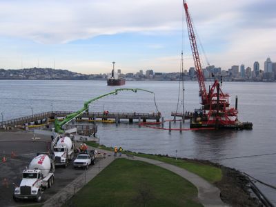
Thanks to WSB’er “kmo39” – who has shared updates before on the progress of the King County Water Taxi dock project at Seacrest – for sharing that photo taken this morning: Now that the pilings for the new dock are in, concrete pouring is under way. The Water Taxi is scheduled to start running again in April, and if funding is finalized over the summer, its year-round operations could start this fall; the dock project is a prelude to that, since the previous wooden floating dock – shaky even in summertime – didn’t suit rough-weather operations. Also a reminder – the King County Ferry District board (King County Council members) is scheduled to take up the new proposed fare structure (including a 50-cent increase if you pay cash) on Monday (1:30 pm, County Courthouse), with a public hearing – here’s our story from last week.
That map just sent around by Delridge Neighborhoods District Coordinator Ron Angeles; it expands on the map published here last night when SDOT sent out its latest news release about the upcoming construction-related closures on and around the Spokane Street Viaduct (aka the section of West Seattle Bridge between 99 and I-5). As you can see, this one includes some other closures right outside the general area covered by the original map/info. This expanded list can be found on the city website here – along with a larger, more readable version of the map. Most immediately, as mentioned last night, tomorrow’s the day that the 4th Avenue S. exit from the westbound SSV closes forever, and a longer stretch of lower westbound Spokane Street closes too; plus the West Seattle Bridge ramps from northbound I-5 and Columbian Way on Beacon Hill both will close for the entire weekend, 10 pm tomorrow through 5 am Monday.
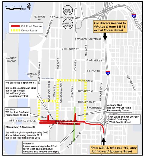
We’ve been reporting on this for more than a year and a half, and now it’s about to intensify – day after tomorrow, a ramp and road closure kick in for the Spokane Street Viaduct Widening Project. The city’s sent out a reminder tonight as well as the detour map above – read on for the news release:Read More
Reminder of the road closure reported here last night – SDOT plans to work most of the day at the scene of last week’s slide in the 6000 block of Beach Drive (map), and will close the road there till approximately 4 pm, with a detour planned to its south, Atlas to 49th to Canada (map).
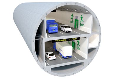 Some new info out today from the Alaskan Way Viaduct project team. They’re out with a new report about the tunnel project’s projected cost, as well as potential tolls. The report is here; among the highlights, they say they’d charge different tolls for different times of day, potentially $3.50 during peak commute hours. Read on for the news release with toplines; the report’s also been summarized by our partners at the Seattle Times. (One of its points, the new alignment for the tunnel’s south end, was reported during the South Portal Working Group meeting covered here last month.)Read More

Tomorrow’s the day for a new round of closure/changes because of the East Marginal Way Grade Separation, the latest in the big line of road projects affecting people driving between West Seattle and points east/north. Here’s the advisory from the city’s SODO Traffic list:
East Marginal Way Grade Separation Construction begins tomorrow, Thursday, Jan. 14
When complete, the new overpass will decrease traffic delays, improve business access and increase safety. The new structure will be in service by mid-2011.
· The right-hand east bound lane of S Spokane St between E Marginal Way and Duwamish Way will be closed from 7 a.m. to 4 p.m. January 14, 15 and 18.
* All lanes on S Spokane St will be open between 4 p.m. and 7 a.m.
* The permanent closure of the northbound lane of Duwamish Way begins January 14.
* Both lanes of Duwamish Way will be closed for the duration of the project beginning February 1.
11:54 AM: That’s video of work being done at the slope with the slide that shut down Beach Drive in the 6000 block – south of there, it’s closed to the Lowman Beach intersection (as first reported here very early this morning), since there are no outlets. SDOT told us at the scene at midmorning that they needed to evaluate the stability of the top of the slope before figuring out what needed to be done to stabilize it, and how soon the road could be reopened. Note that Route 37 buses are being detoured TFN. We’re continuing to check with SDOT for the latest and will add updates as we get them. 2:02 PM UPDATE: Just checked the scene. Road’s still closed, and as some have noted, the tricky thing is that there is no signage at Jacobson, which is the last place to head east/uphill before the closure – so we’re seeing many people drive all the way up to the closure, be surprised, and turn around to head back. Here’s the latest from Marybeth Turner at SDOT:
The urban forestry crews expect to wrap up, and then we will clean up and set up traffic control to reopen Beach Drive, except for restriction to one lane at slide site. Goal is to reopen by 5 pm. We will continue to monitor the site through the weekend.
5:29 PM UPDATE: The road’s open again, per the Metro alert that says 37 and 53 are back on their regular routes.

(WSB photo added 10:12 am)
ORIGINAL 2:28 AM REPORT: Thanks to Leslie (via e-mail) and Susan (via Facebook) for sending word of a road closure on Beach Drive. We checked with Southwest Precinct Lt. Ron Smith, who confirms that “SDOT responded to a landslide in the 6000 block of Beach Drive (map) … SDOT determined the landslide posed a risk to the public and closed the street.” He says that right now, there’s “no time frame for reopening the street.” We plan to check on its status before morning commute. 7:38 AM UPDATE: Still closed, per SDOT’s Rick Sheridan:
The road in the vicinity of 6031 Beach Drive SW was closed late last night due to a landslide risk. Concerns about a tree sliding onto the road due to wet soil conditions caused the city to close the roadway area for safety reasons. Metro has been notified and will reroute their buses based on this closure. We will reevaluate the area once we have daylight to determine how to stabilize the area and reopen the roadway.
As noted in comments (also thanks to Robert for the e-mail tip), Route 37 buses are rerouted because of the closure. Metro’s e-mail alert says:
Route 37 inbound service is temporarily rerouted this morning due to a mudslide at 48th Av SW & Beach Dr SW. Please use stops on 49th Av SW north of SW Hudson St or on Beach Dr SW north of SW Jacobson Rd.
You can sign up for route-specific alerts by starting with the box in the right sidebar here.
9:48 AM: We’re at the scene and will post a separate update soon with video/pix. Still no ETA for reopening the road – SDOT still has to evaluate the stability of the top of the slope. It’s closed from the 6000 block on the north to the Lowman Beach intersection on the south.

Story and photo by Christopher Boffoli
Reporting for West Seattle Blog
At Tuesday night’s Junction Neighborhood Organization meeting: Information from SDOT on the implementation of the West Seattle Junction on-street parking changes (as well as discussion of some wider transportation issues), updates on the status of Junction Plaza Park, and a plug for West Seattleites to attend upcoming Southwest District Council meetings.
The meeting began with a presentation by Danté Taylor, Associate Transportation Planner for SDOT, who gave a brief review of the Junction parking study completed last year.
Read More
 If the King County Ferry District Board – aka King County Council – says yes, the KC Water Taxi‘s West Seattle run will charge 50 cents more for adult passengers who pay cash, starting this spring. A new fare schedule is up for a public hearing when the board meets January 25th – including Seattle-Vashon Water Taxi fares:

Reasons cited for the rate increase – which would be the first in three-plus years – include wanting to encourage transit-pass use. The meeting on January 25 is at 1:30 pm in County Council chambers at the County Courthouse downtown; you can read related documents by following links from this page on the Ferry District website. Next Water Taxi season is scheduled to start April 4; work is under way at Seacrest right now to improve its dock in hopes of year-round operation, which will require additional funding that the county’s hoping will be worked out this summer. P.S. We just asked spokesperson Kris Faucett if there’s been a decision on which boat the county will lease for the new season (since Argosy is no longer running the service) – she says there should be news about that “soon.”
Announcement this afternoon from WSDOT – regarding some of the work you may be seeing along 99 and The Bridge (the city’s working on part of this system too) – read on:Read More
Just in from the mayor’s office – a city official from Renton is coming to work in Seattle as the successor to Department of Transportation director Grace Crunican, who announced her resignation nine days ago – read on for the announcement:Read More
SDOT just sent this traffic alert: “Seattle Public Utilities (SPU) crews will use closed circuit camera equipment to survey a sewer line on Battery Street above the Battery Street Tunnel this Sunday, January 3, from 2 a.m. to 8 a.m. This work requires closing the northbound lanes of the Battery Street Tunnel during this time.”
Drive to or through SODO? You’ll be interested in the traffic alert we just received from WSDOT – it’ll affect city streets as well as state routes. Read on:Read More
Heading out of West Seattle for a story-related interview yesterday, we noticed a sizable crew working by Walking On Logs; Anne at WSB sponsor Ventana Construction noticed too, including the detail that they appeared to be pouring concrete, and wondered what’s up. We checked with SDOT to see what project this is related to, and Marybeth Turner replied today that this is more work related to one of West Seattle’s new traffic cameras: “SDOT crews are pouring the foundation for a new pole on which the traffic camera will be mounted and also pouring the foundation for a new control cabinet. You will likely be seeing crews out during the next month or two completing the work at this location–installing a pole and mast arm, installing the cabinet, etc. The new ‘ITS’ items being installed at various locations in the city will not be operational until the fiber optics system that connects all of them is completed.” As reported here last month, the new traffic cameras – which are also going up in The Junction and near the Fauntleroy ferry dock – aren’t scheduled for activation before March. (ITS is the “Intelligent Transportation System,” explained by SDOT in this WSB story from March, in which we had first word of the new traffic cameras.)

In the comment section following yesterday’s update on impending King County Water Taxi dock construction at Seacrest, there was a request for a closer look at the plan, to find out more about how divers might be affected. We asked the King County Department of Transportation for an image of the latest rendering – all we had was our photo of what was up on an easel at a meeting early last year – and what you see above is what they sent today. (Click the image, or here, for a larger view – you may have to click “zoom” if your browser allows it, once the new image comes up.) Most of the components are being built off-site to minimize the amount of time people are affected at Seacrest, but piles will be driven and so neighbors are warned of noise and other construction-related inconveniences. The first day of this year’s Water Taxi season is scheduled to be April 4, but whether it continues year-round from that point on – as the new dock is meant to facilitate – depends on the results of a search for funding, since the county budget crisis last fall led to the King County Ferry District cutting back on the taxing authority it was using.

That’s the finalized map from SDOT showing the end result of the two-year West Seattle Junction parking review, posted online yesterday and mailed to Junction-area businesses and homes. (Click the image or here to see the mailer full-size.) The review began in February 2008 (here’s our first report), elicited mostly sighs of relief five months ago when SDOT announced no pay stations were forthcoming, then ended in November (WSB coverage here) with a recommendation of signage changes along several blocks in the “study area.” They’re the same ones announced at the November meeting – on the map above, the ones marked in green will be posted as 2-hour zones, and the ones marked in dark blue will change from 1-hour to 2-hour zones, with the signs going up “in early 2010.” Here’s the official city infopage for the Junction parking review – that’s where you can read the background documents including evaluations of the Junction parking situation as surveyed during the review. Also worth noting if you missed our November report – though the city’s original plan was to study another West Seattle neighborhood’s parking situation in 2010, SDOT said that plan’s now changed, and there won’t be another survey here (Admiral, Alki and Morgan Junction are on deck, eventually) before 2011.
| 5 COMMENTS