Reminder: Spokane Street Viaduct Project closures ahead

We’ve been reporting on this for more than a year and a half, and now it’s about to intensify – day after tomorrow, a ramp and road closure kick in for the Spokane Street Viaduct Widening Project. The city’s sent out a reminder tonight as well as the detour map above – read on for the news release:

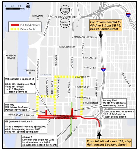
Work by the Seattle Department of Transportation (SDOT) to widen the South Spokane Street Viaduct – the 60-year-old elevated roadway that connects I-5 to the West Seattle Bridge – will have additional traffic impacts beginning Friday, January 22. SDOT’s contractor, PCL Construction Services, will begin construction near Fourth Ave S and S Spokane St that will necessitate the following ramp and lane closures (subject to change due to unforeseen circumstances):

* Permanently close the existing westbound Spokane Street Viaduct off-ramp to Fourth Ave S beginning Friday, January 22, at 10:00 p.m.

* Close the northbound I-5 off-ramp leading to the West Seattle Bridge for the weekend (10:00 p.m., Friday, January 22 through 5:00 a.m., Monday, January 25).

* Close the ramp from westbound Columbian Way leading to the West Seattle Bridge for the weekend (10:00 p.m., Friday, January 22 through 5:00 a.m., Monday, January 25).

* Close all lanes of westbound lower Spokane Street (from Sixth Ave S to First Ave S) to through traffic for the duration of the project beginning January 22. Local business access, however, will be preserved throughout the duration of the project.

* Close Fourth Ave S between S Horton and Industrial Way S to all traffic from 10:00 p.m., Friday, January 22 to 5:00 a.m., Saturday, January 23. Possible further restrictions as needed.

* Reduce Fourth Ave S between S Horton and Industrial Way S to one lane in each direction beginning January 22, and lasting for a minimum of one month. This may include full closure of northbound lanes at night for up to a week.

Due to the closure of westbound lower Spokane St and the westbound Fourth Avenue S off-ramp, traffic will be detoured on surface streets through the south of downtown area via the detour route shown on the enclosed map (see attachment). Drivers should expect congestion on I-5 near the Spokane Street Viaduct and in the SODO area Friday night through early Monday morning. This phase of the project should have minimal disruptions for King County Metro Transit bus service, but there could be delays if there is traffic congestion. In case of rain, crews will reschedule this weather-dependent work for the following weekend.

SDOT has several tools to help motorists get around during construction, which are outlined below:

* Detour maps/E-mail updates – Visit the SDOT project Web site for detour routes and maps, and to sign up for e-mail updates about the project:
www.seattle.gov/transportation/spokanestreet.htm

* Travelers Information Map – Visit this SDOT Web page to better plan your
driving route: http://web5.seattle.gov/travelers/

* Way To Go SoDo – Get information on alternative transportation at this
SDOT Web site: http://www.seattle.gov/waytogo/wtg_sodo.htm

When complete, the South Spokane Street Viaduct Widening project will nearly double
the width of the elevated roadway. Seattle commuters and the freight community will
enjoy improved access between I-5, SODO (the area south of downtown) and West
Seattle, and significantly improved traffic flow and safety on this key east-west
route. The $168 million viaduct effort, SDOT’s largest project currently in
construction, is expected to be complete by 2012.

22 Replies to "Reminder: Spokane Street Viaduct Project closures ahead"

  • 4thGenWestSide January 20, 2010 (6:53 pm)

    Can you say cluster f@€k?

  • RobertSeattle January 20, 2010 (7:02 pm)

    Every time I see the Lander Detour I can’t help but think that lots of WS’ers will be using the Horton (that road at Burger King) as “our” shortcut. Is the city doing something to prevent that?

  • JanS January 20, 2010 (8:40 pm)

    well, they haven’t made going over the train tracks any better on Horton…that would deter me – lol. Used to have to pick the Ex up after work down there – ugh ! All this makes me so glad I work at home !

  • Melissa January 20, 2010 (9:31 pm)

    I don’t get it. The statement above says, “Seattle commuters and the freight community will enjoy improved access between I-5, SODO (the area south of downtown) and West
    Seattle, and significantly improved traffic flow and safety on this key east-west
    route.”

    But how does this improve our access to Sodo when we can’t get back home from Sodo or downtown except by taking the low bridge?

    And I really would love if someone could give me some sort of a response. I just dont’ get this.

    • WSB January 20, 2010 (9:54 pm)

      I am pretty sure they are talking about what it will be like when the whole thing is done. They will have a new ramp accessing 1st, and the new offramp at 4th (call it the Costco shortcut) off the east side.

  • Melissa January 20, 2010 (9:33 pm)

    And that was supposed to be “don’t,” but the edit function wouldn’t let me fix it.

  • West Seattle Sun January 20, 2010 (11:11 pm)

    Melissa,

    This may help clarify the project and settle your perfectionist tendencies?
    http://www.seattle.gov/transportation/images/SpokaneViaductProjectArea.jpg

    I hope you “get it” now?

    Let’s all plan our commutes around the project and leave early or don’t leave at all!

  • Carole January 20, 2010 (11:26 pm)

    Can anyone provide advice on getting to and from Costco during this mess?

  • celeste17 January 21, 2010 (2:12 am)

    Carole, I would take the first ave bridge during all of this mess and use the michigan street exit to get to Costco (take a left on 4th Ave after getting off the bridge). And coming home take the bridge and get off at the first exit, take a right at the end of the exit and then continue onto West Marginal and then hook up with Avalon or Admiral under the bridge.

  • JayDee January 21, 2010 (6:20 am)

    Carole: Oddly enough to get to Costco now I find it easier to take I5 south to Michigan exit, and then backtrack west to 4th, then north and come into Costco from the south. Longer but seemingly faster.

  • Bettytheyeti January 21, 2010 (7:13 am)

    Thanks on the Costco re-routes I wondered how?

  • Carole January 21, 2010 (7:39 am)

    Thanks for the route advice! Suddenly Costco doesn’t seem quite so close and handy.

  • Colleen January 21, 2010 (7:55 am)

    Ok trying to figure out best way to give someone directions from the airport to West Seattle—the article here says Northbound I-5 West Seattle is closed, but the page on the seattle.gov website that says the latest closures says it’s the southbound exit to West Seattle is closed.

    thoughts?

  • WSB January 21, 2010 (8:08 am)

    Colleen, what SDOT sent last night – published above in text AND on their map – is newer than what’s on their website. But I’m sending the communications folks a note right now pointing out the discrepancy you noticed – they usually update the website AFTER sending out these media-geared alerts – checking now – TR

  • CMP January 21, 2010 (8:10 am)

    Colleen, I’d anticipate both onramps to the bridge from I-5 to be closed based on what you’ve found. Tell your guests to take 509 and bring a GPS!

    This reminded me to email SDOT b/c of all the new potholes at 1st and Spokane trying to get on the West Seattle Bridge onramp. What a disaster. Everyone else should send them a pothole report so they may actually fix it, even though that onramp will be torn down in April.

  • WSB January 21, 2010 (8:14 am)

    Potholes can be reported online here:
    http://www.seattle.gov/Transportation/potholereport.htm

  • Jesse January 21, 2010 (9:37 am)

    Is the pothole initiative still a priority with the new mayor? Are they giving any guarantee about fix times anymore?

  • WSB January 21, 2010 (9:53 am)

    Jesse, I’ll inquire about that with the McGinn team.
    .
    Colleen: Marybeth Turner with SDOT says what’s in the news release we published here is the latest. The web info was out of date (as I’d guessed) and she promised will be updated this morning with THIS info, if it hasn’t happened already.

  • Colleen January 21, 2010 (10:06 am)

    Thanks T. I kinda thought so but was SOOO confused. Should know to always trust the WSB.

    Hoping there is a detour map, or off to go make one so I can direct a friend

  • KBear January 21, 2010 (10:18 am)

    Good question about McGinn and potholes. On the one hand, he probably likes anything that makes car drivers mad. On the other hand, potholes are even more dangerous to bicyclists…

  • sun*e January 21, 2010 (11:28 am)

    We’ve been dealing with a huge dangerous pothole on my street for months. On Monday I was so pleased to see that it was finally repaired. And then, another one along my commute to work in West Seattle was also repaired. It appears they are getting repaired in West Seattle so hopefully they’ll be making their way down to repair the ones in the !st Ave area soon. I still don’t understand why the street from Spokane and two blocks north on 1st Ave wasn’t resurfaced/repaired when the rest of it was. Makes no sense!

  • noreaster January 21, 2010 (11:52 am)

    WSB, are there any schedules for the BNSF grade crossings and/or any of the other random tracks we may need to cross on our way to the lower bridge (including the spokane, horton, lander and holgate crossings)?

Sorry, comment time is over.