Update: Expanded look at upcoming area traffic troublespots


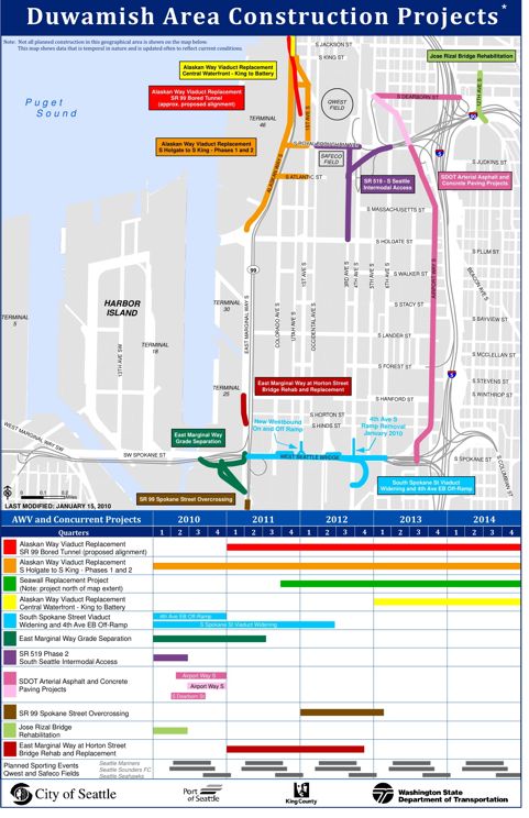
That map just sent around by Delridge Neighborhoods District Coordinator Ron Angeles; it expands on the map published here last night when SDOT sent out its latest news release about the upcoming construction-related closures on and around the Spokane Street Viaduct (aka the section of West Seattle Bridge between 99 and I-5). As you can see, this one includes some other closures right outside the general area covered by the original map/info. This expanded list can be found on the city website here – along with a larger, more readable version of the map. Most immediately, as mentioned last night, tomorrow’s the day that the 4th Avenue S. exit from the westbound SSV closes forever, and a longer stretch of lower westbound Spokane Street closes too; plus the West Seattle Bridge ramps from northbound I-5 and Columbian Way on Beacon Hill both will close for the entire weekend, 10 pm tomorrow through 5 am Monday.

7 Replies to "Update: Expanded look at upcoming area traffic troublespots"

  • chas redmond January 21, 2010 (5:09 pm)

    This is all certainly making us stronger and giving all of us more resolve. It’s giving me the impetus to explore really imaginative ways to cross the river. I can get over on Albro easily enough, now I have to learn the tricks of getting back.

  • Aye Jay January 21, 2010 (6:38 pm)

    This could make the water taxi valuable for some that are affected by the construction that normally wouldn’t use it.

  • wsnorth January 21, 2010 (6:41 pm)

    Will they keep the lower level bridge open to traffic during rush hours? It seems to close to traffic (open to boats) at random and remain closed for inexplicably long times.

  • forrest (with 2 Rs) January 22, 2010 (8:02 am)

    Maybe I’m just not seeing it on the list, but where are the details for the closure of the 1st Ave S on-ramp to the Spokane St viaduct?

  • brizone January 22, 2010 (2:07 pm)

    Can’t actually find that map on the city website, you’re linking out to the older one without the additional colors and project listing info below.

    Where can I find this “Duwamish Area Construction Projects” map?

    • WSB January 22, 2010 (2:18 pm)

      They keep changing. I’ll look. And if not, I’ll upload the largest possible version of the one that came via e-mail …

Sorry, comment time is over.