West Seattle, Washington
15 Wednesday
Here’s hoping you are already ready for the stormy weather that’s on the way. But storm trouble is just one of the challenges you need to be prepared for. And you’re invited to find out about being ready for almost anything, via a free class that longtime WSB sponsor John Moore @ Northwest Insurance Group is presenting later this month:
6-8 pm Monday, October 24th @ The Kenney (7125 Fauntleroy Way SW):
Northwest Insurance Group is sponsoring a Disaster Preparedness Presentation and will have a guest speaker from the American Red Cross. Lucia Scordamaglia will bring sample supplies/kits and provide plenty of information and handouts addressing how to best prepare for winter storms, earthquakes, house fires, flooding, landslides, and other disasters that disrupt our day-to-day lives.
RSVP to John Moore – johnm@nwinsgroup.com
Get your RSVP in ASAP to be sure there’ll be room.
It’s the last week of Preparedness Month and we have two related notes today:

RED CROSS LESSONS: That trailer is parked by Hope Lutheran Church right now because of what’s happening inside: With the help of the West Seattle Emergency Communication Hubs, local churches that participate in the Westside Interfaith Network are learning from the Red Cross about “how a faith-based organization would set up a temporary shelter for local people while the bigger, official response to a big disaster gets organized.” While the Red Cross’s mission is to help, it’s a supporting role, and in case of disaster, churches and other community organizations will be on the front lines first.
DISASTER RELIEF BIKE TRIALS: When Seattle Summer Parkways gets going on Alki tomorrow at 11 am, that also will mark the start of the Disaster Relief Bicycle Trials. If an earthquake (among other things) strikes, roads might be impassable to larger vehicles, but bicycle riders can go where cars can’t, and so the Seattle DRT is geared toward giving riders some practice for the possibility of having to help someday. Four West Seattle Emergency Communication Hubs will be “activated” for the occasion, and the ride also will include activities such as “Zombie Apocalypse Survival.” (Who can resist that?) Ride if you can; cheer them on if you can’t, 11 am at the main stage area of SSP near 61st SW/Alki.
 September is Preparedness Month. This year brings more than the standard – and important! – reminders about disaster kits – it also brings the 2016 Seattle Disaster Relief Trials, starting from Alki Beach during the Seattle Summer Parkways event three weeks from today. Here’s the official announcement about what organizers describe as “a disaster drill in the form of a cargo-bike ride, simulating a Day 3 supply run”:
Seattle’s Disaster Relief Trials (DRT) will take place Sunday, September 25th, 2016 and will run from 11:00 AM to 4:00 PM, starting from 61st Ave SW and Alki Ave SW in West Seattle. This year, the Seattle DRT will be held in partnership with Seattle Summer Parkways, Seattle Emergency Hubs, and the Seattle Auxiliary Communication Service (ACS).
Imagine the impact a nearby 8.5 magnitude earthquake and subsequent tsunami would have on Seattle. Buildings collapsed, roads in shambles, people displaced, services disconnected. Without roads that are passable to vehicles, how do we provide essential services to injured and scared residents?
The DRT is a fun emergency-preparedness event that mobilizes bicyclists to carry cargo representing emergency supplies to and from six checkpoints, Community and Communication Hubs and other significant community gathering locations throughout West Seattle and White Center.
Each of the six hubs will include a cargo activity for the Responder class, and an emergency response mini-workshop for the Resilient, Family, and Citizen classes, as well as for the public. The emergency response activities will be provided by partnering organizations.
The goal is to provide a realistic practice of how bicyclists can be a vital link in providing supplies to citizens, in cases where the roads are impassable to larger vehicles, within the context of educating the public and having a great time!
Tickets are now available. We are offering different ticket types indicating your level of participation (Responder, Resilient, Family, Citizen, etc.). Tickets range from $0 – $20. Most tickets include a free stylish 2016 DRT shirt you can wear year round!
Want to help out with the event? We are seeking volunteers to help with registration, setup, running checkpoints, and teardown. Volunteers will receive free snacks and water and a stylish 2016 DRT shirt, and will have the opportunity to learn valuable preparedness skills!
If you would like more information about this topic, please email us at info@SeattleDRT.org. If you’d like to volunteer to help with this event, please email us at volunteerDRT@gmail.com.

(WSB photos)
No helicopters at this earthquake drill – it was all about the people. Neighborhood Emergency Communication Hubs around the city “activated” today, including the one behind Neighborhood House’s High Point Center.
We previewed this one earlier in the week – “citizen actors” were sought to help, and organizers tell us more than 70 volunteers showed up. But it wasn’t the stereotypical drill where volunteers were splayed out on the grass hamming it up, pretending to be hurt – in this case, they were asked to show up with a specific request for information or help, and work their way through the hub setup. In some cases, they were assessed for the skills they could offer:
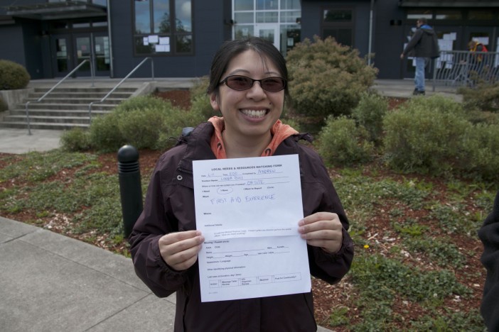
That’s Lynda, who has first-aid skills and multiple language skills – both of which would be useful in case of catastrophe. And of course, there was a radio tent too:
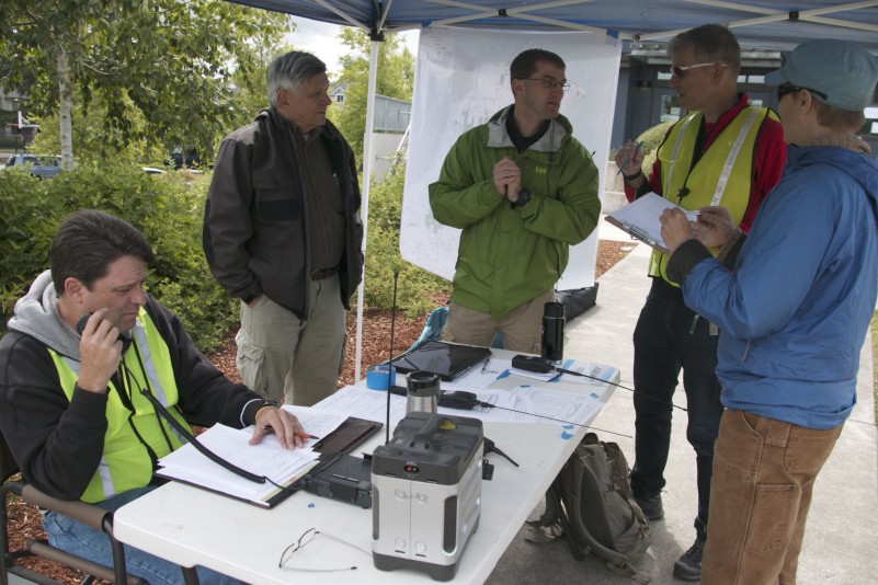
The High Point hub was in communication with other hubs around the city, as would happen in a real disaster. The hubs are meant to be places where neighbors can help neighbors, knowing that if something major happened, the official rescuers would be stretched too thin to come to the rescue immediately, if ever.
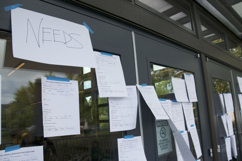
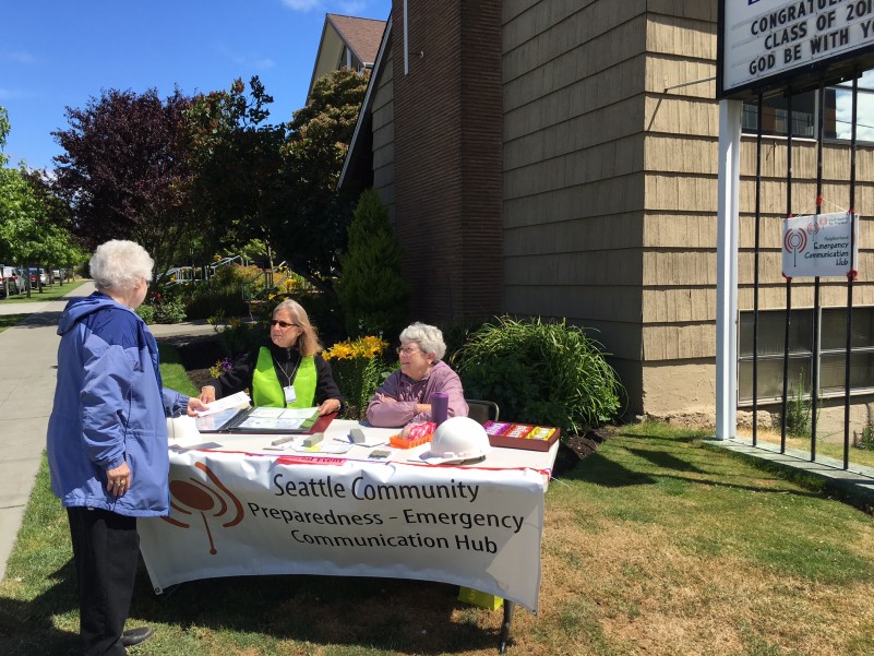
So be sure to know where your nearest hub is (see the map above) – just in case. And if there’s not one near you, consider volunteering to organize one – West Seattle’s newest hub, by Hope Lutheran in The Junction, had an info-table today just to start raising awareness:

If you went to the overlook at Jack Block Park expecting to see nonstop activity during today’s aerial-rescue drill, you would have been disappointed. But every so often, helicopters did take off – during the span of about half an hour, we saw the military chopper above, as well as the Airlift Northwest medevac helicopter below:

On the otherwise mostly empty expanse of T-5 – popular with drills since it’s closed as a cargo terminal while the port prepares to expand its facilities and capabilities – land-based emergency vehicles were in view, including a Seattle Police Mobile Precinct larger than the van-style one based at the Southwest Precinct.

Seattle Fire led today’s drill and tweeted a photo of the big show (which came after we had already left to check out the Myers/Olson car flip) – rescuers hoisted on a platform:
Air platform used to transport rescuers including search dogs during regional drill at Terminal 5. pic.twitter.com/yzNwq0wjfC
— Seattle Fire Dept (@SeattleFire) June 11, 2016
(You might also have seen some of the aerial activity in southeast West Seattle – while covering the aforementioned crash, we spotted the same military helicopter over SFD’s Joint Training Facility.) This was part of Cascadia Rising, the weeklong regional drill – years in the planning – practicing scenarios based on the 9.0 megaquake that scientists think will hit someday.
This morning we also stopped by the grass-roots Emergency Communication Hubs drill that happened citywide, including a West Seattle location, and that report’s coming up.

(WSB photo from November 2015, helicopters at Terminal 5 during drill)
Just got more information about tomorrow’s drill at Terminal 5, which noted here last night after we found out about it from a Port rep. The lead agency is Seattle Fire, which just sent this:
Imagine a 9.0 earthquake so devastating that it impacts the entire Northwest Region. That is the basis for the Cascadia Rising earthquake exercise being held this week in multiple states. When a disaster of this magnitude strikes, a regional air response is necessary to face the challenges of saving lives over a large geographical area.
The Northwest Regional Aviation team will come together at the Port of Seattle Terminal 5 for a daylong series of helicopter drills that will utilize lifesaving skills necessary to meet the challenges of a regional disaster. In coordination with the Washington State Department of Emergency Management, a unified response with aviation resources from 10 different city, county and state jurisdictions including 6 aircraft will demonstrate the technical aspects of search and rescue, moving resources and transporting injured patients.
Observe landing and take-off procedures as multiple helicopters hoist and transport equipment and personnel in and out of the heliport base at Terminal 5. The community is invited to watch the helicopter rescue activities from the view platform located at Jack Block Park.
Agencies participating in the training:
Airlift Northwest
Bainbridge Island Fire Department
King County Sheriff’s Office
Port of Seattle
Seattle Fire Department
Seattle Police Department
Snohomish County Sheriff’s Office
Tacoma Fire Department
Washington National Guard
The drill is scheduled to start around 10 am and continue until about 2, according to SFD’s media advisory.
Also happening tomorrow in West Seattle as part of Cascadia Rising – two Emergency Communication Hubs events – details are in our preview.
Just found out tonight that Terminal 5 will host yet another drill with helicopters on Saturday – this time, as part of the Cascadia Rising megaquake drill that’s been happening at a variety of locations around the region. Susan Stoltzfus with the Port of Seattle told us about it at tonight’s T-5 Draft Environmental Impact Report public hearing (report to come). She says multiple agencies are participating with simulations including a collapsed building, and it’s scheduled between 10 am and 3 pm. If you’re interested in taking a look, she says you’ll be able to view it from the Jack Block Park overlook. In the meantime, if you notice the helicopters and/or other unusual activity at T-5 on Saturday, don’t fret, it’s only a drill.
P.S. As we’ve already reported, a much-more low-key – but no less vital – drill will be happening in High Point, and your direct participation is welcome – here’s where, when, and how.
You might have heard about the big regional earthquake-preparedness drill that’s under way in a variety of places all week. Here’s how you can help: Join your West Seattle Emergency Communication Hubs volunteers this Saturday! Above is the map of all “hubs” – explained here – in West Seattle, but just one needs volunteer help – read on!
Come see what your community is doing to be prepared in the event of a major disaster. Join us in a simulated earthquake neighborhood response drill of the Seattle Emergency Communications Hubs.
We would love for you to stop by as a “put me to work” volunteer or as a Citizen Actor (to give us tasks to perform, you will draw a short script from our bowl of misfortunes). This will help test how we accomplish our mission and to help you learn how you can be ready to help in the event of a disaster!Participating Hub drill location in West Seattle:
Neighborhood House High Point Center
6400 Sylvan Way SW
9:30 am – 11:30 am
Also on Saturday, separate from the simulation, but ready to meet neighbors and talk preparedness:
New Hub location holding an open-house booth:
Hope Lutheran Church
4456 42nd Ave SW
9:00 am – noon
New Hub! Info table onlyFor more information about how to be prepared and what the hubs do, visit us at West Seattle Be Prepared.
15 years ago this morning, at 10:54 am on February 28, 2001, the 6.8-magnitude Nisqually Earthquake hit. Here’s some of what it did in West Seattle.
Nothing anywhere that big has shaken us since. But someday, sometime, one will. So we’re talking today about being ready. This map can help:
The markers on it – 13 of them now – show you the sites of West Seattle Be Prepared‘s 13 Neighborhood Emergency Communication Hubs. Find the one nearest you – and make sure everyone you care about knows about it. (If there’s not one near you, you can help launch one.) If a huge disaster hits, and the usual communication channels are cut off, these are places you can go to find out how to get help, how to offer help, etc., as explained here (and in even more detail here).
Our area was a pioneer in the “hubs” movement, which has expanded to other areas of our city, and is expected to continue growing. They’re for everyone, whether you’ve been here days, weeks, years, or decades – next month, for example, a hub-training event is planned for one of our area’s bigger new apartment complexes, as the hub in The Junction is finalized, and if it’s successful, it will be repeated for other interested apartment communities in the area.
Being ready, ultimately, is personal – have a kit, have a plan. This isn’t something someone will do “for” you. West Seattle Be Prepared is a volunteer community effort. We checked with its organizers to find out what else is new regarding local preparedness, as we mark the quake anniversary today.
This year, WSBP’s Cindi Barker tells us, is about partnerships and getting connected:
*They’re working with local churches about being partners in preparedness and in response in case it’s needed – including how to become a Red Cross shelter
*You’ll see WSBP at spring/summer community festivals as usual – starting with the West Seattle Bee Festival on May 21st and the Morgan Junction Community Festival on June 18th
*In June, WSBP will host a Business Continuity workshop for members of the West Seattle Junction Association, Barker says, “to teach our local businesses what a Business Continuity Plan is, why it’s important and point them to free-ware so they can either do one with us at a follow-up brown-bag event, or so they can do it on their own.”
*Also in June, some of the West Seattle hubs will be part of a major citywide drill on June 11th, “in loose conjunction with the big Cascadia Rising regional exercise” (which is happening June 7-10th, playing out the scenario of a megaquake/tsunami)
*Potential fall event related to what Barker says “is a training program being released this summer for local medical clinics and personnel, to teach them about their important role in the communities during a disaster.” As she says, the bottom line remains, they’ll be needed!
SPEAKING OF BEING NEEDED:
*Are you a ham-radio operator? Know someone who is? The Auxiliary Communication Service needs more in West Seattle to become part of the team. E-mail seattleacs1@gmail.com
*Part of a SNAP (Seattle Neighborhoods Actively Prepare), Block Watch or CERT group? Put yourself on the citywide map to get connected!
SPEAKING OF GETTING CONNECTED:
*Along with the West Seattle Be Prepared website, WSBP has a Facebook group.
P.S. If you didn’t know – there’s an online seismogram at Alki Point; you can check any time for recent quakes around the region by going here.
Even if you didn’t feel it, the Vancouver Island earthquake late last night is another wakeup call reiterating the message that we all need to be ready, because someday we’re going to shake in a big way. So here are two maps you need to see. First, from West Seattle Be Prepared:
KNOW YOUR NEAREST WEST SEATTLE EMERGENCY COMMUNICATION HUB: Especially if you’re new to WS, this might be news to you. Preparedness volunteers in our area have been regional leaders in this unique aspect of preparedness – organizing “hubs” where you can go in case of catastrophe, to get information and seek help if the regular communication channels are down/damaged/unreliable. Click a spot on the map to get information on the location where volunteers plan to set up a hub if and when disaster strikes. If you don’t see one relatively close to you, that’s only because no one has come forward to lead the way in your area – here’s how you can help! And take some time to browse the WSBP website, which is an excellent resource packed with a variety of preparedness-related info.
Now, the second map you should see. You might have already taken a look, as this new city map was circulating in the days just BEFORE the quake:
SEATTLE NATURAL HAZARD EXPLORER: The city-produced map takes you through a variety of types of “natural hazards,” including earthquake risk, as explained in Seattle Times science reporter Sandi Doughton‘s story earlier this week. You can see the map (really, it’s more than a map) fullscreen by going here; in the condensed version above, you can use the arrows at the bottom to scroll through types of hazards. In each category, click the “i” at top right to open up a text box with information at the bottom of the map, including a tab that explains the map’s legend for that section. Among other things, the earthquake-risk view shows where the Seattle Fault travels through our peninsula.
 Rare chance to tell you way in advance when and why helicopters are expected in the area. The Port of Seattle just announced that multiple agencies also including Seattle Fire, King County, and Snohomish County “will be conducting a joint exercise involving multiple helicopters for emergency preparedness training” on Monday at Terminal 5. This exercise, the announcement says, “will give the participants better training for rescue situations such as those that took place after the Oso mudslide in 2014.” The helicopter activity, “moving heavy loads of equipment and personnel,” is expected to last from 11 am to noon on Monday (November 16th).

Even if you weren’t part of Thursday’s statewide earthquake drill – you can get your preparedness going ANY TIME. Here’s some inspiration – at Explorer West Middle School (WSB sponsor), the drill went far beyond the actual “imagine there’s a quake” moment. Out on the field, they set up a makeshift hospital. And some students portrayed people in major need of treatment.

This was all organized by teacher Timothy Owens, who explained it to us on camera:
(The call Owens took at the end of our chat, by the way, was from the school’s brand-new phone-alert system, which gets messages to families in case of emergency.) The drill was based on a long-lasting quake. Students took cover under their desks, then went out on the field, for a drill running about 45 minutes, followed by a debriefing; regular classes resumed after lunch.
P.S. If your earthquake/disaster preparedness is lagging – don’t feel guilty, you’re not alone! – a great place to get started, with local info, is West Seattle Be Prepared – be sure to find your nearest emergency communication “hub”!
Though November might seem far away, the city’s earthquake-preparedness presentations tend to fill up fast, so we’re sharing word of this one in case you want to sign up:
Are you prepared for the next big earthquake and other disasters Seattle could face? Attend a presentation at one of the below library branches to hear from local emergency management experts about what you can do to get prepared. Learn about the City’s new emergency alert and notification system – AlertSeattle – and bring questions to ask the City’s hazard specialist during an open Q&A session.
Wed. November 4, 2015
5:30 p.m. – 7:00 p.m.
Southwest Library BranchRegister for a class by emailing your name and the presentation you plan to attend to snap@seattle.gov
Did you feel it? We heard from one person south of Alki Point who said they did – a 4.0-magnitude earthquake at 3:22 this afternoon, epicenter east of North Bend. Lots of info here – and if you DID feel it, tell the scientists by filling out this form. The quake gives us a reason to remind you that September is Preparedness Month – and at the very least, you need to know where your nearest Emergency Communication Hub is.
Know where your nearest Emergency Communication Hub is? Know WHAT your Emergency Communication Hub is? West Seattle has long been a citywide leader in this aspect of preparedness, via West Seattle Be Prepared. And they’re sharing news of a presentation downtown tonight that might interest you. Usually we can only promote on-peninsula events, but preparedness has been a signature issue for us for a long time, and at the heart of this presentation is the reminder that community can be key in case of catastrophe:
Join the Seattle Emergency Communications Hubs and Seattle Fire Dept. Battalion Chief Tom Richardson, one of the Urban Search and Rescue Team Leaders (USAR) at the SR 530 slide, who will share his experience during the response and recovery stages and his thoughts on how communities are key in disasters.
Program
6:30 pm – (Optional) Overview of the Seattle Emergency Hubs
7:00 pm – Program start
8:00 pm – Q & A and discussionLocation: City of Seattle Emergency Operations Center, 105 5th Ave S. (Corner of 5th Ave S and S Washington St)
Please RSVP at snap@seattle.gov, or 206-233-5076
 The city has opened signups for AlertSeattle, which its announcement describes as “a new, real-time emergency alert and notification system … a way to send out messages to the public with information on what to do when emergencies like earthquakes, explosions, flooding, or other disasters happen,” as well as “community notifications about severe weather, safety, health, utility-service disruptions, major traffic incidents, preparedness events and more.” You can register by going to alert.seattle.gov and creating a profile. Set aside a few minutes before you start – it’s a bit complicated, with numerous optional fields you can (but don’t have to) fill out beyond the basic notification information; it’s linked to Smart911, so you’ll also be asked, for example, if you want to provide information about your household that could be displayed to emergency providers if you call 911 from the phone number you register.

They’re not quite burning the midnight oil, but close. Local emergency-preparedness volunteers will be in view at Ercolini Park west of The Junction and Hiawatha Playfield (above) in Admiral until about 10 pm tonight as part of a citywide drill. We stopped at both before sunset. The drill scenario: A BIG quake, with the Neighborhood Emergency Communication Hubs on Day 3, working to communicate information and procure help. Listen in to a snippet from Hiawatha:
We listened in for a bit at Ercolini too:
Ham-radio operators are on site at each participating hub this time for the first time, according to West Seattle Be Prepared.

Volunteers of all ages were welcome, and were assigned roles including “greeter” and “message taker” all to be ready just in case the unthinkable happens and the hubs have to be set up because other ways of communication aren’t working:

That was the whiteboard at Hiawatha, which we visited a while after our stop at Ercolini:

While these were the only two hubs “activated” for tonight’s drill, West Seattle has ten others – check this map to find the one closest to you:
And learn more about the hubs at westseattlebeprepared.org.
The magnitude-7.8 earthquake in Nepal is now reported to have killed almost 2,000 people. And a difficult, dangerous time is ahead for the survivors who now must figure out how to get through its aftermath and aftershocks. So tonight, a reminder about local preparedness:
You need to know where your nearest Emergency Communication Hub is – and that map will help. West Seattle volunteers have led the way in organizing hubs around the peninsula. The hubs are places you can go in the aftermath of a disaster that shuts down usual communications, places to find information and help, as explained on this page of westseattlebeprepared.org – and on a citywide level, they’re explained in this video:
The video mentions the drills that hub volunteers stage every so often to make sure plans and procedures will be fresh if and when disaster strikes. Just so happens that the next drill is two weeks from today, Saturday, May 9th – an evening drill this time, 5-10 pm around the city. The drill scenario will be “a major earthquake followed by aftershocks and worsening weather conditions. The exercise will test operations, procedures and equipment, offer opportunities to learn and to get to know fellow volunteers.” West Seattle Be Prepared‘s Cindi Barker shares this flyer showing that two WS hubs are participating, Ercolini and Hiawatha, and explaining how you can help, even if you haven’t been involved with a hub before:
Hub volunteers and radio operators with the Seattle Auxiliary Communications Service will be among those participating.
In the meantime, here’s one more *very important* thing you can do even if you are not involved with a hub: A new website has launched in an attempt to get various community safety and preparedness-related groups communicating and coordinating – Hubs plus SNAP, CERT, and Block Watch groups. If you’re involved with any of the above, go to seattleemergencyhubs.org, find the Emergency NeighborLink Map on the home page, and get signed up so your group will show up.
P.S. If you haven’t even taken the basic preparedness steps – emergency food/water supplies – don’t feel overwhelmed. The Seattle Neighborhoods Actively Prepare (SNAP) website has some advice – see this page.
Want to make your house more earthquake-resistant? Two chances to learn about retrofitting are coming up in West Seattle as part of the Seattle Neighborhoods Actively Prepare (SNAP) program. They’re free, but you do have to register. First one is next Sunday (April 19th), 2-4 pm, at the West Seattle (Admiral) Branch Library – full details here; e-mail snap@seattle.gov if you’re interested. After that, another one is set up for 2-4 pm May 2nd at the High Point Branch Library; same registration address.
Tuesday night, the Junction Neighborhood Organization meets – and it’s not just a chance to hear and talk about projects and issues in the area, it’s also a chance to help your neighborhood be prepared! From Ellen West:
Earlier this year, JUNO committed to joining with West Seattle Be Prepared and to create a Emergency Communication Hub in the Alaska Junction area. We’ve approached Hope Lutheran, who will partner with us on hosting the Hub location. So now we’re ready to form the Hub team and start training with the other West Seattle Hubs. Please come to the next JUNO meeting on Tuesday, October 21st, 6:30 at the West Seattle Senior Center, 4217 SW Oregon, to become a volunteer for this important work! For more information, please e-mail Ellen, ellenwestchina@gmail.com
Haven’t heard about the Hubs? They’re explained at westseattlebeprepared.org – go here.

Because of its pioneering Emergency Communication Hubs, West Seattle is a regional leader in neighborhood-based emergency preparedness – and that was affirmed by an award presentation this afternoon at Fauntleroy Church. On behalf of the Community Hubs citywide, Cindi Barker from West Seattle Be Prepared accepted the King County Executive’s Award for Community Preparedness, presented by KCE Dow Constantine. Those on hand got a demonstration of scenarios that the all-volunteer Hubs are meant to handle, and the kinds of information and resources they would coordinate:

The award honors the Hubs for “going beyond the basics, to promote disaster survivability and build community resiliency.” Also there, a city rep with whom they have worked closely, Debbie Goetz:

And we can’t talk about the hubs without again showing you the map of where West Seattle has them:
They’re explained here – locations chosen by neighborhood groups, designed to be set up in case of catastrophe that interrupts regular ways to communicate. You need to know the closest one to your neighborhood, so that you know where to go for information and help in case of disaster. If there’s not one anywhere near you – that’s because no one has stepped up to get it organized – contact WSBP if you’re interested in making one happen!
P.S. We’ll add video of today’s award presentation once it’s uploaded back at HQ. (Added – here it is:)
October is Disaster Preparedness Month in our state, and how timely; regional water woes – this morning’s Delridge pipe break, and the recent Mercer Island scare – are a reminder that you need to have an emergency supply of water on hand. From West Seattle Be Prepared:
The recent challenges to our normal water supply reflect the importance of being prepared for emergencies. Sometimes an emergency can be small, like a day where the water is shut off, or bigger in scale, with complete disruption or like the recent “boil water” notice on Mercer Island. Stores in Mercer Island quickly sold out of bottled water and residents were dragging out pots to boil water. This would have been a perfect time for those residents to dig into their 3-day (or more) stash of water set aside for emergencies, as part of their emergency preparedness kit. Using that water, while waiting for normal service to return, would have prevented panicked searches for bottled water supplies at the stores or the inconvenience of boiling water for multiple days. The additional benefit is that once you used your supply up, in the Mercer Island case, the stores would have received new shipments AND you can replace your stored water with a fresh supply, and your emergency-kit water is now good to go for another 6 months before normal cycling.
So what should you do to secure that water stash? We covered that during our special preparedness reports last year – check it out here.
In light of today’s Northern California earthquake – we have two preparedness reminders. First, do you know where your Emergency Communication Hub is? The map above is courtesy of West Seattle Be Prepared, local volunteers who have worked for years on helping facilitate local neighborhood preparedness. The hubs are explained here – in short, the place you would go if regular communication channels/methods weren’t working in the aftermath of a disaster (big quake, storm, etc.). If there’s no hub near you, it’s because no one has stepped forward to set one up – this is an all-volunteer effort; here’s how to get one going.
Second, the city offers classes to help you retrofit your residence to make it more capable of withstanding a quake, and as mentioned on WSB recently, registration is open for one coming up this fall – info is here.
| Comments Off on BE PREPARED! Not just for storms: Free class in West Seattle