West Seattle, Washington
18 Saturday

(Photo by Jim Clark)
That might have been the last red sunset for now. From the National Weather Service tonight (caps are theirs): “GOOD NEWS. DEVELOPING LOW LEVEL ONSHORE FLOW THIS EVENING HAS BEEN FLUSHING OUT THE SMOKE IN MUCH OF WESTERN WA WITH FRESHER PACIFIC OCEAN AIR. VISIBILITIES AND AIR QUALITY HAVE BEEN IMPROVING THIS EVENING.”

(Photo by Tiff Rivera)
Unfortunately, of course, while the air clears here, the fires rage on – almost 800,000 acres involved in “active” fires on the InciWeb list.

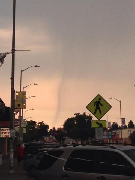
Thanks to Ann Anderson for the view (from Seattle & Sunset in North Admiral) of tonight’s smoky sunset. People are still finding it hard to believe, but it’s true – what you see and smell is all smoke from the wildfires raging around the state, mostly to the east. We featured moonset and sunrise views this morning along with Cliff Mass‘s explanation and the Puget Sound Clean Air Agency‘s forecast for the wind to “reverse” tomorrow”; the National Weather Service says tonight that changing flows might not clear it out until late Sunday. More photos to add later!

(Friday night photo by David Moya)
Yes, that’s wildfire smoke coloring our skies – yellowish haze right now, last night’s moonset (above), today’s sunrise (below) …

(Saturday morning photo by Craig Young)
If you’re sensitive, you probably have even noticed a smoky smell in the air – two people messaged us last night from different areas of West Seattle, wondering if there was a major fire close by. You can find many images and explanations on the Web, but the most comprehensive combination we’ve found so far is from weather analyst Cliff Mass, who published this update on his site, headlined, “Large Smoke Cloud Heads for Puget Sound.” (Puget Sound Clean Air Agency expects the wind to change tomorrow, improving the air quality here.) For information on specific fires, InciWeb is a good source (other suggestions welcome!).

Thanks to James Bratsanos for sharing tonight’s sunset view … still a month-plus of summer nights left, even as the sun makes its exit a little earlier each evening, already almost an hour earlier (8:18 pm tonight) than the latest summer sunset (9:11 pm on July 1st).
P.S. Check the sunset/sunrise and moonset/moonrise times on the WSB West Seattle Weather page, any time.
It’s been raining for about five hours now, and so talk has turned to wondering how much rain, and how much longer it’ll continue. The National Weather Service says totals vary widely, area to area – almost an inch at Sea-Tac this afternoon – and that showers will linger, but that after tomorrow morning, a “drier and warmer” trend will take over quickly, so weekend events – including West Seattle Outdoor Movies on Saturday night – should be OK. We’ve checked around this afternoon and besides the problems chronicled earlier – crashes and small outages – no major problems in West Seattle; as intense as this rain has been, it still fell into drought-depleted creeks, for example, so we’re not seeing any overflows. One more stat: More than 650 lightning strikes in Western Washington, per the NWS.
3:02 AM: Yes, that was thunder you just heard (maybe it woke you up). We noticed lightning to the southwest a little while ago, and now the thunderstorm is getting closer. This short-term weather alert from the National Weather Service says the activity is likely to continue until 5 am or so; showers are expected throughout the day, with up to a quarter-inch of rain, per the newest forecast.
5:07 AM: Another thunderstorm is moving through right now.
Thanks to Flint Hayes for sharing time-lapse video recorded during yesterday’s off-on storms – no lightning, but notice how suddenly the first showers seem to just drop from the clouds! The vantage point is from Flint’s home near 35th SW and Avalon, north of West Seattle Stadium. More rain expected tomorrow, by the way!
11:32 AM: Thanks to Darcey for that photo, tweeted from White Center, looking south. She sent it just as thunderstorms are moving through the area. The National Weather Service issued a short-term alert a few minutes ago, saying this is likely to last for the next hour or so.
NOON UPDATE: The rain intensified but is now getting lighter, as is the sky. Meantime, weather analyst Cliff Mass showed a different perspective of what you see in Darcey’s photo above, and noted that what’s seen from the clouds is “virga.”

(Another perspective, from Barb)
12:15 PM UPDATE: Rain’s stopped, sun’s out. That was enough rain for puddles on the road, though. Also: Seattle Parks temporarily closed all its outdoor aquatics facilities – Colman Pool included – because of the thunderstorm and lightning danger. We’ll update if we get word they’re open again. Parks says the wading pools will NOT reopen, “because of the time and water it takes to drain and re-fill them.”
1:25 PM: The clouds rolled back in again and we’ve just heard more thunder.
1:49 PM: The first round of rainfall was a pretty decent dousing, says the NWS:
The 0.45 inches of rain between 11 and noon at Sea-Tac is the most rain there in one day since April 13th
— NWS Seattle (@NWSSeattle) August 12, 2015

If you were lucky enough to watch it in real time, you know tonight’s sunset had two stages – the first, shown above in Jim Spraker‘s photo, was a beautiful pastel pink – and then, instead of fading from there, it deepened, as shown in Chris Frankovich‘s photo below:

Might just have been a reminder that tomorrow could bring an encore of 90-degree weather, after which things are scheduled to get back to “normal.”
Second night in a row, everything’s coming up Blue …

Chris Frankovich shares tonight’s moonrise, still the “Blue Moon” … (Added) Mike Jensen‘s view includes a state ferry (at Vigor) in the foreground:

Here’s why it’s called a “blue moon.”
And from this afternoon’s Seafair airshow practice, Karin shares a Blue Angels flyby:

She was at work on Mercer Island when she took the photo.
Saturday’s Blue Angels (etc.) schedule:
*I-90 bridge closed 11:50-2:40 pm
*Blue Angels go up in the 1:30-ish vicinity (could be earlier, could be later) – watch for support C-130 “Fat Albert“ first; we noticed it making a few passes over West Seattle in the 1:25 pm vicinity today
*Other Seafair airshow acts might be visible from here, especially if you’re looking toward Boeing Field from eastern West Seattle (or watching from along the Boeing Field runway) – here’s the schedule/list

Thanks to Mike Jensen for sharing that view of a bald eagle hanging out in a tree by Me-Kwa-Mooks Park, watching tonight’s sunset. You might want to identify a shade tree of your own for the next few days, because the National Weather Service has announced a “heat advisory” alert for noon Thursday through 9 pm Saturday – all three days are expected to have high temperatures in the 90s (and Sunday won’t be too far behind).
P.S. If you want a different perspective on 90-degree heat … note that today was the sixth anniversary of the hottest day in recorded Seattle history, when the high hit 103 degrees.

5:24 PM: If you hadn’t noticed it’s been raining for the better part of an hour – the thunder might have startled you. The National Weather Service does have our area under a “short-term forecast” alert, including thunderstorms and possibly even “small hail.” (On the literally bright side, the forecast says sun returns Tuesday and continues through Seafair’s big weekend.)
5:57 PM: Added a photo shared by Lise Thivierge, who says the neighbors were out “celebrating the rain.”

After our area’s biggest day of summer fun – a mesmerizing moonset, with Venus in view. Thanks to David Hutchinson for the view from Alki Beach, above; below, Gary Jones caught a slightly later view from Alki Point:

P.S. You can check the moon phase and moonset/moonrise time (along with sunset/sunrise) any time on the WSB West Seattle Weather page.

(Photo by Lura Ercolano)
A show in the sky as we head into another big weekend of summer fun – with 90ish highs forecast to return.

(Photo by Greg)
Thanks for sharing the photos! (editor@westseattleblog.com)

9:27 PM: As the forest-fire smoke continues to linger, tonight brought another vividly hued sunset. Thanks to James Bratsanos for the photo. Don’t count on a three-peat tomorrow – the National Weather Service‘s forecast discussion says tonight that “the smoke should leave the area Thursday morning as flow aloft becomes more southerly.”
ADDED 9:36 PM: Thanks to Jamie Kinney for this view:


Smoke from fires to the north of us filtered tonight’s sunset in a big way – enough to see sunspots in some of the views we received, including the one by Neal Chism, above. The big pink moon sun was just a disc suspended in the sky for a while, as shown in John Bartell‘s photo …

… until, as shown in Long Bach Nguyen‘s photo below from Gatewood, it edged behind the Olympics:

Long also shared a sunspot view – note the band of smoky haze:

You might recall similar sunset views back in April, when smoke drifted this way from fires in Siberia.

(Photo by James Bratsanos)
A hot-pink sunset starts another hot night. The National Weather Service‘s “heat advisory” alert for our area is now extended until at least 9 pm tomorrow; the NWS also made this observation, “An interesting climate stat: Sea-Tac Airport averages 3 days of 90 degrees or better per year. Today’s high of 93 was the third day of 90-plus this year, and it is only July 2nd.” (An NWS tweet adds that it’s been 80+ for five days in a row, 15 of the last 30.) We’re still in the 80s right now, and it’s after 10 pm; the forecast still says Sunday will be the hottest day of the week, mid-90s.

(Added: Photo by John Hinkey)
P.S. If you have an eastern view, the full moon has risen!

That’s the late-afternoon scene at E.C. Hughes Wading Pool in West Seattle, which opened for the season today; from here on out, it’s the full wading-pool schedule for the rest of the summer. Just in time, too, as the warmer-than-normal weather continues; the National Weather Service has the city under a Heat Advisory until Thursday night, with temperatures potentially reaching into the 90s again tomorrow.

Tonight, no excuse for running pretty sunset photos – no weather alerts, for example – James Bratsanos just happened to share the photos, and with the holiday on the way, a sunset-pic break just feels like the right thing to do before the next few stories we’re working on.

Forecasters now say the 4th of July is expected to get into the mid-80s, cooling a bit from temps that they believe will peak on Thursday in the low 90s.
It’s hot already – 86 degrees at the top of the hour, according to the closest official National Weather Service gauge at Boeing Field, and this isn’t even typically the hottest time of day. But the NWS now verifies it’s going to get hotter, and has issued an Excessive Heat Watch alert for Friday/Saturday – see it here. By Saturday afternoon, it could be into the mid-90s, says the NWS. The mayor’s office, meantime, has published a list of “cooling centers,” including, in West Seattle, the Delridge (5423 Delridge Way SW) and High Point (35th/Raymond) branches of the Seattle Public Library, and the Senior Center of WS (Oregon/California). We’ll be compiling a list of other air-conditioned locations – editor@westseattleblog.com – thanks!

Thanks to Lynn Hall for capturing the end of the longest day of the year, almost 12 hours after the arrival of summer. Tonight’s sunset came 16 hours after sunrise; now the days start getting a bit shorter, as Alice Enevoldsen explained at last night’s quarterly Solstice Park sunset watch. Most notable in the days ahead: The forecast suggests hotter weather next weekend – upper 80s on Sunday.
(added) Wider shot from Upper Alki, by JayDee:


9:23 PM: Thanks to Jissy for being the first to send a photo of the truly spectacular sunset that’s gracing the northwestern sky right now. We’ll add more if we get them! (editor@westseattleblog.com)
9:41 PM: Thanks to those who’ve tweeted …
Shades of scarlet conquering! #WestSeattle
#sunset. @westseattleblog WOW!! pic.twitter.com/Rvm1SRjXbW
— David Nyro (@DavidNyro) June 18, 2015
… and to those who’ve e-mailed. From Chris Frankovich:

From Darren Pilon, the sunset over the Arbor Heights Elementary construction site:

From Greg Snyder:

From Lynn Hall:

10:14 PM: Still adding – this one came in via text (remember we don’t see names with texts and don’t generally know your phone number on sight, so please mention your name so we can credit you!):

From Don Brubeck via e-mail:

And from Kristin Widman, taken at Salty’s on Alki (WSB sponsor):

Adding a few more when we get back to the keyboard in a bit – been dealing with breaking news.
12:37 AM: And two from beach level – this is from Paula G:

And from Jeremiah:

P.S. Speaking of sunsets … Saturday night, it’s Solstice Sunset Watch with Alice Enevoldsen, 8:45 pm at Solstice Park.

(Thanks to Karl for the rainbow photo from Westwood Village)
4:53 PM: Yes, that was thunder, as a storm cell moves through the area – we saw a big bright bolt of lightning a bit northwest of us a few beats before the boom. No special weather alerts but the forecast overall did warn of a chance of thunderstorms.
@westseattleblog Rainbow view from Admiral 'hood pic.twitter.com/sKHLSqwr9F
— Jason G (@jgrotel) May 6, 2015
5:13 PM: Longtime WSB’er “MetPatrick” is watching the charts and warns of another one that appears to be headed this way.
@westseattleblog Rainbow in the junction pic.twitter.com/pDUUJq4CyD
— NLB (@g7on) May 6, 2015
6:21 PM: Did you catch the hail (ice pellets) and downpour? If you use the Periscope livestreaming app, be sure to follow @westseattleblog – we were experimenting during all that. Meantime, thanks to everyone who’s sent rainbow photos – we’re adding a few here!
| Comments Off on West Seattle sunsets: One more time, before the smoke clears