
(Flashing fire signal at 38th SW that is planned for conversion into pedestrian-activated signal)
By Tracy Record
West Seattle Blog editor
With both walking tours for the Fauntleroy Boulevard project over, big decisions are ahead for the project.
We covered both tours – Thursday afternoon (here’s our report) started in sunshine; this morning had an even bigger turnout – “impressive,” as one SDOT staffer deemed it –
despite starting in steady rain.
The route and the stops were the same – from outside LA Fitness at Fauntleroy/Alaska/39th to West Seattle Brewing at 4515 Fauntleroy Way. The fact the project is focused only on that stretch is a disappointment to one of today’s participants, René Commons from the Junction Neighborhood Organization, who lives near the 35th SW entrance to the West Seattle Bridge and had been lobbying for pedestrian and landscaping improvements extending that far – not currently in the 60-percent-designed plan to transform Fauntleroy Way through The Triangle:
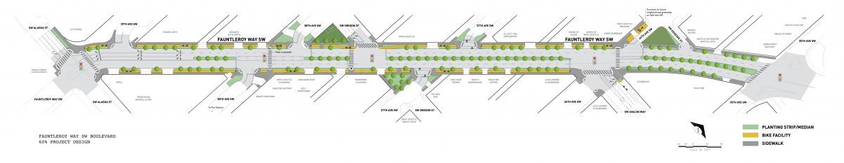
One of the decisions to be made about the entire stretch is what will happen during construction, which project spokesperson Kate Cole – who, like Thursday, led about half the participants on the tour, while her colleague Rachel McCaffrey led the other half – said is more likely to start in early 2018 than late 2017.
“It’s still early,” they stressed, repeatedly. And yet it’s not so early in the design phase, which got to 60 percent before the project was shelved in 2014 pending funding.
The full-route decision to be made involves detours during construction, which is expected to last at least a year. Right now, SDOT is mulling two options: Keep Fauntleroy open one lane each way, which could stretch construction out to 15 months, or keep it open to westbound traffic only, while eastbound traffic is detoured onto SW Alaska. Asked whether left turns would be allowed during construction, SDOT staff said yes. But limiting Fauntleroy to westbound traffic would be a challenge for businesses who have eastbound customers in the morning:

The other decision to be made is about the right-turn pockets currently proposed for elimination – onto SW Oregon on the westbound side, onto Avalon Way on the eastbound side:

With three years passing since the studies that led to the elimination decision, SDOT is doing new studies now, and McCaffrey says the results should arrive in about a month. When those studies for the 2014 design were done, project team member Peter DeBoldt said, they showed a “slight increase in congestion” with the removal of the turn pockets. But as tour participants pointed out, conditions in the area have changed – anyone who drives SW Oregon between California and Fauntleroy knows how much busier it’s become; the residential areas lining it have densified, with hundreds of apartments added by projects including Oregon 42 and Junction Flats, and townhouse/rowhouse projects replacing some of the single-family houses in the area.
So the traffic-study results will be awaited with interest; how those results will be communicated to you is still being decided, she said when we talked during the tour-end event at West Seattle Brewing.

And they’re still planning what they’ll do when the final design is complete, likely “early summer,” according to McCaffrey. (We of course will continue reporting on this, but she also suggested you join the project e-mail list.)
Right now, they’re also urging businesses to talk with the city Office of Economic Development, which had a rep at the end of the tour again today.

City Councilmember Lisa Herbold, who was on today’s tour (photo above), had said during the recent Fauntleroy Way Association launch meeting that she wanted to see OED get more deeply involved. But so far, there’s been no talk of possible business compensation, as was eventually offered during the controversial 23rd Avenue project in the Central District/Capitol Hill area.
“We’ve learned from the 23rds of the world,” McCaffrey said today, as she had on Thursday.
If you’ve missed the general summary of the Fauntleroy Boulevard project, here’s how Cole summarized it at the start of today’s tour:
That’s SDOT project manager Norene Pen at left in the video, in which Councilmember Herbold also gave a quick explanation of why utilities are being “consolidated” rather than undergrounded in the project.
The two big decisions we mentioned above aren’t the only ones remaining – along the route, SDOT acknowledged the request for a break in the median in the 37th SW vicinity, and said they have to evaluate the “tradeoffs” that might generate. And they continued to clarify project points along the way today; someone asked about curb bulbs, and project manager Pen said they’ll be used on side streets to shorten crossing distance, not to narrow Fauntleroy, where the travel lanes will be “about the same” in width, another question was answered.
Other questions remain about how this plan will interface with and anticipate a future that is still in motion – with much of the surrounding area zoned for development much higher than what’s currently in place, even before potential HALA Mandatory Housing Affordability upzoning, and with Sound Transit light rail due to come to West Seattle in less than a decade and a half, and station-location decisions to be made long before then.
HOW TO HAVE A SAY: To tell the project team what you think about the design, landscaping, and key questions such as which detour option to use during construction (or – do you have another suggestion?), scroll down the official project page to find a form. You’ll also want to look at the boards that were shown at tour’s end – here (PDF), or embedded below:
McCaffrey says they will also come out and speak with community groups by request – e-mail fauntleroyblvd@seattle.gov – as they did, for example, at last month’s West Seattle Transportation Coalition meeting.
| 4 COMMENTS