Without an accompanying storm, this morning’s “king tide” only rose to the bottom of the beach steps by the Alki Bathhouse – not high enough to swamp the Alki boardwalk the way the December 17th high tide did, four weeks ago:

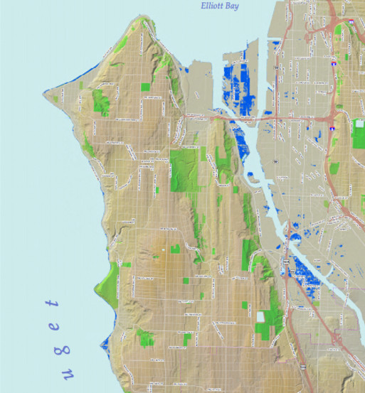
But right about the same time we took the top photo this morning, the city was going public with a warning that it won’t take a “king tide” to submerge some parts of Seattle’s shoreline in a few decades, thanks to climate change. Part of the warning involves this map:

(Click image for larger view)
That’s the West Seattle section of a map just made public by Seattle Public Utilities, showing areas where they believe the rising sea level will dramatically affect the shoreline by 2050 – less than 40 years. If you look at it full size and zoom in as closely as possible, you’ll see Harbor Island and the Duwamish River shores are potentially hardest hit (dark blue), along with the immediate Alki/Beach Drive/Arroyos/etc. waterfront. Here’s a closeup of the area northeast of Alki Point:

(See the map for the entire city by going here. Once you have it open, you can zoom way in to see areas shaded light blue for possible 6″ higher, dark blue for up to 44″ higher.)
This is all intended to bring attention to the city’s plan to try to lessen this area’s contribution to climate change, and ways in which they’re asking for your opinion on how to proceed:
The city news release says “conservative scientific assumptions” were used to develop the map, adding that “the impact on Seattle shorelines depends on factors such as tides and storms, along with actions the City may take to reduce its own contribution to climate change.”
City Councilmember Mike O’Brien, who chairs the Energy & Environment Committee, is quoted in the news release as saying, “We are already seeing impacts in Seattle from extreme events, such as last month’s flooding of some 100 properties along Beach Drive in West Seattle. We need to take bold steps to prepare our city for expected impacts and drastically reduce our contribution to greenhouse gases going forward.”
The Beach Drive flooding on December 17th, you’ll recall, was the result of a 13.1 “king tide” high tide coupled with a storm surge – leading to the highest high-water level ever recorded in Seattle. The tide was just as high today at 7 am, but without a storm surge – as shown at the top of this story – no flooding (that we’ve heard of).
The city points out it’s committed to becoming “carbon neutral by 2050.” To get there, the City Council is asking for your thoughts on a set of recommendations for a new Climate Action Plan, stemming from the Green Ribbon Commission convened recently. Public forums and an online survey are planned – and then, O’Brien says, the council plans “to adopt a bold Climate Action Plan on Earth Day, April 22.”
*The three public forums (all outside West Seattle) are listed here
*Here’s the online survey – asking you to prioritize from a list of possibilities.
*The “executive summary” of the commission’s recommendations can be read here.
In the meantime, the city announcement ends with a suggestion that if you live in a flood-prone area, you “are advised to obtain federal flood insurance from the National Flood Insurance Program, available through Federal Emergency Management Agency. The average flood insurance policy typically costs around $600 per year.”

| 10 COMMENTS