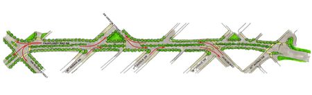
That’s one page from the presentation made to the City Council this morning by Junction business and development representatives – a vision for Fauntleroy Way as it passes through the area known as the “Gateway” or “Triangle” – potentially turning it into a tree-median boulevard. Read on for our full report on what’s being proposed for Fauntleroy, California, and Alaska in the area, including a dramatic new suggestion for how to stave off what many have called the “canyon effect” of the tall development for which much of the area is zoned:
Five months ago, we brought you this report noting that city and business leaders were strategizing what to do about the “Gateway” area; now, some specific ideas are coming to light, so West Seattle-residing Councilmember Tom Rasmussen arranged for a discussion during this morning’s “Council Briefing” session. But today’s discussion also went beyond the Gateway/Triangle area, with ideas for helping California SW survive the coming development wave too.
At the oval table in City Council Chambers with council members: West Seattle Junction Association president Dave Montoure (from West 5), Junction-based architect Brandon Nicholson, and Harbor Properties‘ executive vice president Denny Onslow. The council also heard from West Seattle Chamber of Commerce executive director Patti Mullen and Fairmount Community Association‘s Sharonn Meeks, and other local leaders in the audience likely would have spoken too if Council President Richard Conlin hadn’t noted at the end that the morning’s briefing session was running well into overtime (topics before this one had run long too).
Thanks to Brian Hawksford in Councilmember Rasmussen’s office, we have a copy of the visuals from the presentation that Montoure, Nicholson, and Onslow gave. See the whole thing here (individual images are interwoven with the story from here on out). It breaks down into three sections – first, California SW in The Junction; then SW Alaska through the Triangle and Junction; finally, Fauntleroy from 35th to Alaska (as shown in the sketch at the top of this report).
As Rasmussen said at the start of the discussion, “I think the West Seattle Junction has an opportunity that may be unprecedented for many decades. … If it’s done right, if various plans and developments are coordinated, I think we can have one of the most attractive, walkable neighborhoods in the city.”
Montoure opened the presentation by explaining to the councilmembers that while density-increasing development had been focused in other areas of West Seattle for quite some time, now it’s zeroing in on the Junction/Triangle areas. The presentation included a variant on a Google map we’ve maintained showing area development.
For one, Montoure says, the Junction Association — known technically as a “Business Improvement District” — is looking to expand its jurisdiction into the Gateway/Triangle area, “so we can provide well-managed services” to its current and future businesses; among many other things, the WSJA provides 275 parking spaces and oversees services such as waste disposal – including the commercial-composting program that Montoure told the council is believed to be “first of its type in the city.” (It also was mentioned in our April report that noted the genesis of what came before the council today.)
After the backstory and overview from Montoure, Nicholson — who volunteers on the Southwest Design Review Board, as well as co-leading the growing Junction-based Nicholson Kovalchick Architects firm — picked up the presentation: “Over the summer, we started looking at the right-of-ways, and neighborhood planning. We initially looked at the core old business district along California, but a lot of the new development is happening several blocks to the east … in an area that had traditionally been underutilized. We started looking at how to maintain character, reinforce qualities, improve on what’s already there.”
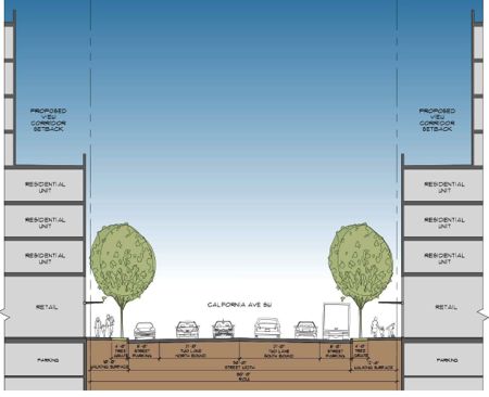
He pointed out the fact that California through The Junction is largely zoned for 85-foot high buildings, as a result of the last neighborhood-planning process a decade ago. If it is “built out” that way, with maximum lot use, this sketch shows what that would look like:

To soften the potential “canyon” effect, Nicholson said, they are proposing a “view corridor” a few stories off the street, to require that the upper floors of future buildings be set back. Some areas, such as Belltown, have that already, he said. Here’s what that would look like along California:
In order to require that “view corridor,” City Council approval would be needed. While councilmembers were noncommittal during today’s meeting, a few were reasonably enthusiastic; Rasmussen suggested, “I think community will accept the height if done with (good) design and the type of setbacks you are discussing.” He also wondered aloud how they might find a way to preserve some of the most notable historic storefronts without preventing property owners from developing the sites as the law allows.
Councilmember Sally Clark, who has visited West Seattle at least twice in recent months for walking tours (one of which we covered here), wondered if perhaps some way could be found “to save the buildings and transfer the development potential someplace else.” She chairs the council’s Planning, Land Use, and Neighborhoods Committee.
On the street level of California right now, Nicholson said, there’s one change they’d like to make that would not require much bureaucracy – tree grates to expand the amount of “walking surface” adjacent to the relatively narrow (six-foot) sidewalks. You’ve probably seen them somewhere else – the metal grate with a cutout for the tree, which still allows water to get to the roots. The existing “tree wells” are usually in the 4×6 vicinity, he said, so that would be a notable improvement.
From California, he moved to SW Alaska, noting that several major developments already are in progress or on the drawing board, so some of the proposed changes could be made as those developments are built. They’re hoping for “consistency in (such things as) street trees, light fixtures, amenities” and are continuing discussions with developers; one major suggestion is for “dedicated bicycle lanes” along Alaska: “If there is any street in West Seattle that needs a dedicated bike lane, it’s West Seattle,” Nicholson declared. Here’s a cross-section of what that might look like, pointed eastward from 42nd/Alaska, between the under-construction Capco Plaza and Jefferson Square:
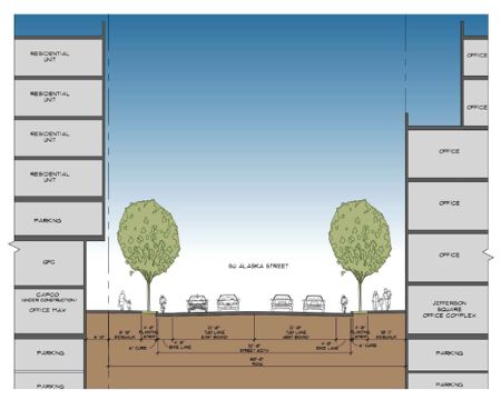
The Junction group says Alaska must become more pedestrian-friendly, as it’s likely to be the main route used by thousands of new residents to get from Triangle-area buildings to businesses in The Junction.
Next street they looked at, Fauntleroy. That included the overview at the start of this article – with a treed median dividing the road, to accomplish purposes from softening the “canyon” effect of development to better melding its evolving residential/commercial dual nature. Here’s a street-level rendering:
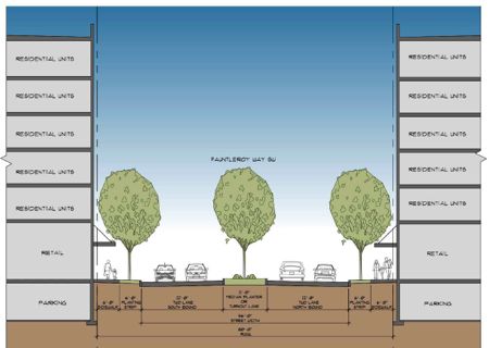
If you’re still having trouble visualizing it, they say the resulting “boulevard” would look something like this section of Lake City Way:

The Fauntleroy vision would require city money, the Junction group says, because of its scale/scope. How everything else might be achieved, it’s still too soon to tell. Nicholson noted, “We’re at the very beginning … What we’re trying to do is start the discussion. It would be unfortunate if all these new neighbors moved in, and the gateway to the area was just a bunch of concrete.”
WHAT’S NEXT: Lots of talking, and hopefully some action on both sides. Council President Richard Conlin acknowledged, “This does seem like a tremendous opportunity for the city so I’m hopeful we’ll be able to move this forward … This seems like a poster child for what a neighborhood planning process should involve.” Rasmussen said he wants to have city agencies closely involved, because “the sooner we get some agreement, planning, and guidelines enacted, everyone can work within them.” West Seattle Chamber of Commerce executive director Patti Mullen reminded those involved in today’s discussion that “broader community outreach” will be imperative “as these plans move forward”; that was echoed by Sharonn Meeks of the Fairmount Community Association — which she outlined as “the hillside that overlooks the Triangle area, about 267 homes” — saying, “We want to make sure the smaller residential neighborhood associations are engaged with the planning process as soon as possible.” She also noted that her group is working on a major meeting within the next couple months, but overall she notes, “We’re looking forward to redevelopment of an area that’s been a blight in the 28 years I’ve lived there.”
| 9 COMMENTS