West Seattle, Washington
12 Tuesday

(WSB photos by Christopher Boffoli)
Seen in The Junction today – but not what it seems. WSB’s Christopher Boffoli happened onto Seattle Police training in the 4500 block of 41st SW in The Junction.

The house at which they’re training is destined for teardown as part of the future Quail Park memory-care facility.

The project isn’t on the brink of construction – it has at least one more Southwest Design Review Board meeting to go, and that’s set for August 6th. In the meantime, you can expect to see police there again tomorrow.

(Video of entire meeting, unedited, added 2:58 am Thursday)
FIRST REPORT, 6:03 PM: At 7 pm, SDOT leaders and Mayor Murray will be at Neighborhood House’s High Point Center to announce the plan for 35th Avenue SW. According to the slide deck that’s already live online, here’s what they’ll announce:
It’s a two-phase plan, rechannelizing 35th this fall between Roxbury and Willow, with one lane each way and a center turn lane. The features of the first-phase Roxbury-to-Willow plan are shown and described as:

* More space for parking
• One lane in each direction
• Center turn lane
• Bus and turn lanes (BAT) at Barton, Thistle, Holden and Webster
• 30 mph speed limit
• Signal optimization
• Channelization improvements on SW Barton Street
• No changes on approaches to SW Roxbury Street
Then after an evaluation period, and “project information sessions” next spring, rechannelization between Morgan and Edmunds is planned for summer of next year. The slide deck also says no rechannelizing would be planned on 35th north of Edmunds, and that “repaving and new curb ramps” would be planned if the “Move Seattle” transportation levy passes.
Again, this is all according to the slide deck just posted on the project page in advance of the meeting (which is what SDOT usually does) – also posted is a public-comment log regarding the project; come to the 7 pm meeting (or tomorrow’s 6 pm edition at Southwest Library) for full details plus Q/A – we’ll be updating live.
7:11 PM: After a brief introduction from project manager Jim Curtin, SDOT director Scott Kubly spoke briefly. Even before mentioning details of the plan, someone from the audience called out that they wanted to ask questions immediately.

(Some of the 60+ people at the meeting)
Kubly asked them to wait until some others had spoken. Councilmember Tom Rasmussen then took the microphone, mentioning how many years this has been in the works.

Mayor Murray then speaks, saying they’re trying to find a balance between doing what needs to be done, and listening to everyone.

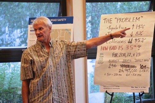
He refers to a stat you will see in the presentation deck – calling 35th SW the fourth-most-dangerous street in the city. “You’ve got my attention, trying to address these issues,” he says, also talking about having been hit by a car himself.
7:22 PM: Curtin is now presenting the slide deck, same one you see above. There’s a lot of backstory, much of which has been reviewed in the public meetings already held in relation to 35th. It includes a recap of the Vision Zero plan. Man in the front row looks at stats on screen and asks how many of the deaths on city streets are because of drunk driving; Curtin says, in a given year, anywhere from a third to half. Subsequent slides include “recent speed studies” – the average speed has come down a bit in recent years from 42 mph on average (7 mph above the speed limit). A bit of point/counterpoint breaks out in the crowd on that topic (if you’re not here, you’ll hear it in our video later, as we are recording the meeting). Curtin mentions 15 pedestrians have been hit on 35th in the past few years; a woman interjects, “How many were in crosswalks?” Shortly thereafter, Curtin mentions the five deaths on 35th in the past decade (actually in less than nine years).
New traffic data shows that vehicle volume has gone up a bit in the past two years – from 16,500 at Roxbury in 2013 to 16,37 now, 24,600 in 2013 at Alaska to 24,631 now. As Curtin starts to go through this, someone starts to ask questions, and Councilmember Rasmussen comes back to the front of the room (he and others including Mayor Murray went to the back after their initial remarks) to ask people to please wait for the Q/A period so everyone could hear the presentation. That’s greeted with applause.
Next, pedestrian volumes – they counted 15 locations at peak and midday periods; 313 in the morning, 239 at noontime, 561 at PM peak.
Showing again the stats – 1,065 total collisions in the past decade, 412 injuries, 5 fatalities – Curtin says, “if this were a disease, we’d be clamoring that something be done about it.” Four of the five fatalities in the past 10 years were pedestrians or bicyclists, says Curtin, while also noting: “These are your neighbors.” Most-common type of crashes, rear-end, followed by angles, followed by left turns, followed by parked cars, followed by sideswipes. (Again, you can see all this in the slide deck embedded and linked above.) The collision rate, acknowledges Curtin, is slightly below the citywide rate. But for deaths, he says, it’s higher.
7:39 PM: The Seattle Neighborhood Greenways-initiated safety petition, launched after the death of pedestrian James St. Clair in 2013, has just been presented to the mayor here in the room. Now Curtin has brought up proprietors of The Westy and Locol, after saying the business owners in the 35th/Kenyon node had made a compelling case for safety improvements. (Not that many years ago, the city removed a crosswalk there.)
From The Westy and Locol at 35th/Kenyon, proprietors say they want safety improvements pic.twitter.com/7PW5isOqR4
— West Seattle Blog (@westseattleblog) July 16, 2015
JP from The Westy said, “I don’t want to see somebody die there.” After complimenting them on enlivening the corridor, Curtin gets closer to unveiling the plan.
7:49 PM: He finally brings out the Roxbury-to-Willow first-phase rechannelization plan. No gasps, no boos, in case you were wondering. No reaction in general; people continue to listen. He says signals will be optimized along the entire corridor. Note that the speed limit will drop to 30 mph only as far north as Willow, this year. The Roxbury/35th intersection “functions really well,” so that is not being changed. Then in 2016, “We are going to evaluate what we do this year … we are going to launch a neighborhood greenway study (too).” He mentions the big new development planned at 35th/Graham (vicinity of two of the deaths in the past nine years) and that it will be starting next year. “There are a few unknowns on the north end of the corridor that we need to wait until 2016 to see what’s happening there.” SW Morgan will be rechannelized, he mentions, calling it “a longstanding request from the community,” saying it will get “the Barton treatment.”
He reiterates that no changes are proposed, this year OR next, for the busiest part of 35th, north of Edmunds. And he mentions plans for increased enforcement, which does draw applause. He’s summarizing: “We know this will improve safety” and brings up stats of other rechannelizations again, including Fauntleroy Way SW. “You didn’t change the speed limit,” an attendee calls out. Curtin acknowledges that, while going on to note that Fauntleroy has 31 percent fewer collisions now, has dropped the percentage of 10 mph+ speeders by 13 percent, and that volume change is up a third of a percent.
“If things are going well in the spring, we’ll look at implementing phase two next year,” Curtin summarizes, and now it’s on to Q/A.
8 PM: First question – “Monday, the mayor came out with his housing plan. All of 35th has been upzoned from single-family residences … Today I drove 35th … You’re predicating on everyone doing 30 mph … You’re going to have people doing 20 mph … that’s going to screw up your delays,” which SDOT says will max out at 2.5 minutes. The mayor came back to front of the room as soon as his name was mentioned, but the questioner has rambled on to say, “You’re increasing the population of West Seattle, increasing density, I don’t know how you’re going to make room for all the cars that people are going to own.” Applause follows. “There’s no correlation between increasing population and increasing traffic volumes,” Curtin says, and laughter breaks out. Now the mayor speaks. He says that only multifamily zones are being upzoned, “with an additional floor … Let’s deal with facts. Also, that’s my proposal. The council deals with (it from here).”
Curtin elaborates that though population is going up, traffic volume is going down. Next, Bob Neel, who started a petition against 35th SW rechannelization, says his petition had 916 signatures and the “pro-safety … and who’s against safety?” petition had 864.
He now asks for a show of hands about who signed which petition. (Both were on change.org.)
Next questioner says he was pessimistic pre-meeting but is “OK” with what he’s seen so far. But he also goes on to say he used to be an avid bicycle rider and he is concerned about more bicycle facilities than riders in Seattle. Curtin points out that this design does NOT include bicycle facilities.

(L-R, neighborhood advocates Mat McBride, Amanda Kay Helmick, Joe Szilagyi)
After him, Mat McBride, chair of the Delridge District Council, says most of the critics of projects like these are speaking from fear and uncertainty – and the fears haven’t come true. “I want to thank you all in dealing with the problems of what we have today, and not with the fear of what might happen.” Applause follows.
Q/A continues. A woman says she has lived on 35th for 41 years, “I’ve seen a lot of changes – some of them I don’t like.” She goes on to say that she is concerned about “crappy” pavement, particularly at Barton and Holden.
Another exchange involves someone trying to blame pedestrians and bicycle riders who “break the rules” for injuries/deaths. Drivers break the rules too, Curtin interjects, and while he agrees everyone needs to follow the rules, he notes that drivers breaking the rules have far higher consequences in causing injuries/deaths because of what they’re driving.
What about emergency vehicles getting around? one attendee asks. City traffic engineer Dongho Chang fields that question and says among other things the vehicles can use the center turn lane and also can trigger signals to change.
Another 35th SW resident talks about problems she’s seen over the years; she wonders why the “speed detector” at Brandon/35th “was removed,” saying there’s a speed problem near her home and can the detector come back? It is coming back, Curtin says; that draws applause.
Kenyon, Dawson, Brandon, Juneau are places where people want new crosswalks, Curtin says shortly thereafter, in response to an inquiry about improving crossing safety. He mentions the new flashing-beacon signs at California/Dakota and on Holden and says they seem to be helping and might be an option.
Next person says he’s excited about the turn lane and about “parking expansion.”
(We’ve lost some of the back and forth here but it’ll be in our video.) In response to another question, Chang takes the mike and says people are adaptive, and that a reduction in collisions is “huge. … Long term for us, what we want to do in the corridor, is have people get through safely …” He addresses the population increase and traffic decrease, with “transit … carrying the bulk of our growth.” Chang adds, “we’re going to be watching (the 35th) corridor every day. You live here. You know how things are functioning. Let us know. We can make changes very quickly.” An attendee asks, why not keep the 35 mph speed limit? Chang refers to the stats about the survivability of what speed people are hit at. “I now understand the consequences of each decision … We’ll do followup studies and make sure the corridor is functioning.”
Curtin, moving toward wrapping up, says San Francisco is “moving toward this treatment for one of its busiest corridors, 45,000 vehicles daily.” Someone calls out, “They have mass transit.” Curtin says that 35th *has* mass transit, noting that he travels it daily (he’s an Arbor Heights resident).
8:45 PM: The presentation is over; dozens are still here to ask questions in small groups or one on one. We’re going to go try to get a clarification or two ourselves, and will add anything more we find out. Meantime, if you missed this, there’s another presentation at 6 pm tomorrow (Thursday) at Southwest Library – bring your questions/concerns there – and/or e-mail project manager jim.curtin@seattle.gov any time.
9:29 PM: A question came up in comments about crosswalks. Post-meeting, we talked with Chang, who said that crosswalks will follow rechannelization – they’re not installing anything more on the four-lane road, but after assessing how the three-lane version is going, he says they might wind up installing “many” crosswalks.
ORIGINAL REPORT, 4:38 PM: On Tuesday afternoon, southbound traffic on Fauntleroy Way backed up as if it were a weekend, and the Fauntleroy-Vashon-Southworth ferries are running behind again today, so here’s an alert just in case it happens again: Most of it is because a repair project has resulted in single-lane loading at the Vashon Island terminal. The Fauntleroy Community Association board notes that this weekend might be even more intense with both the Vashon Strawberry Festival and Saturday’s reopening of Cove Park. They were planning to ask SPD for traffic-management help, “including creating the center turn lane as a southbound vehicle lane where backed-up traffic must sit in the roadway as it passes parked cars on the curb” and also noted that Vashon ferry users had requested weekday afternoon parking restrictions along Fauntleroy Way. We’ll be checking for the status of those requests, but in the meantime, keep in mind that southbound Fauntleroy between Morgan Junction and the ferry dock might be worth avoiding if you can. You can check dock-area webcams here.
5:31 PM UPDATE: WSF has just announced that because two of its larger boats will be out next Monday through Wednesday, it will shuffle boats and schedules on those dates, including Fauntleroy-Vashon-Southworth. So July 20-22, the “triangle route” will be on a two-boat schedule, with M/V Issaquah and Cathlamet supplemented by the 34-vehicle Hiyu.

2:29 PM: If you’re seeing smoke from a distance – it’s a brush fire in High Point, near the pond, on a grassy slope.

Firefighters are here and taking care of it but the smoke was visible from a couple miles away. More to come.

2:38 PM: Engine 36 is the crew on scene and the flames are out, the smoke has dissipated, but they’re soaking the charred slope in a big way – as neighbors are observing, it’s really dry here, even just over the green embankments by the pond itself. This was stopped before it could spread to any buildings, and no injuries are reported. No info yet about how it started.

10:01 PM: Still awaiting the cause info but we do know that it burned a quarter of an acre and came perilously close to a fence. SFD planned to check back at the scene tonight to be sure no hotspots remained.
Maybe somebody in your family – or your neighborhood – could use this service this summer:
This summer, hundreds of sites across Washington State are providing free meals for kids and teens! Places like local high schools, elementary schools, community centers, parks and apartment complexes, will serve breakfast, lunch and snacks for kids under the age of 18. It is open to everyone!
There is no enrollment or registration is necessary. Meal times, and days of the week will vary among sites, along with the actual meals served. To find a Summer Meals site near you: Call 1-888-4FOOD-WA, visit parenthelp123.org or Text MEALS to 96859.
Listed below are some Summer Meals sites in the West Seattle neighborhood:
West Seattle Elementary
Through 7/31/15
M, T, W, TH, F
Breakfast: 8:30AM-8:55AM
Lunch: 12:00PM-12:25PMHigh Point Community Center
Through 8/22/15
M, T, W, TH, F
Breakfast: 8:30AM-9:30AM
Lunch: 12:00PM-1:00PMSanislo Elementary
8/17/15-8/21/15
M, T, W, TH, F
Breakfast: 8:30AM – 8:50AM
Lunch: 11:45AM – 12:15PME.C. Hughes Playground
Through 8/21/15
M, T, W, TH, F
Lunch: 12:00PM- 1:00PM
Snack: 3:00PM-3:30PM

(Photo and video by Laura James)
It’s beautiful – and sad. Protecting her eggs until they hatch is the last thing this Giant Pacific Octopus will ever do. But it’s an amazing sight to see, and “Diver Laura” James plans to check back on this one, in hopes of catching the hatching when it happens (she’s recorded the process before – see the end of this story). This octopus and her eggs are at Cove 2 near Seacrest off the West Seattle shore. Here’s the video version:
GPOs usually lay thousands of eggs. The survival rate is infinitesimal.
P.S. You can help this octopus, her future babies, and the rest of Puget Sound sea life (ultimately benefiting those of us on shore, too) by following the simple advice here.
Something to say about crime concerns and Seattle Police‘s work in your neighborhood?
Starting one week from tonight, a Seattle University research assistant who has been working for months with Southwest Precinct police is holding community meetings to hear from you.
Jennifer Burbridge has set a schedule of focus-group-style meetings in which she is extending an open invitation for community members to show up and talk about crime and police issues, particularly (but not exclusively) as they relate to the “micro-community policing plans” announced earlier this year. She explains:
The structure of the focus groups is that I will pose a series of questions about crime concerns, the micro-community policing plans in each area, how the community feels the police are addressing their concerns, and how the community feels the police can improve in their efforts. So I am looking for both specific concerns as well as generalities about how the community is feeling about the micro-community policing plans.
Burbridge says the community members who participate will not be identified by name. Here’s the schedule – ALL meetings will be in the community room at the Southwest Precinct:
-Wednesday, July 22nd: ALKI COMMUNITY, 6-7 pm
-Thursday, July 23rd: ADMIRAL COMMUNITY, 6:30-7:30 pm
-Tuesday, July 28th: WS BLOCK WATCH CAPTAINS NETWORK, 6:30-7:30 pm
-Thursday, July 30th: WESTWOOD/ROXHILL/ARBOR HEIGHTS COMMUNITIES, 6:30-7:30 pm
-Wednesday, August 5th: PIGEON POINT COMMUNITY, 6:30-7:30 pm
-Thursday, August 6th: HIGH POINT/ALASKA JUNCTION COMMUNITIES, 6-7 pm
-Tuesday, August 11th: MORGAN JUNCTION, 7-8 pm
-Wednesday, August 12th: DELRIDGE COMMUNITY, 6-7 pm
The precinct is at Delridge/Webster; the community meeting room is right off the parking lot, which in turn is off Webster.
P.S. If you aren’t familiar with the micro-community policing plans – six are linked here. But again, that familiarity is not a prerequisite – if you have something to say about crime/policing, your participation is a plus. Burbridge already has been immersed in this work for months – we’ve seen her at many community meetings – and this is the next step.

(American Goldfinch – the Washington state bird! – photographed at Fauntleroy Park by Mark Wangerin)
Happy Wednesday! From the WSB West Seattle Event Calendar:
LOW TIDE: Today’s low-low tide is again out to -1.8 feet, at 11:06 am, and you’ll find Seattle Aquarium volunteer beach naturalists at Constellation and Lincoln Parks 10 am-12:45 pm.
JAMTOWN HOWDY BAND: Your 3- to 8-year-old can be in the band – just show up at Delridge Library, 11:15 am-12:15 pm, as explained here. (5423 Delridge Way SW)
COWORKING MEETUP: Noon at West Seattle Office Junction (WSB sponsor), our area’s only coworking center. Even if you love solopreneurial work, telecommuting work, whatever form of nontraditional work you’re doing, get on out for a bit and swap ideas, inspiration, and stories. (6040 California SW)
COLLEGE PREP WORKSHOP: 4-5 pm at High Point Community Center, free workshop for youth looking ahead to the college-application process, as explained here. (6920 34th SW)
HIGH POINT MARKET GARDEN FARMSTAND: Also in HP, 4-7 pm, the weekly chance to buy organic produce within view of where it was grown! (32nd/Juneau)
CANDIDATES’ FORUM: 5:30 pm at South Seattle College (WSB sponsor)’s Brockey Center, your last chance for side-by-side comparisons of the District 1 City Council candidates before ballots start arriving, co-presented with the West Seattle Chamber of Commerce, focusing on questions about business, jobs, and education. (6000 16th SW)
RUN WITH WEST SEATTLE RUNNER: 6:15 pm, meet at West Seattle Runner (WSB sponsor) for a 3- or 6-mile run – details here. Free! (2743 California SW)
35TH SW PLAN: 7 pm at Neighborhood House’s High Point Center, be among the first to find out what SDOT is proposing to improve safety on 35th Avenue SW. (6400 Sylvan Way)
MORGAN COMMUNITY ASSOCIATION: 7 pm at The Kenney (WSB sponsor), be there for another infopacked quarterly MoCA meeting – here’s our preview with the agenda. (7125 Fauntleroy Way SW)
DELRIDGE GROCERY COOPERATIVE: Got ideas to get the word out about the “Delridge food revolution”? Come to Delridge Grocery Coop‘s public forum tonight, 6:30 pm, at Southwest Youth and Family Services. (4555 Delridge Way SW)
COMEDY NIGHT: Laugh It Off! with a big slate of comics at Feedback Lounge, 8 pm. (6451 California SW)
JUBILEE DAYS FIREWORKS: At dusk, a big professional fireworks show from Steve Cox Memorial Park kicks off the White Center Jubilee Days festival. Even if you’re not going, you might hear it from here. (14th SW/SW 102nd)

On the east lawn at Hiawatha Community Center last night, they sat on the lawn and soaked up the sound of the West Seattle Big Band during this year’s Hi-Yu Concert in the Park – here’s a two-song section of the show:
Midway through, it was time for a special presentation – the band’s former longtime director Donn Weaver was honored with the Orville Rummel Trophy for Outstanding Community Service in advance of this Saturday’s West Seattle Grand Parade:
Find out more about Weaver and the Orville Rummel Trophy in our Tuesday story.

He was presented with the trophy in view of neighboring West Seattle High School, where he taught music for decades, with students including his successor as WS Big Band director, Jim Edwards:

Edwards is also a co-coordinator of the parade, in which Weaver will ride toward the start with the trophy; the parade is this Saturday (July 18th), leaving California/Lander in The Admiral District around 11 am, headed southbound to California/Edmunds in The Junction. Meantime, after the presentation, the band played on:

And on the sidelines, a couple danced:

The Big Band’s main mission is to raise money for school music programs. You can track the band’s public gigs via its online calendar – next up, the Ballard Locks this Sunday (July 19th) at 2 pm.


(Four WS-relevant views; more cams on the WSB Traffic page)
7:23 AM: No incidents in or from West Seattle so far this morning. If you’re using the Fauntleroy ferry dock, note that the north tollbooth will be closed 7:30 am-2 pm today, as the adjacent Barton Pump Station Upgrade Project wraps up – 2 pm celebration this Saturday, including the reopening of Cove Park north of the dock.
ALSO ON SATURDAY: California SW will close from The Admiral District to The Junction for the West Seattle Grand Parade, preceded by the Float Dodger 5K, reopening when the parade ends in early afternoon. Watch for no-parking signs on side streets that will be used for staging and for Metro rerouting (now posted on the Metro website); parade organizers advise paying close attention to what’s on the signs, as parking restrictions and reroutes will start earlier this year.
Meantime, big transportation news is hours away:
35TH SW PLAN: 7 pm at Neighborhood House’s High Point Center (6400 Sylvan Way), SDOT’s plan for 35th SW goes public. We’re told the mayor will be there. If you can’t make it to tonight’s meeting, a second one has been scheduled for tomorrow, 6 pm, at Southwest Library (35th/Henderson).
7:48 AM: If you’re headed northbound from south of the West Seattle Bridge, two problems right now – a crash blocking one lane on NB Highway 99 at Cloverdale, and a crash reported at 4th and Michigan (no specifics).
10:05 AM: Another NB 99 crash south of here – this time at West Marginal Way. Police are en route.
10:35 AM: Heads up for possible Fauntleroy Way southbound backups again this afternoon. Washington State Ferries says one of the conditions that factored into them is continuing today: “Due to emergent dock repairs at the Vashon terminal, single-lane loading and offloading will continue until further notice. Drivers and passengers can expect delays and are advised to plan accordingly.”

Thanks to Mark Ahlness of Friends of Lincoln Park for the photo of one of two new signs installed at the park, “part of an effort to raise awareness that the forest floor is alive, that the habitat (home to many creatures and essential to our well being) is in the process of being restored by Friends of Lincoln Park volunteers, and that it needs protection and ongoing maintenance.” He says FLP worked with the Seattle Nature Alliance, whose initial membership drive funded the signs, installed by Seattle Parks, as were two similar signs placed in Schmitz Preserve Park last September. (For more on why staying on the trails matters, see this story we reported and published last March, about a student researcher’s work with FLP on the issue.)
| 3 COMMENTS