
West Seattle, Washington
21 Friday

Look what showed up for NASA Solar System Ambassador Alice Enevoldsen‘s quarterly solstice/equinox sunset watch in West Seattle – the sun! Two hours earlier, Alice tweeted at us regarding the sudden sun sighting:
Winter solstice in Seattle, and I just had to put on my sunglasses. WHAT??! @westseattleblog
— Alice Enevoldsen (@AlicesAstroInfo) December 21, 2012
While the gatherings are mostly a chance to find out more about the solar-system phenomena from a volunteer expert, actually seeing the sun means a chance to check the alignment of Solstice Park‘s special features. Here are some of the 30 or so sunset-watchers who showed up:

Checking our archives, it seems the sun appeared for last year’s winter-solstice-sunset event, too. This year, Alice had something extra to explain:

In recent months, she became an expert 2012-end-of-world debunker (see her various links/explanations here), so there was an extra note of triumph in the simple fact that tonight’s event did happen as scheduled. (P.S. The solstice moment itself was 3:12 am today. Next up – spring equinox, 4:02 am our time March 20, 2013. Watch for Alice’s event announcement when it gets closer – it’ll be on her website, along with other interesting astronomical updates, at alicesastroinfo.com.)
FIRST REPORT, 3:54 AM: Though the maps showed Seattle in the “snow shadow” again, snow is falling right now here in Upper Fauntleroy. Just one of the showers mentioned in the forecast? Just went out to check, and it’s fairly wet snow – sticking to the cars, but also audibly melting in the downspout. (Video added above, 4:09 am.) Let us know if you’re seeing any where you are.

4:24 AM UPDATE: It switched to freezing rain after a few minutes – but now flakes are mixed in again – seems to be right in line with the “rain/snow showers” forecast. Photo shows what that first wave left on the car window.

5:04 AM UPDATE: Another serious snow shower’s been under way awhile – more on the car, but not on the road so far. Added the bridge cam view just in case. (You can see more West Seattle and WS-relevant cams here.)
6:55 AM UPDATE: No major problems or changes related to the snow showers.
9:35 AM UPDATE: The winter-weather advisory for the area will expire at 10 am, and the latest forecast says that by afternoon, precipitation will be all rain.

(1st three photos from Monday, by Nick Adams for WSB)
By Tracy Record
West Seattle Blog editor
We have just learned that yesterday morning’s highest water level – the combination of high tide and “storm surge” – wasn’t just high, it was historic – the highest level ever recorded in Seattle.
The word comes from Seattle Public Utilities, which has to track this closely because of the effects storms and high tides can and do have on their facilities – look closely to see the water coming OUT of this manhole on Beach Drive, instead of going in:

And SPU meteorologist James Rufo-Hill tells WSB it’s likely “a harbinger of things to come.” More from our interview, ahead:
The King County Wastewater Treatment District says the Monday morning “storm surge” caused some minor damage at the Barton Pump Station expansion project north of the ferry dock. Crews repaired the chain-link fence and concrete barrier blocks, according to a news release:
The storm washed waves and driftwood through the barrier into the construction site. The repaired barrier includes an additional row of concrete blocks to protect against future storm events.
Crew members were on site Sunday to prepare for the approaching storm. All on-site liquids were properly stored and materials from the jet grouting operation were cured. There was no contamination of any materials into Puget Sound.
Crews will continue to monitor site conditions through the winter storm season and will take precautionary measures as needed to protect both the site and Puget Sound.
The construction work is scheduled to continue until late 2014.
1:49 AM: First snow sightings – Westwood, Sunrise Heights, Highland Park. Forecast still does not suggest anything major, though.
6:12 AM: Nothing on the ground where we are. And Seattle is still in the (small) “snow shadow” zone on the National Weather Service map you can see here – meaning no alerts/advisories/warnings right now.

(Photos by Nick Adams for WSB)
Anyone seen a dock? After the big-surf day on Beach Drive, Kathleen is missing one from the 5400 block. She says: “I’m certain we are not the only ones, but if you end up with an unfamiliar dock on or near your beach, please post a pic or give me a call at 206-734-5992.”
That’s just one of today’s many storm stories. We covered the high wind, high waves, and high tide as it all unfolded this morning – see our morning coverage here for as-it-happened video and photos – but tonight, we have one more look at a day that won’t soon be forgotten. WSB contributing photojournalist Nick Adams captured the fierce beauty …

… and the hard work:

That’s Rhonda Porter and son Taylor carrying water-pump hoses to a neighbor’s home. It was a day for neighbors helping neighbors, and for the Seattle Fire Department to be called in here and there:

The water caused some electrical trouble here and there.

Eight more photos ahead:

(The Olympics seen Monday morning from Beach Drive, by Nick Adams for WSB)
The mountains today – your place tomorrow? Here’s the latest on whether we might see some snow early Tuesday morning (and beyond). The newest forecast includes the possibility of rain/snow showers after midnight – and pegs the snow level at 400 feet (West Seattle’s highest spot is 512′ by Myrtle Reservoir); the chance of snow showers continues throughout the day, but the snow level is expected to rise to 500 feet in the afternoon.
Weather analyst Cliff Mass just published a late-afternoon update, and says he does not think the lowlands will see much if any – he believes the city will be in a snow shadow. But, as with this morning’s wind, waves, and high tide, we’ll be tracking the weather again overnight and into tomorrow, so stay tuned.
(EARLIER COVERAGE: Our as-it-happened morning storm coverage with video and photos is here)

With all of West Seattle’s west/northwest-facing shoreline getting pounded by this morning’s high-tide/high-wind double-punch, and Lincoln Park has suffered some damage, shown in photos by Trileigh Tucker:

That hole in the top of the seawall was being checked out by Seattle Parks workers while Trileigh was there:

Parks’ media liaison Dewey Potter is checking for us to find out if any damage has been officially tallied in local parks so far. Meantime, Scott Bessho also shared photographs from the north side of Lincoln Park:

That was the most striking view – debris all over the north end of the waterfront trail, just before the park makes way for the south end of residential Beach Drive. We’ll add any information we get later about park damage. we also have another set of photos coming up that shows how it went at Constellation Park – this area’s most-popular wave-watching spot – this morning.
(SCROLL DOWN for the newest photos/video)
(Added 8:44 am – high tide swamping Statue of Liberty Plaza)
ORIGINAL 6:06 AM REPORT: So far, no major damage or outages reported in West Seattle in the four and a half hours since the wind started kicking up. We’re starting this new report to track whatever happens – including our usual traffic watch – during the morning commute and beyond.
(The west-facing bridge camera is back! Other cams are on the WSB Traffic page)
VASHON WATER TAXI CANCELED: King County just sent a text alert that the Vashon-Downtown Seattle Water Taxi is canceled TFN because of the wind. There are **no** changes reported to the West Seattle Water Taxi so far, though.
HIGH WIND WARNING: The National Weather Service’s wind advisory has been upgraded to a high-wind warning, in effect till noon. See it here; it mentions sustained wind out of the SW, 25-35 mph with gusts of 60 mph possible until midday, though it’ll still be breezy then, with gusts of up to 40 mph.
SNOW TONIGHT/TOMORROW? We mentioned it on Sunday – and the possibility of snow after midnight is still in the newest forecast.
7:06 AM UPDATE: In our area, two single-customer outages are now listed on the City Light map, one in North Admiral and one in Shorewood, both with “tree” listed as the cause. The ground saturation from recent rain has increased the tree/slide risk. On the WSB Facebook page, KL reminds us that since many in West Seattle have Monday trash pickup, you’ll want to take extra steps to secure your containers since the wind will be gusty for at least a few more hours. Also note that this morning’s high “king tide” – almost 13 feet – is still more than an hour away; (added) Justin took this predawn video from Alki and 53rd around 6:30 – no beach visible:
Further west, Beach Drive Blog is tracking it, including video updates.
7:26 AM: Potential traffic trouble – 3-vehicle crash at Delridge/Genesee. Emergency responders en route.
7:51 AM: Waiting to hear from our crew at that scene. Meantime, now that it’s becoming light, we’re seeing what the mega-high tide looks like – Lise Thivierge just sent this from Seacrest:

Seattle Fire has been dispatched to a home in the 6700 block of Beach Drive reporting water coming into the house.
8:05 AM: Just got this video from Mark Tabbutt near Lowman Beach:
8:29 AM: And from Margot in the 7100 block of Beach Drive – she says this is her “front yard”:

We’ve been to Statue of Liberty Plaza, where water has swamped onto the plaza itself. Photo (also see video added atop this story):

8:41 AM: Mark near Lowman Beach also sent this photo of high water at his neighbors’ house:

And back on the north side of the West Seattle waterfront – the tide, without the strongest wind gusts, is swamping Don Armeni – Carolyn Newman sent this photo:

8:55 AM: Swamped stairway and boardwalk at Alki at highest tide half an hour ago:

A reader texted this photo from near Constellation Park (south of Alki Point):

Thanks to everyone who has shared photos – we have two crews out and will be adding more of their photos too, but your perspective from waterfront homes is unique and appreciated. Hope no one has suffered serious damage.
9:24 AM: Thom, just south of Lowman Beach, shared this video:
He added, “Since that video was taken, the other half of the gate is gone as well as the splash plank.”
10:19 AM: Further north on Beach Drive, in the 5400 block and vicinity, WSB’s Patrick Sand caught the waves and the driftwood logs looming offshore:
Thanks to Lura for letting us come shoot that view. Not far away, at Beach Drive Blog HQ, where they were busy getting word out about all this days ago, Patrick’s video shows them pumping out the water that came in:
(added) Kim sent this view of the waves along the 3800 block of Beach Drive:
We also have photos of tree trouble in Highland Park:

Nora, who shared the photo, says: “Fortunately one car is in the shop otherwise it would have been under the big branch to the left. Damage to carport with a few branches sticking through the roof. No damage to the car beneath.”
11:44 AM: We went to the Alki Bathhouse to make sure the high water hadn’t gotten inside and done damage – it had not, we’re told. But while there, we caught this only-on-a-high-tide sight:

We have LOTS more photos to publish – will update when we either add them here or launch a new story.
(Short clip of what it sounded like around 2 am – just in case you sleep through the whole thing)
1:57 AM: In the past 20 minutes or so, the wind has arrived in a big way where we are, west-facing Upper Fauntleroy. The forecast remains the same – the National Weather Service has our area under a wind advisory until 4 pm today. If the NWS keeps to its usual timetable, the next likely forecast update will be within the next two hours or so. We’ll be monitoring everything throughout the morning – here’s hoping for no major trouble, but if there’s a power problem, a downed tree, etc., where you are, please let us know (text or call 206-293-6302).
2:25 AM: Some links we’re watching:
**City Light power-outage map (none as of this writing)
**Hourly readings at weather stations (the T column is temperature, SP is wind speed, GS is wind gusts)
**Seattle City Light’s “Wind Watch” animated forecasting

(Added 6:38 pm: Rainy Junction evening; photo by Nick Adams for WSB)
3:31 PM: What was a National Weather Service high-wind watch for our area is now a wind advisory, 10 pm tonight till 4 pm tomorrow – see it here. We’ll be updating throughout the night/morning. There’s also a “coastal flood advisory” for “minor tidal overflow” in waterfront areas 7 am-11 am tomorrow, since the wind will coincide with a very high tide (12.9 feet, 8:17 am Monday). And then, the forecast for Monday night and Tuesday DOES suggest some snow on the hills. However, as we’ve already noted via Facebook and Twitter – if you received a “blizzard warning” on your phone, that does NOT involve our area – just the mountains.
5:36 PM UPDATE: Seattle City Light has updated its Power Lines site to say it’s prepared in case of outages, with extra staff. And regarding that “blizzard warning,” KING5.com has the explanation.
Be sure you have batteries on hand, and check around your house for anything in danger of being picked up and blown around: The National Weather Service has renewed its High Wind Watch for our area – in effect late tomorrow night through Monday morning. See it here; the NWS says it’ll be southwest wind, “rising to 25 to 35 miles per hour, with gusts to 60 mph.” We’ll keep close watch on the changing forecast, as well as the wind itself if/when it arrives.
10:24 AM: Two weather notes this morning – First, just received a text (206-293-6302 any time) noting “lumpy rain” north of Roxbury. The National Weather Service did warn of “rain mixed with snow” in this morning’s forecast update – increasing winds, too, and we’ve seen them kick up here. The NWS also has a Special Weather Statement out for the region, including our area, about a big storm headed this way late Sunday and into Monday – wind and rain mentioned, not snow, though “snow showers” are noted as possible in the aforementioned forecast. P.S. Could be extra-problematic in waterfront areas if high wind coincides with the ongoing high tides – Beach Drive Blog has a mashup of all that info together.
4:57 PM UPDATE: The Special Weather Statement has since been upgraded to a High Wind Watch for late Sunday night into early Monday morning – see it here.

Thanks to early-rising WSB’ers for sharing photos of this morning’s short-lived sunbreak – which revealed the moon and the mountains, and high tide. Top photo is from JayDee in Upper Alki; next, from Leslie, on Beach Drive:

The water was so high over at Don Armeni, Carolyn Newman reports, launching a boat required extra wading:

And from Don Brubeck, a closer look at the snow-frosted Olympic Mountains in the early-morning light:

Thanks to everyone who shared photos – the sun’s long gone, at least for now!

Thanks to the WSB’er who shared the photo; after a night of pounding rain, a mudslide behind a building in the 1300 block of Alki Avenue SW is reported to have damaged three vehicles, pushing them into each other. We’ll be checking to find out more; the National Weather Service‘s newest forecast says showery, breezy weather will continue today. Any weather trouble where you are? Let us know – thanks!
The National Weather Service includes our area in an alert out tonight – a “coastal flood advisory,” for possible tidal overflow, especially during the high tides the next two mornings. At 6:08 tomorrow morning and 6:41 Friday morning, the high tide will be just under 12 feet – but a “tidal anomaly” may push the water a foot or two higher. So the NWS is alerting waterfront residents and anyone else who might be out on the shore.

A promise that the weather will improve? Forecast says that tonight and most of tomorrow should be calmer. Meantime, WSB’ers have shared views of the rainbow sighting this past half-hour or so – top photo is from Glenn Brooks. Next, from Lise Thivierge, a High Point view:
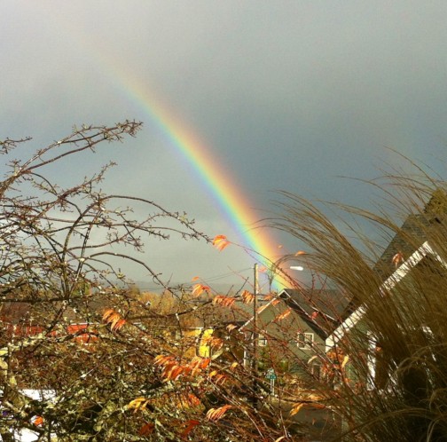
And from Willie Ellenberg via the WSB Facebook page, a double rainbow!

Thanks as always to everyone for sharing – editor@westseattleblog.com (or other contact channels) any time!
Just in from Seattle Ski Shuttle, which is operated by the same folks who bring you Mountain to Sound Outfitters and Alki Kayak Tours:
Crystal Mountain is officially opening on Wednesday, November 21, 2012. The Seattle Ski Shuttle will be running our first shuttle of the season that day. Also, starting Friday, November 23rd, we will be operating our regular schedule to Crystal Mountain (Mondays, Thursdays, & Fridays every week)! We will also be running a shuttle to Snoqualmie Central on weekends once the mountain opens up. For more information and to book a seat, go to: seattleskishuttle.com

Wild weather this afternoon! The photo was shared by Carlos H. via Twitter. And though there’s a band of blue sky advancing as we type, you should know we’re under a wind advisory till early evening, too, as the next front literally blows through. Local meteorologist Patrick K. points out that what you see in Carlos’s photo is a “squall line.” Latest forecast says rain/showers are expected to continue off and on all week. If you can, take advantage of the impending break in the rain to clear your nearest storm drain! It’s usually a quick job, since yours probably isn’t THIS imposing:

That’s the Longfellow Creek sluice gate at 25th and Juneau; Lauren has been telling us about it, and shared the above “before” photo, with leaves, sticks and logs cluttering it till cleared – not by city crews (though we’ve seen them out and about all day) but by her husband. If it gets clogged, there’s a risk of big flooding, Lauren explains.

Thanks to Jenn Padilla for sharing that photo from the Alki boardwalk, where high water from our record rainfall has augmented what was already one of the month’s highest tides, 12 feet, peaking about an hour ago. Jenn texted us the photo (206-293-6302 any time), saying she’d never “seen the Sound so full that it spilled over.” (The peak high tide was 12.6 feet last Saturday.) P.S. From just around the point to the south, here’s high-tide coverage on Beach Drive Blog.

(Photos by Nick Adams for WSB)
Our stormy day had two distinct phases – in the morning, it was all about the water, including the mini-lake in WSB contributing photojournalist Nick Adams‘ image from SW Barton Street. In the afternoon, it was all about the wind:

The tree-buried SUV was in Sunrise Heights, in the 7100 block of 32nd SW; head-on, it was almost completely out of sight.

Other toppled trees were featured in our afternoon coverage.
Tomorrow’s forecast: Rain at times, but mostly in the afternoon, so the morning commute, at least, shouldn’t resemble anything like today.
(Our morning storm coverage is here)

(Added 2:30 pm: Tree down in Junction; photo courtesy Marty Sweetman)
1:25 PM: We’re launching afternoon storm coverage now, with widespread reports of power flickers – we were in a Junction business where it flickered twice a few minutes ago, and the wind is gusty out of the south here too. More to come.

(Added 2:40 pm: Nickelsville resident JS, building a walkway; WSB photo by Nick Adams)
1:32 PM UPDATE: We’ve received a request for help from Nickelsville via intermediaries – they need gasoline to power generators to pump out floodwaters at the camp (West Marginal and Highland Park Way). If you can help, just take some down.
1:36 PM UPDATE: Serious wave action south of Alki Point, as is usual with wind out of the southwest. We checked on the flickers – there is NO larger outage anywhere, so far. Just widespread flickers. Just in case it does go out later, be sure you have what you need nearby – charge your phone, have batteries for whatever needs batteries, keep a flashlight handy, etc.
1:52 PM UPDATE: Just got back to WSB HQ in Upper Fauntleroy for the first time in an hour or so – we’re out of power here. City Light map says about 150 customers (homes/businesses).

(Added 2:30 pm: Tree down on 18th near Sanislo Elementary; photo courtesy Cary Swain Seely)
2:25 PM UPDATE: There is some good news – the rain stopped. For now. But there are scattered reports of trees down – saw one along Fauntleroy in Fairmount Springs; Kevin sent word of one in Endolyne; no major road blockages reported, though. (Update – see the photo added above from 18th SW – that may be causing trouble.) City Light, meantime, says it doesn’t know yet what’s to blame for the outage in Upper Fauntleroy/Gatewood.

(Added 2:40 pm: Tree down at 45th and Wildwood in Fauntleroy)
2:49 PM: Scott reports via Twitter that Admiral is closed between 58th and 59th because of a power pole that looks to be in danger of falling.
3:04 PM UPDATE: Cami says it’s actually closed at 57th. We’ll have a crew in the area shortly. Also via comments, Cait says Webster is closed in the Delridge vicinity. THANK YOU to everyone continuing to share information and photos.
3:14 PM UPDATE: Photojournalist Nick Adams, out on storm coverage for WSB today, is at 58th/Admiral with the power-pole problem and says traffic is now open again, one lane each way.

(added later) This photo courtesy of Don Brubeck shows the pole while it was leaning:

NEW traffic problem that might affect some people headed toward West Seattle – southbound Battery Street Tunnel is closed, apparently because of a crash, per SDOT.
3:37 PM UPDATE: City Light map shows the Gatewood/Upper Fauntleroy outage over – we’re working away from HQ right now so can’t verify. Couple other scattered, very small outages in spots around West Seattle. (Few minutes later) Battery Street Tunnel southbound now OPEN again, per WSDOT. Meantime, some bus reroutes out there – just got one from Metro re: Route 128 routed off 16th between Henderson and Cambridge.
4:23 PM UPDATE: No new problems reported lately. But still give yourself extra time to get home. Any break in the weather is just temporary, the forecasters say. And take note this is already the rainiest November 19th on record.
5:27 PM UPDATE: Got e-mail saying that the Admiral exit from the West Seattle Bridge has a major puddle/pond, so avoid if you can. Meantime, the rain comes and goes – raining hard again about 20 minutes ago, not so bad right now, but still lots of water everywhere. P.S. If you’re on a bus and have some time, here’s a new West Seattle-specific survey from Metro, explained and linked here.
(SCROLL DOWN for newest updates – we’re out checking on trouble spots too)

(Live view from the only WS Bridge camera currently in operation; see other cameras on the WSB Traffic page)
6:33 AM: Rain is the big challenge this morning – and deep water is causing trouble on at least two ramps, according to Twitter reports – Delridge to the bridge, and bridge to 99. Lots of water on the roads everywhere we’ve driven. We’re monitoring trouble spots as always.
6:54 AM: A commenter says the ramp from the bridge to I-5 is developing deep-water trouble too. And even if you’re just walking outside your home, beware – our crew just back from an early-morning fire scene found a parking strip with ankle-deep, shoe-filling water. An urban/small-stream flood advisory is in effect all day – into the evening commute – for the entire county, with the possibility of up to 2 inches of rain.
7:33 AM: More reports in comments about water woes around the peninsula – including Fauntleroy and Raymond, a perennial trouble spot, and 35th/Avalon. Our friends at KING 5, who have had crews roving, mentioned a 35th/Barton puddle too.
7:55 AM: From onboard a bus:
The #RapidRide I’m on is leaking from the roof.. @westseattleblog@kcmetrobus
— laurenlovesbecca (@_laurez_) November 19, 2012
8:24 AM: Out roving now. Delridge has many spots with serious puddling, including at Myrtle and just south of Webster. Mary just sent us a photo of someone working to clear out the ramp “lake” by the bridge:

8:39 AM: Another sign of a serious storm: The combined-sewer overflow at Barton (north of the Fauntleroy ferry) is discharging. You can check the CSO status in ‘real time’ on this county webpage. Around the area, efforts continue to reduce the need for those overflows by catching stormwater in other ways. We were reminded of that while just passing the stretch of 26th SW in North Delridge that is getting bioswales – not ready in time for this storm, but some of the holes are dug.

(Minutes later …) We’re checking Longfellow Creek by the Allstar Fitness lot, where water is spouting up from one manhole on the south side.
9:18 AM: Along Alki, some curbside overflow, and downtown is hard to see from Seacrest:

Along Alki and along Delridge (where the next photo was taken), we’re continuing to see people braving the rain to clear the storm drains and reduce puddling:

Seattle Public Utilities is responsible for the storm drains but can’t do it all, so citizen help is appreciated if you can do it safely. If not, or if you see a big road problem that only the city could address, here’s the number to call: (206) 386-1800.
10:46 AM: Beach Drive has a huge “pond” in the 4800 block, alongside the historic Satterlee House’s big front lawn, and a few blocks south, Lisa Dawson tweeted this mini-geyser photo from the 5400 block:

Keep us posted on what you’re seeking – we’ll be watching it all day long, and today we will likely open a separate story for the PM commute around mid-afternoon, rather than keeping this one running.
10:58 AM UPDATE: There’s now a power outage reported in the heart of the White Center business district – 65 “customers” (one customer = one business or home) affected so far. Meander’s sent word they’re affected; we’ll be checking on the range. (Added) Here’s how it’s shown on the City Light map:

11:53 AM UPDATE: Brian sends word that if you’re going to Westwood Village, “Bring your life raft… or at the very least rubber rain boots. The parking lot isn’t draining in Westwood”:

He took that photo in the lot by Starbucks and Big 5. Meantime, after a few other quick news updates, we’ll be launching afternoon coverage shortly.
| 2 COMMENTS