West Seattle, Washington
28 Sunday

Thanks to the texter who sent that photo of sandbags outside Delridge Community Center, a traditional pickup spot for those who live in flood-prone areas of West Seattle – particularly along nearby Longfellow Creek (which flooded in a big way 10 years ago). Meantime, the approaching storm now looks to be the rainiest on Wednesday and Thursday, so you have a little more time to clear your storm drain(s) and take other preparatory steps.

Thanks to Michael Schutzler for tonight’s sunset view above, and Danny McMillin for this morning’s crescent-moon view below:

Savor the clarity while you can – the National Weather Service warns that a “wet and windy pattern will develop over Western Washington starting Monday night and will continue through the upcoming weekend.” That’s from a “hydrologic outlook” alert that, as @WestSeaWx warns, might be followed by other alerts if the pattern continues to develop that way. So – as noted in this WSB report back on Monday – it’s a good time to get your fall/winter storm readiness routine going … at least, keep everything charged, keep flashlights handy, and as the NWS suggests, check your nearest storm drain(s). (The weather isn’t supposed to start turning until late tomorrow night, so there’s still time.)
 (Photo by Jim Spraker)
Thanks for the Sunday sunset photos!
 (Photo by Chris Frankovich)
The week will start with sunshine, the forecast says, before the clouds take over.
 (Photo by Carol Ann Joyce)
If the forecast holds true, this might have been our last colorful sunset for a while.
2:55 PM: Did you just hear the thunder? The National Weather Service has a short-term alert out for “isolated” thunderstorms in the area over the next few hours.
4:25 PM: If you’re just heading home, it’s been squalling off and on – intermittent periods of intense rain – light rain right now, but who knows how long that’ll last.
This past Wednesday night, Our Lady of Guadalupe (OLG) and Holy Rosary churches co-sponsored an evening with meteorologist Jeff Renner, best known for the many years he spent at KING 5 television. The discussion at OLG’s Walmesley Center was centered on Pope Francis‘s 2015 encyclical “Laudato Si,” addressing care for “our common home” – the planet. We recorded it on video, and you can watch it above (Renner takes the microphone at 9:30 into the video, preceded by introductions from emcee Mark Stoelinga, a meteorologist and Holy Rosary parishioner, and a prayer from OLG’s Father Jack Walmesley).

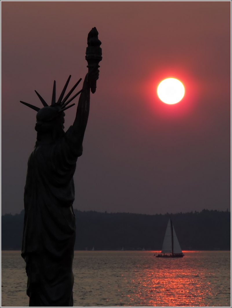
Thanks to Annika Bowden for that sunset view looking beyond Alki Statue of Liberty Plaza, where the last Saturday night of summer is being celebrated at the last Salsa on Alki Beach session of 2017. We watched the wildfire-smoke-reddened sunset a few miles south at Emma Schmitz Memorial Overlook:
 (WSB photo by Patrick Sand)
The National Weather Service says smoke will persist into tomorrow morning and then we can expect “rain at times in the afternoon.”
Multiple people have texted and e-mailed us today, certain something was on fire very nearby. Way too smoky and smelly for it to be the wildfires, again, they were certain. Nope, the Washington Smoke Information website says, the fires to our east are the culprit:
When the Canadian smoke model forecast some smoke in Seattle this morning, we thought it was over-doing the east winds. Turns out it wasn’t. Smoke from the Jolly Mountain and Norse Peak fire are now being transported to western WA.
But this won’t be another weeklong smother – “It is expected that these conditions will be with us until mid morning on Sunday.” And at some point after that, we’re promised rain. The National Weather Service says so too.
If you’re hoping to wake up to smokelessness … you might be disappointed. The National Weather Service’s Air Quality Alert for our area was extended and is in effect through noon tomorrow. And the waning-from-full moon tonight is still red/orange. The newest “forecast discussion” says they’re hopeful it will clear out by Friday, and there’s still some chance of showers on the way.

You saw it on cars … and in the air … but did you notice the wildfire ash in spider webs? We received two views – above, from Trileigh; below, Kathleen:

The forecast of improving air quality today (Wednesday) might truly come to pass … we’ve noticed over the past hour=plus that the full moon, which started as red as it was last night, is brightening.

With morning views like that one from Don Brubeck riding on the low bridge, above, and from Roy van Duivenbode, riding on the Water Taxi, below, you won’t be surprised to hear the National Weather Service has extended its wildfire-smoke-fueled Air Quality Alert for the area into tomorrow, now set to expire at 5 pm Wednesday.

The NWS’s latest “forecast discussion” acknowledges “many reports of falling ash” (we first mentioned it late last night), saying it “will likely continue” this afternoon. Here’s a car-top view of that, from David Hutchinson on Alki:

Back to the NWS update:
The smoke will actually help keep high temperatures down today. Have updated the morning forecast to reflect this with highs generally reaching into the mid to upper 80s over much of the area … The thermally induced surface trough along the coast will move into the interior late this afternoon helping start the transition back to onshore flow along the coast in the afternoon and evening. The heat advisory remains in effect for parts of the area today.
Weak low-level flow onshore tonight will help marine clouds work onto the coast and to a limited extend into the interior, reaching as far as (Shelton) by Wednesday morning. This will help improve air quality somewhat as smoke clears from the west overnight. It is likely that this clearing will mostly affect the coast and strait tonight, with smoke likely lingering into Wednesday over much of the interior. Have extended the air quality alert through Wednesday afternoon to reflect this.
No burn ban, though; we have a question out to the Puget Sound Clean Air Agency seeking information about that.
If you’re looking for wildfire updates – lots of info here. (And a smoke-specific update is here, with questions being answered in the comment section.)
P.S. Expect another red moon tonight – moonrise is at 7:41 pm, and it’s officially full just after midnight.

9:49 PM: Thanks to Ben Hutchinson for the photo! We were discussing the smoke-reddened almost-full-moon view on Twitter thanks to a heads-up from @WestSeaWx, but no image until Ben’s photo arrived. The color’s a lot like what we saw at sunset, vivid orange-red, now that wildfire smoke has moved back in – this time the Puget Sound Clean Air Agency says it’s coming west from the Cascades. And the National Weather Service has an Air Quality Alert for our area through midnight tomorrow night, citing Montana smoke moving this way too. This map shows the fires around the region:
Meantime, we’re also still under a Heat Advisory alert from the NWS>, through 10 pm Tuesday night.
11:11 PM: If you go out to look at the moon, you might notice ash in the air, too, and a light dusting on parked vehicles.

6:43 PM: Yes, we know sunspots don’t really affect Earth weather, but the photo David Hutchinson sent today still seemed a fitting image to go with news of a weather alert for the next two days. The National Weather Service has issued a “Heat Advisory“ for noon Monday through 10 pm Tuesday, saying the high temperature both days could get into the mid-90s. The forecast for both days also mentions “areas of smoke.”
P.S. Back to the sunspots – David points us to spaceweather.com for the explanation.
7:59 PM: Tonight brought a gorgeous sunset – James Bratsanos captured the color:

8:39 AM: And from the next generation of photos in James’s family, Ellie Bratsanos took this one:


What a sunset! (Thanks to Jim S. in Fauntleroy for the photo.) This time, though, the wildfire smoke that reddened the setting sun wasn’t from British Columbia, but from Oregon, according to the Puget Sound Clean Air Agency. More than 300,000 acres are burning in Oregon, according to this update from The Oregonian; the biggest is near the southern coast, as shown on this map.
(QUICK LINKS: Eclipse-viewing events … NASA’s live stream)
 (Eclipse through Patrick Taylor’s telescope at Myrtle Reservoir Park)
9:12 AM: We’re starting our eclipse coverage as more of a weather report. While it’s been sunny here in Upper Fauntleroy at ~300 feet, the fog’s rolling through again. We’re headed to check higher elevations. Updates to come.
9:22 AM: In general – if you’re socked in, head east/south. We’re at 35th/Thistle, and the sky’s blue both to the east (Highland Park/Westwood) and now to the north as we head toward High Point.

Myrtle Reservoir Park (35th/Myrtle; photos added above) is near the highest point in the city, lots of open space, and people are watching.
9:40 AM: Now arriving at High Point Library at 35th/Raymond. Big crowd. If you need a parking space, be prepared to walk a ways.
9:57 AM: The viewing party here is inside and outside. Outside, the view of the sun is on the east side of the library:

Thanks to everybody who offered to share their glasses – we took a quick look and even at partial, it’s amazing! Meantime, inside, the recently upgraded library meeting room has NASA’s live broadcast on the big screen:

The NASA stream includes a feed from the special Gulfstream aircraft that’s flying over the path of upcoming totality in Lincoln City, Oregon (read about it here) – it took off this morning from nearby Boeing Field, and is scheduled to return there around 12:30 pm.
10:04 AM: A lady here in the meeting room just announced to everyone that her daughter in Ocean Shores reports it’s “getting dark” there. In here, the NASA feed is having trouble due to overload.

Meantime, if you’re just going outside to see the near-totality, Lora Swift from the West Seattle Junction Association tells us skies are clear for their viewing party too (Junction Plaza Park, 42nd/Alaska, photo above).

And Jamie Kinney just tweeted the telescope-camera photo above.
10:34 AM: Maximum coverage has come and gone; the sun won’t be fully revealed again for about an hour in our area. More photos: First, eclipse “shadows” on the ground at High Point Library:

Peak-coverage crowd at High Point, with some “wows” and cheers:

At Junction Plaza Park, where Lora (who sent the photos from there) says about 200 people showed up!

Not far away, a few people went up to the roof at West Seattle Christian Church and sent this photo:

(added) At Jack Block Park – here are West Seattle High School teachers Joy Patman and Renee Phelps, eclipse-watching (thanks for the photos!):


Back to the sun and the moon – another photo from Jamie Kinney, taken at the 92 percent peak:

(Added: Here’s a gallery of Jamie’s images.) We will add video later that we rolled during the peak coverage. No, it did not get dark.
ADDED 12:45 PM: More photos – first, perhaps the most-enthusiastic eclipse viewer we saw:

Here’s High Point librarian Nathalie, who worked energetically to keep everyone informed of the eclipse status and what was going on at the library, inside and out:

Unique viewing apparatus included a colander:

Everyone we saw heeded the “don’t look without glasses” warnings:

One other unusual view – two Alki residents sent us this view of a “white rainbow” in the fog during the eclipse, looking across the low tide – this photo is from Lynn Hall:

Another gathering spot – Providence Mount St. Vincent. (Thanks for the texted photo!)

ADDED 5:32 PM: Thanks to Greg Snyder, a West Seattleite who went to Cascade, Idaho, to be in the totality zone, and shared this image:

And thanks to those who are sharing photos in the comment section below!
AND MORE: From Tom Stoner, another view of the “vegetation shadows” that showed the eclipse:

Another totality view – this one from Alki photographer David Hutchinson, who went south to watch, from “south of Baker City, Oregon, at the Weatherby Rest Area along I-84”:

P.S. The next solar eclipse visible in the U.S. will be in April 2024 – but nowhere near here.

Thanks to James Bratsanos for the photo of tonight’s sunset – colorful without wildfire-smoke enhancement. It was also spectacular before the sun emerged from the clouds, as Don Brubeck‘s photo from Alki shows:

Five weeks left in summer … the autumn equinox is at 1:02 pm our time on September 22nd.

Thanks to David Hutchinson for the Friday night sunset photo from Alki Beach. He noted, “Nice to see some actual clouds and blue sky – not just the smoke.” And this time, the Puget Sound Clean Air Agency says it’s not expecting an encore.
As predicted, the air is clearing. The Puget Sound Clean Air Agency has lifted the burn ban; the National Weather Service no longer has an air-quality alert in effect. And the latest forecast has a chance of showers overnight tonight, more of a chance tomorrow night.

West Seattle pilot/photographer Long Bach Nguyen sent that photo, saying he thought neighbors here would be interested to see just how far out, and high up, the wildfire smoke has spread. If you’ve been wondering about relief – forecasters say it’s on the way, even before the chance of showers predicted for this Sunday. The updated Air Quality Alert for the region says, “Conditions are expected to begin improving Thursday night, but even more so on Friday as strengthening southerly flow aloft pushes the smoke out of the area.” So all those eerie views should soon be a memory – including sunset/sunrise views that even revealed sunspots, as Kersti Muul‘s photo shows:

As for the source of the smoke – British Columbia expects some rain, but not enough to extinguish the wildfires.
The resurgence of wildfire smoke has the Puget Sound Clean Air Agency bringing back a Stage 1 Burn Ban, as of 2 pm today, two days after the previous one was lifted. From the official announcement:
No burning during a Stage 1 air quality burn ban including:
• No charcoal barbeques or similar solid fuel devices
• No fire pits, chimineas, fire bowls, or similar free-standing devices
• No campfires or bonfires
• No fireplaces, uncertified wood stoves, or uncertified inserts*
• No agricultural fires (as described in the agricultural burn permit)
• Local fire districts do not grant Native American ceremonial fire permits outside of tribal
lands during air quality burn bans.
It is OK to use natural gas and propane grills, stoves, or inserts during a Stage 1 burn ban.
* The only exception to using fireplaces and uncertified wood stoves or inserts, is if the homeowner has a
previously approved ‘No Other Adequate Source of Heat’ exemption from the Clean Air Agency
Meantime, here’s the latest on the B.C. wildfires.

Thanks to everyone who sent photos from last night’s red-again sunset – above is by Harry Pohlman; below, by Jim Borrow. We thought we’d wait to see how things looked this morning before publishing a weather update.

Verdict: No change. Still smoky. The National Weather Service has a Special Weather Statement about that saying the smoke is expected to persist at least through Saturday – and its Excessive Heat Warning is still in effect through 9 pm tonight, though temperatures haven’t been quite as high as feared. Last night, we also had multiple reports of what seemed to be ash accompanying the smoke – let us know if you’ve noticed that. And the Puget Sound Clean Air Agency‘s Stage 1 Burn Ban – no outdoor burning – continues TFN.
 (Photo by David Hutchinson, from Alki Beach)
Thank you to everyone who sent photos from tonight’s sunset, reddened by wildfire smoke that kept thickening as the day proceeded. Up in British Columbia, the smoke is hindering the fight against the fires that are causing it.
 (Photo by Jamie Kinney, looking over the Fauntleroy ferry dock)
Our state has fires burning too, but nothing like what’s going on in B.C.
 (Photo by Jim Borrow, from Upper Alki)
You can check the air-quality status on the Puget Sound Clean Air Agency website.
 (Photo by Gary Jones, from Alki Point)
And remember we’re still under an Excessive Heat Warning alert through Friday night.
 (Photo by Jeff Kaufer, from Constellation Park)
The smoke is even mentioned in the forecast.
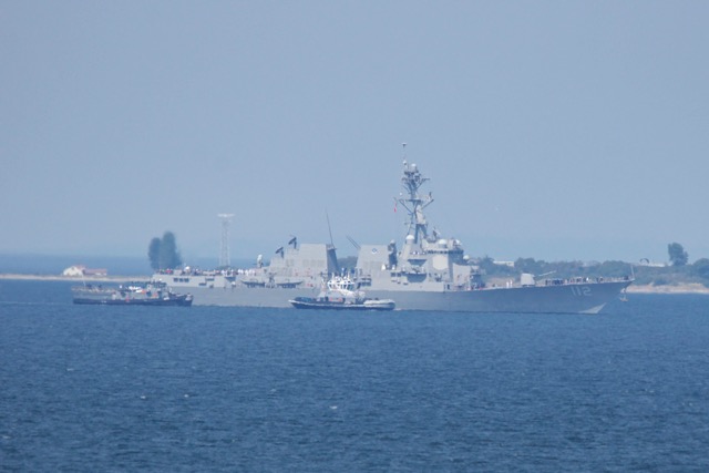
Thanks to Gary Jones for the photo – while we were covering the plane recovery off Beach Drive, he was photographing the Arleigh Burke-class guided missile destroyer USS Michael Murphy (DDG 112) passing Alki Point, arriving for Seafair Fleet Week. Tomorrow (Wednesday, August 2nd), the Pearl Harbor-homeported ship is scheduled to (again) sail past West Seattle’s north-facing shore, headed to downtown, during the Seafair Parade of Ships – 1 pm is the official start time, but in past years they’ve appeared off Alki closer to 12:30. The full Parade of Ships lineup – scheduled to include another Navy ship, a U.S. Coast Guard cutter, and two Royal Canadian Navy vessels – is on this Seafair webpage, along with information on touring them Thursday-Sunday.
ABOUT THE HAZE: You might notice the photo looks a little murky. The air’s grown increasingly hazy in the past few hours, and @WestSeaWx says it’s wildfire smoke, mostly blowing down this way from British Columbia, which is being hit very hard this season.

Today’s other big story: The heat-wave warning keeps intensifying. This morning, it was upgraded to an Excessive Heat Warning, with this summary for the area:
Unusually hot weather is forecast to begin Tuesday and continue through Friday. Widespread record highs are expected Wednesday and Thursday. Thursday should be the hottest day for most spots when highs will probably be within 5 degrees of the all-time records. Highs on Tuesday will be in the mid 80s to lower 90s, warming to the 90s to near 104 on Thursday. Friday will be slightly cooler, but highs will still be in the upper 80s and 90s.
The warning currently covers 2 pm Tuesday through 9 pm Friday. Meantime, the city is out with a long list of places to stay cool. Here are the West Seattle spots:
The following Seattle Public Library locations are equipped with air conditioning, and serve as cooling centers when the area experiences extreme heat. Please call the individual location before you go for open hours and to verify that the air conditioning is working. (Here are the two in West Seattle:)
·Delridge (5423 Delridge Way SW) – 206-733-9125
Monday: 1 pm. – 8 pm, Tuesday: 1 pm – 8 pm, Wednesday: 11 am – 6 pm, Thursday: 11 am – 6 pm, Friday: closed
·High Point (3411 SW Raymond St.) – 206-684-7454
Monday: 1 pm – 8 pm, Tuesday: 1 pm – 8 pm, Wednesday: 11 am – 6 pm, Thursday: 11 am – 6 pm, Friday: 11 am – 6 pm
The following senior centers have air conditioning or are relatively cool and are open to the public. Please call the individual location before you go for open hours and to verify that the facility is cool. (One West Seattle location:)
·Senior Center of West Seattle (4217 SW Oregon St) – 206-932-4044
The city also recommends wading pools and sprayparks – the full list is here; we always include a list of what’s open each day in our what’s-happening list. Outdoor Colman Pool (schedule here) is currently open 7 days a week on the shore at Lincoln Park, as is indoor Southwest Pool (schedule here) at 2801 SW Thistle.
As for air-conditioned restaurants, bars, coffee shops – we don’t have the horsepower to make 100+ calls to ask them all, so we would love your help – if you own one with A/C, and/or know of one, please either e-mail us (editor@westseattleblog.com) or comment below, and we’ll include it as this sizzling week goes on.
P.S. And PLEASE heed all the reminders about not leaving children, seniors, pets in hot vehicles (or other confined spaces) for even a moment. Plus, think of our feathered friends and fill up bird baths (or make temporary ones – we have Christmas-tree stands outside) so they have water for drinking and bathing.
| 1 COMMENT