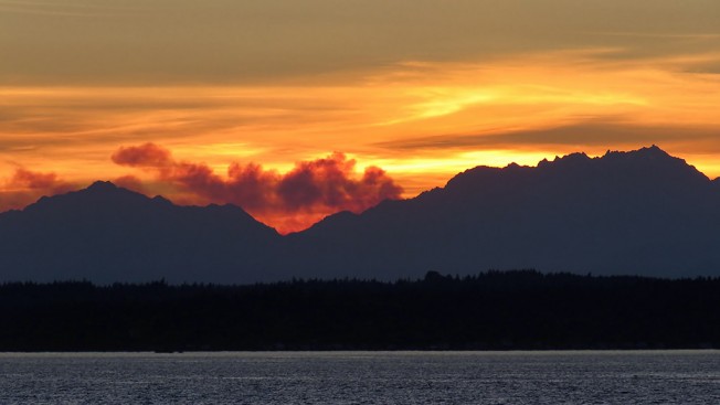
Seen from West Seattle: Olympic Peninsula wildfire smoke

20160819 202030 Fire in Olympic NP - 1024x576

Thanks to David Hutchinson for the photo (and to Terry Burns for sending one too) – wildfire smoke from the Olympic Peninsula was clearly visible at sunset. While looking at tonight’s sunset, noticed what appears to be smoke from a fire in Olympic NP. David sent this link, where an update from yesterday says, “There are currently four small, lightning-caused fires burning in the Olympic National Park wilderness. Although there is no threat to visitor safety or facilities at this time, smoke may be visible. ‘Red flag’ conditions are expected for the next several days.” The Peninsula Daily News has a story from this afternoon with a few more details. The southernmost of those four fires is the Ignar Creek Fire, which looks like it might be in the right spot to generate what was seen here.

6 Replies to "Seen from West Seattle: Olympic Peninsula wildfire smoke"

  • Etm August 19, 2016 (8:59 pm)

    From Inciweb…2 fires have grown today and a trail is closed as well as Obstruction Point Road.

    Inciweb is “go to ” site for all wildly different fires

  • Etm August 19, 2016 (9:00 pm)

    Oops…should have been all wildland fires

    • WSB August 19, 2016 (9:02 pm)

      Thanks. That info is in the Peninsula Daily News link – they are my go-to place when something’s happening on the other side of the Sound. Still looking for even closer sources … just out of curiosity.

  • Zoots August 19, 2016 (9:50 pm)

    We saw the same thing from Ballard at sunset. Puget Sound Clean Air should be putting out air quality warnings, but they are off for the weekend (!). So we’re apparently on our own for issues like…um…breathing. Their indicators will stay green until Monday, I guess. 

    Thanks for verifying what we saw.

  • Peterman August 19, 2016 (10:48 pm)

    Is this a real comment?  

  • abovealki August 20, 2016 (7:41 am)

    I think the smoke would be from the Hayden Pass fire, which is due west up the Dosewallips River valley. The photo shows Mt. Jupiter on the left and Mt. Constance on the right, with the Dose in between.

Sorry, comment time is over.