West Seattle, Washington
15 Wednesday
Westcrest Park, home to West Seattle’s only off-leash area, got a microburst of attention recently after a tv report about public sex in the park. However, frequent visitors are focusing right now on a different concern — theft. A member of the Westcrest Off-Leash Area Yahoo! group asked us to get the word out about two thefts this week alone. The victim of the first one reported that a man stole her purse out of her car while she was just feet away unloading dogs. The purse contained her cell phone; here’s what she tried a while later:
“I also called my cell phone and the guy answered it. I told him I would be filing a police report with a description of him and his car and the theft and he told me to F off.”
The other theft happened today, according to a note posted by park steward Steve:
“We got hit again this morning, Wednesday, about 10 am. This is getting really ridiculous. I’ve been to the south precinct on Delridge to ask if they could patrol the lot once in a while, but no one was even there. Perhaps others could stop by there to ask as well ..squeaky wheel theory. Once again, I don’t think anyone is looking out for us except for us.”
The National Weather Service‘s nighttime “forecast discussion” is online now, and the predictions haven’t changed much. The strongest wind tomorrow is expected out at the (ocean) coast and up Whatcom/Skagit/Whidbey way, but we’re still likely to get gustiness here in the big city. Excerpt, including talk about a second storm to follow:
PLENTY ENOUGH SUPPORT FOR THE CURRENT FORECAST WITH WARNING CRITERIA (GREATER THAN 40 MPH SUSTAINED AND/OR GUSTS 58 MPH OR MORE) OVER THE COAST AND NW INTERIOR. STILL IFFY IF THE CRITERIA WILL BE MET ELSEWHERE…BUT IT WILL BE WINDY REGARDLESS. ENOUGH FOR AN ADVISORY ANYWAY. THE STRONG WINDS WILL LAST THROUGH A LARGE PART OF THE DAY FOR THE COAST…WITH THE STRONGEST WINDS OVER THE INTERIOR DURING THE MID AFTERNOON INTO THE EARLY EVENING…THEN EASING UP INTO THE LATE EVENING HOURS.
ON FRIDAY…ANOTHER SYSTEM WILL MOVE INTO THE AREA WITH PLENTY OF RAIN AND CLOUDS AND CONTINUED COOL TEMPERATURES. WIND WISE…THIS SYSTEM LOOKS A GOOD DEAL WEAKER THAN THE THURSDAY SYSTEM…BUT IT WILL HAVE A DECENT SW BREEZE IN ITS WAKE. THE OFF AND ON WET WEATHER IS EXPECTED TO CONTINUE INTO THE EARLY PART OF THE WEEKEND.
This comment just in from Garybert on the original “opening this Friday, preview Thursday” post:
Stopped by Ama-Ama around 3:30 to see if we were on their list. Very full for Thurs, but having “Soft Opening†TONITE! Just returned from a great meal with less glitches than a normal experience. Seafood chowder is a great buy.
Mixed Green Salad and Salad with Shrimp are very good. Black cod was cooked perfectly and Monk fish was “interestingâ€Â. No wine yet, but they did have beer. Might be worth checking into to see if there is still more room tonite.
First — King County leaders have chimed in, including preparedness advice; read it here. (Helpfully, that page includes this link to more information about food spoilage when your fridge loses power; that was a big point of confusion for us and others during the longterm outage last year.)
Second — the city Transportation Department issued this alert, including a phone number that is worth writing down someplace:
Stormy conditions are forecast for tomorrow’s afternoon commute period. An abundance of leaves brought down by the wind and rain may clog street drains and result in spot flooding. Drivers should use caution and proceed slowly where water has accumulated on the roadway, and should not drive through deep water.
In the event of heavy winds, trees and branches or other debris may fall into the roadway, and power may be lost in some areas. Drivers should be alert for obstacles on the roadway, and treat dark or twisted traffic signals as all-way stops. Blocked roadways, damaged traffic signs or malfunctioning traffic signals within the City of Seattle may be reported to SDOT’s 24-hour Street Maintenance Office at 206.386.1218.
Today SDOT crews readied equipment and supplies to prepare for tomorrow’s forecast of bumpy weather. The crews are ready to clear roads of storm debris, repair damaged traffic signals and signs, and work with other city departments to keep roads open and power on throughout the city.
Press release just out of the inbox. Please note the line about the trees — go check yours if applicable:
With a windstorm expected in the greater Seattle area Thursday evening, Seattle City Light is preparing crews and stocking its trucks to respond to any outages that occur and restore service.
The National Weather Service is forecasting sustained winds of 25 to 35 mph and gusts of 40 to 50 mph. The peak of the storm is expected between 3 p.m. and 9 p.m.
Winds of that level are slightly stronger than a typical winter storm in this area. They have the potential to damage the electrical system, causing outages.
One particular concern is trees that were damaged in last December’s major storm but are still standing. Those trees have been weakened and are more susceptible to wind. Also, because many of the trees still hold a majority of their leaves, they act more like a sail in catching the wind, further increasing the risk.
On the good side, soils are not saturated, giving trees more of an anchor. City Light also has trimmed trees along more than 100 miles of power lines this year to provide clearance that helps reduce the likelihood of damage.
Residents are encouraged to take this opportunity to get prepared for winter storms and other emergencies. Three ways you can begin preparing today are to make an emergency plan for your family, build an emergency kit and get involved with your neighbors.
You can learn more at www.seattle.gov/emergency.
The National Weather Service has just published its latest “forecast discussion,” and it’s still calling for strong winds tomorrow afternoon/evening:
THE STRONGEST WINDS IN THE PUGET SOUND AREA WILL OCCUR DURING THE LATE AFTERNOON AND EARLY EVENING. AS FOR HOW STRONG…IT ALL DEPENDS ON HOW TIGHT THE SOUTH TO NORTH PRESSURE GRADIENT IS…WHICH DEPENDS ON THE TRACK OF THIS SYSTEM AS IT MOVES ONSHORE. AT THIS TIME WE ARE EXPECTING SOUTH TO SW WINDS 25 TO 35 MPH WITH GUSTS TO 50 MPH FOR THE INTERIOR.”
While we await the next update on the High Wind Watch that’s in effect for tomorrow for most of the region — we just got a beautiful photo of yesterday’s stunning sunrise, courtesy of Steve Fischer, who took pix while waiting for the Water Taxi.


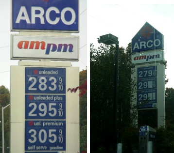
As the photo montage above shows … many WS stations have suddenly jumped up past 3 bucks a gallon for regular unleaded. (Here’s why.) Fauntleroy/Alaska Shell, for example, has had at least two price hikes in the past day — one to $3-plus by late last night, then up to $3.12 as of first thing this morning. Delridge Arco still has the lowest price but as the photos below show, as of about an hour ago, its signs don’t really agree on what the price actually is (we didn’t stop to check the pumps):
From the link we mentioned earlier this morning, where National Weather Service meteorologists elaborate at least twice daily on what they see heading this way, the newest “forecast discussion” is now published, including this excerpt, referring to tomorrow (Thursday): “FOR THE PUGET SOUND AREA…APPEARS THAT THE STRONGEST WINDS WILL OCCUR DURING THE LATE AFTERNOON AND EARLY EVENING HOURS AS A STRONG SOUTH TO NORTH PRESSURE GRADIENT DEVELOPS.”

We’ve talked before about the teardown-to-townhouse plan for the 57th/Alki corner (across from Alki Automotive) now mostly occupied by the stately brick Shoremont Apartments (photo above). After WSB reader Fiona e-mailed to point out (thank you!) that the parcel suddenly turned up the other day listed for sale for $2.2 million, we published a post about it half an hour ago – then double checked the listing link – which originally had ad verbiage suggesting the project could proceed OR the apartments could stay (or some combination?) – but that link (as you’ll see if you click it) is suddenly no longer good; sometime in the past 24 hours or so, the listing went away. We’re looking to see if evidence of it is still out there somewhere (that’ll teach us, we need to get screen grabs of everything!), so far can’t find it. Sold, or “never mind”? Fascinating.
Unless you moved here after Windstorm 2006 last December, you may be quaking like a leaf in the breeze at the prospect of the High Wind Watch alert just issued this morning — after all, West Seattle got hit the worst in that December-to-remember wallop, with most of us losing electricity for at least a few days. The city promises it will do a better job of getting out information this year regarding when the juice is coming back; crews have also been out for weeks trying to take some preventive action – we saw city tree trimmers along Cali just a few days ago. So get your batteries (laptop too!), your firewood, your blankets, your nonperishable food and drink, and hang on. As for the latest on whether Windstorm ’07 is really on the way, besides the usual collection of basic online forecasts (we like Weather Underground), here’s a great page to watch, with behind-the-scenes talk about what the real experts are seeing: The local National Weather Service “forecast discussion,” updated several times daily.
| 13 COMMENTS