By Tracy Record
West Seattle Blog editor
Now that the Fauntleroy Boulevard project is funded and approaching construction, it’s getting even-closer public scrutiny, and that brought a briefing and Q&A at last night’s meeting of the West Seattle Transportation Coalition, which has talked about it many times before.
Close to 30 people were there, including an SDOT delegation led by Fauntleroy Boulevard project manager Norene Pen and project communication lead Rachel McCaffrey, who launched the briefing with background:
The project area is .4 miles long, and the concept dates back to 1999 discussions. Part of the project involves the Bicycle Master Plan‘s designation in 2014 of Fauntleroy Way for a protected bike lane. Outreach to adjacent property owners, and discussions, started in 2014-2015. Early ’15 is when the project was “put on hold” for lack of funding; then it was added to the Move Seattle levy, approved by voters in November 2015. She said they’re aware that the partial design that’s just been “re-initiated” is two years old and they are assessing current conditions to be sure it still works, as they then finalize design and move toward starting construction “late 2017 or early 2018.”
The project’s 3 main goals:
*Respond to community needs in Triangle plan and Bicycle Master Plan
*Enhance Fauntleroy’s role as a “key entrance” to West Seattle
*Improve mobility by organizing the street to be more predictable and comfortable for everyone: people driving, walking, or biking
She went through a slide of how they’ve responded to “community feedback.”
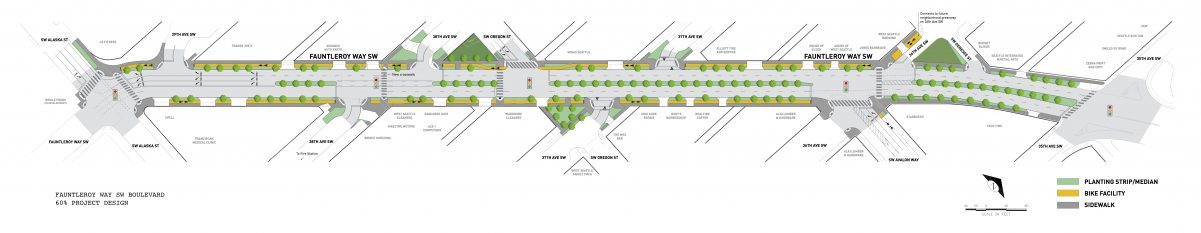
Project manager Pen took over the presentation, showing the now-familiar cross-section with sidewalk, bike lane, treed mini median, two travel lanes each diredction, treed median OR turn lane, then mini-median, bike lane, sidewalk on the other side:

(Cross-section from city project page)
He said the 60 percent design status means they’re working on finalizing landscaping, among other things. They are going to do it all within “city right of way” – they’re not looking to purchase (or otherwise acquire) any private property for it. Currently, that right of way includes a lot of “broken sidewalk” among other mobility challenges. What looks like a mini-median also will include utility poles, just taking them out of paths. While power won’t be entirely undergrounded, the poles will be fed from underground instead of overhead, Pen said.
He discussed the project in sections, starting with Alaska east to 38th. The corridor overall has five signalized intersections as well as some unsignalized, and the design will make them “a little more perpendicular” so that, among other things, drivers entering Fauntleroy will have a better line of sight, and pedestrians will have a shorter crossing distance. The signal for emergency vehicles at 38th (serving Fire Station 32, which is being rebuilt on its longtime site on Alaska) will be upgraded to become a pedestrian-activated (with push-buttons) signal.
From 38th to 37th, more crossings will be straightened out, including what is currently asphalt outside the dry cleaners and turned out to be city property that will be transformed into a landscaped triangle. An alley that currently enters the Fauntleroy/Oregon intersection will no longer do that. Pen noted that current design standards have changed a bit from the 2014 graphics he was showing, while a right turn onto westbound Oregon will be allowed, the right-turn “pocket” will be removed.
37th to 35th, there will be some “signal modifications” at 35th and Fauntleroy but no rechannelization – “that would be a major task in itself” if they did, Pen said. The Fauntleroy bicycle lane stops at Avalon on the eastbound side and starts at 36th on the westbound side. No right-turn lane onto Avalon, he noted.
One slide looked at intricate details of what level of service the right-turn pocket intersections would end up at and whether they were eligible for “improvements.” They don’t have study results for Fauntleroy/Oregon and Fauntleroy/Avalon yet, Pen said. “So when we look at eliminating the right-turn pockets, we were showing the right turns operating at (extremely low) delays for the AM and PM pocket,” and apparently not much delay even without the pockets. The previous study projected what conditions would be like in “opening year of 2017”; they’re re-studying for “opening year of 2019.”
Another key point: They’re deciding how to handle traffic during construction, whether to keep the stretch flowing both ways, one lane each way, or keep it two lanes one way and route the other direction onto Alaska and then to 35th. The latter might reduce the construction time by as much as two months. (It’s currently projected to last about a year.)
McCaffrey took back over to say they’re now re-launching conversations, from meetings like the WSTC, to one-on-one conversations with business owners in the corridor. She also mentioned the mid-March “Walk-and-Talks” (we published the announcement Wednesday), which she described as “moving open houses” with stops along the way. 90 percent design will be achieved this spring, with finalization of design over the summer.
Next, Q&A.
WSTC vice chair Martin Westerman described recent three-block-plus backups in the area and wondered if the studies to date took factors leading to those into account.
Pen said that while their numbers are averages, there might be a cycle at some point where people are waiting longer than the averages. So their new studies will include “microsimulation.”
WSTC board member Mark Jacobs, a traffic engineer by trade, interjected that SDOT should be studying further out – 15, 20 years – with its projections.
“The more years you go out, the more you’re just (guessing),” Pen countered. They’re focusing right now, he said, on trying to ensure they won’t be botching things with the removal of the right-turn pockets.
WSTC board member Larry Wymer, also a traffic engineer by trade, asked about whether certain methods were used. Pen said what they use enables them to compare year by year, to be sure “we didn’t just capture an odd day,” to ensure they have “the right factors.”
An attendee wondered if the statistics were looking at vehicle delays or people delays – counting for example 100 cars with one person in them the same as one bus with 100 people. Basically, their counts focus on the former more than the latter, said the SDOT reps.
Westerman then expressed concern about whether SDOT was considering growth stats/projections that really corresponded with the growth in the West Seattle Junction area, which is often cited at having hit 300+% of the growth that wasn’t expected until next decade.
Other questions included one from board member Jon Wright about pedestrian safety at Oregon and Avalon, minus the turn pockets. The crossings will be shortened, said Pen, and will be more comfortable, predictable, organized, safe. Wright noted that “pedestrians don’t usually get a whole lot of respect” at those intersections now. SDOT pointed out that if the light is green in the direction the pedestrian is going, vehicles are legally required to stop for them.
WSTC board member Chas Redmond asked about the status of the Alaska crosswalk from The Whittaker (WSB sponsor) to Spruce. “Who’s doing it and what is the timetable? No one seems to know.” SDOT wasn’t entirely sure. (For the record, it’s supposed to be part of The Whittaker project. Former City Councilmember Tom Rasmussen noted this a bit later in the meeting, with a reminder that it was required as part of the public-benefit package for the project.) If the Alaska detour is used during construction, Redmond also asked, what happens to the bus lanes on Alaska in The Triangle? Pen said they will “work with Metro” on that. Redmond said he’s concerned about something getting broken and not fixed, pointing out the California/Fauntleroy RapidRide problem in Morgan Junction that is acknowledged as broken but after four years not in line to be fixed.
Next question: When are the traffic counts done? Three hours in the am and three in the pm, said Pen, and then they take the highest-volume days/nights. “We don’t just look at the numbers, we go out in the field to validate, and to check ‘did the numbers miss something?’.”
Then: What about the Trader Joe’s loading zone in front of the store? “We’re relocating their loading zone onto 39th,” said McCaffrey. “We’ll work with them on it and if it becomes a problem, we’ll re-evaluate, but we’re (also) working with them on loading on Fauntleroy in the middle of the night.”
And: How does all this work with Vision Zero safety goals? McCaffrey said more predictability will mean more safety – without the right-turn pocket, cars waiting to turn will have to stop for pedestrians. Turning more of the intersections into 90 degrees will also give pedestrians more visibility if someone is (illegally) not going to stop for them. Especially at Oregon, Pen said, removing the pocket will slow down turning traffic, which currently can come off Fauntleroy and head rather quickly westbound onto Oregon.
Next: What about the sizable stretch of Fauntleroy left without signalized intersections? And what about turning into driveways?
McCaffrey said they’re doing studies right now to see if another break in the median would be warranted, depending on where and how often left turns are being made.
Board member Deb Barker asked about the right of way on the east side of 35th and thought SDOT seems to be “missing a huge opportunity” in a variety of ways, including that people accelerate to get onto the West Seattle Bridge, so this is a spot where safety could be improved. She called attention to the two microhousing buildings a block south at 35th and Avalon. “On behalf of the neighborhood, I’m urging you to take a look at that side of the intersection and finish the boulevard where it actually starts.”
An attendee wondered about access to some of the buildings on the south side of the area, and an apparent lack of east-west flow – from 35th to 42nd without being on Alaska. To reply, McCaffrey pointed out the median at 37th, saying that they are currently studying the volume of left turns to see if there is reason for a break in the median there.
Taylor-Judd ended the question period there. Nearby resident and longtime community advocate Sharonn Meeks offered a comment to WSTC, saying that the project is important because the area is dangerous for pedestrians – she would like to walk to Trader Joe’s, for example, but she’s afraid she’s “going to get run over.” This project, Meeks declared, will unquestionably increase safety so that “pedestrians can reclaim our neighborhood – because we don’t live on a highway, what we have is a bridge that goes to highways – I want to see it slow down so we can reclaim our YMCA,” among other places. “I think this is a critical project at a critical time, it’s been well-vetted since 1999 – I’ve been there – and I hope we can come to some conclusions that make it work for all of us.”
Taylor-Judd warned that “One of the risks with pushback at this point is not, can we improve the project more, but if we hold it up, will the money go elsewhere, and will it be another five years, another seven years, before (it comes back) … this is really about being ready to go, and (the spot) they have in the SDOT schedule to start construction.”
WANT TO KNOW MORE? Here’s a Q&A document from the project website.
WHAT’S NEXT FOR FAUNTLEROY BOULEVARD? Three discussion opportunities are coming up, as published here – the new Fauntleroy Way Association of business and residents meeting next Wednesday (details here), and the two SDOT walk-and-talks in mid-March (details here).
Also discussed, but without a project presenter
ONE CENTER CITY: We first wrote about this a month ago (and should note that the city has a paid advertisement running on WSB for continuous access to the “online open house“). It could mean big changes for routing on downtown streets when the Convention Center project gets going and buses are kicked out of the Transit Tunnel. Chair Taylor-Judd said he’s concerned that a developer is getting this kind of access to result in a “huge impact” in time and money for people trying to get to and through downtown. The potential rerouting of West Seattle buses, in particular, and the possibility of people being required to switch to light rail, was called out – this graphic is from the middle of the aforementioned “online open house”:

Isn’t this going to add to carbon emissions, counter to city goals? wondered Redmond. Others wondered if the project in general is getting enough discussion citywide.
WSTC will look into bringing someone in for a briefing. (When we published our report in January, there was no community meeting planned, but the coalition behind the project said they’d be happy to send reps to groups’ meetings if requested through info@onecentercity.org)
OTHER WSTC BUSINESS: A new member is joining the board, Admiral resident Paul Buchanan. Two vacancies remain; chair Michael Taylor-Judd said they’re hoping one will go to a local business rep. … The group reviewed a draft version of a list of its accomplishments that’s being put together as an informational one-sheet … On the printed agenda, this list of half a dozen areas/projects that comprise the top legislative priorities for WSTC:
*West Seattle Bridge Transportation Corridor
*Sound Transit 3 planning for light rail to West Seattle
*Fauntleroy Boulevard project
*35th Ave. SW (traffic calming and rechannelization)
*Delridge Way (multimodal projects and [future] RapidRide)
*Highland Park Way roundabout
The West Seattle Transportation Coalition meets fourth Thursdays most months, 6:30 pm, usually at Neighborhood House’s High Point Center (6400 Sylvan Way).
| 5 COMMENTS