
Thanks to Cindi Barker for pix of two events this morning and afternoon – first, the Orchard Street Ravine planting party in Gatewood. Cindi reports volunteers “focused on planting the remaining plants provided by Parks right before the snowstorm and mulching everything around the trail and up on the steep east slope.” Here’s a wider shot – the orange flags, Cindi says, mark spots where Parks Department employees did some planting right before last month’s freeze/snow:
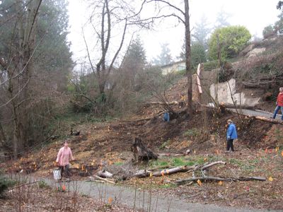
Can’t quite place OSR? Here’s a map; here’s our coverage of its dedication three months ago. Meantime, Cindi also provided photos and info from an event this afternoon that was her brainchild, an informal Google Map-making workshop with Alice Enevoldsen, who turned WSBers’ road reports into fabulously helpful G-maps during Snowstorm ’08. Half a dozen people showed up for the gathering at Uptown in The Junction – although Cindi reports it took a bit of a low-tech turn:

Uptown’s wi-fi was having trouble, so Alice resorted to pen and paper for a while. Then a nearby signal was acquired and she was able to get back to demonstrating via the actual website:

If you missed it – Google Maps do have online tutorials, although that’s seldom a substitute for watching somebody like Alice who knows their way around. Thanks again to Alice for being so generous with her time and talents. One last photo to share right now – we certainly agree with JayDee when he sent this under the heading “It was nice to see the sunset tonight”:

Looks like the sun might make an appearance again tomorrow.
| Comments Off on West Seattle weekend scenes: Orchard Ravine, Alice’s maps, sunset