You asked, so we asked: What do users of north stretch of Highway 509 need to know about tolling on new south stretch?

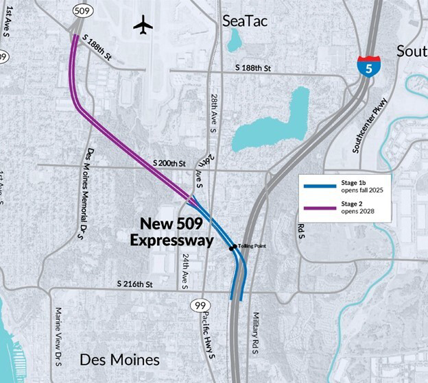
With the north stretch of State Highway 509 running past southeast West Seattle, you might be wondering what you need to know about the tolling that starts tomorrow on the newly opened southern “expressway” stretch. Jennifer emailed us after noticing what appeared to be a transponder on the Normandy Park exit, and wondered if that meant the tolling will go that far north. We took the question to WSDOT‘s Kris Olsen, who sent the map you see above, underscoring that only the green mile will be tolled starting tomorrow (and will remain the only tolled section for a few years):

Only the first mile of the new expressway is open. The first mile is between I-5 and 24th Avenue South, so that is the only portion that will be tolled right now.

The remaining 2 miles between 24th Avenue South and South 188th Street (the Normandy Park exit) won’t open until 2028 and that’s when tolling will begin in that section.

But even then, Olsen continues, the tolled section will go no further north than S. 188th:

It’s important to note that the existing sections of SR 509 (basically between the First Avenue South bridge and South 188th Street) will NOT be tolled. Starting in 2028, anyone who drives south on SR 509 must exit at South 188th Street if they do not want to pay a toll. If they continue south beyond that point, they will be tolled. The tolling gantries are located just west of the I-5 interchange.

Toll rates for the new one-mile expressway, starting tomorrow, are listed here.

15 Replies to "You asked, so we asked: What do users of north stretch of Highway 509 need to know about tolling on new south stretch?"

  • WS Neighbor September 28, 2025 (6:22 pm)

    How confusing!     “only the green part will be tolled starting tomorrow” ….I don’t see any”green part” on this       https://wsdot.com/

    • WSB September 28, 2025 (9:08 pm)

      I don’t know what map you’re looking at on the WSDOT site but that line refers to the WSDOT map at the top of the story, which they provided us as the most user-friendly map of the ones they published …

      • JB September 28, 2025 (9:39 pm)

        The legend on the map above is bluish (probably referred to as green) and magenta. Maybe the blue part is the tolled part. Can’t zoom in on images from iPhone – the site needs an update for mobile users- it’s not great and mobile is the majority I’d suspect. 

        • WSB September 28, 2025 (10:57 pm)

          Looks green to me but whatever the case, it’s the section described by WSDOT. As for zooming, I can zoom in to images or text or anything else on both our iPhones (different models, both a few years old, one with the newest iOS and the other one lagging), so I don’t know what the problem is there – our mobile display is delivered via a plug-in that’s definitely updated – TR

          • Delridge September 29, 2025 (12:27 am)

            Mobile site is fine, but the map on this post looks blue to me too. 

        • No zoom September 30, 2025 (8:00 am)

          Same, have never been able to zoom viewing blog on a phone. Not images, not text. Bummer 

          • WSB September 30, 2025 (10:53 am)

            If you’re having that problem and can spare a moment, please email us what device/OS you’re using so we can try to troubleshoot. westseattleblog@gmail.com

  • Ferryboat September 28, 2025 (7:51 pm)

    Thanks for reaching out and getting the clarification from WSDOT.  

  • onion September 28, 2025 (8:49 pm)

    So 509 between  S 188th and S 24th is still under construction and not useable as a western bypass of SeaTac Airport and I-5? I didn’t realize that and was planning to give it a try. Good to know.

  • 1994 September 28, 2025 (10:09 pm)

    I drove the new short stretch of 509. Can’t believe the WA DOT is tolling for this stretch that takes maybe 30 to 40 seconds to drive. And when you arrive at the end of the new highway you are a bit confused where you ended up. Going right takes you north towards the airport. I don’t see myself paying to drive a more direct route (when the 509 is completed in 2028) to West Seattle just to alleviate the traffic on the other 2 routes to West Seattle via the 518 or 599.

    • IDC9 September 29, 2025 (1:36 am)

      I agree that WSDOT should not be charging tolls on this new, very short stretch stretch of 509. Who is going to want to pay up to $2.40 or whatever they’re charging to drive on what are basically glorified on and off ramps right now? Certainly not me! I appreciate the need to cover the costs of this project, but this is not the way to do it. When stage 2 opens, then it would make more sense to charge tolls. But even then, its not a particularly long stretch of highway, and it is readily avoidable. The tolls might not be the financing solution that WSDOT thinks they are. We’ll see what happens, but color me unimpressed.

  • andrew September 29, 2025 (12:50 am)

    they want to charge 2 to 4 dollars, a fancy coffee, just to skip over pac highway, a couple blocks distance, and get dumped in the middle of nowhere, way south of the airport entrance. let’s see how this plays out 

  • Joel September 29, 2025 (7:07 am)

    Another bad decision on the part of WSDOT. Not to mention signage from I-5 North is horrible! You wouldn’t even know you are on “509”! The exit is 24th street and not worth a toll. I also question the massive advertising campaign, how does WSDOT justify spending money on that? 

    • BlairJ September 30, 2025 (8:25 am)

      I imagine WSDOT did not want drivers being surprised to be charged a toll for taking a freeway exit.

  • Mark Schletty September 29, 2025 (4:24 pm)

    This is just another bad joke from WSDOT. Anyone who pays a toll for this little bitty stretch of roadway to nowhere is a fool. WSDOT should be ashamed of themselves for the ads on this roadway supposedly connecting  I5 and 509. They grossly misinform the public. 

Sorry, comment time is over.