
It’s drawn the most support at West Seattle public meetings about what will replace the “central waterfront” section of The Viaduct, which the state vows to take down 2012 no matter what — but the possible option shown above, a retrofit, is one of three options now totally out of the running, according to a state/city/county briefing this afternoon, presented by these three government representatives (left to right, Bob Powers from the city, Ron Paananen from the state, and Ron Posthuma from the county/Metro).

We liveblogged the briefing in detail here; the briefing materials are now available online here; but if you want a summary of what this all boils down to, and a quick look at the renderings for each of the 8 “scenarios” (plus what didn’t make the cut), here goes:
By Tracy Record
West Seattle Blog editor
And now, there are eight.
Eight scenarios for replacing the marked-for-demolition “central waterfront” section of the Alaskan Way Viaduct were unveiled today. We saw them at a mid-afternoon media briefing downtown; less than an hour later, they were presented to members of the Alaskan Way Viaduct Stakeholders’ Committee, which is helping the state, city, and county in the process of choosing an option by year’s end.
The retrofit, pictured above, is off the table because, project leaders say, it fails to meet four of the “guiding principles” in the process of finding a “central waterfront solution” – including a price tag that “approaches 80 percent of the cost of a new structure.” They also say it would be too costly to make it able to withstand a “1,000-year earthquake.” And costliest of all, they said, was that “everything from under the ground up would have to be rebuilt, new foundations for all columns, every column would have to be wrapped, every crossbeam would have to be wrapped or encased by the time you are done doing that you have essentially built a new structure around the old one,” according to WSDOT’S Ron Paananen.
Asked why it was reconsidered, in that case, the reps reiterated that they were under instruction to put all options back on the table as they re-evaluated the AWV situation.
Also off the table, a surface expressway — environmentally risky and too restrictive for waterfront walking etc. — and the proposal for a bridge across Elliott Bay, which might have looked something like this:

The reasons listed for throwing out the bridge included expense and potential impacts on everything from endangered sea life to the Port of Seattle (even if it were high enough for ships to pass under, they would have to do considerable navigation around its support columns) to the Boeing Field flight path.
Now, for what is being considered: The state leader for the project, Ron Paananen, explained that “we’re looking at it in a way that we don’t need a full-capacity solution.” So there is no “scenario” here that completely replaces the six lanes of The Viaduct — one solution involves six lanes spread across three roads, but not newly built ones; also in the mix, three different types of tunnel and two types of elevated replacement, even though both types of replacement were rejected by voters last year.
Paananen and Powers made it clear that these “scenarios” have not yet been fully vetted — they will be “tested” over the next four to five months, and in the fall, cost analysis will be done as well. We asked about tolling possibilities; they said “Scenario A” offers the most potential there, but they will be studying tolling issues separately, also taking into account research that’s being done by the Puget Sound Regional Council.
Here are the eight “scenarios” and the main points made about them by the briefers. (Click the title for each to link to the full briefing file, with maps that detail specific transit and road changes proposed as part of that “scenario.”):
First, Scenario A, subtitled “demand management/low capital”:

This would require the least amount of additional construction — a 4-lane surface street on surface Alaskan Way, combined with numerous improvements to downtown roads, transit, and adding a transit lane to part of I-5 through downtown, along with changes in the southbound HOV lanes. If you click “Scenario A” above and look at the map, you’ll see dots that signify signalized intersections all along the waterfront on Alaskan Way; when asked whether that wouldn’t slow things down considerably, the officials said the lights would be synchronized.
Scenario B is subtitled “surface boulevard”:
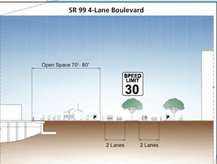
This one is said to be similar to Scenario A, but with more surface-street and transit improvements. (Delridge RapidRide is included in all these scenarios, as is the first West Seattle RapidRide route in the pipeline for 2011.) This also would suggest a “managed lane” on southbound I-5 from the heart of downtown to the West Seattle Bridge exit — that could mean HOT lanes like the ones people are now paying for on 167 in South King County.
Scenario C is subtitled “Alaskan Way/Western couplet”:

Powers explained this one as three lanes of Alaskan Way and three lanes of Western Avenue: “Northbound along the waterfront would be on Western Avenue and would be three lanes with a bike lane; southbound would be on Alaskan Way, three lanes with a bike lane.” This one would create a 110-foot wide strip of open space along the waterfront, according to Powers, more than the previous ones.
Now, the two elevated “scenarios,” starting with Scenario D, subtitled “4-lane elevated”:

Yes, “by definition, this is a viaduct,” acknowledged Paananen, while noting it’s four lanes side-by-side, not a double-decker like the current one. They haven’t discussed its potential height – maybe anywhere from 40 to 60 feet.
Scenario E, “4-lane integrated elevated”:

This one could also be nicknamed “the new viaduct you eventually will barely see.” More formally, it was described at the briefing as “one way of integrating the roadway with downtown in a way that makes it less visible as a transportation corridor” — because there would be buildings beneath it, and a greenspace lid over it. How much development might happen underneath it isn’t clear; Paananen said it would be evaluated block by block, with breaks for surface streets to get through.
Now the three underground options, starting with Scenario F, “4-lane bored tunnel”:
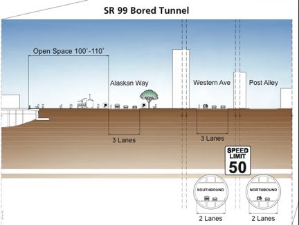
This tunnel with two “bores,” two lanes each, would start near Qwest Field and emerge just north of Battery Street Tunnel. “It’s a true bypass,” Paananen said. He added that it would have to be deep enough to go under the existing train tunnel, which could mean 100 feet or so; it would be about 2 miles long, and each “bore” would be about 43 feet wide.
Scenario G, subtitled “4-lane cut-and-cover tunnel”:

This may look familiar; it’s the closest thing on this list to the tunnel that voters turned thumbs-down on last year. “Tunnel light,” suggested one of our fellow media people at the briefing. “It’s a little bit narrower,” Powers was quick to point out, and has some differences — he says it’s “not built on a corridor solution” (in other words, it doesn’t completely replace what’s being lost with The Viaduct, and would include, like the others, surface and transit components).
Finally, there’s Scenario H, subtitled “4-lane lidded trench”:

This tunnel would be a little shorter than the other two; it would, like the others, have 2 lanes in each direction, but with openings in its cover “so that it could be ventilated naturally instead of with fans,” Paananen explained.
Again, those are just the key points. We don’t have time to go into all the details about the street and transit changes that are being considered with each option, but each has its own attributes, and we highly recommend clicking any of the scenario links above that intrigue you, so you can see the complete maps and legends; one big point of discussion at the briefing was the suggestion that another lane could be added to I-5.
Speaking of cars, a postscript – some of the transit fine print on the briefing documents mentioned Park-and-Ride lots in areas such as Burien and White Center. We asked Metro’s Ron Posthuma if there was any chance of a West Seattle P/R becoming part of all this. He indicated the city wasn’t particularly inclined in that direction, but, “we’re trying to get them to look at it.” The city, county, and state theoretically are equal partners in this process of replacing what will be lost when The Viaduct’s “central waterfront” section is gone, so if that is something that interests you, might be a good time to let elected officials know.
WHAT’S NEXT: As mentioned above, these scenarios will be “tested” over the next several months. Powers said that they may discover a component of one solution would work well if added to another, so the final versions may not be precisely like what is shown above — a “hybrid” could emerge. In the fall, they expect to narrow the scenarios down to three finalists, and then the final choice is to be made by year’s end. In the meantime, the Viaduct Stakeholder Advisory Committee continues to meet; local leaders continue to get Viaduct briefings, and a West Seattle-focused discussion is planned when the Southwest and Delridge District Councils have a joint meeting on September 3rd. In addition, a separate Viaduct project, the south-end work that is slated to start next year, will be the subject of a July 15th meeting at Madison Middle School. The state’s web info on all this, and more, is now collected at alaskanwayviaduct.org.
| 5 COMMENTS