Another closure: West Seattle Bridge bike path, starting Saturday

The West Seattle low bridge amd northbound 1st Ave. S. Bridge are already scheduled for closure this weekend. We just got word of another closure starting Saturday and set to last at least a week – this is from Sound Transit:

Beginning August 22, 2026, Sound Transit crews will conduct geotechnical work on the West Seattle Bridge bike path. Crews will drill a small-diameter hole and extract soil samples, then fill the hole and restore the surface area once the work is complete.

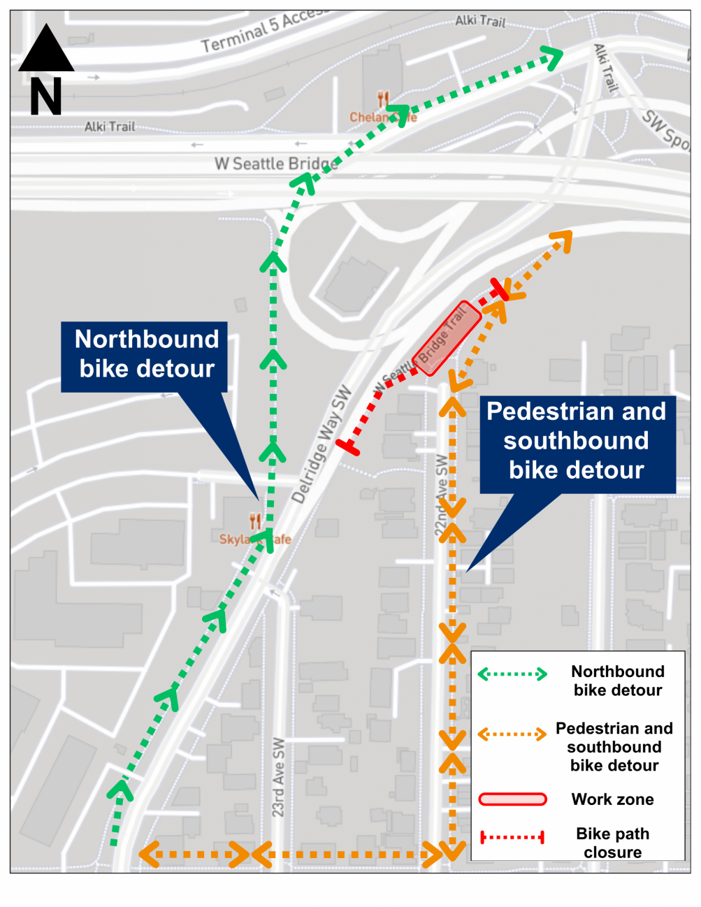
This work is expected to take about seven to eight days, and a portion of the bike path will be closed around-the-clock during that time. There will be a signed detour for pedestrians and cyclists in place. Please see the attached map for the detour route and closure area.

Nearby neighbors may hear construction noise during the daytime.

If you have any questions or comments, please contact the WSLE project team at westseattlelink@soundtransit.org or 206-903-7229. You can also contact the after-hours construction hotline at 888-298-2395.
This is in the path of the light-rail-only bridge that is to be built for the West Seattle extension – the complexity of which was cited as part of the reason the service is going to take three years longer than previously estimated, now set for a 2035 launch.

23 Replies to "Another closure: West Seattle Bridge bike path, starting Saturday"

  • Biker August 20, 2026 (3:33 pm)

    This map is confusing @SoundTransit. Many cyclists and pedestrians use the “southbound detour route” as both north and south routes from the low bridge. The map suggests that cyclists going north from pigeon point need to go all the way to Delridge to get onto the low bridge path. Is that correct?

    • Admiral2009 August 20, 2026 (4:52 pm)

      Biker the ST person is from the UK, they got the directions backwards!

  • Naomi August 20, 2026 (5:47 pm)

    The steepness of the orange detour route makes it a surprising choice for most non-e-bike riders. 

    • Foop August 21, 2026 (6:40 am)

      I think that’s the path to the 21st ave greenway path, it’s steep but fairly short. I ride this without an ebike daily. I’d still prefer a more direct bike route on Delridge but this is the scraps the city gave us who live on the south end of west Seattle.

  • JTinWS August 20, 2026 (6:42 pm)

    Not just snarking here: I sincerely hope the ST guys secure their equipment or better yet take it with them each night. The copper thieves are always busy along that stretch so I’m sure they’d love to swipe some expensive surveying equipment.

  • Admiral2009 August 20, 2026 (7:26 pm)

    The detour directing NB cyclists to use sidewalk adjacent to SB traffic is less safe.  Bicycle riders ride at a far greater speed than pedestrians and thus are vulnerable at intersections and driveways because they are going the wrong direction.  Bicycle riders riding on a sidewalk need to travel in the same direction of the adjacent traffic, it is safer.  

    • Mellow Kitty August 21, 2026 (9:41 am)

      It’s not just there. Electric bikes and scooters speed down a lot of sidewalks. Being a pedestrian in WS is a hazardous position. You’re dodging bikes, scooters and drivers. Few of them pay attention to their surroundings, even fewer look out for pedestrians. 

  • Earl gray August 20, 2026 (7:48 pm)

    They should have been working on the train years ago can’t believe that waiting till 2035 to launch that is a bunch of nonsense why is west Seattle last of the list for transit expansion everyone has already been waiting for a long time. Yet west Seattle ranks higher in sales tax and property cost than that a lot of other neighborhoods .  Dear golly does anyone really stick up for west Seattle anymore some how some way they are stealing time and money away from the west side

  • Nbrown August 20, 2026 (8:15 pm)

    Yes, map is a bit incomplete. My guess is that you use the lower bike pedestrian path approach from Alki Trail to and from low bridge unless you are coming from Pigeon Point or South which utilizes 22nd detour? Is that right? . 

  • Kathy August 20, 2026 (10:18 pm)

    I ride regularly on that green route between Alki and the Health Club. It’s a sidewalk much of the way. Ride carefully. Don’t ride “at a far greater speed than pedestrians”.  The cars coming off the West Seattle Bridge beside you are normally going like bats out of Hades. And be careful crossing that slip lane near the Chelan Cafe.

  • bolo August 20, 2026 (10:55 pm)

    Seems like I saw an electronic sign near this area stating the bridge will be closed (unpassable) this weekend?

  • Aaron G August 21, 2026 (9:01 am)

    I think whoever put this map together should have consulted someone who bikes through here regularly or a local advocacy group like West Seattle Bike Connections. This is not how I would have mapped out this detour. That being said, most regular commuters will know exactly what to do once they figure out what’s being closed here and it does help to know that it’s happening in advance. Signs were posted at key points when I came through yesterday. You couldn’t miss them. 

  • North Admiral Cyclist August 21, 2026 (10:04 am)

    I worked with maps my whole life and have ridden through this area on my bike dozens of times.  Still the map provided is confusing – as others point out.  First of all, many of us traveling to/from West Seattle and Downtown think of the lower level bridge route as east-west, not north-south (even though at points the route does run north-south).  So that reference throws me for a loop.  I wish they had a better map with more complete labeling and maybe the Google aerial as the base.    Clearly, good guide signing will be needed at every juncture.

    • WSB August 21, 2026 (10:33 am)

      I hope that someone has by now called the phone numbers provided to say the map needs clarification.

      • Kathy August 21, 2026 (11:57 am)

        Yes a couple of us called and emailed. Copy furnished SDOT. Others should do it too. This Green route is an area where we have been begging for safety upgrades from SDOT for years. Now it’s become critical, especially for new riders who are not aware of the safety hazards.

  • bolo August 24, 2026 (10:27 pm)

    I rode through this portion of the bikepath today AM and PM– it was not closed (Monday).

    • WSB August 24, 2026 (11:37 pm)

      Thanks. I don’t ride and can’t even try to verify on foot because of a logjam of things this week so I will just take it out of the daily reminders and hope that anyone who needed to know, knew/knows.

      • bolo August 25, 2026 (9:28 pm)

        Same for my AM and PM commute rides through this area on Tuesday– It was open, no barriers or obvious detour signage.

  • Nick August 25, 2026 (6:50 pm)

    I am confused. Always took the lower bridge to get over the Duwamish. Does the sidewalk that goes past the chelan cafe to connect to the main path to downtown. 

    • Kathy August 26, 2026 (12:34 pm)

      Not sure I understand your question. There is a sidewalk in front of the Chelan Cafe and the Alki Trail behind the Chelan Cafe. There is a crosswalk that connects to the Alki Trail across the north spur of Spokane Street (that becomes a ramp to Avalon Way/Harbor Ave). ST is proposing that cyclists riding northbound from the Andover/Delridge intersection use the west sidewalk of Delridge Way and the short trail to Spokane Street that is adjacent to the east side of NUCOR property.As of today I have not received any response from the West Seattle Link team to concerns I raised about the detour map and route. Riders report recently that while there are markings at the project site, the upper trail from the low bridge is not blocked yet.

Sorry, comment time is over.