New “West Seattle Walking Trails” map: Ready for its closeup

walkmapgrab.jpg

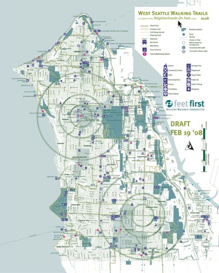
That’s a new map that could change your life, for the better: the draft of the first-ever West Seattle Walking Trails map, whose creators want to hear your take on it, before they draft the final version. (Click the image above, or this link, to download the whole thing as a PDF so you can zoom in to your neighborhood, your favorite walking route, or just to get a closer look at all of it.) One of the project ringleaders is the tireless West Seattle activist Chas Redmond, who explains what it is and how you can help with it:

Feet First, in partnership with Morgan Community Association, Delridge Neighborhoods Development Association, the Southwest and Delridge District Councils, The Southwest Historical Society, every community association here in WS and other organizations such as the West Seattle Junction Association and West Seattle Chamber of Commerce, present the first draft of the now-Climate Action Now program grant-funded walking trails map.

This is the first public review – folks should examine it, suggest changes – both additive and subtractive. There will be a second draft based on the comments of the first draft. SDOT will have the final review and there will probably be some changes from that resulting in a – final – third draft.

In the meantime, the back side of the map – which will include write-ups on every neighborhood and organization and signature interest point – will hit the streets. Probably two weeks from now we’ll have the text draft, which will coincide with the closing of comments for the first draft. The back side review will also include a second review round.

Folks should comment not only on the trails, the evolution of which can be learned by reading the contents of westseattlewalks.org, but also on the use of symbols, the correct location of schools and parks (we’ve checked, always helps to triple check), the color scheme (we’re limited to two colors to get max number of copies), and anything else.

Within a month or so we’ll have 20,000 copies of this map, which will be folded to a size about like a Metro route schedule. We have a complex and involved distribution scheme which should allow everyone in WS to at least have access to a copy. Eventually we’ll reprint in larger numbers, but want this first version to not only serve the neighborhood, but serve as a learning tool for what an urban wayfinding system and info tools about such a system might be like and how they might be better. A year of using this map will teach all of us – including the users – a whole new dimension in getting around – we hope, anyway.

Here’s the link again to take a close-up look at the map as a PDF (using zoom if you choose). As Chas mentioned, there’s a lot of backstory on the parent site for that link, westseattlewalks.org – once you’ve reviewed the map, Chas asks that comments be sent to him (credmond@mac.com) and Feet First’s Seth Schromen-Wawrin (seth@feetfirst.info).

26 Replies to "New "West Seattle Walking Trails" map: Ready for its closeup"

  • steveed February 24, 2008 (3:12 pm)

    Great map, but I wish they had used Vector Art in the pdf for infinite zooming.

  • chas redmond February 24, 2008 (5:09 pm)

    Steve,
    The final, distributed, version will have a companion PDF which is vector art. In the interests of time we’ve gone with JPG and PDF for review. The PDF will zoom in to the actual size of the printed map, which is 25×22 inches. Legibility at this size is also a concern to us. We’re using ArcView and Illustrator so your vector version will be available once everyone has had their say.

  • Forest February 24, 2008 (5:11 pm)

    CORRECTION: Fairmount Avenue Ravine, which passes under the Admiral Way Bridge is not a city park. It’s a second growth greenbelt and, except directly under and around the bridge, a majority of it is owned by adjacent private property owners, not the city.

  • chas redmond February 24, 2008 (6:03 pm)

    Forest,
    Thanks. We might modify the language to indicate green space. There’s even some question as to what “is” a trail. Is a sidewalk a trail? Is walking down a super-low traffic asphalt stretch of street a trail? To someone walking by a vacant lot which has some degree of native growth, that may appear parklike even if it’s not. To some degree, the visual experience of a walk is not directly tied to some things like ownership. So in a sense, even though Fairmount ravine is entirely privately owned save a few parcels here and there, the overall environment is actually very park-like.

    Raises a good question. Got a suggestion as what to call those kinds of areas?

    It also points out that the world of the pedestrian is only now beginning to get the same close inspection the automobile and more recently bicycle have gotten in terms of engineering and descriptive language. The concept of urban wayfinding is still pretty new. We’re sort of breaking new ground here and new ideas are wanted and solicited.

  • Eric B February 24, 2008 (6:52 pm)

    Well, it already gotten me out. I had looked for a way down the bluff between Spokane/Charleston and Hudson when I first moved here almost 3 years ago. I never found a way. Thanks to the map I just had a lovely sunset walk on the trail from the end of 55th into Me-Kwa-Mooks. Wonderful!

  • SLK February 24, 2008 (6:53 pm)

    What a cool idea! I walk in the Alaska Junction, Admiral & Alki areas a fair amount. I had that same question about what is considered a trail, and why some sidewalks are considered trails while others aren’t. I think it would be very helpful to make sure the names of the trails/streets/sidewalks are clearly labeled on the map, close to where someone might be looking for a street sign. (examples are Ferry, California where it meets Harbor, the E-W portion of Bonair near California). I still sometimes worry in less familiar areas that I am climbing a steep hill that is just going to dead-end instead of taking me where I’m trying to go! I checked out the website, and it looks like there will be some kind of trail markers/signs, so that will definitely help.
    Some of trails on the map appear to dead-end, like the trail coming out of Schmitz Park at Hinds (which I know is a street but could be considered a trail to create a connection to 49th or to California), and whatever is shown to the east of the base of Fairmount (it looks like it is labeled SW Bronson Way – I’ll have to check that one out – does it actually connect from Harbor to Fairmount?). Given my fear of being stuck on a hilly trail-to-nowhere, I’d prefer to see the trails be continous.
    Maybe it would be helpful to have some kind of symbol for hilly sections, so people looking for a more level walk could plan accordingly.
    I’ll keep my eyes open and send more specific comments to Chas & Seth directly. I’m looking forward to exploring some new neighborhood routes!!

  • Alvis February 24, 2008 (7:41 pm)

    Contrary to the map symbols, Hiawatha Playground/Park doesn’t have swimming facilities. It has an outdoor wading pool that is closed nine months out of the year.

    Also, business districts and grocery stores are important for walkability purposes, and ought to be indicated, whereas the locations of private medical and dental clinics, or flexcar parking lots, have little or nothing to do with walking.

  • chas redmond February 25, 2008 (12:26 am)

    The shopping areas will be a little more obvious once we get the text portion (the back side) ready for review. The shaded areas indicating urban villages should also be identified in the key as locations of shopping and eating. Good points, Alvis. The Flexcar identification needs to change (it’s Zipcar now), but locations of bus lines and other public conveyance elements have consistently been requested, including the location of carshare vehicles.

  • Mikev2.0 February 25, 2008 (9:32 am)

    I don’t think highland park has an actual swimming pool either. I believe its a wading pool.

    It would be nice if “primitive trails” were a different color from paved trails. I had a hard time distinguishing. I’d like to be able to find wooded paths where I don’t have to listen to dogs barking at me and cars roaring by.

  • me too February 25, 2008 (9:35 am)

    Great map. I live near 35th SW, and I had trouble identifying it. I think it needs more identification labels, like California Ave has, since it’s a primary arterial. I was also surprised that the 21 bus route that runs up and down 35th was left off the map.

  • lala February 25, 2008 (10:04 am)

    What’s “The Old Mud Hole”? I guess I live really close to it and have no idea what it is.

    This is a great idea. Can’t wait to see the final!

  • Dawson February 25, 2008 (11:34 am)

    I can’t get any of the links to work for the map. Seems to come back with a message the file is damaged and can’t be repaired.

  • old timer February 25, 2008 (12:13 pm)

    “the locations of private medical and dental clinics, or flexcar parking lots, have little or nothing to do with walking.”

    Unless you are trying to determine if it’s walkable, or worthwhile to walk to your doctor, dentist, or zipcar from wherever you’re starting from.

  • Forest February 25, 2008 (12:27 pm)

    Like the Water Taxi map, which suggests it would be easy to roller skate between neighborhoods, this map fails to communicate that West Seattle is NOT a nice flat walking surface. Is there some way the map or its legend symbols or a sidebar text could clarify major elevations changes between one destination and another? For example how would a visiting walker know that the Alki area is effectively isolated from the nearby Admiral area by the hill climb to California Avenue SW?

  • Bob February 25, 2008 (1:45 pm)

    This is a great idea. But the entire map should be based on a topographic map. The kind with iso-lines clearly marked in feet above sea level, not the vaguely shaded kind.
    .
    Before you make a second draft, please look at the old walking safety maps that used to show the safer, preferred walking routes to schools in each neighborhood. Maybe they still make them.
    .
    On this draft, it’s hard to quickly locate many of the dashed lines and other relevant detail when scanning the map, because of the camouflage created by the welter of building footprints. Building footprints should be used only for landmark structures.
    .
    Everything here is in such similar shades of pastel that it’s hard to recognize some features without close scrutiny. Use more contrast, and use equally big type for all the street names.
    .
    The big bullseyes aren’t as useful in steep areas full of streets that don’t go straight through. The important thing in those areas is to clearly see which streets do connect. But the actual streets are almost invisibly thin here, and in many cases I just can’t tell from this map which ones do and which ones don’t. My 2001 Rand McNally Seattle map is wrong about that for two places that I know of, where they show the streets connecting. They almost do, but there’s a steep embankment and they actually don’t. Neither can you walk between them. Of those two, your map does show that one of them doesn’t connect, and for the other it doesn’t show enough to figure it out one way or the other, even with my magnifying glass.

  • jai February 25, 2008 (3:18 pm)

    Great work! Can’t wait to get my hands on the final copy.

  • chas redmond February 25, 2008 (3:23 pm)

    Thanks so far for everyone’s comments. We’ll be compiling the comments and suggestions and working on draft version #2 soon. The window for this version is now through March 10. We’ll be making changes as we go and hopefully will have a second review version out on/about March 10. In the meantime, keep you eyes out for a draft of the backside which will feature text descriptions of the neighborhoods, business areas and cultural/recreational/educational facilities.

  • Sue February 25, 2008 (6:26 pm)

    I would suggest that the circles that show how many minutes the walk is, be amended to show how many approx. miles instead. Everybody’s got different abilities, and I there’s one part of the map that claims it’s a 5 minute walk from one point or another that I know takes me considerably longer than that.

  • Bob February 25, 2008 (7:39 pm)

    It shows 5 minutes for 4 blocks or 1/4 mile. That’s 20 minutes a mile, 3 mph. In the ’50s I walked at 4 mph, and figured distances that way to see where I could get and back during a 1 hr lunch. Now, 1.5 mph might be pretty close, and certainly less than 1 mph uphill. It’s been years and years since I’ve been up any of the long stairstep streets, and it might be 1/4 mph for those now if at all. This map really needs to show elevations – because this isn’t Kansas, Toto.

  • Susan February 25, 2008 (8:26 pm)

    What a great idea! It took forever for my DSL to boot up the pdf, but I was glad it did. This will definitely expand my walking horizons. A couple of suggestions: major arterials are quite hard to identify – especially Fauntleroy and 35th. Also, while the building still exists, Fairmount Park Elementary is no longer a school. And isn’t it the Fairmount neighborhood, not Fairmont? Just quibbles, really. Can’t wait to see the finished product.

  • chas redmond February 25, 2008 (11:15 pm)

    Susan,

    Thanks. Nothing is a quibble. Really, we’re looking for any major or minor thing which we can improve. What makes projects like this work is the interactive community element – we’re it! Legibility issues have come up often, we’ll be addressing that. Symbols are one of those art/craft/science things and we’re learning as we go. Proper and correct nomenclature and names are definitely key components of a useful tool. All good comments.

    I do apologize about the size of the files. For a choice, here’s a link to a download site which has the JPEG and PDF versions of this file – “homepage.mac.com/credmond/FileSharing101.html.
    Some browsers may indicate an error in opening the map, ignore the error and download and view the file – the file isn’t corrupt. Can’t quite figure my way around that particular glitch, hopefully it isn’t affecting a lot of folks.

  • WSB February 25, 2008 (11:37 pm)

    Maybe this is why a couple people running 1.0 versions of Safari wrote me today that WSB was suddenly crashing their browsers. A good reminder to keep your browser updated, whatever you are using – and even if you have an older Mac (ours is at least 3 years old), you should be able to do the browser upgrade (our version of Safari is 3-point something, though we do prefer Firefox).

  • Steve Klinkel February 26, 2008 (7:42 pm)

    Hi, Love the Map! couple suggestions, I would consider going to a little brighter green color for the trails they tend to blend in a little because of the amount of green indicating the homes, I would also consider a tone change in addition to the line thickness on the primitive trails as well, the buisness district and parks indicators on the legend are odd I would stick to color only to differentiate, again I feel allot of the other lines tend to get lost because of the color similarities, rather than incorporating any topographical info on another layer of this map I would condsider a completely different window with elevation only, the map would be way to busy I think?

    Hope my suggestions help

    Good work!

  • Aaron March 1, 2008 (9:11 am)

    Everyone seems to be leaving feedback here, so hopefully Chas will see this…

    Constructive Critique:

    Remove all of the residential home footprints mentioned in an earlier comment. They add visual clutter to the map and don’t serve as a valid point of reference. City blocks, a la Google Maps, would be of greater use. This map is all about getting from point A to point B on foot, not finding your friend’s house.

    The map key indicates that both parks and business districts are indicated by dark teal areas. Consider using green to indicate business districts and teal for parks (or vice versa).

    Consider using your two colors (and tints of those) to give the map visual hierarchy. E.g, bolder colors indicate routes, tints indicate areas (such as business districts or parks).

    Speaking of colors, this is not an accurate representation of a two color print, unless you have magic inks that create magenta when teal and green are mixed :)

    Not all bus routes are shown, so some explanation should be indicated in the key such as “arterial bus routes” or “bus routes serving business districts”. 55? 21? Great routes such as these can get a person from WS to Ballard, Greenlake, and farther without making a transfer.

    Bike routes are quite difficult to see. Try reversing the dashed line to white when it is shown on top of a roadway. Also, indicate local bike shops and bike rental locations!

    Hope that helps. It’s a great concept and I look forward to seeing it come to fruition!

  • erincorrine June 4, 2008 (1:33 pm)

    THANK YOU THANK YOU THANK YOU!!! I moved here a little over a year ago and have been looking for this ever since! You will make my daily walks so much more productive! Can’t wait for the hard copy.

    Erin

  • Will on 56th June 4, 2008 (4:04 pm)

    FYI

    I picked up a copy at the Alki Mail & Dispatch for those looking for a hard copy.

Sorry, comment time is over.