FOLLOWUP: Cleanup, road repairs, investigation continuing at West Seattle slide scene

bottomofslide
(WSB photo)

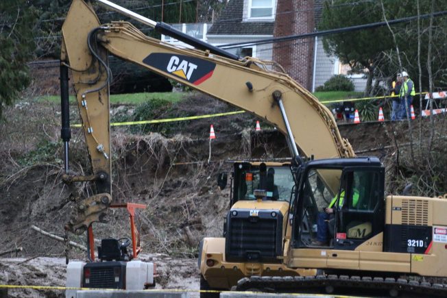
As the day came to a close, Seattle Public Utilities crews were on both sides of the Fauntleroy slide – up on the dead-end section of California SW where part of the road itself washed away late last night (WSB coverage here), and down on the SW Cambridge street end, which is what you see in the next two photos, sent by Jeff VanGilder:

20170120_125540

SPU spokesperson Katie McVicker told WSB they still don’t know why the 2-inch water line broke. Two customers were without water this afternoon, with others on California SW likely experiencing lower-than-normal water pressure, but SPU expected service to be fully restored tonight. As for the road, we asked SDOT’s Sue Romero:

SPU is taking the lead on the cleanup efforts. Currently, the west side of the street is impassable due to damage, however, there is enough room to keep one lane open to allow local access to residents. SDOT is continuing to support SPU efforts. We are working to add sand bags to divert any surface water from the undermined/washed out area.

We will continue to monitor the anticipated weekend rain. There is a possibility that we may need to close the road to vehicle access if the road is further undermined. If that occurs, we would assess and determine if it would be possible to provide pedestrian access to homes. Any final restoration and mitigation measures proposed by SPU’s team will be reviewed and approved by SDOT.

And then there’s the question about safety of structures in the area.

20170120_125500

Seattle Department of Construction and Inspections spokesperson Wendy Shark said inspectors had been sent to check out “buildings” in the slide area, but by day’s end she hadn’t heard back on whether they had needed to take safety action, so that’s information we might not get before Monday.

6 Replies to "FOLLOWUP: Cleanup, road repairs, investigation continuing at West Seattle slide scene"

  • ACG January 20, 2017 (11:19 pm)

    I saw the slide area today. That was a lot of dirt that gave way. I’m trying to wrap my brain around how a 2 inch water line leak could cause that much land to move. The pictures really don’t do it justice to gain perspective on how much land gave way. Anyone have any numbers or calculations to help me see how that is possible? Should have paid more attention in physics class, I guess. I would have thought it was a much bigger diameter line for the amount of dirt and debris that slid.  My thoughts are with all the folks affected. Yikes, that must have been terrifying in the middle of the night. 

    • Tbone January 21, 2017 (7:58 am)

      How that is possible is that the water seeps down to a layer where the ground is less permeable.  So you have a large, thick, saturated (thus heavier than normal )mass sitting sitting on top of a surface that keeps losing friction as the water spreads out, since it can’t go down any more.  Sort like how snow slides off of a metal roof once the temperature changes enough for the contact area to turn into a liquid.  The depth of the soil and the impervious area varies a lot – it could be 20′ deep or more.  Virtually all of west Seattle is classified as a potential slide zone because it’s basically a big heap of silt and sand sitting on top of more stable soils, due to glacial activity

      • ACG January 21, 2017 (1:18 pm)

        Thx, T bone- that explanation helps make sense of the event!!

        • Tbone January 22, 2017 (2:50 pm)

          You’re welcome!  It is amazing what a ‘small’ leak can do!

  • EllenP January 21, 2017 (9:10 am)

    Thanks on reporting this WSB!  Will this project be “exposed” anywhere on the City’s website?  Like their big projects here: http://www.seattle.gov/util/EnvironmentConservation/Projects/index.htm

    • WSB January 21, 2017 (10:07 am)

      Well, right now it’s an emergency response, not a project.

      Re: cause, nothing has been said so far other than water break, followed by slide. The cause of the water break itself is still under investigation. The slide itself is in public right of way – the road and embankment there between the dead-end of Cambridge and the side of California SW. (If you follow the map link, you’ll see the spot.)

Sorry, comment time is over.