West Seattle, Washington
24 Wednesday
-Major car ice (no surprise since temp’s in the 20s); prep your scraping arm.
-Looks like another morning moonset in the making (big bright full moon in the western sky now).
We do, anyway. Two photos e-mailed to WSB earlier this week and held for when a “virtual sunbreak” might be in order (like now!):

That one’s from RPH, who took it while flying in on Tuesday. Next one’s from Bob Bollen, during Wednesday’s sunset:

Thanks to RPH and Bob!
The clouds have moved in over the top of the Olympics now, so we’re glad to have snagged this video view just for fun while out and about this morning.
Major ice on the car, so if you don’t have a garage to park in, you’re likely to need some scraping time. Looks like all the school delays are to the east and north. Same with the Metro changes. Forecast: Clear, cold day. Check traffic cams here.
While out for a walk a little while ago, we were passed by a car with slushy snow all over its hood. That gave us the hint it’s snowing somewhere not too far away; My Ballard, Central District News, and Seattlest verified that. Looking at the latest National Weather Service “forecast discussion,” doesn’t sound like it’ll get this far south. However, road ice could be a problem in the morning, the city warns. And Metro just sent this advisory about possible bus-service effects. Here’s the school-status link to check if you’re up mega-early.
In case you missed the spectacular sunbreaks while, oh, say, indoors watching The Game … above, we present a snippet of video from Beach Drive, as the sun held court over Vashon. Below, we dropped by the Pigeon Point Park environmental-restoration work party (video preview here) and while the Nature Consortium folks and their volunteers were just getting going, we found artist Aaron Voronoff already well into the process of making an ever-evolving sculpture out of trash and plant debris that work-party participants were collecting:
Voronoff’s creation was to be disposed of later, by the way. The Nature Consortium tells us that most of its work parties feature environmental entertainment like this, with artists, musicians, etc.
Five beautiful photos from WSB contributing photojournalist Christopher Boffoli, capturing the rare sighting of the sun. First – driftwood and surf along Beach Drive:

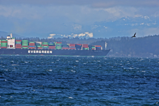
A freighter heads north, with the snowy Olympics peeking through the clouds in the distance:
Heathers in bloom on Beach Drive:

A cormorant keeping watch atop a piling:

And the troubled (but lovely, we think) steel-electric ferry Quinault, one of the 80-year-old ferries that the state is ready to scrap because of their hull problems:

Forecast suggests this may be the last we see of the sun till sometime Sunday.
There’s some on the car roofs up here on our hill, but not on the road. How about you? 6:30 AM ADDENDUM: No delays or changes reported for Seattle schools; if you need to know what’s happening at schools out of the area, here’s the regional list. 6:45 AM: Adding this photo from the parking strip nearby. Our resident snow expert describes what’s on the grass as “thick, a little bit frozen, slush” but even up here what’s coming down is just light rain; thermometer (note we have one in the right sidebar of this page now too) says 35.

No further snow in the forecast – at least as of right now.

Look closely just past the white sheeting in this photo – you’ll see the rootball of a toppled tree that we noticed is drawing some doubletakes as it rests precariously on the slope where California Way meets Harbor near Seacrest (map).
If not today, perhaps tonight, says the National Weather Service‘s latest “forecast discussion.” (When they talk about the 500-plus-foot hills, note that only one area of the city really cracks that level, and it’s right here in West Seattle (as listed on the city’s “highest elevations” page, which also lists the streets with the steepest grades.)
Top-of-the-hour weather conditions from the National Weather Service include gusts up to 38 mph at Alki Point (K91S, in this roundup). (ADDED 10:30 PM: Here’s the Beach Drive weather station page, thanks to BDB.) The latest “forecast discussion” also mentions snow levels potentially as low as 500 feet on Saturday night, which means a big temp drop at some point, considering it’s upper-40s out there now. ADDED 11:07 PM: Top-of-the-hour gust at Alki Point now listed at 50 mph. No power outages right now but if anything major happens, here’s the City Light page that will list them. ADDED 12:27 AM: First “flickering” here in Upper Fauntleroy – the wind’s just intensified, too. ADDED 2:07 AM: 51 mph for the Alki Point top-of-the-hour gust, this time.
Kicks in this afternoon, according to the latest forecast.

Thanks to Marco in High Point for e-mailing this photo of Lincoln Park in today’s glorious sunshine.
On this breezy Friday morning, Bob Bollen just sent this great photo to share (thank you!):
This is why we love the National Weather Service “forecast discussions” more than the forecasts themselves … the brutal honesty. This, from the “discussion” posted by the NWS moments ago:
SHORT TERM…WELL THIS EVENT DIDN’T PAN OUT AS WELL AS I WOULD HAVE HOPED. 1 TO 3 INCHES OF SNOW HAS BEEN REPORTED OVER THE HOOD CANAL AREA THIS AFTERNOON…WITH LIGHT COATINGS OF SNOW IN PARTS OF SNOHOMISH COUNTY…EASTERN KING COUNTY AND THE CENTRAL COAST. HOWEVER OUTSIDE OF THAT…BASICALLY THE REMAINDER OF THE AREA HAS SEEN A VERY LIGHT RAIN/SNOW MIX AT BEST. THIS SYSTEM DIDN’T PRODUCE HEAVY ENOUGH PRECIPITATION TO SNAP IT OVER SNOW AND ACCUMULATE. A DECENT SOUTHEAST COMPONENT TO THE LOW LEVEL WIND FIELD IS ALSO HAVING A DRYING AND WARMING EFFECT FROM THE CENTRAL SOUND AND AREAS TO THE SOUTHEAST. BACK EDGE OF SIGNIFICANT PRECIPITATION IS NOW MOVING INTO THE PUGET SOUND REGION SO THEOUGH 4 PM MANY AREAS MAY SEE A BURST OF SNOW SHOWERS FOR A BRIEF PERIOD…BUT ACCUMULATIONS OUTSIDE THE HOOD CANAL UNLIKELY. WILL BE PULLING THE SNOW ADVISORY OUT OF MOST OF THE LOWLANDS WITH THE EXCEPTION OF THE HOOD CANAL AS IT IS STILL SNOWING AND ACCUMULATING THERE.
Light snow, starting just before 9 am, on target with what the Weather Service predicted last night. Be careful out there. Send pix if/when it sticks.
The National Weather Service has a Snow Advisory up for the whole metro area; the latest “forecast discussion” (which will be updated in a few hours) suggests the snow’s likely to arrive in our area between 7 and 9 am, but shouldn’t get really intense till afternoon.
The snow shower here in Upper Fauntleroy is pretty serious … if this goes on much longer, it just might stick. We’ll post any pix we get (or just leave a comment with the report from your part of town … already got e-mail from Westwood noting snow there too). 2:37 PM UPDATE: Looking south down California, you can see the dusting on cars & roofs:

And this photo just in (thank you & Merry Christmas!) from KA at California/Webster on Gatewood Hill:

3:05 PM NOTE: It’s almost stopped here. Just in time for Christmas dinner! 3:45 PM UPDATE: National Weather Service forecast is updated. “Light coating of snow possible.” 4:55 PM ADDENDUM: Thanks to SO near The Junction for this festive, snow-coated photo:

The forecast only called for 10-20 mph wind (at least as of this writing). But it sounds a lot stronger than that out here in west-facing south West Seattle, and indeed, according to this real-time Beach Drive station, it’s in the 30s right now, with gusts into the 40s.

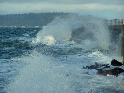
… unless you count seaspray, such as that seen in the pictures above and below, taken by Jason Parker (thanks!) at Constellation Park. Forecast looks cool and showery. But you never know.

A sudden gust rocked the house and sent us to the National Weather Service forecast updates – where we found a wind advisory in effect for the metro area tomorrow, 4 am-4 pm, south wind with gusts possible up to 45 mph.
We were wondering if anyone was going to notice that tonight’s the anniversary of last year’s big windstorm. King County noticed, at least. On December 14 of last year, we mentioned the pouring rain at 5:22 pm … then the howling wind, at 11:28 pm. If you want to relive the (non-) joy of the ensuing days and nights of powerlessness, cleanup, and repairs, pick up our archived coverage (in reverse chronological order) here. Tonight’s forecast, meantime, looks like a breeze in comparison. 10 PM UPDATE: City Light issued a “windstorm anniversary” news release tonight touting changes made since last year – here’s the full text, since we can’t find it anywhere on the city website so far:Read More


| 1 COMMENT