West Seattle, Washington
09 Tuesday
1:49 PM: The snow has stopped – or at least paused – but temperatures are dropping, so what we have is likely to linger. Here’s our previous coverage; now we’re launching an afternoon report for weather-related info/updates. General advice remains, if you have to go out, avoid hilly streets – that’s where most of the trouble has been reported.
WEATHER/TRAFFIC RESOURCES (updated 4:13 pm)
National Weather Service (current alert expires at 2 pm)
SDOT Winter Weather Response map (where streets have been plowed/sanded/salted and how recently)
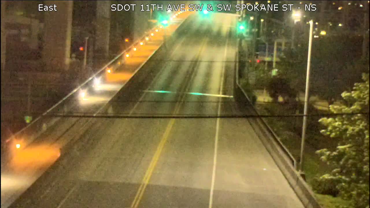
West Seattle traffic cams
Citywide traffic cams
King County traffic cams (choose “south” tab for White Center)
Metro on snow routes and has as of late afternoon suspended routes 55, 56, 57, 125
OTHER CLOSURES/CHANGES (updated 3:36 pm)
Residential trash/recycling collection delayed one day
Senior Center of West Seattle closed
Community School of West Seattle closed
South Park Library closed
SPL update: All neighborhood library branches closing at 5 pm
If you have anything to add, from a road report to a business/event change, westseattleblog@gmail.com or text 206-293-6302 – thank you! Updates to come.
2 PM: Deep puddle reported in the southbound lanes of the 1900 block of Harbor SW; city crews have been notified.
2:58 PM: No further snow, but the temperature’s below freezing. … One note from the WSB West Seattle Holiday Guide – we’ve reconfirmed that the reindeer and Santa/Mrs. Claus appearance at Menashe Family Lights (5605 Beach Drive SW) 5-9 pm tonight IS still on.
4:11 PM: We’re continuing to add updates to the lists above but wanted to note this here too: Metro has just officially suspended routes including West Seattle’s 55, 56, 57, and 125 for the PM commute period.
5:15 PM: No traffic problems reported in the area, and no new snow, but it’s icy. Tonight’s low is expected to be in the 20s; tomorrow’s high might not even make it to 30; and the Wednesday night low could drop into the teens. But by Christmas Eve – rain and almost 50.
With trucks getting stuck on hills as mentioned in our weather coverage, it’s no surprise that this was just announced by Seattle Public Utilities:
Due to winter weather conditions, there will be delayed residential garbage, recycling, and food/yard waste pickup in Seattle for customers in Seattle today, Tuesday, Dec. 20 through the rest of the week. SPU’s Haz Waste sites and stations are closed to customers today, Tuesday Dec. 20 and will attempt to reopen tomorrow, weather permitting.
Weather and road conditions permitting, garbage, recycling, and food/yard waste service will resume Wednesday, December 21, 2022 on a revised schedule — with customers scheduled for pickup today, Tuesday, collected tomorrow. All remaining residential services will be delayed one day this week. For example, if your regular collection day is Friday, your garbage, recycling, and food/yard waste will be collected on Saturday this week. Customers should be sure to have their containers out by 7 am to ensure collection.
If your materials are not picked up by the end of the following day, please put them out on your next regularly scheduled pickup day. Customers missed this week will be allowed to set out double their normal amount of garbage, recycling, and yard waste at no additional charge, on their next scheduled collection day.
(We’re updating this story through the noon hour and will switch over to afternoon coverage after that – scroll down for updates)
9:44 AM: Thanks to Debra Salazar Herbst for the tip and photo from Alki – it’s snowing in north West Seattle.

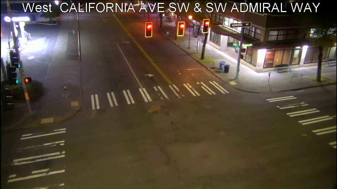
Here’s the “live” image from the California/Admiral traffic cam:
9:59 AM: And now it’s turning to mostly snow here on the Gatewood/Upper Fauntleroy line.
10:19 AM: Metro says all buses are now on snow routing.
10:32 AM: SDOT is out – we’ve heard a plow truck just around our corner, and the SDOT Winter Weather Response map verifies where they’ve been most recently. Reminder if you’re new, they don’t plow side streets – just pre-designated main routes (also outlined on the map, as well as here). Meantime, Caity Gerhardt sent this photo from Highland Park:

Photos always welcome – westseattleblog@gmail.com or text 206-293-6302 – thank you! … Traffic report: 35th/Hudson treacherous, per SPD dispatch saying SFD is asking SDOT for plow attention there.

11:01 AM: Thanks for the photos from Sylvan Way, where things are bollixed right now, with a stuck trash/recycling truck among other problems. The photo above is from Sam, who’s trying to get to her Junction shop Fleurt to open it for the day but is stuck on Sylvan. … Where we are, the snow has stopped for now, so perhaps SDOT will be able to catch up with trouble spots soon.
11:17 AM: Texter reports that “Highland Park hill is super-icy and several cars pulled over, having to turn around. Several cars are stalled on the hill as well.” … Update from Sam on Sylvan Way: “The truck driver stuck in the ditch has been directing traffic. Sylvan Way is down to 1 lane, somewhat passable right now when people drive on the curb,” though it’s still “really backed up.”
11:29 AM: Update from Sam – SDOT sanded Sylvan and pushed the dump truck out – both lanes now open. … Weather update: NWS has now shortened the Winter Weather Advisory to expire at 2 pm, so they’re not expecting much more snow. … Our Highland Park Way tipster says the hill’s just been closed and that a solid-waste truck’s stuck there.
12 PM: Kersti Muul reports a truck vs. pole crash at 47th/Admiral.
12:25 PM: As published separately, SPU has now announced solid-waste pickup is a day delayed this week. Also: Community School of West Seattle is closing and asking families to pick up their kids. In The Junction, Fleurt is now open, and reporting that Menashe & Sons Jewelers and CAPERS also are open, if you can get out to shop safely – shop local! … The traffic camera at the bottom of Highland Park Way hill shows it’s at least partly reopened.
===========
Earlier:
6:02 AM: Good morning! It’s Tuesday, December 20th. The weather alert was downgraded overnight to a Winter Weather Advisory – not so snowy after all, at least in Seattle.
WEATHER
Today’s forecast as a result: Rain/snow mix more likely than outright snow, high in the upper 30s.
TODAY’S TRANSIT STATUS
–Metro is still down buses for repairs and is suspending some routes again today, but as was the case Monday, no West Seattle routes were on the initial list. Keep watching notification channels such as @kcmetroalerts for trip cancellations and route suspensions. (Also, no snow routing anywhere in the county. 10 AM UPDATE: Some reroutes in all areas – follow that same link to see if your bus is affected.)
-The West Seattle Water Taxi is on its regular schedule.
-WSF’s Triangle Route remains on its two-boat schedule- check here for alerts/updates.
STREETS & SPOTLIGHT CAMERAS
(Just for reference, here’s the SDOT Winter Weather Response map – nothing going on this past hour.)
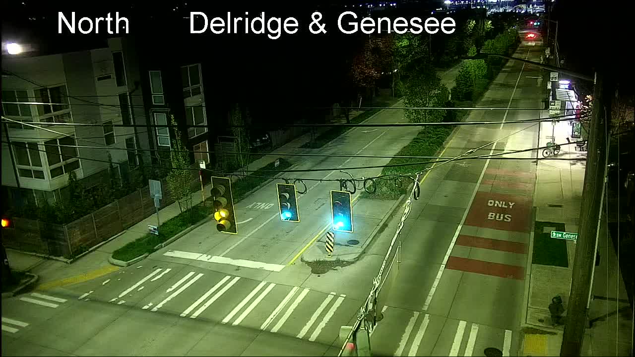
New Delridge cameras: As reported here, three have been added; four more are on the way. Besides the one below (Delridge/Genesee), cameras are also up at Delridge/Oregon and Delridge/Orchard.
High Bridge – here’s the camera at the top.
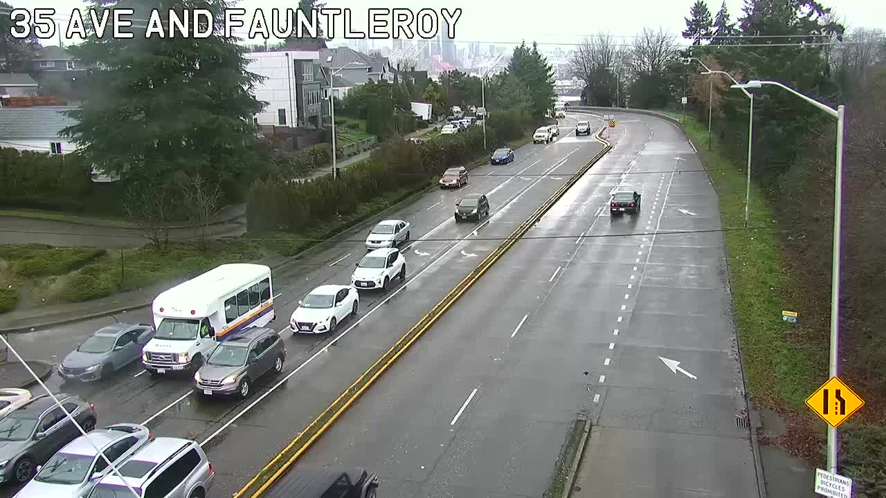
High Bridge – the view from its southwest end (when SDOT points the 35th/Avalon/Fauntleroy camera that way).
Low Bridge: Or nearby, depending on where SDOT points the camera.
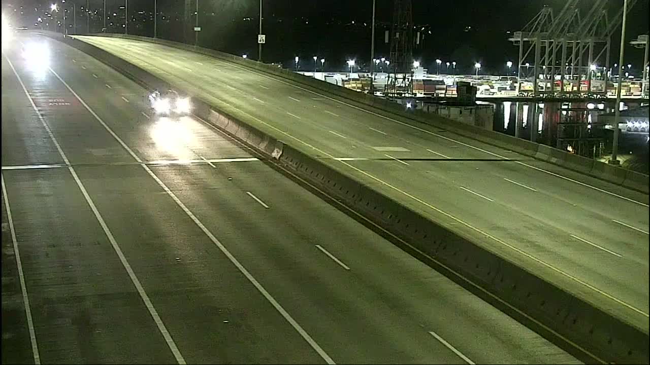
1st Ave. S. Bridge: The south route.
Highway 99: Here’s the northbound side at Lander.
All functional city traffic cams can be seen here, most with video options; West Seattle and vicinity-relevant cameras are also on this WSB page … Are movable city bridges opening for vessels? Check the @SDOTBridges Twitter feed.
If you see a problem on the roads/paths/water, please text or call us (when you can do so safely) – 206-293-6302.
 (Photographed near Me-Kwa-Mooks by Patricia Boiko)
10:05 AM: As reported this afternoon, a Winter Storm Warning is now in effect for our area, and that could mean several inches of snow by morning. Many areas still have some lingering from the weekend; today’s high only reached 34 (12 degrees below normal) so there wasn’t much melting. With the anticipation of potential overnight snow, we have a few announcements in already:
–Senior Center of West Seattle will be closed Tuesday
–West Seattle/Fauntleroy YMCA (WSB sponsor) plans to open late, at noon Tuesday
-If you have Tuesday solid-waste pickup, Seattle Public Utilities tells us they’ll be making their decision early in the morning, once they’ve assessed safety; if there’s a change, they’ll announce it here (we’ll have the info too)
–SDOT‘s out treating roads – this map shows where
-Citywide traffic cameras (with still image and video options) are here
–Metro is on regular routing as of right now
If you have changes, announcements, info, pics, please email westseattleblog@gmail.com or text 206-293-6302 – thank you!
5:45 AM: We’ll launch the usual morning traffic coverage shortly, but first a note that the alert was downgraded overnight to a Winter Weather Advisory – less potential snow.
–
 (SB 35th SW near Providence Mount St. Vincent)
12:11 PM: We’ve been out all morning covering two stories outdoors (details later), but wanted to share one observation in case you’ve been trepidational about going out – our side street was snow-coated when we returned between events an hour and a half ago, and now it’s mostly clear, so there is some melting happening. The arterials have been clear all along. SDOT crews have been out the past few hours – here’s the map that shows you where they’ve been and when. Meantime, the National Weather Service now has Seattle (among other areas) under a Winter Storm Watch alert starting at 7 pm tonight and lasting through Tuesday.
2:53 PM: The alert is now upgraded to a Winter Storm Warning – up to 8 inches of snow possible, but it may not last long, as the alert also mentions a possible transition to rain “across King County.”

6:18 PM: The first snow showers have arrived in parts of West Seattle. We were just in The Junction and Alki, where what was falling ta the time was more like cold rain, but as we drove south into High Point, Westwood, Gatewood, and Upper Fauntleroy, we saw a dusting of snow on cars and planting strips. The National Weather Service forecast has chances of snow off and on for the next few days, though nothing massive is expected so far. Are you seeing snow too?
7:03 PM: Still snowing lightly up here but radar suggests this will all end soon.
9:04 PM: Main point to note, temps will be at or below freezing overnight, so what’s fallen won’t be going away. Meantime, the newly updated NWS forecast discussion suggests the next chance of an inch or so of snow is likely Tuesday night into Wednesday; the longer-range forecast still suggests it’ll warm up to around 50 on Christmas Day,
The National Weather Service has issued an alert about the “freezing fog” that’s moved in. They say it could be around until 8 am or so, and it could lead to slippery roads, especially bridges, so be careful if you have to head out.
 Tomorrow is the last day before winter break for Seattle Public Schools and other schools that follow its schedule – no classes until Tuesday, January 3rd (as Monday, January 2nd will be the “observed” New Year’s Day holiday). Because of the September strike, the school year is already scheduled to end on the last day of June. In order to avoid the possibility of stretching into July, SPS announced this week that it’s gearing up for remote instruction in weather that otherwise would cancel classes for “snow days” (leading to makeup days after June 30th). Toward that end, the district is asking that all students bring home a district-issued device before break, in case of snow on what would be the first day back. It’s all explained here.
 (Snow skull – photo sent today by Bradi)
We’ve seen snow/rain showers so far this afternoon – but after this, the word “snow” does not appear in this week’s forecast – temperatures are expected to inch back toward normal (40s day, 30s night) and precipitation will fall as rain.
 (WSB photo – seen Saturday in Gatewood planting strip)
In the official gauge at Sea-Tac Airport, yesterday’s snow total was 2.6 inches – a record for that date – and so far this season the total is 4.4 inches. (December 3 is also in the weather-record books for 3.77 inches of rain in 2007 – Longfellow Creek deluged Delridge that day, as our photos show.)
(‘Live’ SDOT camera)
It’s been snowing for a few hours now, and we have a few notes:
ROADS CLOSED: We’ve been hearing about some tree trouble – Sylvan Way in particular, apparently a downed tree. Another one is reported around 14th/Holden but not blocking the street. INFOLINKS: Here’s the SDOT map showing which streets are closed and which have been plowed. … Here’s the Metro Winter page (some parts of the region are on snow routing but NOT us so far).
SPEAKING OF TREE TROUBLE: Connie sent this photo and report:
This tree is blocking the entrance to the parking lot of the dog park off of Southwest Cloverdale at 5th.
POWER OUTAGES: A few pockets of southernmost West Seattle (Seola, Myers Way) are part of a 4,300-customer outage – see the map here. ADDED 3:11 AM: Now a West Seattle outage too – more than 500 customers:

(4:39 PM: SCL says it’s hoping to have the South Park/SE WS areas restored by 7.)
FORECAST: This is expected to eventually change over to rain. But right now we’re still under a Winter Weather Advisory. (4:25 AM NOTE: We can hear the steady melt from the roof, so we’ll see what’s left by daylight.)
See trouble? Text us at 206-293-6302 – thank you!
6:00 AM: Good morning. It’s Friday, December 2nd.
WEATHER
Very cold overnight – temperatures dropped into the 20s. But only a slight chance of snow this morning, with today’s high near 40. (Check the latest alert status here.)
TODAY’S TRANSIT STATUS
-The West Seattle Water Taxi is back to its regular schedule this morning.
-WSF’s Triangle Route is too – check here for alerts/updates.
–Metro buses are on regular schedules; watch @kcmetroalerts for trip cancellations/reroute alerts. 7:15 AM UPDATE: Metro is suspending Routes 55, 56, 57 for the rest of the day.
WEEKEND ALERT
Saturday’s big Hometown Holidays festival in The Junction means street closures on both California and Alaska most of the day and into the evening
SPOTLIGHT CAMERAS
High Bridge – here’s the camera at the top.
High Bridge – the view from its southwest end (if SDOT points the 35th/Avalon/Fauntleroy camera that way).
Low Bridge: Or nearby, depending on where SDOT points the camera.
1st Ave. S. Bridge: The south route.
Highway 99: Here’s the northbound side at Lander.
All functional city traffic cams can be seen here, most with video options; West Seattle and vicinity-relevant cameras are also on this WSB page … Are movable city bridges opening for vessels? Check the @SDOTBridges Twitter feed.
If you see a problem on the roads/paths/water, please text or call us (when you can do so safely) – 206-293-6302.

As David Hutchinson‘s photo from Alki shows, this morning’s snow was followed by north wind and a 12-foot high tide splashing the Sound over the seawall. If the newest forecast holds out, that’s as lively as things should get until at least tomorrow morning, which is when the National Weather Service sees a “chance” of more snow. Tonight is likely to get icy again, with the temperature expected to drop below freezing.
“I have people here … They need to be treated with dignity.”
And that’s why Keith Hughes keeps opening the doors of the West Seattle Veteran Center to people who need someplace to go during cold-weather emergencies.
Some have asked what kind of help he could use right now. Warm-clothing items like hats and gloves. Volunteer help, too. And also – understanding.
If you know of someone who needs shelter – or have hats/gloves to donate – the center is at 3618 SW Alaska.
Right now some wet snow is falling, but not sticking, and the temperature’s a few degrees above freezing. There’s a chance of more-serious snow overnight, the National Weather Service warns, so it has a Winter Weather Advisory in effect again, currently set to expire at 4 pm tomorrow.. The NWS’s analysis (aka “forecast discussion“) says colder air is on the way and that could mean, if not snow, icy streets, so if you have to head out in the morning, leave yourself extra time. The NWS says things will be “unsettled” into next week, but there should be breaks in the moisture, including parts of Friday and Saturday.
6:07 AM: Good morning. It’s Wednesday, November 30th.
WEATHER
The Winter Storm Warning alert issued late last night during another blast of snow is still in effect through 11 am, but the forecast is back to rain, and the temperature – currently in the high 30s – is currently more conducive to that. The forecast suggests the next chance of snow here is late tonight.
TODAY’S TRANSIT STATUS
–Metro buses are on regular routes and schedules; watch @kcmetroalerts for trip cancellations/reroute alerts.
-The West Seattle Water Taxi is back to its full schedule.
-WSF’s Triangle Route is back to 2 boats – check here for alerts/updates.
SPOTLIGHT CAMERAS
High Bridge – here’s the camera at the top.
High Bridge – the view from its southwest end (if SDOT points the 35th/Avalon/Fauntleroy camera that way).
Low Bridge: Or nearby, depending on where SDOT points the camera.
1st Ave. S. Bridge: The south route.
Highway 99: Here’s the northbound side at Lander.
All functional city traffic cams can be seen here, most with video options; West Seattle and vicinity-relevant cameras are also on this WSB page … Are movable city bridges opening for vessels? Check the @SDOTBridges Twitter feed.
If you see a problem on the roads/paths/water, please text or call us (when you can do so safely) – 206-293-6302.
12:08 AM: Remember when the forecasters warned they wouldn’t really know what was coming with this system until it got here? We’re seeing another blast of unpredictability – a heavy snow shower just coated the cars again up here. And although the National Weather Service dropped the Winter Weather Advisory alert, now it’s issued a Winter Storm Warning, through 11 am Wednesday, saying we could see up to three inches of snow after all.
2:18 AM: The snow’s been coming and going; checking the traffic cams, things look slushy more than snowy. One more note: The National Weather Service has canceled the Wind Advisory – strong wind never did show up in this area.
2:40 AM: Metro has put its Central Seattle buses on snow routes. Our area – considered part of the South Seattle sector- remains on regular routes. (Check here for the latest.)

(Newest image from SDOT’s California/Alaska traffic cam)
12 PM: More than four hours after whqt’s been mostly light snow started falling, no notable problems reported so far. But more snow is expected – here’s the Winter Weather Advisory – and so is wind – here’s the Wind Advisory – so we’re keeping close watch on it all. Text or call 206-293-6302 if you have any info to share with the community. Here’s what we’ve received so far:
CHANGES/CANCELLATIONS: (updated 3:21 pm)
-No OST programs or related transportation or athletics for Denny International Middle School this afternoon
–West Seattle HS says, “Tonight’s Boys Basketball game vs South Kitsap has been canceled due to weather on the peninsula. Girls Basketball game @ Silas HS will continue as planned.”
–West Seattle YMCA (WSB sponsor) is open but has canceled programs and services for the rest of the day
INFOLINKS:
SDOT winter-weather-response map (plowed/treated streets)
Metro service advisories
-City map of traffic cams, here
-Our page with West Seattle-relevant cams, here
-County map of traffic cams (choose “south” tab for White Center), here
1:32 PM: Just back from a trip to the north end of the peninsula and back. Currently, even up here in the hills, the snow is melting fast.
2:20 PM: The snow’s picking up speed again, Meantime, though it’s not weather-related, the King County Water Taxi is returning to full service this afternoon, with one boat’s propeller repairs complete.
3:21 PM: Bigger snowflakes now.
5:21 PM: Forecast update – the Winter Weather Advisory has been canceled – though the Wind Advisory remains in effect – and we’re not expected to see snow again any sooner than Wednesday night,
 (Snow on the Olympics, photographed from West Seattle on Sunday by Chris Frankovich)
We’ve been talking about a looming chance of snow for days – and now the National Weather Service has issued an alert saying it’s likely: The NWS has our area under a Winter Weather Advisory starting at 1 pm Tuesday and continuing through 10 am Wednesday. From the alert: “Snow expected. Total snow accumulations of up to 3 inches. … Snow accumulation likely over the higher hills of the area during heavy showers Tuesday afternoon. Greater chance of snow accumulations during the overnight hours into Wednesday morning.” However, the NWS forecast discussion notes, “There is a lot of variability with this system and precipitation amount is going to be very dependent on location, elevation, and timing. … With this type of set up, the forecast is still very variable and is going to change all the way up to the event.”

The Olympics are finally getting the kind of snowcap you expect to see by now – Ann Anderson took the photo (and calls your attention to the Surf Scoters on the water – a rarer sight than they used to be). The newest forecast still suggests we might see a bit of snow at times this week, but no one’s predicting anything major, so far, and we’re not yet under any weather alerts. The first possibility of a little snow could be early tomorrow morning, with a possible snow-rain mix. Snow or no snow, temperatures will be below normal, too, so be ready for a wintry week.
 (Photo by Gene Pavola)
You’d have to call tonight’s colorful sunset something of a surprise. Less than an hour earlier, the all-day rain was still falling (two-thirds of an inch in the official Sea-Tac Airport gauge, according to the National Weather Service. Then suddenly – it stopped, and a gap appared between the clouds and the Olympics, soon allowing the sunset color through. Even if you had just a peek view, it was a sight to see:
 (Photo by Laurel Taylor @ High Point Library)
 (Photo by Eddie @ The Junction)
The forecast, meantime, suggests we might see some snow at some point next week. Almost every day starting Monday has a “chance” of snow, or rain/snow, in the prediction, and nighttime temperatures could get into the 20s (or colder), so any winterizing you’ve been delaying, now’s the time to get it done.

Though clouds swept back in this afternoon – including the lenticular cloud over Mount Rainier shown in Greg Snyder‘s photo, above – the National Weather Service says we can expect a sunny Thanksgiving Day. That’s especially good news if you’re going to join in any of the outdoor opportunities for the holiday morning that are featured atop our West Seattle Holiday Guide – and/or for safer traveling if you’re headed out to see family/friends. The rain could be back as soon as Friday.
 (Photo by Stewart L., from Harbor Avenue)
Another sunny day, after a spectacular sunrise – thanks for the photos! But change is on the way. The newest forecast suggests a chance of rain overnight, and is virtually certain of rain by Tuesday morning,
 (Photo by Mark Rhea, from Marine View Drive)
The National Weather Service notes that Saturday was the 12th consecutive dry day – and that date, November 19, is historically the wettest day of the year.
In addition to the big power outage, here’s what else the north wind did today:
Wind-fueled waves battered the Alki seawall this afternoon – an example of the choppy seas that led King County Metro to cancel the West Seattle Water Taxi‘s runs for this afternoon/evening. Thanks to Jeremy Barton for the video. And via text, here’s a tree that fell on Ferry Avenue SW, no traffic or power effects:

It could be breezy again tomorrow – here’s the National Weather Service forecast – with wind from the northeast. First, we have a clear, cold night ahead, maybe even into the upper 20s; Suzanne emailed us to suggest a reminder that you need to protect your pipes from freezing, earlier than most years. Here’s some advice.

| 10 COMMENTS