West Seattle, Washington
24 Wednesday
Just to be sure you’ve taken this all into account for Monday:
REDUCED METRO TRANSIT SERVICE: Same level of service most recently used on King Day; here’s the list of which routes aren’t operating Monday.
MOST GOVERNMENT OFFICES AND FACILITIES CLOSED: That includes libraries and community centers.
SCHOOLS CLOSED: And for Seattle Public Schools, students are off all week, for “mid-winter break.”
NO REGULAR MAIL DELIVERY: It’s a “postal holiday” for USPS.
FREE STREET PARKING IN SEATTLE: SDOT reiterates that here.
TRASH, RECYCLING, YARD WASTE NORMAL: Here’s the city news release.
STATE FERRIES ON A NORMAL SCHEDULE: Confirms WSF.

In an icy wind, with seagulls and crows chasing an eagle overhead, we toured the Alki Point sidewalk project zone this morning with SDOT’s Sandra “Sam” Woods (foreground with documents) and Eric Sill, Alki Community Council leaders, and neighbors. Its goal: To finish the pedestrian connection on the north/west side of Alki, from the park’s western end at 65th SW to where open waterfront begins again at the Beach Drive turn. Much of the money for this work is coming from the Neighborhood Street Fund. It’s been a controversial project – some upset neighbors even threatened a lawsuit at one point. The plan detailed during today’s tour goes to great lengths – and widths – to avoid taking away the long-used perpendicular parking spaces outside waterfront homes (the major source of controversy) as seen here:

Along most of the currently sidewalkless area, the new sidewalk will be built out in what currently is part of the street, which as a result will be dramatically narrowed (it’s not an arterial anyway), while the parking spaces will remain on the other side of the new sidewalk. Technically, some of those spaces will be “public parking, but it will feel private,” Woods explains. Read on for more details from today’s tour:Read More
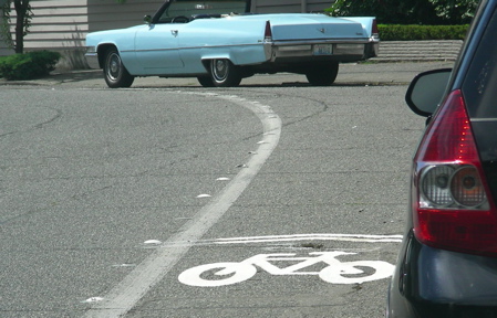
Just back from Alki Point, where we toured the upcoming sidewalk-completion project zone with SDOT workers, neighbors, and Alki Community Council leaders. Working on that story right now – many more details since the update we published last weekend — but wanted to share something that landed in the inbox while we were out, the city’s announcement of its Bicycle Master Plan Progress Report – read on for the summary (which takes note of “sharrows” like the one above, which have appeared on many stretches of West Seattle roadway in the past year or so) and link:Read More
COUNTY FURLOUGH: This is one of the 10 days this year that most of King County government is shutting down to save money. Metro service is normal, and a few essential services are open, all listed here.
I-5 WORK CLOSURES: State road crews, meantime, will be working around the clock this weekend on parts of the I-5 pavement repair project. Major lane closures start tonight and continue through early Monday morning; they’re listed here.
Just in from WSDOT, 2 open houses announced, including one at Madison Middle School on Feb. 24:Read More

When we first reported eight days ago that SDOT crews had finally put up the two red-light cameras announced 13 months earlier, the city told us that warning signs would follow, “one to two weeks before the cameras begin to operate.” So – here’s your “one- to two-week warning” – the signs you see above are on eastbound Thistle, west of 35th, and they match two signs on westbound Thistle, east of 35th. What we didn’t see this afternoon are: signs on 35th itself (where the 35th/Thistle red-light camera is supposed to be catching southbound red-light runners), nor did we see signs around the other camera, on westbound Avalon east of 35th, but we’ll be watching; let us know if you see them first (editor@westseattleblog.com)!
The governor’s new “reform” plan has at least two possible direct effects on West Seattle: She is proposing expanding hours at select Department of Licensing offices, including the one in West Seattle, which would as a result stay open till 7 pm Tuesdays through Fridays (1 1/2 hours later) and “all day” on Saturdays (currently 9-3). Also, the list of boards/committees/commissions she wants to get rid of includes the Ferry Advisory Committees; that would directly affect West Seattle, where Gary Dawson is the Fauntleroy rep on the FAC for the Washington State Ferries southern routes; that position has enabled him to get early word of major policy proposals such as the Draft Long-Range Plan and its change of direction re: Fauntleroy ferry traffic’s future (first reported here last November). If the Legislature approves elimination of those committees and others, it would take effect June 30th.
Re: the previous item about the start of pavement work on I-5 — WSDOT just announced it will NOT start tonight after all, because of the weather. Here’s the new announcement:
Grinding work scheduled to start tonight on northbound I-5 in Seattle has been postponed one day due to freezing temperatures expected overnight. The work will now begin Tuesday, Feb. 10. Long weekend closures begin Friday, Feb. 13.
This is the first week and weekend of our major I-5 pavement rehabilitation work.
Crews will close:
· Up to three lanes at night on northbound I-5 from Corson Avenue to the West Seattle Freeway Tuesday, Feb. 10 through Friday. Feb. 13.
· Lanes closures begin at 7 p.m.. Three of four lanes will be closed by 11 p.m. All lanes will reopen at 5 a.m.
· Up to three lanes at night on southbound I-5 from Stewart Street to I-90 Wednesday night, Feb. 11 through Friday morning, Feb. 13. Lane closures begin at 8 p.m. All lanes will reopen at 5 a.m.
· Up to three of four lanes on southbound I-5 between Stewart Street and just south of I-90 from Friday, Feb. 13 through Monday, Feb. 16. Lanes close at 8 p.m. on Friday and reopen at 5 a.m. Monday. Feb 16.
· The Howell Street and Union Street ramps will be closed during all southbound closures. A signed truck and vehicle detour is in place.
**UPDATE: AFTER THIS WAS PUBLISHED, WSDOT ANNOUNCED THE FIRST NIGHT’S BEEN POSTPONED … LATEST INFO HERE**

In case your commute route will be affected by the I-5 pavement work that starts tonight just south of where The Bridge meets I-5, we’re putting up the official WSDOT map before you head out for the day. There are a few more specifics here.
 Within the past few days, the last of the sub-$2 gas prices have vanished. Ahead, for the first time in 2 months, we have surveyed all West Seattle gas stations (except for Exxon at 35th/Barton, where the pumps are cordoned off – we’ll check tomorrow on whether that’s temporary or permanent), and found most prices up more than 30 cents a gallon in that timespan, even though the price of oil is lower:Read More
This past week’s California Place Park meeting reminded us we hadn’t checked lately on another  contentious issue we’d covered in Alki Community Center meetings last year — the plan to finish some sidewalk connections around Alki Point and install “traffic calming” measures as part of the project (past coverage includes these reports: 2/08, 4/08). So we called Sandra “Sam” Woods, the SDOT project manager. She says the contract for this project has been awarded – it’s part of a package of “several projects” around the city, to be handled by Construct Co. No date is set yet for construction to start – the “notice to proceed” has to be finalized – but as previously projected, it’s expected this spring/summer, Woods says. She calls the project “terrific” because of components including raised crosswalks at both ends (roughly, 65th/Alki and the start of Beach Drive) as well as work at 63rd/Alki to more clearly direct westbound traffic to turn south on 63rd rather than taking the existing “straight shot” ahead on the nonarterial section of Alki – this map marks those three spots:
We’ll get a closer look at the specific plans during a walking tour with neighborhood leaders next week; the project’s page on the city website is here.
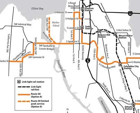
With just days left to tell Metro what you think about proposed Route 50 – which would include bus service between North Delridge and The Junction – Metro reps told the North Delridge Neighborhood Council tonight that the new route is no slam dunk. That’s just part of the news resulting from tonight’s meeting – read on for the full report:Read More

Thanks to Al for letting us know the red-light camera first announced for 35th/Thistle 13 months ago has finally arrived. That’s the wide view as crews were finishing installation work a short time ago – the actual closeup camera is toward the right side of that photo, which shows the west side of 35th, north of Thistle (map) – here’s the view we got walking right up to it:

It was January 2008 when the city announced West Seattle would get two red-light cameras in ’08 – per our original report, one watching southbound drivers at this intersection, another one watching drivers heading west on Avalon at 35th. *Added 12:06 pm* Installation on that one is under way too, on the north side of Avalon, east of 35th, by the 7-11 gas pumps:)

We asked SDOT, which installs the cameras, when they’d be working, and Marybeth Turner just replied:
We are not able to give you a date when they will be operational except that we expect it will be within weeks rather than months. When the work is completed, they will begin operating without further notice. We install the equipment, and the Police Department manages the program.
The SPD website has an info-page here which explains how the cameras work and what happens if you get a ticket issued after one of them “caught” you running the light. That page points to this one where tickets can be paid online – and you apparently even can watch video of your “violation” as it happened. ADDED 1:15 PM: SDOT also just sent word of one addition: They will install signs at the intersections “one to two weeks before the cameras begin to operate” to warn you the systems are there.
Meantime, while out on the street some call “I-35,” we also photographed the repainted lines that James tipped us to via Facebook:

As you may recall, sand and snow rubbed out the original lines, so the repainting work’s been expected for a while.

We just got e-mail as a “reminder” that the deadline is approaching for artists to apply “to develop permanent artwork in conjunction with the widening of the Spokane Street Viaduct” (basic project rendering above). The “call for artists” is dated December 18th — which happened to be THIS day — so it might not have gotten a lot of attention. The reminder explains:
The selected artist will develop a creative response to the expansive viaduct and its industrial setting. Possible locations for artwork include the underside of the viaduct’s elevated roadway, its forest of support columns, the spaces surrounding new traffic ramps, the lower Spokane Street roadway and its new sidewalk and/or other areas adjacent to the viaduct. Safety issues prevent placing artwork on the elevated roadway. The artist will determine locations for artwork in collaboration with staff from the Seattle Department of Transportation.
The city notice also says, “The budget for design (including travel costs) is $60,000. It is anticipated that $340,000 will be available for fabrication and installation, for a total project budget of $400,000.” Deadline is 11 pm February 17th; if you’re an artist, you can read a lot more about it here, including links for applying online, or see the “call for artists” page here. Before you say “What? $400,000 for art? Aren’t we having a budget crisis?” take note that the Seattle Municipal Code requires “1 percent for art” for projects like this; read the specific ordinance here. (As for the widening project itself, lower-roadway work continues as crews prepare to start on the first big component, the new 4th Ave offramp for the eastbound side; the city’s project page is here.)
Just in from SDOT:
Thursday, February 5, the Seattle Department of Transportation (SDOT) will close the right lane eastbound on the West Seattle High Level Bridge from 9 a.m. to 11:30 a.m. During the two and half hour closure, a SDOT crew will inspect the sign bridge, the overhead structure on which the directional traffic signs are mounted.
Side note if you routinely drive through South Park – SDOT also has sent word that 14th/Cloverdale (map) will be closed all weekend for pavement work, 6 pm Friday till no later than 10 pm Sunday.
 Over the weekend, we reported on a big change in Washington State Ferries‘ revised Draft Long-Range Plan — WSF has dropped its proposal to expand the Fauntleroy dock (though it’s still hoping to install an elevated passenger walkway so that car and passenger loading could be done simultaneously). We asked Gary Dawson of the Fauntleroy Community Association, who represents this area on WSF’s Ferry Advisory Committee , for reaction; he tells WSB the neighborhood still has reason to be concerned:
The current revision in the WSF LRP to no longer expand the Fauntleroy dock is good news for the residents of Fauntleroy.
However, the objection remains about the WSF decision to allow the Southworth route to remain in Fauntleroy instead of routing directly to downtown as the original draft proposed. This reversal of decision not only continues to affect Fauntleroy, it affects all of West Seattle.
Option A of the plan essentially provides no increase in service on the Vashon/Southworth/Fauntleroy route. With the proposed ferry traffic from Southworth to nearly double between the years 2020 and 2030, West Seattle, by default, must suffer all the increase in vehicles on an already congested to and over the high bridge from all areas of West Seattle.
According to recent surveys, many Southworth commuters want to go directly downtown. And they want to walk on or take a passenger only ferry. As neither option is available at this time, most are forced to commute in single occupant vehicles.
Although the Mayor’s office did not originally support expansion of the Colman Dock downtown for Southworth service, the Mayor did ask WSF to not expand at Fauntleroy and mitigate the future ferry traffic growth to West Seattle. The draft plan does leave an opening for a future route change to downtown and WSF has stated that they will continue to work with the City to arrive at an agreeable solution.
Letters of support for the redirecting of the Southworth route have been sent to the Mayor’s office from business and community groups in West Seattle. The traffic congestion in and out of West Seattle from other parts of the city are painfully apparent everyday and we can expect it to worsen with ferry traffic growth.
The Fauntleroy Ferry Advisory Committee will continue to work with WSF, the City of Seattle, West Seattle business and community groups, and any other entity necessary to help resolve this difficult problem.
Gary Dawson
As we mentioned over the weekend, both Transportation Committees in the Legislature have work sessions scheduled this week to review the revised WSF plan. The ferry system is also still collecting comments at wsfplanning@wsdot.wa.gov. In Fauntleroy, updates on the plan’s status are expected at the regular monthly FCA meeting at 7 pm February 10th and an FCA-sponsored community gathering at 7 pm February 18th.
As we reported a few hours ago, Washington State Ferries has gone public with the revised version of its Draft Long-Range Plan (see it here). It includes significant changes to the proposals for the Fauntleroy-Vashon-Southworth run – most notably, the proposal to expand the Fauntleroy dock is out. Here’s the excerpt:
WSF concurs that the draft Scenario A did not adequately address the growth and operational issues associated with the Fauntleroy-Vashon-Southworth route. The revised proposal adds a fourth, small vessel to the route, operating as a shuttle between Vashon and Southworth. This allows the other three vessels on the route to operate in direct service between Fauntleroy and Vashon and between Fauntleroy and Southworth, better utilizing the capacity on those vessels and increasing overall efficiency on the route. It also increases capacity for Southworth, which is one of the areas slated
for high growth.Based on comments heard at the Fauntleroy public hearing and comments received by the City of Seattle, the concept of expanding the Fauntleroy dock (as proposed in the draft Scenario A) is not viewed as feasible. As a result, the project has been removed from the Revised Draft Plan, and WSF will investigate all possible roadway and right-of-way options, if expanded vehicle holding is needed.
The other major proposal for the Fauntleroy dock, adding an overhead loading system for walk-on passengers, is still in the plan. Meantime, under Scenario A, here are more specifics on what size ferries would serve the broken-up “Triangle” route:
Fauntleroy-Vashon
• Two 124-car vessels, operating in direct service between Fauntleroy and Vashon
• The two 87-car Evergreen Class vessels would be retired in 2015 and 2017 and replaced on the route with 124-car vesselsFauntleroy-Southworth
• One 124-car vessel, operating in direct service between Fauntleroy and SouthworthVashon-Southworth
• A small vessel, operating between Vashon and Southworth to allow for direct service on Fauntleroy-Vashon and Fauntleroy-Southworth and increase the overall capacity on both of these routes.
The proposal says that “small vessel” would be the Hiyu, which carries 34 cars, until it’s potentially replaced “in 2027 with a used 40-50 car vessel at a cost of $12 million” (2008 dollars). Next steps: As detailed in our earlier report, both Transportation Committees in the Legislature have work sessions scheduled in the coming week to review the revised WSF plan. The ferry system says it’s also continuing to collect and forward comments at wsfplanning@wsdot.wa.gov. Meantime, the plan’s status also will be on the agenda at the regular monthly FCA meeting at 7 pm February 10th and an FCA-sponsored community gathering at 7 pm February 18th.
METRO FARES: Last warning, tomorrow’s the day they go up. Here are full details on new prices.
FERRY HEARING: Following up on the well-attended hearing in Fauntleroy a week and a half ago – next step for Washington State Ferries‘ long-range plan is a work session in the House Transportation Committee in Olympia, reviewing the plan at the start of the 3:30 pm meeting (agenda here), and a similar session at 1:30 pm Wednesday before the Senate Transportation Committee (agenda). WSF submitted its revised version of the plan today (linked here along with appendices; we are reading to see if any significant changes related to the Fauntleroy-Vashon-Southworth route). Meantime, the Kitsap County-based group Citizens Write Plan C, which is opposing both “options” in the WSF plan (A and B, ergo “C”), is organizing a rally for February 18 in Olympia; read about it here.
ADDED 11:40 PM: Looks like the draft plan DOES include major changes of relevance to our area, including removing the proposal to expand the Fauntleroy dock. Writing a separate item to publish shortly.
 New information from Dante Taylor, who’s managing the upcoming Junction parking review that may — or may not — lead to signs like the one at left. Our last update was January 13th, when Taylor appeared at the Junction Neighborhood Organization (JuNO) meeting and said the first phase would involve both informational mailers and walking tours. If you live in the area that’s being studied (Dakota to Brandon, 47th to 39th, plus the Triangle area) you should receive a mailer within the next week. As for the walking tours – Taylor would like to hear from you if you are interested in participating – it’ll involve scheduling a time to join a small group walking around the area and discussing the reality of the parking situation, good and bad, and whether any specific “tools” might be needed to improve the situation – e-mail him at JunctionParking@seattle.gov ASAP.

Three months ago, former City Councilmember Jeanette Williams  (seen at left in a city archives photo from 1973) was remembered for accomplishments including fighting to secure federal money to building the high-rise West Seattle Bridge. Now, there’s a campaign to name the bridge in her honor as the Jeanette Williams Memorial Bridge; a resolution supporting the proposal was adopted unanimously at last week’s Seattle Community Council Federation meeting and is circulating among other councils in the city as well (here’s the wording as also recently endorsed in View Ridge, according to SCCF chair Jeannie Hale). City Council approval would be required; no word yet of a timetable for a formal proposal coming before the council, but we asked Councilmember Tom Rasmussen – who got his political start working with Ms. Williams – and he told WSB he’s all for it. We’ll keep you posted. (Maybe it’ll happen in time for the bridge’s 25th anniversary this summer?)
Just in from SDOT – the full news release is ahead; note that the three pilot bike-parking areas are all outside West Seattle, but the department offers a way for you to propose one:Read More
SOUND TRANSIT: Route 560, which includes West Seattle, is one of the routes with changes to come, in part because of ST light rail, so a public-comment meeting has just been set for Feb. 25, 5-7 pm, Senior Center of West Seattle in The Junction. Read more about it here.
METRO RATE INCREASE: This Sunday is the day that Metro Transit fares go up a quarter. See the new fare schedule in its entirety here.
Washington State Ferries says it’s making some changes in a month regarding how fares are collected, including: No more checks. Read on for details of the WSF announcement:Read More
| Comments Off on Reminder: What’s different (and not) tomorrow, Presidents Day