West Seattle, Washington
20 Saturday
 (WSB photo, April)
Last spring, SDOT installed a protected two-way bike lane along part of West Marginal Way SW, more than two years after proposing it and eventually agreeing to delay it until the West Seattle Bridge reopened. This week, it’s released data on how the lane addition is – or isn’t – affecting traffic, and what kind of rider usage it’s drawn. Overall, SDOT says, the change has added half a second to the average travel time. It’s also added people biking, walking, and rolling on the stretch, with stats including:

SDOT was hoping to bring down vehicle speeds, with radar feedback signs and a speed limit reduction to 30 mph. Their slide deck says that in fall 2022 vehicles were averaging 37 mph at West Marginal/SW Alaska, and are now averaging just under 38 mph, but at SW Dakota, they’re down to 36.4 mph from 40.2 a year earlier. The slide deck has many other data views, including “interaction” analysis at business driveways, and there’s even more in this 26-page report. Here’s what SDOT says is yet to come on the stretch:

This year’s Seattle Public Safety Survey is open for just a few more days. Researchers from Seattle University hope to find out your primary safety concerns and convey them to SPD.

Here’s the direct link to the survey, with a-dropdown on that page offering a choice of 11 languages. The survey is open through Thursday, last day of the month.
P.S. Here are the results of last year’s citywide survey.
Two reader reports this afternoon:
IS THIS YOUR TENNIS BAG? Sent by Jonathan – could be lost, could be stolen-and-dumped:
Discovered this apparently discarded tennis backpack at 3 pm Sunday on the sideway just west of the intersection of 42nd Ave. SW and Findlay St., just off the alleyway behind C&P Coffee.
All the zipper pockets were opened. I peeked inside for ID but found none. Maybe someone can be reunited with their tennis gear, which included two racquets, can of tennis balls and shoes.
If you’re missing this, email us and we’ll connect you. (UPDATE: Owner found, reunion in progress. The bag fell off her motorcycle.)
ILLEGAL DUMPING: From Ian:
Someone dumped a large amount of junk in the middle of the road at the intersection of 37th and 102nd SW around 7:30am. Looks like they stole a random pallet worth of literal trash, found nothing valuable, and just randomly jettisoned it. Neighbor said he saw a white truck driving away.
If you see something dumped in the public right of way, you can report it to SDOT – 206-684-ROAD or, after hours, 206-386-1218. If urgent and causing a major safety hazard, you also can call 911.
If you haven’t already answered this year’s Seattle Public Safety Survey, researchers at Seattle University hope you’ll do it sometime before month’s end:
Every year, Seattle U researchers conduct this community survey “to try and assess the main concerns of Seattle residents and convey those concerns to the police department. We want to make sure we hear from as much of the West Seattle residents as possible.” Here’s the direct link – use the dropdown on that page to choose which of 11 languages you want to use. If you’re interested – here are the results of last year’s citywide survey.
Received from Joel:
Just wanted to let West Seattleites know that a disgruntled neighbor threw garbage, including glass bottles, into the Delridge skatepark this evening. He was upset about the refuse being left behind on a daily basis.
I cleaned up what glass I could, and notified the police, but I’m sure there are small shards left that could hurt someone if they were to fall.
We suggested also calling the Seattle Parks after-hours maintenance number (206-684-7250).
Just received from SPD crime-prevention coordinator Sarah Lawson:
We will be holding a Personal Safety Class on November 9th from 6 PM to 8 PM virtually. We will discuss things such as awareness, trusting our instincts, making a safety plan, how to stay safe in different situations, how to call 911, etc. The class is suitable for anyone 14 years old and older who would like to learn some basic tips and tricks to live, learn, and work safety in Seattle. Here is the link to register.
While the webpage for the class says it’s “full,” Sarah says it’s NOT, so sign up for the waitlist and you’ll be registered from there.
She also has provided four flyers with personal-safety information, in light of recent robberies targeting all ages:
Purse Snatching
Phone Snatching
Safety for Youth, part 1
Safety for Youth, part 2
 (WSB photo)
Sitting outside the Southwest Precinct, ready to collect your donations for the West Seattle Food Bank – and/or unwanted/expired prescription drugs for safe disposal – are, from left, SPD Officer Matthew Roberson, SPD Crime Prevention Coordinator Sarah Lawson, and Yuri Bolivar and Donna Kelly with Drug-Free Youth. Drug Take-Back Day happens twice a year, but adding a donation drive for food and warm clothing, to benefit WSFB and its Clothesline clothing bank, is new. They’ll be there until 2 pm, at 2300 SW Webster (the public lot entrance is just east of The Home Depot’s south entrance). The wish list of requested donations is here.

That’s the long-vacant-and-vandalized house at the far north end of Delridge Way, officially known as 3804 23rd Avenue SW, in our photo from late Thursday afternoon. Earlier this month, thanks to a reader tip, we reported on an “emergency order” by the city, as part of a longrunning investigation of violations, telling the owner to “close” the house immediately, among other things. It’s since been boarded up and cleaned up, but not because the owner took action.

A reader sent us that photo on Tuesday. An accompanying photo showed a junk-hauling truck with a company name we recognized as a city contractor we’ve seen before at encampment cleanups. We subsequently asked the Department of Construction and Inspections about the property’s status; here’s the reply from spokesperson Bryan Stevens:
An Emergency Order (EO) was issued on October 10 under case 1056926-VI for a vacant building open to entry, outdoor debris, and vegetation. The EO required compliance from the property owner by October 16. The required maintenance was not completed by the property owner, so SDCI commissioned a contractor to secure the lower openings and complete the cleanup to close out the EO condition. The cost will be billed to the property owner along with related inspection fees. The building will continue to be monitored via monthly inspections through our Vacant Building Monitoring Program. However, the public should continue to file a complaint if they notice the building open to entry or additional debris. Complaints can be filed online or via phone at 206-615-0808.
We asked about the amount that’ll be “billed to the property owner”; Stevens said he wouldn’t be able to get that for us until next week. The site has had various development plans under various owners over the year; most recently, there was a proposal to renovate the house, but that plan doesn’t appear to have advanced beyond an early stage.
 (City of Seattle photos)
12:27 PM: You’ve likely heard a lot lately about the city’s plan for a pilot “dual dispatch” program as part of the new CARE department, sending non-police responders to certain types of emergency calls. Its launch was formally announced by the city today, describing this as “a foundational program for Seattle’s newest public safety department: the Community Assisted Response and Engagement (CARE) department,” the third public-safety department after Seattle Police and Seattle Fire. The new team’s apparel and vehicles were shown off too.

The city says the new CARE response team “features behavioral health specialists, who all have prior field experience along with a bachelor’s or master’s degree related to the field,” responding to certain person-in-crisis situations. Initially, they’ll be focused downtown (including the C-ID and SODO), so you’re not likely to see them in West Seattle any time soon. From the city announcement, here’s how it works, and where it will initially be focused:
The dual dispatch pilot pairs CARE responders with SPD officers, with both units dispatched simultaneously by the 911 Center, which is also housed in the CARE Department. After arriving at the scene and ensuring it is safe, SPD officers can respond to other calls while the CARE responders provide services. This initial dual dispatch pilot model will inform future development of diversified response and is designed to accommodate rapid iteration and continuous improvement. This program allows the City to deploy new teams specialized to help people in crisis, safely gather critical data to grow the program responsibly, and make an immediate impact freeing up critical and sometimes scarce police and fire resources.
The pilot is initially focused on Downtown, including the Chinatown-International District and SODO, operating from 11 am to 11 pm, a schedule that matches where and when the most frequent calls related to mental health crisis occur. …
CARE responders are dispatched by calling 9-1-1 like the City’s other emergency services. Trained call takers in the City’s 911 Center will decide which incidents are appropriate for this response. There is no number to call to directly request a CARE response. Call takers and dispatchers in the 911 Center have been trained on new protocols for sending out the new CARE responders, and SPD command staff have met with officers across precincts to answer questions about this new approach.
Calls eligible for a CARE response include low-acuity welfare checks, calls that don’t need enforcement, and others that are non-violent, non-emergent, and non-medical. In the City’s dispatch system these calls are coded as “person down” or “wellness/welfare check,” there have been 2,686 person down calls and 5,533 wellness/welfare check calls so far in 2023.
Mayor Harrell has proposed a $26.5 million budget for the CARE department next year, 30 percent more than this year, but that’s not just for the “dual-dispatch” program.
ADDED 2:04 PM: Among the community members from around the city who were invited to today’s announcement was Morgan Community Association president Deb Barker. She sent this photo of acting CARE director Amy Smith speaking during the event at City Hall:

Here’s the Seattle Channel video of the announcement event.
By Tracy Record
West Seattle Blog editor
If you have something to say about the draft Seattle Transportation Plan, you have one more week to say it – October 23 is the deadline.
One West Seattle man is not only commenting – he’s proposing a neighborhood transportation transformation as his feedback, and he’s inviting you to travel along.
Maybe you’ve seen the flyers Jack Conness has posted in Highland Park and South Delridge, pointing you to his Highland Park Public Transformation Plan website:

After a reader saw one of Jack’s flyers and told us about it, we contacted Jack to find out more, and sat down with him for an early-morning chat at Fresh Flours Bakery in South Delridge. Jack is a relatively new arrival – two years ago – to south Highland Park, a former Californian who is originally from “90 miles west of Chicago.”
While he landed here with the thought that it might be a stepping stone to another area of Seattle, he says he’s “fallen in love with this neighborhood” and that’s why he is proposing a plan to make it safer. “I thought I could put something out there that might sway decisionmakers (and) instead of just submitting a comment myself, I could submit a comment with lots of people.” He also admits he’s a “bit weird and wonky” at heart.

His experience of getting around started with arriving here as a UW graduate student – during the West Seattle Bridge closure – and having to get to UW. That put him in the public transportation system, taking the bus to light rail to get to school. (He’s enamored with how Seattle is expanding its light-rail system, even knowing that’s more because the region is trying to catch up, than leaping ahead.)
He works in climate-change policy, so he’s interested in that aspect of transportation too, aware that to get people onto buses and rail they have to be more safe and available.
But right outside our doors, being able to walk and bike safely in neighborhoods is the first step (literally). So he’s outlined some ideas.

He lives near 14th and Roxbury, and crosses the latter “all the time” to get to the “incredible food and nightlife options” in White Center. “It’s a nightmare” and was even more so when the bridge closure made Roxbury another major detour route, leaving drivers “sitting on the crosswalk in their vehicles.” Another street that factors into his plan, SW Henderson, for which he proposes reconfiguration:


“It splits north and south Highland Park and feels like a freeway – built for speed.” No place to truly safely cross between 9th and 16th, he says, but families in south Highland Park have to cross it to get to Highland Park Elementary on SW Trenton. No kids in his family yet, but he and his wife cross with their dog. “It’s dangerous. Our neighbors have kids – not a fun trek to make. So how do we make it safer and friendlier” for everyone to cross? He also has ideas for Thistle, 16th, Roxbury, and 10th, with some raised crosswalks in the mix too.
Getting to Westcrest Park is another challenge. “It’s a great park but there’s no safe way to get there unless you’re driving.” And to those who are skeptical because they’re not seeing many people walking or biking now, Jack offers a line from a movie about professional baseball (in which he worked): “If you build it, they will come.” And that means more chances to interact with your neighbors.
He started getting the word out via posters because he figured people already walking and biking would be those most interested in his ideas. They had been barely up a week by the time we talked on Friday, and he’d already received almost 50 signatures. The first one, he recalled, “was an incredible feeling – somebody else feels the way I do.” He’s also already met with some interested residents who are “trying to find ways to get involved … I didn’t expect this outcome so quickly, I thought I was the only weird person out there.”
Jack has also talked with people who have long been involved and heard about “the battles they’ve had to fight.” He hopes he can add new energy to the fight. He is also encouraged by the new leadership in SDOT – this is the first year for director Greg Spotts – “I’ve been following what they’re up to … (things) can’t change overnight but I’m very much excited and motivated, so that’s part of why I wanted to get involved.” He’s requested one of the neighborhood walking tours Spotts has promised to attend.
But right now, he wants to find out who else is interested in signing on to his plan before he sends it to the city for consideration before the draft Seattle Transportation Plan becomes the official Seattle Transportation Plan. That won’t be the end of his efforts, though, but just the beginning. “The intent is, low-cost, low-barrier moves that can be made. This is step one of many more.”
We ask, if just one part of your plan can become reality for starters, what would it be? SW Henderson, Jack replies, seeing it as a “simple fix” with stop signs and bicycle infrastructure.
His plan also suggests a bike path araund Highland Park Elementary and the park next to it – “imagine if you could safely send your kid out on that bike path … It’s an incredible community that’s continuing to grow (and) invite more people in.”

And the people, he believes, is who should take precedence on the streets – it’s not good enough, in his view, to have “greenways” which are supposed to be shared streets where “you have to trust drivers” so the signage confers “a false sense of security.” Other halfway measures aren’t enough, either: “Crosswalks with a flag are a policy failure.”
You can see Jack’s full proposal here. Here’s where you can sign on, if you support it. (Or if you want to submit your own comment on the draft Seattle Transportation Plan, you can go here.) Wherever his ideas go, he’s optimistic: “The future is bright.”

Thanks to the texter who tipped us about this today. The owners of West Seattle’s most-visible vacant house – 3804 23rd SW, along the Delridge onramp to the West Seattle Bridge – are under an “emergency order” to seal it up by tomorrow morning. The texter noted this order tacked up at the property:

It orders the building to be “closed” by 8 am tomorrow. We went by late today and didn’t see any sign of work to do that. We’ve mentioned this house many times over the years, most recently half a year ago, when we discovered a plan to remodel it. That plan does not appear to have advanced past pre-application stage so far. Meantime, the violation that has led to the “emergency order” to seal the house by tomorrow is related to at least four prior violations of the city’s Vacant Building Standards. Here’s the full notice; it says that if the owner doesn’t comply by the deadline, they can be fined up to $1,000 a day, and: “the [Department of Construction and Inspections] Director may take corrective action and recover the costs of that action (and) the City may file a lawsuit against you to collect the penalties and costs.” We’ll watch to see if anything comes of it; the house has been a problem spot for many years, even called out on a community-organized tour of problem properties in 2009, with city councilmembers and department heads in attendance.
If you’re looking for something to do online, besides read, here are two city surveys open right now, both offering a chance at incentives:
SEATTLE STREET SMARTS: SDOT is currently advertising this short survey on WSB. It’s mostly a test of when and where to stop for people crossing the street. Go here to answer it.
WASTE PREVENTION: Seattle Public Utilities is trying to figure out what would get us all to a future where nothing – or at least, very little – is thrown away. This survey asks you what you’re doing now and what would be needed to get you to do more. Go here to find the link (and get more context).
Jill just sent this:
After a near-miss in which my child was almost struck by a reckless driver, we wanted to both remind our community to drive safely and ask if any witnesses have any information about the incident.
Just before 12:30 pm this afternoon, my husband was walking with our son on Charlestown, crossing California westbound, on the north side of the crosswalk, on a green light with a walk sign. When the light turned green, the car that had been stopped on Charlestown facing east entered the intersection and then turned left (northbound) onto California and accelerated through the crosswalk. My husband says that they had looked both ways and were alert prior to crossing, but that there was no way that he could have anticipated the acceleration of the car. He stopped and yelled loudly as the car came toward them, and our child reacted by running out of the way just in time–otherwise, our child would have been struck, with who knows what awful outcome. My husband believes the car was a small black Prius, and he is certain that he saw the driver on his phone–but didn’t get a license plate number before the car sped off.
We want to say thank you to the driver of the car behind the reckless driver, who got out to make sure my husband and child were okay, as well as to the passersby on the sidewalks who also expressed concern and care in that frightening moment.
We contacted the non-emergency police line to report this case of reckless driving (which we thought was the proper course of action, since the situation had passed, and there were no injuries.) However, because we didn’t have a license plate number, or other identifying information, they wouldn’t take a report. If anyone who witnessed the situation has information, we would appreciate if they would be willing to share.
(For what it’s worth, we were advised that if something like this were to happen again, we should call 911 immediately, so that officers in the area could be on the lookout for a car matching the description.)

Thanks to Greg for the tip. The three sets of speed bumps announced earlier this year for SW Genesee, near Genesee Hill Elementary, were installed today, the day before the scheduled start of Seattle Public Schools‘ 2023-2024 classes. Other West Seattle school areas with new traffic-safety installations over the summer include Lafayette Elementary, Pathfinder K-8, and the Denny/Sealth campus.
We’ve heard from three readers about a hazardous “pothole” on the West Seattle Bridge, so we’re sharing the heads-up, in advance of checking with SDOT tomorrow about repair plans. Mike was first to describe it:
Heads up for drivers headed Eastbound on the West Seattle Bridge. There’s missing pavement in the right lane at the curve high above Avalon. It appears that this is occurring in the newly grooved pavement as you head to the Bridge proper. For now you can drive around it but since it’s on the curve the hazard comes up quickly.
There are multiple ways to report problems like this on city streets and structures – SDOT’s hotline is 206-684-ROAD; an online reporting form is linked here, as is the city’s map of what’s been reported and/or fixed recently – which shows work is “pending” on this one.

Thanks to the texter who sent the photo and report of the recently installed all-way stop, and painted crosswalks, at 44th/Lander, on the south side of Lafayette Elementary. This plan was mentioned by commenter Tony following our report last month about other school zones getting new all-way stops.

6:06 PM: Three and a half weeks after we reported
speed humps/cushions were on the way to SW Thistle and other streets around the Sealth/Denny campus, installation has begun. We noticed the fresh asphalt protrusions while headed eastbound on Thistle a bit earlier. It appeared the eastbound installation was further along than the westbound side.
8:11 PM: Going back the other way, we were able to see that the sets on Thistle are complete. We weren’t able to check 27th, 25th, or Kenyon.
 (WSB photo, June)
In hopes that fewer Hyundais and Kias will wind up like that one – stolen and pushed down a slope at Westcrest Park – SPD is giving away more steering-wheel locks. After two giveaways in April, two more dates have just been announced for late August and early September. Sent today by Southwest Precinct Crime Prevention Coordinator Jennifer Satterwhite:
In response to a rise in vehicle thefts involving certain Kia and Hyundai models, SPD’s Crime Prevention Coordinators will be giving away steering wheel locks at each of its five precincts this summer.
Dates & Times:
Tuesday August 29th : 2:30 pm – 6:30 pm
Saturday September 2nd : 9:30 am – 11:30 amLocations:
East Precinct – 1519 12th Avenue
West Precinct – 810 Virginia Street
North Precinct – 10049 College Way N
South Precinct – 3001 S Myrtle Street
Southwest Precinct – 2300 SW Webster StreetThe devices are available at no charge to people who live or work in the City of Seattle, with a focus on those who own or lease a Kia or Hyundai vehicle. Due to limited availability, locks cannot be set aside or held. Only one lock allowed per person. Please go to the pickup event scheduled for the precinct where you live or work.

6:45 PM: Among the hundreds of West Seattle neighborhoods having Night Out block/building parties tonight is this one in Seaview, where Elyse and her neighbors are gathering for the first time.

Even something fun for the kids:

We’re making several stops tonight and also are welcoming your block-party photos (westseattleblog@gmail.com). If you’re not at a Night Out party tonight, be mindful of the many makeshift STREET CLOSED signs on non-arterials through 9 pm or so. Updates to come!
6:59 PM: One of the benefits of registering yuur Night Out party, though it’s not mandatory, is that you can ask for public-safety personnel to visit.

Also in Seaview, the party on Melody‘s block (you might know her as chair of the Southwest Precinct Crime Prevention Council) got a visit from the SPD Mounted Patrol, which is headquartered in West Seattle, at Westcrest Park. At left below is Chance, at right, Buzz:

Plus Melody and neighbors:

7:20 PM: In Gatewood, Jennifer invited us to stop by her block party –

It’s one of at least several tonight with live music:

That’s the voice of the Mariners, Tom Hutyler, performing. (Video added:)
7:40 PM: In Sunrise Heights, Lizzy and Vinnie are hosting a wood-fired-pizza block party:

They made the dough and sauce – neighbors brought the toppings:

7:54 PM: Another party with music is in east Gatewood – Reference Only is playing – video (added):
This party also has an inflatable Irish pub – at right in the background of our group photo:

9:14 PM: We’re adding more after taking a break this past hour for election-night coverage. Next photo is from our first stop of the night – every year when registration opens for Night Out, JoDean invites us to her Arbor Heights block party:

Night Out is for all ages. Jon sent the next pic from his block party west of The Junction – with him is 100-year-old neighbor Marie, who he reports is “still going strong”:

9:58 PM: We didn’t get to join in our Upper Fauntleroy neighborhood’s party since we were out photographing others, but we did take this pic of our neighbors upon return:

Not far away, here’s the Northrop Block Watch party, in the neighborhood at the top of the famously long SW Thistle stairs:

Melinda sent this photo from her Youngstown-area block party:

She reports: “We finally took a photo of our Night Out BBQ/Potluck — after 40 or so years!! “A good time was had by all” as was reported in the weekly Redfield Press of Redfield, South Dakota when I was a kid referring to Altar Society, 4-H club, etc meetings.” … Next pic is from Allison in Arbor Heights:

Pete’s party in Pigeon Point drew Southwest Precinct visitors:

And a texter shared this party photo from Fauntlee Hills:

Next year will be the 40th anniversary of the first nationwide Night Out.
ADDED WEDNESDAY: Two more photos – Carole says she and her neighbors had a great time at Cottage Grove Park:

And Barb appreciated the SPD officers who visited her neighborhood’s party:

Thanks again to everyone who shared photos or told us where they were gathering so we could stop by!
Almost two months after the City Council rejected a proposal to match city law with the new state law about public drug use, Mayor Bruce Harrell is out with his plan. It’s the result of the committee he formed after that vote (the members are listed here). At the heart of it is city legislation that the mayor’s announcement says would:
-Codify state law and make public consumption of illegal drugs a gross misdemeanor in the city of Seattle.
-For the first time in the City’s history, designate diversion and treatment as the preferred approach to addressing substance use issues – connecting people with care and responding to a public health crisis with evidence-based health solutions.
-Define a new threat of harm standard – differentiating between drug use that threatens others versus the individual alone, recognizing the real and perceived danger of consumption of illegal drugs in public places, and aiming to support safe and welcoming neighborhoods by reducing public use.
The aim is not to jail drug users, according to Harrell, who is quoted in the announcement as saying, “Success will not – and cannot – be measured on how many people cycle through jail; instead, our focus is on improving connections to lifesaving treatment and expanding program options to better meet the needs of those with substance use issues.” So what would the mayor’s proposal mean for law enforcement? The announcement says he’ll issue an Executive Order next week “providing guidance to Seattle Police Department officers on how the law should be applied, further detailing threat of harm standards, and defining tools to collect and analyze data to measure success.”
 Hundreds of West Seattle streets will be closed for block parties on Tuesday night (August 1st), this year’s Night Out. It’s a nationwide night for community-building, with a focus on safety and preparedness, and a great chance to check in with your neighbors if you don’t get to chat much over the course of the year. You can see some of the areas where parties are planned by looking at the map on SPD’s Night Out page. If you’re not participating in a Night Out party, be careful when you’re traveling between 5 and 9 pm Tuesday night, as those are the hours for most street closures. P.S. If you’re having a party and wouldn’t mind us stopping by for a photo, email us – westseattleblog@gmail.com – thank you!
Two City Council notes:
PRICE TAG FOR RACING TICKET: After last week’s much-reported full-council vote authorizing speed-enforcement cameras in designated “racing zones,” including Alki and Harbor Avenues and West Marginal Way, enforcement cameras will be discussed by the Transportation and Public Utilities Committee this Tuesday. The major topic is a discussion of potentially doubling the number of school-zone speed-enforcement cameras around the city, though new locations aren’t mentioned. In the slide deck prepared for the discussion, SDOT says school-zone cameras have improved safety, with stats on page 6 saying average speeds in the zones have declined slightly, and collisions have declined dramatically. Then the committee moves on to consider legislation allowing even more uses for enforcement cameras. From the staff summary:
This legislation amends SMC provisions regarding use of automated traffic safety cameras to implement several new provisions authorized by the state legislature in 2022 with passage of the Move Ahead Washington transportation package. These provisions allow for 24/7 speed limit enforcement in school walk areas, park and hospital zones, and on additional streets – up to 1 camera per 10,000 population – that have either 1) been identified as a priority location in a local road safety plan that a city has submitted to WSDOT and where other speed reduction measures are not feasible or have not been sufficiently effective at reducing travel speed; 2) have a significantly higher rate of collisions than the city average in a period of at least 3 years and other speed reduction measures are not feasible or have not been sufficiently effective at reducing travel speed; or 3) is in an area designated by ordinance as a street racing zone.
The legislation also sets the fees/fines for the various types of enforcement – $75 for block-the-box or restricted-lane violations, and $139 for speed enforcement including “racing zone” cameras (same as the current red-light-camera fee). This does not affect or change the amount charged for school-zone speed violations, currently $237. The committee’s meeting is at 9;30 am Tuesday (August 1st) and the agenda explains how to watch/comment.
ORGANIZED RETAIL CRIME: That’s the umbrella term for organized shoplifting and fencing, discussed in the council’s Public Safety and Human Services Committee this past Tuesday. The occasion: A City Auditor report, requested by Councilmembers Lisa Herbold and Andrew Lewis, reviewing the state of the problem and how the city handles it. Here’s the report; here’s the meeting video:
Of local interest, note this table of Seattle locations that generate the most calls to police for shoplifting:

Westwood Village is number two, and Westwood Target (technically not part of the shopping center) is number five. The problem overall is estimated at $2.7 billion statewide in the past year. Here’s what the City Auditor’s Office says could be done to try to reduce it:
1. Support City participation in collaborative efforts among agencies, including collaboration with the new Organized Retail Crime Unit in the Washington State Attorney General’s Office.
2. Leverage federal and state crime analysis resources.
3. Use in-custody interviews of “boosters” — people who steal on behalf of fencing operations — to gather information on fencing operations.
4. Explore new uses of technology to address ORC.
5. Use place-based approaches to disrupt unregulated street markets.
6. Follow the King County Prosecuting Attorney’s Office “prosecution checklist” for ORC cases.
7. Consider City support of legislation that addresses ORC.
Tuesday’s meeting was just a discussion of the report and the problem; any action, on those seven points and/or others, would come later, and aren’t necessarily in the purview of the council. Participants in the discussion also included SPD, the City Attorney’s Office, and King County Prosecuting Attorney’s Office.
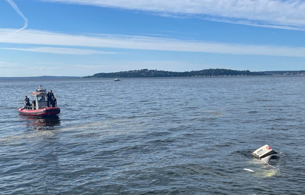 (July 16th reader photo sent by Reiner)
By Tracy Record
West Seattle Blog editor
One week ago, heroic passersby pulled a woman out of her submerged car off Alki Avenue, after a speeding driver hit it so hard that it was shoved off the road, over an embankment, and into Elliott Bay.
The crash was the major topic of this past week’s monthly Alki Community Council meeting. About 15 people attended in person at Alki UCC, with others participating online, including Southwest Precinct second-in-command Lt. Dorothy Kim.


| 37 COMMENTS