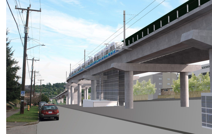
 (Sound Transit rendering, possible routing at Genesee looking east toward Avalon)
By Tracy Record
West Seattle Blog editor
If you haven’t yet decided what you want/need to say during the last major comment period before Sound Transit locks in West Seattle light-rail routing and station locations, a community workshop Thursday might help you formulate your feedback on the Draft Environmental Impact Statement. (More about that later.)
Some neighborhoods in light rail’s potential path have been studying the proposal independently and extensively almost every step of the way. Among them, Avalon-area residents, some of whom might be forced out of their homes depending on where the train goes to get between the Duwamish River and the West Seattle Junction. They’ve had several meetings with ST, including one last Thursday night devoted solely to Q&A. Hours before that, they accompanied ST reps on a walk through the neighborhood, from the westernmost potential Avalon station location eastward along potential routing paths. We covered both events and have chronicled some of their other discussions, going back almost two years to this one, shortly after they learned the ST Board had decided to study a route through their neighborhood.

Thursday’s walking tour was intended to be a firsthand look at where the station might go, and how the trains would get there. Neighbors and ST reps, plus a rep for King County Councilmember and ST Board member Joe McDermott, gathered first by the Avalon Starbucks and Taco Time. ST’s reps included Jason Hampton, currently the lead for the West Seattle extension. This had been long enough in the works that ST brought the hard-copy equivalent of a slide presentation, customized for this tour.

After introductions, it was off to the first stop on the north side of Pecos Pit (WSB sponsor) at 35th/Genesee, which would be at the west end of an elevated Avalon station, with a 55′-high platform – or just northeast of a tunneled station going 90′ down.

What Avalon gets depends on what the board chooses for the Delridge and Junction stations, primarily the latter. And in turn, getting to a tunneled Avalon station would mean a tunnel starting at the SW Genesee/Avalon hilltop, around where the Golden Tee Apartments are now.
“How long would it take to get down” to the 90-foot-deep tunneled station? wondered one participant. That’s not in the DEIS, apparently. Neighbors also wondered about parking, since none of the stations will have it. Hampton said an RPZ would be a possibility to ensure the street spaces didn’t all vanish to “hide-and ride” drivers. They also discussed where Transit-Oriented Development housing might go once the line is open – that could replace the Starbucks and Taco Time, for example.
Walking to 32nd and Genesee, the heart of the residential neighborhood, neighbors had many questions about which houses would stay and which would have to go. They’re nowhere near a final design, Hampton reminded everyone. But as they talked more about the possibilities that were studied, one thing was clear – stations have a sizable footprint. Commenting on the DEIS, you will want to be very specific about which station option you would want to see and the Junction and Delridge options that go with it.
The neighbors weren’t just trying to imagine the stations and guideways; as Kim Schwarzkopf, who coordinated the tour, described it, “we’re trying to envision what life will be like during construction.” Also comment on construction concerns, Hampton advised the neighbors when that came up in the conversation. The neighbors tried to pull out as many details as they could – how fast would the trains be going? Hampton said they could travel up to 55 mph on elevated tracks but on the West Seattle extension, that’s only likely crossing the Duwamish (a rail-only bridge whose route hasn’t been settled yet either).
The group continued on, to 32nd/Andover – noting that’s a popular bike route, connecting to the recently strengthened bridge across the west end of the West Seattle Bridge – and then Avalon/Yancy/Andover, where an elevated track would be 80 feet – eight stories high.

There, the tour wrapped. Less than eight hours later, the Q&A session began online. This was entirely discussion, no presentation – the Avalon neighbors have been through many of those. Questions started with displacement-related issues. For some properties, they might be working on mitigation rather than acquisition, ST said. Same with properties potentially affected with construction activity – too doon to narrow down exact effects, so ST will “keep talking” with the community as more is known.
One person asked about what led up to the choice of routing alternatives that were studied for the DEIS – they would like to see a tunnel that’s not on the list of possibilities, and they wondered why. Hampton noted that Appendix M of the DEIS discusses the process during which the alternatives were developed. Even at this stage of the process, ST reps said, you can suggest “refinements,” but people should realize that studying new options might add to the schedule. The higher costs that led to the recent “realighment” was also pointed out. “Doesn’t mean you can’t advocate” for something different, but keep it in mind. Something similar was looked at in the early going, but it was tossed out for several reasons, including that it would only result in two stations, and voters approved three. (This is briefly summarized on page 15 of Appendix M.) Also noted: Not only is tunneling expensive, so is undergrounding stations.
At this point, the suggestion of dropping the Avalon station resurfacing – maybe that would enable more tunneling? Discussion also turned to station and routing pairings – it’s not all mix-and-matchable.
Question: Where in the DEIS can information about construction staging be found? Answer: Appendix J. Page 48 was shown as one example, showing stormwater facilities, power-related facilities, “signal bungalows,’ and other things beyond just the guideways. They were asked to show something with the Avalon Station; page 73 was brought up. Looking at those drawings, they again asked for clarity on what properties would be acquired – the black dash line, for example, is the boundary of the staging area, and if a property is potentially affected, you’ll find that in Appendix L.
Then the question came up yet again: How easy would it be (or not) to let go of the Avalon station in the plan? ST has clearly in the past skipped a station or deferred/delayed it for various reasons, one attendee observed, and added that people have long discussed ditching or at least deferring it. It’s pointed out that Metro has been planning to serve Delridge and Junction stations with transit, not Avalon. ST replied that Metro will be serving the Avalon station, “but not with many routes.” Also, ST is definitely in the process of figuring out how to address the “affordability gap.” ST will propose some ideas and expects some from the public.
Asked to explain a potential .06 acres of golf-course impacts, ST explained that it’s space that would be permanently removed from the park, not part of the construction staging area. What could be done under the guideway would depend on various factors. Aligning on the north side of Genesee would still have some effects on homes. They might need to use “straddle bents” – columns on both sides of the road – rather than just concrete columns down the middle.
What about businesses like Nucor, or the potential displacement of Transitional Resources ….what kind of outreach are they getting? ST’s Leda Chahim acknowledged some businesses/facilities would be particularly difficult to relocate. They’re just trying to explain “how to engage in the process now” and to “highlight the opportunity of sharing with our board.” She said ST is trying to learn more about the unique organizations and institutions in the area.
Bottom line, observed a neighbor, you’re bringing a train through a developed area.
Looking beyond the planned-for-2032 West Seattle light-rail launch, what is the thought about ST4? one attendee asked. Would it go to White Center, and what beyond that? Answer: The ST3 measure called for long-range studies but they haven’t been done yet. Following up on that, an attendee asked if what’s done in The Junction will determine how it would proceed south – if it ends in a tunnel, does that mean tunneling would follow to get to the south? Answer: Potentially.
It was brought up at that point that Metro had said that the long range vision for the H Line might be as a cross-West Seattle route. Ella Williams from Joe McDermott’s office advised reviewing Metro’s long-range plan.
Last but not least, ST reiterated that all the comments received on the DEIS will have to be addressed in the final EIS, which will be followed by board members deciding what will be built, “late 2023.” While a “preferred alternative” will be “confirmed or modified” before the final EIS, it’s not the last word. ST characterized what happens from here is for each step in the process to hone in a little more.
READY TO CRAFT YOUR COMMENT? Even if the light-rail line isn’t going near or through your neighborhood, your input matters – what routing, whether tunneled or elevated, how transit connects to the station you’re likely to use – whatever you want to say, figuring out the most effective way to say it is what the West Seattle Transportation Coalition‘s workshop Thursday night (April 7th) is all about. Between 6 and 9 pm, you can either go to American Legion Post 160 (3618 SW Alaska) in person, or watch/participate online – our calendar listing has the link. April 28th is the deadline for commenting – your options are here.
| 56 COMMENTS