‘A hard conversation to have’: Sound Transit faces residents who might be forced from their homes by West Seattle light rail

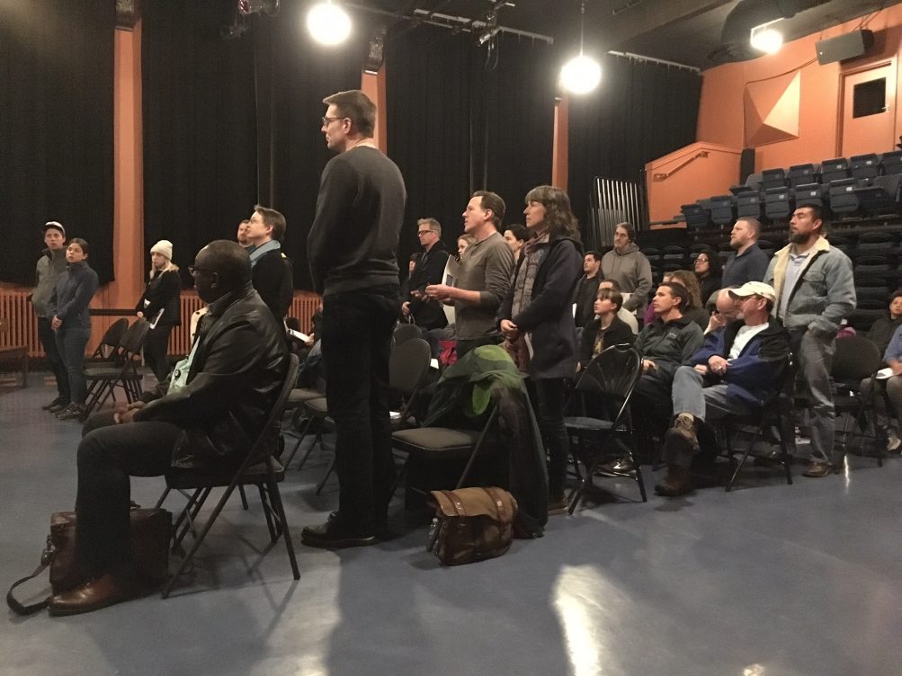
(WSB photo: Youngstown-area residents gathered to hear about light rail that might force them to move)

By Tracy Record
West Seattle Blog editor

Light rail does not just appear one day in a neighborhood where it didn’t exist the day before.

Years of construction follow years of planning.

Some of that construction is preceded by demolition – tearing down homes and businesses that, to put it bluntly, are declared to be in the way.

That will happen to some in West Seattle. Just where, and how many homes and businesses, won’t be settled until the route and station locations for the due-to-open-in-2030 line are finalized. But some people for whom it’s a possibility are already grappling with it. This past Wednesday night, dozens of them gathered at Youngstown Cultural Arts Center with pointed questions for Sound Transit – questions that in many cases, ST reps said, it’s too soon to answer. Most of the people in attendance were from nearby streets where construction of the Delridge station might push them out, depending on what location is chosen.

The briefing/Q&A event was organized by a neighbor, Dennis Noland, who opened by saying, “It was devastating news to me” to find out that Sound Transit’s West Seattle light-rail plan might cost him and some of his neighbors their homes. Noland took it on himself to personally talk with neighbors after that revelation last fall.

The next step in that was organizing the meeting, intended for neighbors – “specifically a two-block area” bounded by, as he explained it:

SW Genesee on the south
SW Dakota on the north
West side of Delridge Way SW on the east
26th SW transecting 25th SW on the west

We recorded the 2-hour-plus event, but our video is mostly just of use for the audio as the projected slides could not be captured – they’re all in this slide deck (7 MB PDF) – and we didn’t have a separate crew member to zoom from person to person while we took notes. Nevertheless, here’s the recording:

Now, our chronicling of what happened:

First, Noland asked how many knew – before he started going door to door – that their homes might be in the path of the future light-rail station, and how many did not. (We took the top photo during the responses.)

On stage and introduced were Sound Transit’s Leda Chahim, who led the briefing; Stephen Mak, West Seattle project-segment lead; Andrea Burnett, community outreach; Erin Green, environmental; and Patrick Sullivan, real property.

City Councilmember Lisa Herbold – who is a member of ST’s Elected Leadership Group for the West Seattle to Ballard decisionmaking process – was pointed out in the gallery.

The deck for the meeting started with background on the system expansion funded by the voter-passed Sound Transit 3 measure, and even all the way back to early discussion 50 years ago. This also included a primer – the “representative project” refers to what voters passed in 2016 and covers a West Seattle line opening in 2030 and a Ballard line opening in 2035. Design is 2022-2025 and construction 2025-2030; a “preferred alternative” of route/station locations, for environmental study, is to be chosen in a few months.

Chahim recapped the two levels of review already completed in the one-year-and-counting process (here’s an explanatory report we published one year ago) of deciding on that and explained that it’s now on to a third, with one more round of wide public input to be held soon, the “scoping” phase.

She also explained the groups involved in the process – the Stakeholder Advisory Group (here’s our most-recent coverage; at least one West Seattleite from the SAG, Brian King, was at the Youngstown meeting) and Elected Leadership Group (here’s what they did at their October meeting). And she ran through a list of more than 20 public briefings and events, including this one, held in the past year or so.

Mak, the West Seattle project segment lead, recapped how the review process for this leg had gone so far. As he started reviewing the routing options, fairly early on, someone called out the big question, “How can you tell which houses will be demolished?” (They were asked to save the question.) He recapped feedback themes that led to the Level 1 alternatives, and more. Five options were advanced to Round 2 for study (here’s our report on that from June).

In one of the alternatives studied in Level 2, there was an option studied that “tried to minimize [West Seattle] golf-course impact,” Mak noted. He then focused on the key differences between alternatives, through a North Delridge prism.

“Key differentiators – station location, residential/business effects, guideway [elevated track] height.” The route shown with a brown line would have a guideway more like 150′, while those shown with the orange and blue lines would be closer to 50′ to 60′. The higher number sent a near-gasp rippling through the room.

Someone asked, “For reference, how high is the West Seattle Bridge?”

140 feet clearance, was the reply.

Mak then recapped the September “neighborhood forum: (WSB coverage here), which in general supported a lower height along Genesee. Here, by the way, are the “visualizations” that ST released (and we published) just before that event:

And he continued going through the Level 2 discussion – an overwhelming amount of information if you haven’t been following along previously – followed by Level 3.

Now they are considering “end to end alternatives” – routing options for the entire West Seattle to Ballard project, under the titles: The “representative project,” “West Seattle Elevated/C-ID 5th Avenue/Downtown 6th Avenue/Ballard Elevated,” and “West Seattle Tunnel/C-ID 4th Avenue/Downtown 5th Ave/Ballard Tunnel.”

ST is working on technical studies right now, and the results of those will be presented to the public when ready, said Mak.

Burnett then went through the next list of meetings (as presented at the recent SAG meeting):

She said there will be new “visualizations” for the end-to-end proposals as well as technical evaluations, and there will be two meetings coming up in West Seattle, including one in Delridge.

The upcoming “scoping” period is a federally defined 30-day period, explained Green. That will include several opportunities for comments, including an “online open house” for those who can’t participate in the in-person events. ST will have a voice=messaging system too.

She then explained the goal of the Environmental Impact Statement and what it will look at, as also detailed at the previous week’s SAG meeting. It’s meant to look at both operational and construction effects of the project, as well as indirect effects.

“There’s a lot of planning yet to go,” the group was told.

Next, Burnett and Sullivan talked about the acquisition/relocation process.

Sullivan, whose focus is property acquisition, said that when the time comes – in “final design,” which starts in 2022, after the ST Board’s final decision on project routing/station location – the process would start with a letter going out to property owners, regardless of whether their property might be sought for purchase in its entirety or in part.

“It will also include a draft depiction of property rights we would like to acquire.”

Burnett picked up that the first real idea of which properties would be affected would come around late 2020. In the meantime, residents can contact ST to set up times to talk one on one about the process, in which, she said, property owners would receive fair-market value and moving reimbursement, among other things.

Then, Q&A (and comments):

1st question: If board selects an alignment (routing/station locations) that costs more than what voters approved in ST3 and alternative funding sources were required, but not identified by start of EIS, would the proposal still be carried through or dropped?

Reply – They’ll get cost estimates around the end of this month. They know the stakeholders might make recommendations with and without third-party funding.

Mak pointed through the planning-process checklist again and said things don’t get locked in until the board decides what’s to be built. Ultimately, it’s a “board conversation.” Engage now and advocate for what you want to see built, they stressed.

Next: What happens to the value of homes that MIGHT wind up having to be demolished? How do people keep living there? “It kind of sucks right now” to be in that kind of limbo, the attendee said.

Another person noted the level of change happening in Seattle right now and observed that this seems to be taking away homeowners’ chances to sell before 2025, with this cloud hanging over them.

“There’s no motivation for people in our position to keep maintaining our house,” one man insisted.

Sullivan talked about how their property would be appraised. He said ST offers money for relocation among other things but “you have to wait until we make the offer.”

“So what do you do for the next six years?” pressed the resident.

Reply, repeated: “We have to know what it is we’re going to build. … We have a lot of projects we’ve worked on … do we just not tell property owners a thing and then suddenly ‘surprise!’ … it does put property owners in a bit of limbo, but they want to know as early as possible” that acquisition is a possibility.

Yes, but what if you have to move for your job sooner? someone else asked.

Attendees reiterated: The early FYI is appreciated but there’s nothing we can do about it, so we get to stress about it for six years:

“There are 20 households that could be affected by this …” but the process doesn’t allow them to get out of that situation until 2025. They’re “locked in and can’t do anything, and (nothing they say) during the scoping process is going to change that,” added an attendee.

Another speaker: “it seems all these options go by my house but not through my house – do they all go over the golf course?”

Mak, the lead for the West Seattle segment of the project, said it’s still a “general analysis right now.”

“So if the place is built on the south side of Genesee, does my side of the street just disappear?” the attendee asked. “Do you only get bought out if (ST needs) the actual space?”

Sullivan replied that the law only requires ST to buy what’s needed to build and maintain the train line. They “acquire property for the guideway alignment that exceeds the edge of the rail.” Added Green, there’s not a specific distance from the rail/guideway that is considered to be affected, but they look at factors including visual impacts.

Next question: Is full project funding required before acquisition? (The asker had just read about the latest 30-dollar car-tab measure.)

Kimberly Reason from ST explained, from the gallery, the various sources of funding that “all get wrapped together.” If some piece were to be lost, that would affect the project, but hard to say how much.

Next: So let’s say you go with the blue line down the middle of 26th and 25th – would you take properties on both sides?

If that exact alignment is chosen, the draft Environmental Impact Statement will show that, Mak replied.

You’ve answered that question the same way as every other question, said the attendee, who never did get a “yes” or “no” answer. Chahim then tried to explain, that’s because it’s “early in the process.”

The next person asked how soon a homeowner is legally required to disclose to a potential buyer that there’s a chance the property could be in the path of a project like this. (ST didn’t have that answer handy, promising to get back to the questioner.) Another person noted the ongoing redevelopment in the area and wondered why permits are still being granted for projects that might have to be torn down within less than a decade. “Developers … aren’t putting their lives on hold (for this),” said Sullivan, and since ST pays fair-market value, they wouldn’t be losing money.

Also: “There’s ethics both ways” – this is only a proposed project for now. “We are working very closely” with partners, said Chahim. Councilmember Herbold chimed in that developers will generally take the risk.

Would the Delridge station have a park-n-ride? they were asked. Answer: No. But they would talk with the community about development “around the station.”

Then: Are past ST deals public record? Reply: You can make a request through the Public Disclosure Act (here’s how).

What other construction mitigation would be done for impacts on Delridge? asked community advocate Pete Spalding. Mak said they want to hear from community members about what possible impacts they’d like to see studied. Added Burnett, the community outreach group is responsible for working with neighborhoods “to integrate our construction site, because we know we’re going to be there for several years.”

Would impacts include zoning? they were asked. The city would take the lead, was the reply, and Herbold said it’s a city priority to do “neighborhood planning around station areas,” starting in 2020 for Delridge and The Junction.

“We’re surprisingly resigned to what we’re hearing,” assessed one person, who wondered if any neighborhood had managed to bond together and turn the planning process away from coming through heir area. Reply: “Our alignments have shifted or changed or been informed by public comment.”

Another speaker addressed Herbold and a previously introduced representative for County Councilmember and ST Board member Joe McDermott. The blue alignment, he said, would take the homes “of most of the people in this room” and that “seems capricious,” he said, noting that it pits the people at the top of the (SW Genesee) hill against the people at the bottom “and that’s a dynamic that in West Seattle we all know about.”

Mak pointed out that a lot of refinement already had happened and it was all the result of commenting. Over and over again, the reply was “be engaged in the process and comment.”

Another questioner went back to the fact that lots of dense construction had happened in the neighborhood in the past few years. Many new homes are connected – townhouses, rowhouses – with one driveway connecting multiple residences. So how could they temporarily take access for the project and leave someone cut off? They wouldn’t do that, was ST’s reply.

Another community advocate, Michael Taylor-Judd, said he’s “been at this a long time” and “one thing is starting to concern me.” He suggested that things hadn’t changed much from the “ST3 preferred alternative” though “there’s been overwhelming opposition to that even before the [2016] vote.” The whole point of the EIS process is to get into the details of ridership, etc., but he fears the EIS process will study the wrong things – the height or whether it goes by the bridge, for example. “You guys have been great about capturing comments but … Sound Transit has ignored almost all the comments that have been suggested through this process.”

Chahim acknowledged that they’re “narrowing” focus from a “broader” section of alternatives and that the process has gone this way because they are hoping to shave a few years off the process. Mak said that if you feel the EIS should look at another alternative than the ones in play – including ones thrown out in the first or second levels – please say so in the next round of feedback.

Herbold suggested that it would be helpful if ST sent out the full document that evaluated 17 differen possibilities.

Why did the purple route (a Level 2 possibility) get scrapped? asked another person. Herbold said she had voted to keep it but others in the ELG voted it down because it would have cost more than $1 billion beyond what was projected for the original project.

Spalding noted that the purple line was the preference in most if not all local meetings. Another attendee wondered why ST couldn’t come up with an alternative closer to that rather than “ST’s preference.” Chahim insisted that ST didn’t have “a preference.”

Why couldn’t it have been run up Andover where there are few residences? Why has the winnowing down continued to push toward the blue line? the ST reps were asked. Repeated Chahim, “We want to hear what’s important to you and what you want us to study.” Even if it’s one cast aside earlier in the process, she added.

The crow was thinning by that point, as the 2-hour mark (9 pm) arrived.

Another person brought up the point that when built in 2030, this would only be going to SODO where riders would have to transfer.

Next question: Where did the numbers of possibly affected properties (that ST has previously cited) come from? What thought went into that process? Mak’s reply included a mention of buffers ranging from 55′ to 100′. So that has to be on a map somewhere? pressed the attendee. Mak promised to get back to him.

The next resident begged for answers sooner rather than later, saying plaintively that their neighborhood is a great place to live, already has great transit access and more – “this is our life, this is our quality of life.”

Herbold said ST was trying to keep the decisionmaking process as compact as possible, and asking for more options to be studied would just stretch things out longer.

“But would it be possible to meet in the middle?” countered one man, who said he might be able to guess where his life will be in 2022, but not 2026.

And others: Don’t make us wait years beyond the decision for money. Even now, they don’t feel they can sell their homes.

They have constraints in the process, explained Green – they can’t acquire the land until a design is on record, for example.

Another attendee asked: Is there any way to say “no, I don’t want to sell my house”? That answer was basically no – ST has the power of eminent domain. But Sullivan noted, ST goes “above and beyond” – they don’t just “throw a number down on your kitchen table and say ‘take it or leave it’.” Eminent domain is meant to protect the property owner, he contended.

What if she has one house on he porperty but could build two more and does that before all this plays out? The property’s highest and best use is how the fair-market value would be determined, replied Sullivan.

“So the more I put into my house from now on, the appraisal would be higher?” she pressed.

The reply – basically, yes. But: “There are some remodels and renovations that might make a house worth more and some that might not.”

Herbold wondered what ST’s experience is in a situation like this.

Sullivan said they’ve had past situations in which a “speculative buying frenzy” ensued because of what’s happened when “those systems are in place” so they haven’t seen anyone who can’t sell when in a situation like that.

Could a real-estate person sit down with residents now to talk about this? asked Herbold. Short answer: Yes.

But what about the effects of a giant light-rail track right next door in the future? asked the next person. And, another wondered, what does “highest and best use” valuation really mean?

Just a few people were left by this point. A zoning discussion ensued. Taylor-Judd pointed out that some property in the area already is zoned for more density than the single-family homes it holds.

Finally, as the 9:30 deadline for vacating the room drew near, the meeting wrapped up.

“This was a hard conversation to have,” acknowledged Chahim.

WHAT’S NEXT: The Stakeholder Advisory Group meets January 30th, the Elected Leadership Group February 1st. Those meetings are usually downtown. At some point in February, the next official public-feedback round will start – though that requires federal consultation since part of this project is to be federally funded, so if the shutdown goes on much longer, that could be delayed. Questions or comments? ST contact info is here.

55 Replies to "'A hard conversation to have': Sound Transit faces residents who might be forced from their homes by West Seattle light rail"

  • Flimflam January 20, 2019 (7:28 pm)

    Hopefully they use the same valuation process as they do for our car tabs for the eminent domain payouts. Not that it will completely soften the blow for the folks who will have “their” property confiscated…

  • TJ January 20, 2019 (8:22 pm)

    I would highly suggest all affected pool their resources into a class action suit. Class action lawsuits take longer and can get bogged down for years in legal maneuvering.

    • Jethro Marx January 20, 2019 (8:44 pm)

      I suggest taking legal advice from legal professionals, rather than random internet people. But hey, whatever; what, just out of curiosity, would the basis of the suit be? Are we going to relitigate the concept of eminent domain?

  • jason January 20, 2019 (8:37 pm)

    This seems like exactly what eminent domain was designed for, buying a couple of houses at a fair market price for the benefit of the community. Everybody wins, the homeowner gets a fair cash price for their house and all of us receive the benefits of better public transportation.

    • natinstl January 20, 2019 (11:06 pm)

      For some of us our home is more than just the fair market value we can get for it.  This has to be hard to hear, I would be devastated. My husband and I have put so much of our time into our home to make it ours, it’s full of memories. While the inevitable may happen to them I deeply sympathize.

    • Ttt January 21, 2019 (8:34 am)

      Fair cash price is not always what the market is dictating. The county purchase property from my dad to build a wider road and the fair market price according to the county was based on tax assessment, not on market value. I hope it is different in this case, but the city will want to pay the least they can.

  • jason January 20, 2019 (8:38 pm)

    On what basis? There’s nothing illegal about using eminent domain to seize property for public benefit. 

  • Jenny January 20, 2019 (8:53 pm)

    Oh boy, just like when they bought property for the monorail and then sold it off for a HUGE profit when it didn’t pan out? That was awful. The city made millions and the long time land owners weren’t compensated in any way shape or form.

    • KBear January 20, 2019 (9:39 pm)

      Jenny, the monorail was well on its way to “panning out”. The land was acquired, the tax was collected, and it passed, what, FOUR ballot votes? It would’ve opened in 2009, and this whole ViaDOOM thing would’ve been moot. Now we get to wait another 25 years (from 2009) for any relief.

      • My two cents ... January 21, 2019 (2:09 pm)

        @kbear – hold onto your horses! They had not even completed the enginerring assessment of how the monorail was going to cross the Duwamish.  Also, have to remember that the plan was to go down California Avenue towards Morgan Junction (really, little to no impact to traffic, business, or property values right next to the whoosing of the monorail).  But then again, part of their “business model” was to have a “party train” during the off hours.  Can’t take all of this winning!

        • PMC January 21, 2019 (9:37 pm)

          @kbear Having lived next to the Monorail tracks Downtown there was whoosing…and shaking, sometimes squeaking, and oh yes, the honking of the horn cause they hadn’t passed each other in, oh., 15 minutes.A “Party train”!? They never seemed to think thing through so that does not surprise me.BTW  if you look at the trees along  California Ave,  they still have a tag a little metal tag for cut down nailed into them by the monorail group. The city Arborist was not happy.

    • JCW January 20, 2019 (10:44 pm)

      Wait – we almost had a connection to the Monorail in WS?!?!?! 🤦‍♀️🤦‍♀️🤦‍♀️ Why is building transit so difficult here?? Can’t we please think of the future and how people will get around when our city is 2x as big??

      • Mike January 21, 2019 (7:05 am)

        JCW, yes, we started and killed a rail project for West Seattle already.  As stated by KBEAR, government entities bought land at low rates and resold for profit after waisting millions in planning and impact studies for a project that died.  Now we’re reviving a similar type of project.  What will blow your mind even more is that the original planning for a tunnel to replace the viaduct was in 1990/91 when King County officials took note of the catastrophic failure of a similar design roadway in San Francisco that collapsed and killed people in the ’89 quake there.  Now, almost 30 years later, we’re about to replace our viaduct.  Moving at the speed of the government.

        • WSB January 21, 2019 (8:01 am)

          The monorail land was not “resold for profit.”
          The money from the resale went to pay off the monorail authority’s debt. It shortened the period that the taxes for it would otherwise have continued to be collected.
          https://www.seattlepi.com/local/transportation/article/Balancing-payoff-of-monorail-land-sell-off-1204104.php
          https://www.seattletimes.com/seattle-news/burying-the-long-dead-monorail/

          • wscommuter January 21, 2019 (10:35 am)

            @WSB … it really isn’t fair of you to introduce, you know, “facts” to those who want to feed their anti-government narrative.  You’re being a buzzkill for those folks.  

          • WS Guy January 21, 2019 (7:47 pm)

            “Profit” taken literally was not her point.  The city seized the property from private owners during an economic recession, paying then-market value.   Then sold it during an economic boom for significantly more.  Seattle’s use of eminent domain denied the owners the opportunity to sell at the time and price of their own choosing.Likewise, ST could buy the properties for a lower price by virtue of the negative short term impacts of its own project.  We don’t know how they establish FMV. They can’t sell the land for a gain due to an ordinance requiring that they donate the land for affordable housing.  However, this unfortunately creates an interest from affordable housing NGOs to seize as much land as possible.

  • Denise January 20, 2019 (9:28 pm)

    Sound transit will take whatever they need. If you think you can Negotiate or change their plans you are mistaken. They already know what they want and will do what their plan is.  The meeting to listen to people are a sham. sorry

    • Mike January 21, 2019 (9:32 am)

      Dick’s Burgers is even fighting a battle with Sound Transit right now to keep the brand new Dick’s Burgers location that opened in Kent this fall.

  • dsa January 20, 2019 (10:59 pm)

    Unless things have changed, you can argue the price settlement offer in court, but that is about it.  To fight the plan itself, the EIS has to be challenged as inadequate, which it might be.

  • Weekly Reader January 21, 2019 (12:16 am)

    Why on Earth wouldn’t you just eliminate a golf course instead of foreclosure via eminent domain? No way in the world that anyone can prove beyond the shadow of a doubt that the “public benefit” is in play on this one, especially after the monorail debacle. 

    • neighbor January 21, 2019 (10:22 am)

      Please read the slide deck. There’s federal law that dictates certain requirements related to using park land for transportation projects.

    • L in PP January 21, 2019 (12:16 pm)

      My thoughts exactly, Weekly Reader.  It wouldn’t even have to mean the end of the golf course. 

  • wetone January 21, 2019 (10:15 am)

    I think city and sound transit should be planning the builds over water ways such as Duwamish river and Ballard Bridge area to incorporate new bridges or tunnels to serve all, not just sound transit. Include motor vehicles, bikes and ped where needed. Ballard bridge is poor condition now and west seattle high rise to I-5 will be needing retrofitting or replaced by the time sound transit comes to these areas. Grouping these builds together would be big cost savings with less impact for users and tax payers in long run with  property acquisition, planning, permits and build processes.

    • CAM January 22, 2019 (12:45 am)

      Translation: please spend money building new grade separated public transit to allow people to have a way to commute without being impacted by congestion but then incorporate the sources of congestion into that new resource so as to further bog it down and make it useless. 

  • Yesss January 21, 2019 (10:23 am)

    The monorail got defeated because cost’s had soared 100% over what we had voted for-and they had NO IDEA how much more it would cost. I do remember a statement from the monorail supporter’s that “a lot of tourists will ride it  bringing in lot’s of revenue” REALLY??? Also, read Danny Westneat’s article on the streetcar in yesterday’s Times.

  • Cranky Westie January 21, 2019 (10:46 am)

    What happens if they push through this route will forever change this neighborhood. They made abundantly clear that they only will purchase the property directly on the route. What happens if your property is 20′ away from the line? Tough luck.  Doesn’t that permanently effect your home value?  It was never discussed but what happens and who maintains the property now underneath the tracks?  Does that become a waste land of vacant lots to become new parking for derelict RVs? And what about the short term for the residents who just don’t know if their property will be condemned? They are in real estate limbo now that word is out that the light rail is coming through regardless of the often expressed official preprogrammed  “empathy” felt by the presenters. The expensive Pigeon Hill tunnel option (the “purple line”) while having some problems itself, at least did not blow through neighborhood residential blocks diagonally, wrecking a neighborhood. It’s nice that Delridge gets a station, it would be great if a Delridge neighborhood did not need to be sacrificed to get it. 

    • neighbor January 21, 2019 (1:42 pm)

      The purple line actually displaces a lot more homes than the blue line would: https://cdn.westseattleblog.com/blog/wp-content/uploads/2018/09/AE-0036-17-Response-to-West-Seattle-Blog-20180905-1.pdf

      • WSB January 21, 2019 (1:49 pm)

        Neighbor – Thank you for finding that doc, which I couldn’t find to link in this story!

      • Cranky Westie January 21, 2019 (2:23 pm)

        Okay – I have seen that number, but find it very hard to believe if you look at the map.  The blue line runs diagonally through two residential blocks with the station in the center of them and that supposedly only displaces 85 units?  The purple line cuts through industrial land east of the river and through industrial and green belt on the west bank (none of that is ideal either BTW) and that could displace as much as 220 units?. The station would be over Delridge and down the south side of Genesee. Unless it displaces all the residents atop Pigeon Hill adjacent to Genesee for tunnel building (which would suck), I don’t see it.  I could be wrong but common sense says going elevated diagonally through residential neighborhoods would have more home destroyed.  Do you know how they came up with this number?

        • CAM January 22, 2019 (12:51 am)

          Because they have to purchase some of the properties above the tunnel as well, particularly where the stations will be located. Some people are absolutely going to get screwed and lose their houses and that’s not fair. But that’s kind of the deal we make when we choose to live in organized societies. The good of the majority is going to outweigh the needs of the minority in most circumstances. I’m sorry if you are going to lose your home. I’d love it if we could do this without anyone’s home being demolished. That is not possible. 

          • Cranky Westie January 22, 2019 (11:57 am)

            I know you are right about that and I understand that no matter which way we do this there will be homes lost. But tunneling under Pigeon Hill goes through the Genesee right of way. Genesee is bounded on the south side between 19th and 21st by a park, and we are talking about a tunnel 80′ to 100′ deep. They did not purchase all the houses above the line dug to the UW did they? Station over the street at Delridge? , There would be houses lost maybe from 23rd, maybe Delridge, Youngstown parking lot, good bye  skate park, houses West of the park,.. but does that account for 220 units? Possibly they are counting industrial land on the east side of Duwamish?  It just seems like the numbers are being skewed to enhance the way they always wanted to put it through anyway.  It feels like they are asking us to choose the color of the train upholstery while they make the big decisions to make us feel like we participated.

      • dsa January 21, 2019 (3:11 pm)

        But the long term impacts that Cranky Westie discussed would be less with the purple, and it appears ST has dropped purple as a route under consideration.  Also it appears ST plans to carry only one alternative into the EIS.  We never did that where I worked.  Honestly we never knew which alternative would come out best.  The existing and future impacts and costs have to be compared with “build” and “no build” for each alternative.  To do otherwise an agency can end up with a money pit of mistakes, not knowing that an earlier discarded alternative would have been the least expensive. 

  • Rational Thought January 21, 2019 (10:55 am)

    Let’s not forget that this fabulous plan that will destroy neighborhoods and cost billions will NOT have parking so people will have to walk or use overcrowded buses to get to it and then, we can only get from West Seattle to SoDo before changing trains again. To go a distance of about 2 miles!!!!!  And this is supposed to be efficient and publicly useful public transit?!?!? 

    • Lagartija Nick January 21, 2019 (3:07 pm)

      Every day, all over the world, literally a billion people successfully manage to transfer from one form of transit to another. Why do you think Seattleites shouldn’t (or can’t) do it too?

      • WS Guy January 21, 2019 (7:56 pm)

        According to the ST lead design engineer, they won’t be able to do it because the other train is expected to be at 100% capacity at peak times.  They literally haven’t figured out what to do about that yet. 

  • J January 21, 2019 (11:51 am)

    If someone bought their house at a high point in the market, and the fair market value when it’s taken is less than what they owe on their mortgage, what happens? I’ve always thought eminent domain should pay like 1.5 FMV or the remaining balance of mortgage if its greater than that since the homeowners are being forced to move. Paying people a bit more in this situation would be a nominal amount of the mega budget. 

    • WS Guy January 21, 2019 (7:58 pm)

      As I recall from reading about past ST projects, they typically offer 1.1x FMV.  The extra 10% is what they think of as a moving allowance. 

  • Mj January 21, 2019 (11:56 am)

    Being forced to move sucks, I remember my parents being bought out with the SeaTac Airport expansion many many moons ago.  Back then most people accepted their fate and moved on.  

  • TiredofGovernmentGreed January 21, 2019 (12:43 pm)

    Sound Transit’s cavalier attitude towards destroying people’s homes is disgusting.  I feel awful for the people impacted by this route planning, and Lisa Herbold’s comment about the city’s “neighborhood planning” around the stations is ominous for the rest of us.  These routes never had to go through family residences and could have instead been placed along the West Seattle freeway and T5 terminal, except that Port of Seattle used it’s position on the “Stakeholders” group to kill that idea.  ST is an arrogant and money wasting government agency that answers to no one.  Vote yes on $30 tabs and any other measures that will shut down this rogue agency.

    • WS Guy January 21, 2019 (8:08 pm)

      You are correct.  Once the ST alignment is chosen, the city will drive for aggressive zoning changes in the areas near the stations.  This is called “Transit Oriented Development”.   The definition of “near” is critical.  It could be the adjacent blocks.  Or it could be, as the Seattle Planning Commission recently recommended, anywhere within a 15-minute walk.  (About 6-8 blocks away which would be enormous).  That might depend on local input.  If your neighbors’ house just got bulldozed and you now live next to a concrete rail, you probably want NC-85 zoning on your block so you can sell out for more.  If you live 6 blocks away you might like your block left alone. 

  • Tim J January 21, 2019 (2:20 pm)

    Did the previous landowners didn’t get any of the “profit”  for land that was sold at a higher value later on?  If my house had the potential to be purchased through eminent domain I’d like to know as soon as possible.  I wouldn’t want to spend any time and money fixing it up for no reason. 

  • annaeileen January 21, 2019 (4:30 pm)

     My husband and I have been in our house 17 years and love our neighborhood so finding out  the blue line goes directly through our home is more than depressing.   In talking with our neighbors, we all are upset because we are all stuck.  In order to get FMV we need to at least maintain our homes if not improve them (per Patrick Sullivan).  If we put it for sale right now, we won’t get FMV unless we can find a buyer that didn’t do their research but this isn’t the time of year to sell and we have no where to go.   We were making some improvement plans for our home but now have put that off because it may or may not increase the value. They will send out notices in 2020 to the impacted homes but won’t pay out until  2025.  I feel bad for the surrounding homes that aren’t in the blue line.  we asked at the meeting how much of a buffer do they require between homes and the structure and ST couldn’t answer.   That is a big deal!  Patrick Sullivan was the least helpful person there but the whole bunch are just employees doing their job, they truly don’t care about their impact – it was obvious at the meeting.  It doesn’t even feel worth it to argue they should re-lok at the red line – it goes up Avalon and Yancy and has less impact and is way less expensive than the purple line.  Michael Taylor-Judd asked great questions and the people on the stage just shrugged their shoulders.  If this all goes through, we want to get paid sooner but it doesn’t look like that is an option, so we wait. 

  • Wseattleite January 21, 2019 (4:47 pm)

    I find it amazing that the voters were asked to vote on a budget with so many major pieces unplanned. Something tells me the over 50 billion dollars is going to be a down payment by the time they actually figure small details like where to put down the rails.  

  • Marfaun January 22, 2019 (10:04 am)

    Has anyone considered scrapping ST3 and building an aerial tramway, with gondolas like at Crystal Mountain, in Portland and NYC? We’d callie the West Seattle Aerial Tramway, or the SWAT (SW Aerial Tram), running from the Junction or 35th & Avalon downtown.  It’s 50%-80% cheaper to build than light rail, not slope challenged, doesn’t require a new bridge or the footprint (read taking of extra properties and huge construction space), and can carry 40 passengers per car (near as many people as light rail).  Stations:  (1) near Junction, (2) Delridge, (3) Stadiums, (4) International District, all of which link to transit & light rail.  I can easily run the 5 miles from WS to downtown, and can be delivered by 2022 — 10 years ahead of light rail.   Just noodling here…

    • Glognar the estranged January 22, 2019 (5:32 pm)

      This would not only work, it could be an awesome tourist attraction.

    • Lagartija Nick January 23, 2019 (10:18 am)

      The light rail carries 200 people per car and 400 (two car train) to 600 (3 car train) per train, so quite a bit more than the 40 per tram. It also runs every 5 minutes (peak) to 10 minutes (non-peak), at best a tram would be every 15 minutes. A tram would move 160 people per hour.The light rail moves 2400 – 3600 (non-peak) to 4800 – 7200 (peak) per hour.Where’s the efficiency?

      • CAM January 23, 2019 (11:01 am)

        Aside from the slightly wasteful notion that West Seattle is somehow special and deserves their own special form of transit that doesn’t link up with the transit network being built throughout the rest of the region. There are already light rail stops at each of those fictional station locations. The goal of transportation is to allow free movement throughout the region from any neighborhood. Limiting people from West Seattle to only downtown destinations is a bit useless. 

  • Scott Caldwell January 22, 2019 (1:35 pm)

    I have also posted this question/comment on the Delridge FB page:  Thanks to WSB for this summary. I am not a transit engineer by any means, but from the beginning of all of this discussion about the WS route, I have never understood why the line could not go west on Andover street — which would impact few/no residences and which is already a mixed industrial area. The big corporate center at Delridge and Andover could be a potential station site [it’s been mostly empty for 10+ years as far as I can tell]. This idea was brought up early in the discussions and surfaces once in a while [including one person who mentions it here] but continues to go nowhere and, apparently, falls on deaf ears.  I have attended many of the public sessions but have never heard a decent explanation of why this is not being considered. Before I raise my voice more about this, can anyone help me understand why this option is not being considered?  Thanks.

    • Jim January 22, 2019 (3:37 pm)

      Honestly, the development of Andover into a real mixed use zone would be a good thing, surrounding a station. The industrial park would be a good site for it. One problem: Nucor probably shut that idea down quick. They don’t want to move and any development would be a drag on their infrastructure and transportation.  

    • CAM January 22, 2019 (3:59 pm)

      Because the southern areas of the Delridge community are low income and underserved and because the population north of that station is very low if you position it too close to the bridge, the goal was to move the station as far south as possible (with the later station locations in mind) to increase the walkshed to the station and to be more inclusive of lower income communities. 

      • Clark January 23, 2019 (8:29 am)

        Which begs the question: did they consider going farther south down Delridge before swinging West toward the Junction? Possibly past the Delridge community center and park so the Terminal would wind up South of the Junction? This would better serve Delridge and would require tunneling under the golf course (not ideal, but not residents homes)

        • CAM January 23, 2019 (10:13 am)

          The terminal station has always been the Junction. That is where the most density is. That is what people voted for. Putting the terminal south of the Junction would make it less useable to the most populated area of West Seattle. Ideally, there will end up being a line that runs down Delridge to the South and a line that runs South from the Junction to cover those neighborhoods along California as well. That will likely be something we have to advocate for in the future. 

          • Clark January 23, 2019 (3:47 pm)

            So low income people can travel as far as necessary North to a station at Youngstown but a couple blocks South for people at the junction is too much to ask?  I guess people in the Junction advocate better.

    • sam-c January 23, 2019 (8:51 am)

      Which ‘big corporate  center’ at Delridge/ Andover has been empty for the last 10 years ?  the one with the flag?The location of Bartell Drugs headquarters and Metropolitan Market Corporate offices- that one?  Lol, not empty; go by during work hours. It’s a busy place.  The ‘for lease’ sign might be for some empty floors/ suites. …The kidney center/ DSHS building? That’s occupied too, though isn’t that where they show a station location in one of the options?

  • sam-c January 22, 2019 (1:47 pm)

    “The next step in that was organizing the meeting, intended for neighbors – “specifically a two-block area” bounded by, as he explained it:”Were the residents of the boundary described in the article the only ones invited to the meeting, or was it publicized and open to any that may be impacted (even if they are (just barely) outside the boundary ) ?

Sorry, comment time is over.