West Seattle Neighborhood Greenway to be extended to North Admiral; drop-in discussions set

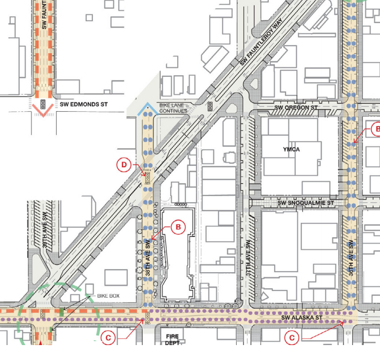
Just learned from the Department of Neighborhoods‘ e-mail newsletter that an SDOT project has grown: The West Seattle Neighborhood Greenway, previously planned for a route from SW Edmunds to SW Roxbury, will “extend the route all the way to SW College St.” That’s according to the city calendar listings for two upcoming “drop-in” meetings about the route extension, which to our knowledge has not otherwise been announced. So if you’re interested, here are the dates/times/places on the city calendar: 4:30 pm-6 pm April 9th at Uptown Espresso in The Junction (California/Edmunds/Erskine) and 10:30 am-noon April 14th at Hotwire Online Coffeehouse, also in The Junction (4410 California SW). We have an inquiry out to the project team to ask more about the extension plan.

P.S. If you’ve missed coverage of other greenways – the concept is explained here.

13 Replies to "West Seattle Neighborhood Greenway to be extended to North Admiral; drop-in discussions set"

  • Jort March 27, 2018 (6:28 pm)

    Ah, an SDOT project for alternative transportation! Wonderful!

    I’m assuming, given our history with these things, that this greenway will be half-completed by 2073, with the stipulation that it also include something like a parking garage or an extra freeway lane for some reason?

    • WSB March 27, 2018 (6:53 pm)

      We have had two built so far, roadblocks not expected with number three either. I did reach a project spokesperson late today and will be adding a map above. They’ll have an official announcement with more details soon. – TR

  • KM March 27, 2018 (6:44 pm)

    Hell yes. I visited a drop in session a year or so ago at the SW Library and it was a possibility at the time, so glad to hear they are going through with it. Now, please start construction yesterday.

  • Don Brubeck March 27, 2018 (9:30 pm)

    Good news!  This has potential to improve walking and biking between the Admiral Junction and the West Seattle Junction.  Along the way are Lafayette School, Madison Middle School, West Seattle High School, Hiawatha community center and park, Holy Rosary and Hope Lutheran schools, churches, and lots of businesses, apartments and houses.  With the Fauntleroy Boulevard project suddenly taken off the table for 2018, it’s good to see something added back (for 2020 ?)

  • chemist March 27, 2018 (11:32 pm)

    Well, that’s confusing.  Back in 2012 the Director’s Report plan for Fauntleroy Boulevard had the preferred greenway bike route heading N on 38th. 

    Then the most recent work on Fauntleroy Blvd had the potential greenway connection moving a few streets to the east, on 36th.

    Now it looks like the preferred route is to be somewhere between 44th and 40th, a few streets to the west of the 2012 Fauntleroy plan.

    • WSB March 27, 2018 (11:36 pm)

      https://www.youtube.com/watch?v=nt7-WKXL5vw

      But seriously … light rail was definitely not expected in 2012. And then the 2016 plan was based on one roughed out years earlier. We don’t have the new backstory yet – the Neighborhoods announcement of the drop-ins apparently was not supposed/expected to precede the forthcoming SDOT announcement.

    • Don Brubeck March 28, 2018 (7:52 am)

      @Chemist:  2014 The Bicycle Master Plan network map shows neighborhood greenways on 36th and on 42nd and/or 45th.  The exact street locations shown on the map are approximate. The BMP says that each route will be studied before final route is determined.  Moving the future route from 36th to 38th is an example of that. When the Fauntleroy Boulevard got into design, SDOT determined that 38th would work better than 36th,.  That’s still in the 20-year plan, but not scheduled yet, so may be more that five years out.

      Meanwhlle, most bike commuters will continue to use 36th from Avalon to Alaska. It’s not good with the angled parking, and really needs a safer intersection at Avalon/36th, but Fauntleroy is worse.

  • Jort March 28, 2018 (9:15 am)

    The soon-to-be-constructed (hopefully) northern end of the Greenway currently comes to a dead-end at 42nd and Edmunds. 

    This would be an excellent opportunity to apply traffic calming measures (including a mid-block crosswalk) to 42nd between Jefferson Plaza and the mid-block pedestrian plaza. Too many cars are racing through that side street in an attempt to avoid doing their duty and waiting at the Junction All-Ways Walk stoplight. It is time to make this a less attractive street for bad-behavior, cut-through cheater traffic.

    • KM March 28, 2018 (9:59 am)

      Yeah, that block needs a serious makeover. The wide lanes don’t help the speeding issues, and adding a mid-block crossing would be fantastic. 

      I’d also like to see u-turns banned on the the busier blocks  of the greenway, this block is a prime example.

      • chemist March 28, 2018 (11:24 am)

        The SPD will loan you a LIDAR gun to help document speeding for traffic calming.   I’ve not witnessed much of that, being a block with stop signs at both ends.

        • KM March 28, 2018 (5:30 pm)

          Mostly I’ve observed it for cars headed SB on 42nd. They get that speed from the little incline a block north and off to the races! Especially if they are running the light because they just can’t wait another cycle.

  • Don Brubeck March 28, 2018 (9:02 pm)

    @Chemist:  The 2014 Bicycle Master Plan is a 20-year plan. The annual “Implementation Plan” only looks ahead 5 years. So anything beyond 5 years will not yet be in an implementation plan.

    The funding and construction have not actually  been keeping pace with a 20 year build-out by 2035. Fauntleroy is not the only project that has appeared in the work plan, and then later disappeared.  Bike and pedestrian safety projects get a lot of public attention, but are just a tiny percentage of Seattle’s transportation budget, and construction costs have been escalating faster than projected in 2012-13 when the plan was developed.

Sorry, comment time is over.