West Seattle, Washington
25 Thursday

The snow that stuck a bit, briefly, this morning (as shown above on SW Sullivan in Upper Fauntleroy) is gone. The major roads look great for your drive home – we just came back from downtown via The Viaduct and The Bridge, both bare and dry. But the newest “forecast discussion” from the National Weather Service says this time tomorrow, beware (caps theirs):
THE REAL SNOW EVENT BEGINS LATE TUE AFTERNOON AND EVENING AS WARM FRONTAL PRECIP OVERRUNS THE COOL AND DRY LOW LEVEL AIR MASS. PRECIP WILL BEGIN AS SNOW AND SPREAD NORTHWARD AS THE EVENING WEARS ON…POSSIBLY MAKING THE EVENING COMMUTE QUITE MESSY. AT SOME POINT…LATE TUE NIGHT OR EARLY WED MORNING…WARMER AIR WILL MOVE INLAND WITH SNOW CHANGING OVER TO RAIN. TOTAL SNOWFALL AMOUNTS ARE QUITE DIFFICULT TO NAIL DOWN…BUT JUST ABOUT ALL AREAS SHOULD SEE ACCUMULATING SNOWFALL TUE EVENING.
So unless something changes – you might plan to leave for home earlier tomorrow, but don’t assume we’ll have a “snow day” Wednesday. Meantime, the government transportation agencies are putting out their alerts – from Metro, we have this roundup of their plan to be on “snow watch”.
5:29 PM UPDATE: Seattle Public Schools has sent a “robocall” informing district families that they’ll decide by 1 pm tomorrow whether to go ahead with afterschool activities or not.
9:31 PM UPDATE: The mid-evening forecasts are out and neither one of the forecasts we regularly consult is particularly snow-laden. National Weather Service has put up a Winter Storm Watch and is suggesting maybe 1-3″ in the metro area; weather analyst Cliff Mass thinks something more like a “dusting.”
(WSB video from the peak of this morning’s brief 8 am snow shower, added 8:19 am)
While there’s been a bit of snow overnight, and some showers continuing again now, it’s NOT expected to last much longer, according to the forecast – but be ready for some tomorrow. No major traffic problems reported (see the cameras below, and check more here):

(Refresh for latest pic of WS Bridge, looking eastbound, and 1st Ave. S. Bridge, more on the WSB Traffic cams page)
Clearing’s expected later – then snow is forecast to start late in the day on Tuesday. Also today: As announced Friday, Rachel Marie is back on the West Seattle Water Taxi run, which means Pier 50 arrivals/departures downtown again … two meetings of note tonight: North Delridge Neighborhood Council, meeting room at Delridge Library, 6:30 pm, and the citywide Skatepark Advisory Committee, 6 pm at Parks HQ downtown (with Delridge Skatepark on the agenda – as we reported Friday, it’s cleared for re-bidding) … West Seattle See Dogs invites anyone interested in raising a puppy to become a guide dog to join them at Merrill Gardens Admiral Heights (WSB sponsor) tonight at 6:30, 2326 California SW … And it’s opening day for Locöl, 35th/Kenyon, noon (here’s our report on its “soft-open” event last Friday night). Lots more on the WSB West Seattle Events calendar – and separate coverage if the snow shower lasts for long!
9:10 AM NOTE: … which it didn’t. And now the weather forecast has changed yet again. Now, we’re looking at some snow tomorrow evening, but then rain and wind after that … And weather analyst Cliff Mass is saying the same thing.
On-and-off snow showers continue this afternoon in West Seattle – never seems to be everywhere at once, according to the notes, texts, and calls we’ve received, plus our observation – but the National Weather Service‘s “special weather statement” is still in effect, updated at 5 this morning with the ongoing possibility of snow showers this afternoon/evening (as we’re seeing), and then that potential “snow event” at midweek. Latest word from weather analyst Cliff Mass is this update titled: Chances Of Major Snowstorm Fading. The NWS has just updated its four-times-daily “forecast discussion,” casting its own blanket of doubt, including: “Much has changed in the runs over the past couple model cycles making a very large snow event much less likely.”
Four times a day, the National Weather Service issues its “forecast discussion,” with a behind-the-scenes/crystal-ball-type look at what its meteorologists are seeing in the hours and days ahead. The newest one says snow showers are possible tonight/tomorrow, particularly on the highest hills, while also somewhat strengthening the possibility of serious snow around Wednesday of next week (though there’s still also caveats that with four days to go, things could change).
SUNDAY UPDATE, 5:20 AM: And indeed, the NWS’s “special weather statement” has just been updated to note the midweek uncertainty.
The National Weather Service has just issued a “Special Weather Statement” talking more seriously about the possibility of snow in the area – this weekend and around midweek. For Sunday morning, they’re suggesting “showery” snow – but then at midweek, there’s “the potential for a widespread heavy snow event somewhere in Western Washington.” You can read the “Special Weather Statement” here. P.S. There’s additional detail in the 3 pm “forecast discussion” from NWS – caps theirs:
THERE IS THE POTENTIAL FOR A WIDESPREAD…HIGH-IMPACT HEAVY SNOW EVENT FOR PARTS OF WESTERN WASHINGTON DURING THE SECOND HALF OF NEXT WEEK…BEGINNING AS EARLY AS WEDNESDAY BUT MORE LIKELY ON THU OR FRI. IT SHOULD BE STRESSED THAT GREAT UNCERTAINTY INHERENTLY REMAINS IN THE DAYS 5-7 FORECAST…BUT THE POTENTIAL CANNOT BE IGNORED.
Aside from two major showers, our last round of possible snow didn’t go much of anywhere. But it’s back in the forecast, so from the “just in case” perspective … The National Weather Service‘s “forecast discussion” mentions two possibilities — showers this weekend, and then one “model” hinting at a “classic snow pattern” around the middle of next week. Too soon to tell for sure, on either count, but forewarned is forearmed.

People who live in the 6000-6200 block of Beach Drive (map), by the slope that’s seen two slides in the past year, put out the alert on this; we went by for a photo, and it truly is the worst icy patch we’ve seen so far – it stretches a ways, and there’s a bend to its south, so you might come hurtling along without knowing you’re about to hit a long icy patch covering the entire road. This spot is shady all day long, too, because of the slope on one side and trees on the other, so until the air warms in a big way, it may not melt much. Wherever you go, beware ice – especially on the roadsides – almost anywhere in the shade. Rain and temperatures in the 40s may return Tuesday, per the newest forecast. P.S. (added 2:45 pm) Weather-related reminder: There’s a Stage 1 burn ban right now, which means no fires in your fireplace or wood stove unless you have no other way to keep warm, and also means no outdoor fires (beach, or otherwise).
ADDED 10:34 PM: We don’t know yet if it’s been blamed on the ice, but there’s been a crash within the past half-hour on that exact stretch of Beach Drive – reported as 5900 block, with scanner traffic discussing the significant ice on the road. No serious injuries reported.

Two images to remember this chilly last day of 2010 by … Robin Lindsey of Seal Sitters was out early this morning as always, checking the beaches, and caught the top image of paddleboarders, with the Olympic Mountains’ famous peaks The Brothers as a backdrop. Robin says it was so cold her fingers almost fell off! Next, Max shares a unique view, explaining, “We woke up to this delightful window decoration.”

The noon temperature at Sea-Tac and Boeing Field, by the way, was 32 degrees – up from the early 20s in both locations at 6 this morning.
Been outside tonight? All we can say is, brrrr. It’s in the 20s and the car tops were icing over by 9 pm. On the other hand, great stargazing. And according to the National Weather Service, this is what you can expect tomorrow night, too – so if you’ll be outside watching the Space Needle fireworks from West Seattle shores, or anyplace else outdoors, make sure your NYE fashion choice includes major insulation. (And if you’re still looking around to see what’s happening, remember our list – ranging from bar parties to church services.)
ADDED 12:15 AM: Our partners at the Seattle Times have published a preview with some behind-the-scenes info about the eight-minute Needle fireworks.
12:36 PM: Almost 12 hours after the only noteworthy snow shower – and it was a brief one, as we noted – there’s more falling right now, loud and sleety. (Five minutes later, the cars are covered in white – fleetingly.)
12:47 PM UPDATE: After about 10 minutes, down to flurry status. Added a video clip from the height of the shower. Newest forecast says we might see this off and on till midnight or so.

(Photo by Christopher Boffoli, before the icy bits all melted from atop cars)
1:06 PM UPDATE: The latest from SDOT, which notes we might have to worry about ice tonight (lows are projected in the 20s):
SDOT crews will continue patrolling and treating streets in the north end of Seattle today as needed although streets for the most part remain bare and wet.
Temperatures are forecast to drop below freezing early this evening with the possibility of up to one inch of snow or freezing rain. Crews will be out throughout the city to treat major arterial streets as needed and in preparation for the evening commute. Night crews will continue this work depending on conditions.
SDOT managers will closely monitor the weather throughout the evening and make changes if needed.
Drivers are advised to slow down this evening and tomorrow morning, and be prepared for ice, especially on bridges and other elevated structures.
2:09 PM UPDATE: And now it’s sunny! If we get any more showery weather, we’ll update this story rather than launching a new one. It’s clearly one of those days where the weather changes every five minutes and every five miles (if not less!).

Nice views from Alki this morning, during the first serious sunbreak we’ve seen in a while: The view of the frosted Olympics with low clouds in the foreground, above, is courtesy of David Rosen from SlickPix Photography; we caught the high tide at Alki, two perspectives below:


Checking the tide table, seems this isn’t even as high as it’s been – it peaks today at 12.4 feet in a few minutes, but the highest tide of the month was 13.2 feet on Christmas Day. P.S. Note the 8 pm -1.2 tide this Friday – if the weather holds, might be a nice low-tide walk for New Year’s Eve.
12:59 AM: Thanks to WSB contributor Deanie Schwarz for the first heads-up – a sort of snow/sleet mix has begun to fall. Meantime, Stephanie saw an SDOT de-icer truck on the West Seattle Bridge right before midnight, as the city had promised. Official Sea-Tac 1 am temperature is 38 degrees, so it’s a little too warm to stick, so far.
1:13 AM NOTE: First shower over already – radar a couple over ago had suggested whatever comes, will be in showery installments, like this.
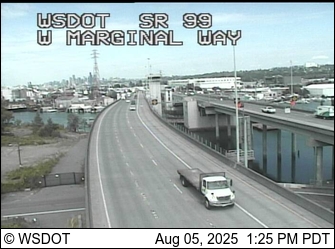
5:29 AM UPDATE: Nothing much through the night here in West Seattle. Checking out TV traffic reports, looks like South Everett has snow right now. (See this WSDOT camera.) So if you commute in that direction, be ready! Tacoma had a shower, too, but it’s stopped there.
8:15 AM UPDATE: Uneventful in-city commute. New forecast (from National Weather Service at 7 am) says showers are still a possibility.
ORIGINAL 12:48 PM REPORT: Just in from SDOT:
The Seattle Department of Transportation (SDOT) is carefully monitoring weather forecasts for Seattle and planning for snow and ice response accordingly. The forecast is for temperatures just above freezing overnight with up to one-half inch of wet snow possible, and an additional one inch of snow possible tomorrow (Wednesday) morning.
After 10 p.m. tonight SDOT crews will proactively apply salt brine in roadway areas where frost or black ice is prone to develop, especially on bridges and other elevated structures around the city.
Starting at 4 a.m. tomorrow morning (Wednesday), SDOT spreader trucks will be prepositioned throughout the city, ready to spread rock salt on major arterial streets (primary snow routes, Levels 1 and 2) for the morning commute if conditions warrant.
The snow plan calls for plowing when there is more than one inch of accumulated snow on the roadway, which is not in the forecast at this time.
SDOT will continue to monitor the weather conditions carefully and respond accordingly.
For more information on Seattle’s winter weather response plan and to view a map of snow routes, please see SDOT’s website.
2:07 PM NOTE: Meantime, the National Weather Service’s “forecast discussion” is still downplaying the likelihood of some snow – another update should be out within the next two hours; whatever happens, they say, would be overnight into the early morning. And WSDOT has announced it’ll open the I-5 express lanes southbound at midnight, just in case.
ADDED 3 PM: Metro has weighed in:
With snow showers in the forecast for Wednesday morning, King County Metro Transit is urging bus riders to prepare by making sure they are signed up for Transit Alerts and that they know the snow routing for the buses they will ride tomorrow.
Then before traveling, riders should check kingcounty.gov/metro/snow for the most current status of Metro service. Updates to the online information will begin at 4 a.m. each morning.
Remember, Metro is operating with a reduced schedule this week, which means some commuter and school-oriented routes do not operate, and other routes have individual trips canceled. This is indicated by an “H” in the timetables.
Current weather forecasts indicate if snow falls Tuesday night into Wednesday morning in the lower elevations of King County, it should be mostly in the form of snow showers with no significant accumulations. But, the snow could be heavier at higher areas in east King County or if a convergence zone sets up inside the county. Bus operations could change rapidly.
We’ll be on early/late watch too, as always, including 1st word from Metro in the morning re: their plans.
The afternoon “forecast discussion” from the National Weather Service goes so far as to say, “…want to emphasize that this situation will not be like that of what occurred across much of the interior lowlands back in November.” But that said, the forecasters think it’s looking likely that some snow will fall overnight Tuesday night into Wednesday: “Much of the lowlands will likely see some snowflakes late Tuesday night or Wednesday morning. Any snowfall amounts, though, will be light or less than [an] inch.” The Seattle Times (WSB partner) reports SDOT will likely decide tomorrow morning whether to fit its trucks for snow/ice duty, just in case.
10:27 PM UPDATE: Weather analyst Cliff Mass has published an update; he doesn’t think we have much to worry about.

(Alki rainbow, from Russ via Twitter, added 2:47 pm)
The sudden wind and rain are the subject of a “short-term forecast” alert from the National Weather Service, which says we might see gusts up to 40 mph during the next few hours before this finishes moving through. (And the “possible midweek snow” alert we mentioned last night is still in effect.)
2:47 PM NOTE: Still blustery! And looking ahead to that possible snow, the newest forecast is targeting Wednesday late afternoon and beyond, with a snow level around 300 feet.
First saw a mention at KING5.com, then noted it’s also part of the newest “forecast discussion” from the National Weather Service: There’s a chance of lowland snow around here at midweek, forecasters say. Enough of a chance that the NWS has just issued a “special weather statement” about it – read it here. Excerpt (caps theirs):
THERE IS A CHANCE OF LOWLAND SNOW BEGINNING ABOUT WEDNESDAY AND LASTING INTO THURSDAY NIGHT. A DEEP UPPER TROUGH WILL SETTLE OVER WESTERN WASHINGTON. PRECIPITATION WILL BE SHOWERY AND WILL DIMINISH BY THURSDAY. HOWEVER IT IS LIKELY THAT AT LEAST SOME OF THE PRECIPITATION WILL BE IN THE FORM OF SNOW. WITH HIGH TEMPERATURES IN THE 30S AND LOWS IN THE 20S…SOME OF THE SNOW WILL STICK.
THIS SNOWFALL IS STILL FOUR DAYS AWAY AND THE FORECAST COULD CHANGE.
(Seems Cliff Mass mentioned this last night, too.)

We’re midway through – more or less – the first lunar eclipse/winter solstice combo in 362 years (and the last one till 2094). Many around West Seattle got at least a glimpse of the disappearing moon, thanks to shifting clouds. Christopher Boffoli got the image above from The Junction within the past hour. As you might imagine, America’s space agency had its pick of angles …
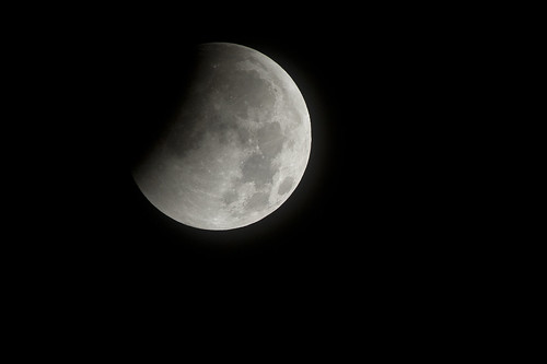
NASA’s Bill Ingalls took that from Arlington, Virginia. Anything else comes in later, we’ll add – we’ve seen a lot go by on Twitter (like this one), and various galleries like this one. Coming up, there’s the winter solstice itself: West Seattle’s NASA Solar System Ambassador Alice Enevoldsen plans a sunset-viewing event tonight (Tuesday) at Solstice Park (map); 4:20 pm’s the sunset, she’s planning to be there around 3:30, unless it’s rainy (but clouds do NOT cancel – just like tonight, you never know when you’ll get a peek).
ADDED MIDDAY TUESDAY: This eclipse photo is by DLC (thanks!):


Considering how windy it was all night long – we kept watch from midnight till almost 6, surprised West Seattle escaped major power problems this time – it’s no surprise at least one tree was lost. This one is in Arbor Heights, a 40-footer brought down by the 40-mph-ish overnight wind, according to John. The current forecast only suggests breeziness and showers for the next few days. 1:53 PM NOTE: That said, it’s “showering” and gusting fairly impressively at the moment …

While it’s by no means unusual to spot stand-up paddleboarders off Alki and other West Seattle beaches, this time of year they’re usually a little more covered-up than these two. Thanks to JayDee for sharing the pic (before the clouds moved in) – he points out the air temperature at the time was 48 degrees. (Just a bit cooler than the 50-degree water temperature.) Forecast, you ask? Windy after midnight; rain returning tomorrow.
In case you were wondering: We checked in with SDOT this afternoon on two post-storm road issues. SDOT spokesperson Marybeth Turner sent answers. First, on the Beach Drive slide:
SDOT has a bit of work to complete on Beach Drive SW. Crews will continue working on it tomorrow. Until then, the roadway will remain restricted to one shared lane.
Second, we asked about the strategy for re-filling the potholes that lost their fill during the deluge – we noticed multiple cases along Alki Avenue SW while driving around on Sunday morning, and published this photo in our ongoing coverage that day:

The SDOT reply:
Thanks for asking about potholes. We are receiving lots of pothole requests from all areas of the city, at times several reports for the same pothole. We have crews out in force to fill them.
If you want to report one – 206-684-ROAD, or use this online form.
Today there’s so much going on that we are going to have to present storm-related news in multiple stories interspersed with non-storm stories, rather than one long-running narrative. (Our overnight report is here; earlier coverage of a tree on a Westwood home is here.) A WSB’er (who didn’t want credit) shared that phone video of a transformer explosion in North Delridge near Longfellow Creek; he says, “Actually the transformer caught on fire and burned with a very intense white and blue light – we first thought it was the Police at the scene, but the light was too bright for that. It kept on burning and blowing every 2-3 minutes until it stopped. It blew up at least 2-3 times.” Meantime, the bursts of rain and wind keep taking out trees – we were at the Southwest Precinct along Delridge for a non-storm-related event when we got word of tree trouble nearby – here’s all that was left by the time we got out:

That’s on the west side of Delridge, south of Webster, across from the precinct. Thanks for the ongoing updates that are being shared in multiple ways – we’re seeing another wave of rain and wind now, after some sunshine, so it’s not over yet.
12:06 PM UPDATE: 911 log shows a “wires down” report in the 3200 block of Alki SW, which is on Alki Point.
12:41 PM UPDATE: Speaking of Alki Point – this carrier just passed it (note the rainbow off to the right):

Thanks to JayDee for the photo. Greg D shared a somewhat-closer picture from Alki Beach, close enough to see the number and verify his belief it’s the USS John C. Stennis, currently based in Bremerton (CVN 74).

It seemed inevitable in the heart of the crazy early-morning storm burst (here’s our original coverage) that trees had come down somewhere – and here’s our first report. Just received the photo from Jacque and Zack in Westwood, who e-mailed, “We had part of a tree come down onto our neighbor’s house after the windstorm. We’re on the phone with insurance and scouting the forums to get recommendations for arborists.” (If you have anyone to recommend, please post a comment!) Also just got word from Tiffany of slide activity spotted alongside Admiral: “Heading 1/2 to 2/3 the way down Admiral Way you’ll see up the hill, looks like recent slide activity and even fresh dirt over the wall and bulges of mud at the top!!!”
ADDED 9:18 AM: The stormy weather has its beautiful moments too –

Taken within the hour, before everything clouded up again, by someone in Gatewood who asked to be anonymous. (Looks like the “pot of gold” would be on Blake Island for this one …) Thanks!
ORIGINAL 12:31 AM REPORT: Both for those who are awake, and for those sleeping through this who might wonder in the morning “what happened?” – after several bouts of thunder, there’s a massive downpour and strong wind right now. And power flickers.
12:43 AM: 911 log says there’s a transformer fire at 26th/Juneau in North Delridge. Meantime, just added video we got by stepping out the door- under the eaves, sheltered by a big shrub – during that huge rain/wind gust. You can only see a peek of it through the shrub but at least we captured a bit of what it was like, for those who somehow slept through it. The National Weather Service has a “short-term forecast” alert about this – apparently will NOT be an encore:
A STRONG LINE OF SHOWERS AND ISOLATED THUNDERSTORMS ASSOCIATED WITH A STRONG COLD FRONT WILL PRODUCE BRIEF SOUTHWEST WIND GUSTS TO 55 MPH AS IT PASSES. AT 1130 THE LINE EXTENDED FROM WEST OF PORT ANGELES TO WEST OF SHELTON THEN DOWN ONTO THE NORTHWEST OREGON COAST. THE LINE IS MOVING EAST AROUND 65 MPH AND WILL MOVE RAPIDLY INTO THE CASCADES BY 1245 AM.

12:58 AM: Added that photo, taken by Mike Heavey from Alki, and shared via Twitter. Our power’s still flickering. One commenter says there’s an outage near Westwood Village. 911 log shows a transformer fire at 26th/Juneau in North Delridge. Via Twitter, we’re also told of a Harbor Avenue outage. The City Light outage tracker hasn’t caught up to those yet – it’s showing more than 6,000 without power from White Center southward, nothing up here yet.
1:31 AM UPDATE: No major reports of trouble – although if the Big Burst brought down any more trees/mud, we may not hear about it for a few hours. The transformer-fire call at 26th/Juneau is closed.
6:57 AM: City Light shows no major outages left in West Seattle right now – though more than 700 are out in other areas of the city. No reports of any new road trouble; Christopher Boffoli drove around potential trouble spots and major local roads after things calmed down a bit overnight and didn’t see anything likely to get in the way of drivers.
| 18 COMMENTS