West Seattle, Washington
19 Friday

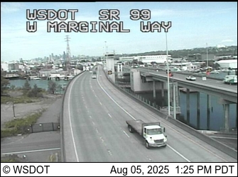
(Refresh for latest pic from WS Bridge & 1st Ave. S. Bridge cams, more on the WSB Traffic page)
5:31 PM: We are in Admiral, heading south, and it’s snowing, though not too heavily. You?
6:02 PM: Back at HQ in Upper Fauntleroy, it’s very, very light. Moving the bridge cameras from our morning preview to this story for anyone who still has to hit the road(s).
6:18 PM: Steady, still not heavy. Meantime, an update from the city Emergency Operations Center just arrived in the WSB inbox, including:
19 plow trucks with salt spreaders are pre-positioned around Seattle. Snow routes have been pre-treated with magnesium chloride salt brine, emphasizing elevated structures. The department has been working 12-hour shifts for 24-hour operations since 9 a.m. this morning.
(We noticed pre-treatment marks on arterials including SW Thistle when we headed north pre-sunset.) The city also says that so far, Thursday is expected to be “a normal day for garbage, recycling, and food/yard waste collection,” so please have everything out by 7 am.
(Video added 6:53 pm)
7:38 PM: Bigger flakes. Meantime, the city reports it’s closed the EOC until 5 tomorrow morning, at which time it’ll monitor the morning commute.

8:18 PM: Cars are coated in snow up here in Upper Fauntleroy, after two-plus hours of steady snowfall. Yards/planting strips are frosted too. Not the street, so far, but temps are close to freezing. Note that while it’s not so bad around here, to the north and to the south, different story, so if you have to drive into Snohomish or South King County (among other areas) … be forewarned.
9:04 PM: Metro has now announced all its Southwest King County buses are on snow routes. Some of them go through White Center. West Seattle is mostly still on regular routes, though, but keep an eye on the Metro map/list.
9:51 PM: The weather experts are in with their late-night thoughts. About an hour ago, Cliff Mass warned “it’s not over yet.” But the National Weather Service has downgraded the “winter storm warning” to a “winter weather advisory” for Seattle. As you have likely seen elsewhere, there’s been major snow to the north, and to the south, but ours hasn’t amounted to much more than a hearty dusting.
10:43 PM: And suddenly we’re having the heaviest shower we’ve seen all day/night – with some sticking to the road. Perhaps Cliff Mass was right. (video added 10:59 pm)
12:41 PM: Moving up from the south – we were just in White Center, where it started to snow; headed back toward West Seattle and now it’s a pretty good shower in Westwood.

12:53 PM: We’re in Highland Park and the snow shower has just stopped … no, wait, flurrying again … Speaking of Highland Park, if you didn’t see this in the WSB Forums, by the way, Zippy’s is closing at 2 pm just in case.
1:02 PM: Sunny in Fauntleroy! Seriously. So we’re moving on with the rest of the news and will bring snow coverage back to the top as warranted.
4:19 PM: Still no snow sightings since then, though the clouds have grow a bit darker.
12:01 PM: Since the flake-free night gave way to a flake-free morning in West Seattle, we’re checking around to see what the weather folks are predicting for this afternoon. The popular weather analyst Cliff Mass published a “nowcast” this past hour on his website, acknowledging areas like ours have been in a shadow while other areas (like Snohomish County) have been walloped, but saying that pattern is now breaking down. However, he says in capital letters, “THIS WILL NOT BE LIKE NOV. 22ND.” As for the National Weather Service, its midmorning “forecast discussion” also acknowledges the “shadowing” but predicts for later today, “SHOWERS WILL INCREASE … AND AN INCH OR TWO OF SLUSHY SNOW WILL OCCUR MOST AREAS AWAY FROM WATER AND ABOVE 100-200 FT IN ELEVATION.” The broadcast translations of most of this are discussing mid-afternoon or later. The NWS warns that the “models” remain inconsistent, but tonight looks even potentially snowier. So don’t assume nothing’s happening because nothing’s happened yet – might, or might not. (Yes, we know, we’ve seen this all before.)
ADDED 12:06 PM: Just after we published our update, Metro sent theirs. No route changes yet, but they’re chaining up and warning they expect to move to snow routing later – info after the jump (and we’re watching for other transportation/transit agencies’ plans too; will add to this story as they come in):Read More
(WEDNESDAY MORNING NOTE: The storm warning was slightly amended late last night but is still in effect; see the new version here.)

(Photo taken 6:25 pm, sleet/hail/ice pellets/etc. still on the ground outside Southwest Precinct)
5:23 PM: As another brief shower of sleet/hail/ice pellets/snow/etc. passes through, the major transportation agencies are ending the day with advisories to be ready for anything tomorrow. Here’s the Metro advisory; here’s the Sound Transit advisory. But at this point, those are mostly intended for tomorrow morning; we’re not expected to get major snow in West Seattle tonight (we’ll update, of course, if that changes, and thanks in advance for sharing news of what you’re seeing where you are). The National Weather Service has raised the alert level to “Winter Storm Warning,” though, with this declaration:
A DEEPENING UPPER LEVEL LOW COMBINED WITH ARCTIC HIGH PRESSURE THAT WILL BE MOVING INTO THE AREA FROM THE NORTH WILL GIVE SNOW LATE TONIGHT THROUGH THURSDAY TO ALL OF WESTERN WASHINGTON… INCLUDING THE LOWLANDS.
5:40 PM UPDATE: From the mayor’s office:
The latest weather forecasts call for snowfall of 2 to 6 inches beginning Wednesday afternoon, followed by freezing temperatures through the end of the week. That pattern is very similar to the snowstorm that hit Seattle during Thanksgiving week last year. While we learned a lot and made improvements following that storm, it’s impossible to predict exactly where and how this week’s storm will hit hardest.
With that in mind, we are activating the city’s snow and ice plan. The Seattle Department of Transportation began by pre-treating streets with anti-icing solution today. Crews will go to 24-hour work shifts beginning Wednesday morning. Because Wednesday afternoon’s commute is expected to be difficult, it may be a good day to work an alternate shift, telecommute or make other travel arrangements if possible.
5:48 PM UPDATE: And SDOT is out with its own statement, including snow-plan specifics:
The Seattle Department of Transportation (SDOT) is gearing up for snow expected to arrive in the Seattle area on Wednesday, February 23. As of 4 a.m., ten snow plows will hit the streets in the north sector of Seattle and eight plows will move into action in the south sector. Starting at 9 a.m., SDOT will go into a full 24-hour response plan to keep roads open, buses moving and critical emergency services accessible.
The response plan calls for deploying 30 trucks with plows, which will be prepositioned throughout the city in key locations such as elevated structures and certain trouble spots on major arterials. The department starting pre-treating major roadways with salt brine this afternoon in preparation for the storm. Additional details concerning SDOT’s response will be forthcoming as more information about the impending storm becomes available.
Motorists are advised to use caution when driving in snow and ice, especially on Seattle’s many hills and bridges. For up-to-date information on the City’s response and roadway conditions, please visit: http://Seattle.gov/transportation/. Motorists can also check on current traffic conditions and roadway images on SDOT’s Traveler’s Map.
As a reminder, property owners are responsible for clearing sidewalks adjacent to their properties after a snowstorm. SDOT encourages residents and businesses to have snow shovels and materials on-hand to keep walkways clear and safe for pedestrians.
ORIGINAL 12:33 PM REPORT: The National Weather Service has us under a Winter Storm Watch as of midmorning (read it here), and weather analyst Cliff Mass is just out with his take, which begins ominously (or cheerily, if you are a snow fan): “Folks, this is serious.” Unsettled weather is continuing as we speak – watching Twitter, brief sleet/hail/snow-type showers have cropped up this past hour from Ballard to Silverdale – but the major snow threat kicks in tomorrow morning, according to the NWS. Updates to come!
1:37 PM UPDATE: A few flakes are flurrying here in Upper Fauntleroy at the moment. (And a few minutes later – it’s picking up a bit.)
 The forecast and “special weather statements” warned it would get wintry – and it just did. Via Twitter, Diane reports 10 minutes of snow in Admiral. We got sleet – enough to briefly whiten the car top/hood and part of the street (iPhone photo at left) – here in Upper Fauntleroy. Kim says it was just rain in The Junction. The latest weather predictions suggest the best chance of bonafide snow is Wednesday night/Thursday. Here’s the newest “special weather statement” detailing the potential timeline; here’s the latest analysis, and some recent sightings, from Cliff Mass. And if you’re still confused about the difference between hail, sleet, graupel, snow, and other types of frozen precipitation – maybe this’ll help.

(Photo by Mark Pierson)
It didn’t happen last time – but just in case it does this time, you should know the National Weather Service issued another “special weather statement” late last night warning about the chance of snow showers this week. Cold air and incoming systems suggest this might happen any time between tonight and Thursday, and snow or no snow, it’s going to be cold, with lows possibly in the 20s Tuesday, Wednesday, and Thursday nights.
(Saturday night note – another roundup in the works with today’s great photos – editor@westseattleblog.com if you have one to share)
Before we move on to the rest of today’s news, more photos of this morning’s confluence of high tide, north wind, and full moon (thanks to everyone for sharing!) … Above, Cormac captured the seaspray at Alki. Someone else who lives near Alki Point e-mailed to say it was so fierce early this morning, they were getting soaked on the second floor of their building. From a bit more of a distance, David Hutchinson sends this rosy view of the Olympics and a choppy-sea-navigating tugboat:

David reported it was about 34 degrees (before the wind chill!) when he sent that. (added) Later in the morning, Danny McMillin photographed the wave action, with Mount Constance towering overhead:

And how about one more shot of the moonset?

That’s courtesy of Leaf, taken along Beach Drive. If you want to see something close to any of the above again – tomorrow morning just might bring a repeat – except for the part about the gusty wind. The tide will be a bit higher than it was this morning when it peaks just after 6 tomorrow morning; the Sunday forecast looks just as clear as today.
Though the air temperature isn’t close to freezing, the National Weather Service is warning of potential snow showers, because of a weather phenomenon that is “dragging” snow levels to sea level – the city’s covered by this advisory; read it here.
Another “Special Weather Statement” out within the past hour from the National Weather Service – this time warning we might see thunderstorms again today. (Here’s our report from last night, with photos of the trees taken down by the wind that roared through on the heels of more ground-softening downpours.)

(Photo by Katie Meyer for WSB – tree down at Oregon/Glenn in The Junction)
As the wind kicks up again tonight – the National Weather Service has just issued a “special weather statement” warning of gusts up to 55 mph – we’re checking out a tree reported to have been blown down in The Junction. (Added: See comments for more. We’re still working on visuals. There’s also a tree down in the Morgan Junction area.)
7:39 PM UPDATE: The “special weather statement” has now been canceled – so the worst is over.

8:41 PM UPDATE: Added that photo, also by Katie, from the tree that hit a house on Holly Place in the Morgan Junction area. The homeowner told Katie they weren’t home when it happened; a neighbor called for help after seeing wires sparking. The damage is not reported to be major.
9:40 PM UPDATE: And now … thunder. Not mentioned in the current forecast, though…

(Photo of wave vs. rocks by Harbor West on Beach Drive, by Stephanie Brownfield)
A few hours after the wind kicked up in a big way (as we noted on Twitter), the National Weather Service finally declared a “wind advisory” that’s in effect till 9 pm tonight. The NWS warns of gusts up to 50 mph. There’s already been one outage in West Seattle, fewer than 100 homes/businesses in Arbor Heights, just south of Roxbury and mostly east of 35th, recently restored according to the City Light tracker.
You might have heard those rumblings about a bit of snow possibly on the way. The National Weather Service has escalated the rumbling to “Special Weather Statement” status (see the brand-new version here). But they caution it isn’t likely to be much, and isn’t expected to arrive before very late tonight/early tomorrow.
7:20 AM SUNDAY: The chance appears to have evaporated – the “special weather statement” is no longer in effect.

In the middle of a day full of very-serious stories, and before the impending sunset (looks promising!) renders these photos REALLY old news, we wanted to share two pictures of the amazing sunrise. Thanks to Cormac M (top photo) and Susan R (next photo) for sharing!

More news to come …

Hope you were up early (or late) enough to see this morning’s amazing moonset. In case you weren’t – Gatewood photographer Long Bach Nguyen has shared two beautiful photos (thanks!).

(LAST UPDATE, 9:28 AM: Metro just returned to regular routing. No major road problems – but lots of puddling where snow is blocking drains. Forecast warns of urban flooding. Many schools delayed 1 or 2 hours; we are updating the list frequently – see below)

(Refresh for newest pic from WS Bridge [looking eastbound] and Junction; more cams on WSB Traffic page)
The melt-off is well under way. But many will still be affected this morning by the aftermath of last night’s snow:
FORECAST: An urban flooding advisory is in effect because of the melting snow and puddling water as rain continues. Breezy too.
BUSES: **Update, 9:28 am** – Metro has returned buses to regular routing … Sound Transit says Route 560 remains on a “modified snow reroute.” … 8:19 am note: Andy points out the 54 was delayed 10 mins by the low bridge opening for marine traffic.
SCHOOLS: Seattle Public Schools are opening 2 hours late, with buses running on *regular* bus routes (per 5:10 am robocall; read full SPS message on schoolreport.org – and note this means a previously scheduled early release at Madison MS is ***canceled***) … South Seattle Community College in West Seattle is starting 2 hours late. … Holy Family School in White Center is starting 2 hours late. … Vashon public schools are 2 hours late. … Highline Public Schools, 1 hour late … Westside School starts at 9:30 am … Seattle Lutheran High School starts at 10 am … Hope Lutheran School is 2 hours late … Kennedy High School starts at 10:30 am … Shorewood Christian starts at 10 am … NO CHANGES at West Seattle Montessori (we just called) or OLG … Explorer West starts at 10 am … Community School of West Seattle is 1 hour late … Arbor Heights Co-op Preschool morning classes canceled … If you know of a school change we haven’t mentioned here yet, please let us know.
ROADS: Still no trouble reported (as of 6:28 am). Official report from SDOT at 4:43 am:
Two to six inches of wet snow accumulated on Seattle streets between 7 pm and 1:30 a.m. last night and this morning. This morning it is raining and the snow is mostly slush. The West Seattle Bridge and the Alaskan Way Viaduct as well as many arterial streets are bare and wet. Other streets have accumulations of slush and there is standing water in places. SDOT crews have been plowing major arterial streets in Seattle and continue to do so this morning, applying salt where needed to speed the melting of slush. …
More commute reports in the comments (thanks for sharing info!). (added) 9 am SDOT update:
Street Maintenance crews worked throughout the night clearing up to six inches of wet snow and slush from major arterial streets around the city. This morning crews are clearing slush that remains on some arterial streets, especially at the tops of hills. Also, more than 30 SDOT employees are clearing street corners in high priority areas such as around hospitals and in business districts.
SDOT asks drivers to use caution when driving where there is still slush on the roadway making the streets slippery, and to be on the lookout for standing water. Residents and businesspersons are asked to check the drains near their homes and businesses to make sure the drains are not blocked by debris so that water can enter easily. Also, residents and businesspersons are encouraged to clear slush from the sidewalks around their property to enable pedestrians to pass by safely.
TRASH/RECYCLING/YARD WASTE: E-mail from the city at 6:13 am says it’s on REGULAR SCHEDULE today, so if you have Wednesday pickup, put it out as usual. … Allied, though, has some changes.
WEST SEATTLE GOLF COURSE CLOSED: Per tweet from Seattle Parks, too much rain for golfing, too little snow for sledding.
More updates as we get them!
From Christopher Boffoli – Junction scenes comprising a West Seattle video souvenir of the short-lived Tuesday night (and a bit into Wednesday) snow.
(11 PM TOPLINE: Trouble reported on many West Seattle hills; stalled buses reported, and Metro says all buses are on snow routes. Forecast still says this will switch to rain before you wake up tomorrow. Scroll down for newest info/pictures)


(Refresh for latest images: From left, ‘Walking on Logs’ area, WS Bridge east of 35th, west entrance ‘low bridge’)
8:08 PM: About half an inch of snow on the ground – and on cars (our unscientific measurement above) – in The Junction, where we just left a meeting:

By all accounts, including Facebook and Twitter, it’s snowing pretty much everywhere in West Seattle. En route back to HQ. Bill reports he just saw a salt truck go by at Marine View and 102nd. Keep the snow reports coming!
8:18 PM: Heading slowly southbound on California SW. Now south of The Junction – it’s sticking, albeit lightly and quite driveably so far, on California. The snow is still steady, but not falling that heavily.
8:34 PM: Made it back to HQ. Going up the California SW hill south of Morgan Junction was fine – as long as you drive slowly – the usual snow advice for hills. Meantime, Richard e-mails to say that even by the water, Brace Point area, there’s up to about half an inch on the ground. From High Point, Jennifer tweeted this photo of her dogs out in the snow (Jessie and JoJo):

From Puget Ridge via Facebook, Christina says about an inch of snow has fallen:

No recent forecast updates, but within an hour or so we should hear what the National Weather Service thinks about the prospects this will progress the way most had predicted, with rain arriving overnight.

9:07 PM UPDATE: Added traffic cameras at the top of this item – and a photo immediately above, looking down at Jefferson Square entrance on 42nd, via Twitter from Cindy. Also getting an update on Junction conditions, from Christopher Boffoli: “1-2 inches on the ground here now. No evidence this section of Cali has been salted. People fishtailing and spinning out. Traffic is actually pretty heavy too. Every bus I’ve seen has had chains. They seem to be OK.” That coincides with an advisory just in from SDOT, saying they’re “transitioning to plowing roads.” Also a note from our snow-country-raised co-publisher, who’s heading uphill from lower Fauntleroy: This is “dry” snow.
9:26 PM UPDATE: Co-publisher reports people stuck and spinning out on the California SW hill south of Morgan Junction (as does Kae via comments) and sent this photo:

We also have a report of bus trouble – two of them – on SW Barton in Westwood/Roxhill area – thanks to Dana for this view:

9:49 PM UPDATE: More photos coming in. First, Trick caught this screen grab from one of the SDOT cameras we have “live” atop this story – the “Walking on Logs” spot alongside the southwestbound Fauntleroy end of the West Seattle Bridge – he points out the salt/sand truck!

And from Charles, a look along Avalon, toward SW Yancy (and WSB sponsor Stor-More) on the east side of the street:

Meantime, via Twitter, @reallowvibe warns that the Admiral hill is trouble now too. Again, just about every hill should be avoided right now, unless you happen to have seen a plow. It’s still snowing steadily out there, and the wind direction has not changed in the direction that would portend this ending any time soon. And from Cindi on the SW Morgan hill between 35th SW and Morgan Junction – “From the top of the hill, I’ve already seen cars going down have serious problems, it’s very slick. A police car was spinning his wheels going up – that was about an hour ago.”
10 PM UPDATE: Metro says all buses are now on snow routes. National Weather Service still promises rain by the time you wake up tomorrow:
FORECAST IS FOR THE SNOW TO CHANGE TO RAIN DURING THE NIGHT AND NO CHANGES TO THAT IDEA. THE WHOLE PROCESS WAS A LITTLE SLOWER THAN EARLIER MODELS HAD IT…WITH A LATER ONSET TIME AND THEREFORE A LATER CHANGE OVER TIME. STILL…BY MORNING SNOW WILL HAVE CHANGED TO RAIN JUST ABOUT EVERYWHERE. THE ONLY EXCEPTION MIGHT BE THE WESTERN WHATCOM COUNTY ZONE…WHERE THERE IS A WINTER STORM WARNING IN EFFECT MAINLY BECAUSE SNOW THERE WILL LAST THE LONGEST.
10:31 PM UPDATE: Two video clips in from WSB’ers – top, that’s Alex’s view of The Bridge from the west; next, a view from Fairmount:
Snowflakes are getting bigger here, which our resident snow expert says means the snow’s getting wetter – which would have to happen before the predicted turn-to-rain …

11 PM UPDATE: That photo from Keva shows a plow just south of The Junction. We’ve also heard about a plow sighting in the Alki area. Plus, another bus problem – the westbound 56 reported stalled atop the eastern Admiral Way hill, around 37th and Admiral.

11:25 PM UPDATE: Before the snow makes way for rain – there’s a fun photo – Laura Matheson says her kids Julia and Rebecca were ready to start building a snowman as of about 9 pm, with two inches by then on “High Point Hill.” Looking outside, we seem to have between 2″ and 3″ here in Upper Fauntleroy, but sleet is starting to creep in with the snow – you can hear the precipitation now, and pure snow is usually fairly quiet. But we all saw some, even Beach Drive, where Linda Ann took this photo:

The major concern we’ll be watching for the morning commute … how fast will this all wash away? SDOT’s been working hard on the West Seattle Bridge, so even if there’s still snow around your house, there’s some hope the major commute routes will be OK in the morning.

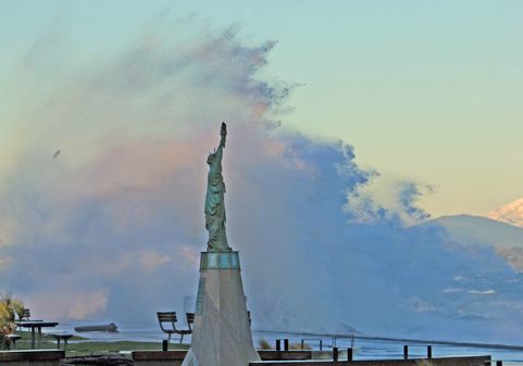
12:47 AM: We’ll be starting an overnight report shortly, to cover the hours till the morning commute. Meantime, lots of plow and sander activity here by headquarters – have heard the trucks go by numerous times. And a few more photos to share – thanks to SA for Alki’s Lady Liberty, the frosted version, above. (added) We caught one of the plows westbound on Thistle to northbound California; it continued to work California, back and forth, even the non-arterial section south of California, for a while thereafter:
(7:56 PM TOPLINES: NOW it’s snowing notably … will start another update soon, adding some visuals below)

3:38 PM: We’re now kicking off our afternoon “snow or no?” coverage. Above, the snowplow that SDOT has “pre-positioned” in West Seattle, parked at 38th/Alaska when we caught up with it a little while ago. SDOT says it’s ready, WSDOT says (for state highways) it’s ready, Metro Transit says it’s ready.
(Refresh for latest pic from WS Bridge camera, looking eastbound, and Junction cam, more on the WSB Traffic cams page)
3:55 PM UPDATE: Here are the school changes we published earlier. West Seattle Little League president Mark Terao just e-mailed to say tonight’s registration session is CANCELED, because of Seattle Public Schools (there’s another session set for next Tuesday, January 18). Seattle Parks, meantime, says community centers and pools are operating **normally** until and unless weather requires a change in that decision. One event cancellation so far: nrg day spa‘s Grand Opening is postponed till Thursday night, during the West Seattle Art Walk.
4:09 PM UPDATE: Weather analyst Cliff Mass is about to release his “nowcast” – but for starters says, “Nothing is happening right now. No need to rush home, or anywhere else.” (Added) It’s out. He says nothing imminent for at least two hours in the metro area:
Bottom line: you don’t have to rush anywhere if you are living in western Washington. No imminent significant snow for next two hours. The satellite suggests a more intense band offshore that would come in during the evening…but can’t be sure. At the same time it is warming aloft as we speak. Stay at work. Enjoy happy hour. WSDOT doesn’t need to be concerned about a rush-hour mess.
4:43 PM UPDATE: Metro is chaining buses, still just as a precaution. One more cancellation: West Seattle Community Orchestras’ rehearsals/meetings tonight.
5:24 PM UPDATE: The weather’s still calm, at least here in the city. A smattering of snow reports elsewhere – such as Bellingham, Whidbey Island, Hoquiam. Forecasters still say we’ll see some, at some point, but are sticking to the “rain by very early morning.”
6:30 PM UPDATE: A few flakes were falling as we left Fauntleroy bound for a meeting in The Junction, but they stopped mid-Gatewood. Keep us posted with what you are seeing – or not seeing – where you are. (added a few minutes later) Via Facebook and Twitter, we’re getting snow reports from most spots around West Seattle – except, so far, at sea level.

7:56 PM UPDATE: Snowing notably in The Junction. Will add a photo in a moment. Will start a new story soon, too.
1:01 PM: Just in from Seattle Public Schools via robocall – all afterschool activities are canceled for today because of the potentially snowy weather. That includes “afterschool-activity transportation.” You can hear the announcement here. (If you know of any private-school changes, please send word and we’ll add that info here too – thanks!)
2:02 PM UPDATE: Just in: “Westside School [WSB sponsor]has cancelled today’s after school classes and childcare due to potentially hazardous weather conditions. PreK & Kindergarten children will be dismissed at 2:45 and grades 1-5 will be dismissed at 3:15.” Also, via Twitter, Seattle Lutheran High School says its basketball game vs. Bear Creek is canceled.

(Stopped at Myrtle Reservoir Park just before noon – only snow in view was on the distant Cascades)
10:12 AM: If you’re at work outside West Seattle and wondering what’s happening back home – so far, no flakes, the clouds are high, temps in the mid-30s. The National Weather Service is out with its midmorning “forecast discussion” and says things are on track for snow, not lasting too long, but maybe a little later than originally expected:
.OUR LOWLAND SNOW EVENT IS STILL UNFOLDING AT THIS HOUR. … WILL SEE PRECIP IN THE FORM OF SNOW LATE THIS AFTERNOON AND EVENING AS MOISTURE OVERSPREADS THE COOL LOW LEVEL AIR MASS. TEMPS THIS MORNING ARE IN THE 20S-30S WITH DEW POINTS IN THE TEENS AND 20S…DEFINITELY COOL ENOUGH TO SUPPORT LOWLAND SNOW. WARMER AIR WILL RUSH INLAND OVERNIGHT WITH SNOW CHANGING OVER TO RAIN. ALL TOLD…MOST AREAS WILL JUST SEE A FEW HOURS OF ACCUMULATING SNOW WHICH WILL LIKELY ALL WASH AWAY BY THE RAIN EARLY WED.
SEATTLE METRO AREA…PRECIP TIMING HAS BEEN DELAYED IN THE SEATTLE METRO…MOST LIKELY DUE TO EASTERLY DOWNSLOPE FLOW OFF THE CASCADES. THE UW WRF GFS STILL SHOWS LIGHT SNOW POSSIBLE BY THE EVENING COMMUTE…AROUND 00-03Z. THE NAM12 IS A LITTLE SLOWER. THUS TOUGH TO PIN DOWN THE EXACT START TIME BUT SHOULD SEE SOME FLAKES FALLING THIS EVENING. THE SWITCH OVER TO RAIN WILL OCCUR OVERNIGHT 09-12Z…SO SHOULD NOT SEE ANY PROBLEMS WITH THE WED MORNING COMMUTE. UNTIL THEN CANNOT RULE OUT AT LEAST 1 INCH OF ACCUMULATION…WITH HIGHER AMOUNTS POSSIBLE IN SNOHOMISH CO AND OVER IN THE KITSAP AROUND BREMERTON.
Translation: Z is universal time, which is currently 8 hours ahead of Seattle time – so 00-03Z for snow arrival is 4-7 pm, 09-12Z for switchover to rain is 1 am-4 am.
11:07 AM: Still flakeless. The Olympics are even visible. Cliff Mass is out with his latest analysis – and promising a “nowcast” at 4 pm in hopes that’ll help you decide what to do.
12:10 PM: Even a sunbreak, a few minutes ago. But don’t get complacent. SDOT has sent out an advisory about what steps it’s taken, along with a reminder:
The Seattle Department of Transportation (SDOT) stands ready to take on snow later this afternoon, keeping roads open, buses moving and critical emergency services accessible. Current predictions are for one to three inches of snow falling between 4 p.m. and 8 p.m., followed by rain with the potential for icing during the transition period.
Last night, SDOT pre-treated all elevated structures and certain trouble spots on major arterials with salt brine. The department also treated sidewalks on bridges and pedestrian bridges yesterday. SDOT will continue its preparatory work by pre-treating the remaining portions of the snow route network today. By early afternoon Tuesday, the department will have 30 plows and four flusher trucks prepositioned throughout the city in key locations in advance of the storm’s predicted onset.
Motorists are advised to use caution when driving in snow and ice, especially on Seattle’s many hills and bridges. For up-to-date information on the City’s response and roadway conditions, please visit: Seattle.gov/transportation. Motorists can also check on current traffic conditions and roadway images on SDOT’s Traveler’s Map at: web5.seattle.gov/travelers.
As a reminder, property owners are responsible for clearing sidewalks adjacent to their properties after a snowstorm. SDOT encourages residents and businesses to have snow shovels and materials on-hand to keep walkways clear and safe for pedestrians.
 “Snow after 4 pm” is the latest prediction by forecasters from the National Weather Service – which has a “winter weather advisory” in effect – to TV. We will of course be tracking whatever happens, throughout the day/night – but just in case the forecasts don’t pan out, take note that there’s a lot on the schedule tonight – second Tuesday of the month is the busiest night for community groups’ meetings: An update on Metro’s much-discussed West Seattle RapidRide Line C is scheduled for Junction Neighborhood Organization, Fairmount Community Association, and West Seattle Junction Association members – and anyone else interested – at 6:30 pm, Senior Center of West Seattle; then at 7 pm, it’s meeting time for Fauntleroy Community Association (old schoolhouse) and Admiral Neighborhood Association (lower-level meeting room at Admiral Congregational Church). … West Seattle Little League plans in-person signups 6-8:30 pm at West Seattle High School Library (more details here) … A poetry-critiquing workshop with members of poetrybridge is scheduled at High Point Library, 6-7:45 pm (call the branch to register, 206-684-7454) … More on the WSB West Seattle Events calendar; if weather conditions lead to any changes or postponements, we’ll have the latest here as well as via Twitter and Facebook. (WSB file photo by Ellen Cedergreen, from SDOT media briefing last November)

The snow that stuck a bit, briefly, this morning (as shown above on SW Sullivan in Upper Fauntleroy) is gone. The major roads look great for your drive home – we just came back from downtown via The Viaduct and The Bridge, both bare and dry. But the newest “forecast discussion” from the National Weather Service says this time tomorrow, beware (caps theirs):
THE REAL SNOW EVENT BEGINS LATE TUE AFTERNOON AND EVENING AS WARM FRONTAL PRECIP OVERRUNS THE COOL AND DRY LOW LEVEL AIR MASS. PRECIP WILL BEGIN AS SNOW AND SPREAD NORTHWARD AS THE EVENING WEARS ON…POSSIBLY MAKING THE EVENING COMMUTE QUITE MESSY. AT SOME POINT…LATE TUE NIGHT OR EARLY WED MORNING…WARMER AIR WILL MOVE INLAND WITH SNOW CHANGING OVER TO RAIN. TOTAL SNOWFALL AMOUNTS ARE QUITE DIFFICULT TO NAIL DOWN…BUT JUST ABOUT ALL AREAS SHOULD SEE ACCUMULATING SNOWFALL TUE EVENING.
So unless something changes – you might plan to leave for home earlier tomorrow, but don’t assume we’ll have a “snow day” Wednesday. Meantime, the government transportation agencies are putting out their alerts – from Metro, we have this roundup of their plan to be on “snow watch”.
5:29 PM UPDATE: Seattle Public Schools has sent a “robocall” informing district families that they’ll decide by 1 pm tomorrow whether to go ahead with afterschool activities or not.
9:31 PM UPDATE: The mid-evening forecasts are out and neither one of the forecasts we regularly consult is particularly snow-laden. National Weather Service has put up a Winter Storm Watch and is suggesting maybe 1-3″ in the metro area; weather analyst Cliff Mass thinks something more like a “dusting.”
| 63 COMMENTS