West Seattle, Washington
23 Tuesday

Two weeks into the North Delridge/Pigeon Point traffic re-routing/parking reduction required by a homebuilder putting in a sewer line along 23rd SW, new signs are up in PP, requesting detouring drivers’ consideration. Pigeon Point Neighborhood Council co-chair Jim Sander made the signs and sent the photos, taken by 6-year-old Tom Sander.

(Yes, Jim says, that second “Braveheart“-inspired sign is tongue-in-cheek.) The signposts are more often used to publicize upcoming neighborhood events such as PPNC meetings, but the slow-down reminders will be handy until the construction work is done, potentially another four weeks.
 Many had a lot to say about the former head of the Seattle Department of Transportation, particularly during and after the December 2008 snow – so now the city is inviting you to have a say on the person Mayor McGinn wants to see in the job, Peter Hahn. The invitation comes from Councilmember Tom Rasmussen, who chairs the Transportation Committee – read on:Read More
Plenty of discussion when we reported last month that the Southwest District Council – reps from community councils and other groups/organizations around western West Seattle – agreed to send a letter to King County Executive Dow Constantine asking that part of the forthcoming RapidRide “C Line” route be revisited. The council has finally received a reply – delivered in person by Constantine staffer Chris Arkills toward the end of this past week’s SWDC meeting – read on:Read More
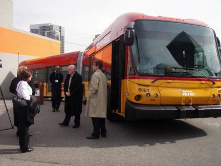
We didn’t want to bury this new information by adding it to our previous story about the city setting May 17 as the date for the permanent closure of the 1st Avenue South onramp to the westbound West Seattle Bridge – so here’s a breakout. We spoke with King County DOT‘s Linda Thielke a little while ago, and she said Metro does have the BUS detour worked out for the year and a half that there will be no way to get on the westbound West Seattle Bridge between I-5 and The Viaduct. First, the routes that will be affected:
21 local
22
56 local
57
116
118
119
Second, the detour route (we tried to make a custom Google Map but the line-drawing function is just not behaving for us, so that’s just going to have to wait): 1st Avenue South to Hanford (map), west on Hanford to East Marginal Way (map), south on East Marginal to Spokane (map), then across the lower bridge. Only one current stop, in the 1st/Spokane vicinity, will be missed, and this will only affect the “back to West Seattle from downtown” runs, since the 1st Avenue South offramp on the eastbound side will not be affected (also, the new 4th Avenue ramp on that side will open later this year). The one key piece of the puzzle that Metro is still working on: Travel times/scheduling, so they can create something resembling a predictable schedule for this detour. They’re talking with the city re: signal timing, for example. And Thielke pointed out one other thing: Metro also is trying to keep this all in the “big picture” – they can address what needs to happen because of this May closure, for example, but with all the other work scheduled in the area, they are trying to make sure things don’t have to change every time “another domino” falls. This domino – the 1st Ave. So. ramp closure – is part of the city’s Spokane Street Viaduct project; the official online info starts here.
If you use Highway 99 to commute past the Battery Street Tunnel, you’ll want to know about these lane closures coming up – read on:Read More
 For those closely watching the future of the South Park Bridge, particularly whether it will have to shut down this summer if the county can’t find money to replace it, three notes: First, an update from our citywide-news partners at the Seattle Times – while that story’s topline is “the bridge might have to close in June,” the real news in the story appears to be that the county’s awaiting study results which might show the bridge COULD be kept open. Meantime, we’ve learned of two meetings next week for those interested in the bridge’s future – both have been publicized in South Park, but apparently not in West Seattle: First one is Tuesday (March 9), 7 pm, during the regular meeting of the South Park Neighborhood Association. The county has sent out a mailer – see it here. Then on Wednesday (March 10), community advocates are organizing a meeting about the bridge; here’s info about that, from the South Park Yahoo! group.

That’s one of the sketches shown at the last meeting of the Alaskan Way Viaduct South Portal Working Group, which had asked for better visual representations of the new tunnel route as it crossed under the current viaduct and approached the seawall. When we covered the most recent meeting of this group – tasked with discussing and vetting plans for how traffic will be handled south of the viaduct’s Central Waterfront section — its next date hadn’t yet been set, but now it has: March 23, 4 pm, Puget Sound Regional Council board room (1011 Western Avenue). At the January meeting, it was promised that this meeting will include more on upcoming construction staging, as well as how various scenarios would affect biking, walking and transit times. The public’s welcome at these meetings; here’s a map to PSRC offices.

We’ve been tracking work on the new King County Water Taxi dock at Seacrest – next step, the gangway. Its components arrived at the end of the week, after the concrete dock was towed in (see our previous story/photos here) and secured. And you may soon see the new vessel on the West Seattle-downtown run, the Rachel Marie, because King County Transportation Marine Division communications manager Susan Whitmore says it’s being brought into Puget Sound this week, after leaving the Ballard shipyard where it’s been getting ready for its new role (see our “sneak peek inside tour” story here). Whitmore says the crew – county employees, now that the service is no longer operated by Argosy – starts work two weeks from tomorrow and will be training until the new season begins on April 5. 6:48 PM UPDATE: Seems the Rachel Marie didn’t wait till next week – we’re told it was seen out and about today, and Zack sent this photo of the RM docked at Pier 50 this evening, now sporting the KCWT branding, next to its counterpart Melissa Ann, which makes the Vashon-downtown run:

9:31 PM UPDATE: The explanation comes in comment and on our Facebook (WS Blog) page – the Rachel Marie will fill in on the Vashon-downtown run because of mechanical trouble that took the Melissa Ann out of service.
 According to Seattle Police via Twitter, there’s a multiple-car crash in the northbound Battery Street Tunnel, so the tunnel’s closed and drivers are being diverted off at Western Avenue, right before the tunnel. Also via Twitter, SDOT says a tow truck’s on site, so perhaps it won’t be closed too long. “No known injuries,” according to SPD. (Thanks to Nichole Taylor for the photo.) 3:20 PM UPDATE: SDOT has tweeted that the situation is cleared up – but one commenter with a view says the BACKUP isn’t clear yet.

That’s one of the new “no parking” signs just put up along eastbound Admiral Way, in front of the businesses on both sides of the Admiral/California intersection. The city was “considering” parking removal as of last fall, back when we had repeated reports/discussions here about traffic troubles at the intersection. Then today, via Twitter, Revolution Coffee and Art reported, “The parking on Admiral in front of Revolution is officially gone now – please don’t park there.” The signs went up today, Revolution confirms.

With a little over five weeks to go till the new season starts for the King County Water Taxi‘s West Seattle-Downtown Seattle run, construction of its new dock at Seacrest has entered the second phase. After the new pilings were finished earlier this month, the site was quiet for a while, but now the concrete dock itself is going in – the photo above is from about an hour ago. The first day of the new season is scheduled for Monday, April 5th; last Friday, we brought you a close-up sneak peek on board the boat King County has leased for the run, the Rachel Marie (see our story =here). It’s currently at a Ballard shipyard getting freshened up, with the county branding outside, and new seats (among other things) inside – this shot from our Friday tour looks toward the bow on the main deck:

You’re likely to see West Seattle’s new Water Taxi out on training runs starting in a week or two. Meantime, here’s a little more background about the new dock; other changes for the new season include fares and the downtown dock location, which moves south to Pier 50 (which the other county run, Vashon-Downtown, already uses). ADDED THURSDAY NIGHT: Thanks to Brenda C for photos taken as the concrete dock floated in, earlier in the day:


This has apparently been in beta a few weeks but we hadn’t heard about it till a mention on WSDOT‘s Twitter feed today: The Vessel Watch page, which tells you where any given state ferry is at any given moment, has been upgraded – the map used to be static, and now it’s dynamic, with panning/zooming capabilities among other things. Check it out here. (And while that feature can identify a state ferry for you, if you’re looking to ID any other kind of vessel, MarineTraffic.com’s the place to go.)
That’s according to Peter T, who added the update in the comment section of our Monday story. It’s been almost six weeks since the slide that narrowed the road (here’s our original report); the Department of Planning and Development says it’s working with an uphill property owner on a permanent solution.

From SDOT: Crews are working today in the 6000 block of Beach Drive SW, where a slide last month has left the road restricted to one lane. SDOT’s Marybeth Turner tells us, “They are clearing away slide material and will set ecology blocks along the side of the street. The goal is to reopen the street to two lanes (one lane in each direction).” We are checking on the other questions that remained unanswered regarding the slide situation – including plans for permanent stabilization. 2:57 PM UPDATE: Bryan Stevens from DPD has some information on the latter issue. He says they’re working with a property owner in the 6000 block of Atlas Place, over the slide:
The city is working with Mr. Saladino to quickly review an option that stabilizes the slope and protects the public.
At this point, we have not received a permit application from Mr. Saladino to stabilize the property. Mr. Saladino has not yet provided the city with a geotechnical report that provides sufficient information to evaluate the options and the appropriate design. Our engineers need this information for their review to assess whether the proposed options do indeed stabilize the slope and protect the public.
At this time, we are waiting for Mr. Saladino to respond to our request for additional information.
SDOT is taking advantage of the unseasonably dry weather to remove slope debris from the Beach Drive right-of-way and place a temporary ecology block catchment wall in the parking lane on Beach Drive. This work is underway and should take one to two days. Upon completion, SDOT will reopen Beach Drive to two-way traffic at this location.
5:56 PM UPDATE: SDOT now says the work will continue tomorrow (Tuesday) instead of taking a break till Wednesday.

Not many details on these incidents, but witnesses took the trouble to share photos (and the 911 log has the time/place info) – Above, Ed photographed the car fire that brought Engine 29 and crew to 60th and Admiral (map) just after 3 pm; no injuries, Ed says, and the car was eventually towed. Below — One week after the hit-run truck-vs-multiple-car crash along 35th SW north of Myrtle Reservoir, neighbors heard the crunch of a collision yet again, just after 6 tonight; this is described as a chain-reaction crash, no injuries:

Thanks to Jake for the photo. This was near 35th and Willow (map), south of the closest cross-street to last week’s crash, Holly.
(Updated at 6:10 pm after a conversation with the developer whose project’s at the heart of this)

ORIGINAL 4:37 PM REPORT: In the bright jacket, that’s West Seattle-dwelling City Councilmember Tom Rasmussen, who chairs the council’s Transportation Committee. Rasmussen bicycled up to Pigeon Point this afternoon to listen to neighbors’ concerns about effects of the 6-week road closure that starts on Monday so that a developer can run a sewer line to new-home sites on 23rd SW. First reported here 10 days ago, the closure not only will close a major route between North Delridge and Pigeon Point/Puget Ridge, it also will reroute Metro’s 125 bus (details here), which in turn means parking restrictions on nearby streets that are not in the construction zone. Most galling to neighbors – as noted here last night, when the signs went up yesterday, they covered an even longer stretch of nearby streets than had been announced by SDOT – and that’s what has neighbors most concerned. Jim S wrote in a WSB comment last night:
It’s frustrating to say the least. It feels very much as if the city has sold out Pigeon Point for a developer’s utility upgrade to the arterial. I understand that Riser Homes are paying the full ride on the sewer and storm drains on 23rd and that cost is considerable, but this has affected a far wider swath of neighborhoods than the average street closure. Closing virtually all parking on two of the three major streets in the Pigeon Point neighborhood without consulting the neighborhood is very unfair. It is a thoughtless, cookie cutter fix to a problem that required a more measured equitable solution.
This afternoon, Rasmussen met with about a dozen residents, coordinated on short notice by Pete Spalding (at right, below, with Rasmussen at left – note the “no parking” signs lining the road in the background).

It’s not just a matter of nowhere to park and driving a detour route, neighbors say, it’s also a safety issue – as hundreds of drivers detour, there’s concern they may go racing down streets where there’s not usually heavy traffic. And there’s a big-picture issue here: Notification. Everyone agrees that the homebuilder did what was required – notifying neighbors in the immediate area – but, as discussed at the Delridge Neighborhoods District Council meeting last Wednesday, what’s required, may not be enough. In our video clip, you’ll hear Rasmussen wonder if there’s any way to hold off the project now, so that a meeting can be held with neighbors first:
There was no public word of the impending closure till signs went up on Delridge a week and a half ago; the signs seemed to suggest Delridge was closing for six weeks; a WSB’er named Pete (not Spalding) contacted us to ask what we knew. We checked with SDOT, which explained the developer’s plan – this Feb. 10th story resulted – and got him to add “23rd SW” lettering to the closure signs; the information about bus and parking restrictions followed, and Pigeon Point neighborhood leaders have been working round the clock to try to make sure residents are getting accurate information. They’re expecting SDOT reps to be in the area to monitor the situation on Monday morning, first commute period after the closure is scheduled to happen, if the plan doesn’t change in the meantime. (We also have e-mailed the developer to ask for comment.)
ADDED 6:10 PM: Got a fast response from Jon Riser, the aforementioned developer, who called after receiving our e-mail. He says, “This is a process that’s been going on for a long time. We submitted a traffic control plan back in November – it’s not a small, little, quick, throw-out-a-permit thing to close the road. It’s been a drawn-out (process) that’s involved Metro, city engineers, and my own traffic engineers. This is the plan they came up with that they felt was the safest.” He says he’s talked with Councilmember Rasmussen and that holding off construction isn’t an option – “I don’t see us not starting on Monday” — Riser says this phase of the project will be costing him $10,000 a day; “the contractor’s lined up and this all has been rolling for weeks.” But, he adds: “What I do want to do is, during the first initial closure, try to adjust some of this …” such as, seeing if buses can “turn directly onto 21st,” and adjusting some of the no-parking zone on 23rd for residents who face “some serious parking problems.” He adds, “Adding signs, removing signs … whatever we can do in the first day or so. … (And) we’re trying to get a couple police officers to be on site to help. … I’m trying to do what I can.”
9:04 PM: Pigeon Point residents say the “no parking” warning signs are up but are stretching beyond the areas described in previous communication from SDOT. Neighborhood leaders are working to sort this out, and also hope to talk with city crew members expected to be in the area to check on the situation Monday morning.
EARLIER (ORIGINALLY POSTED 3:18 PM): We’ve been covering this for a week now, but in case you missed it, here’s the official reminder from SDOT of the North Delridge/Pigeon Point/Puget Ridge road closure/detour situation starting Monday – read on:Read More
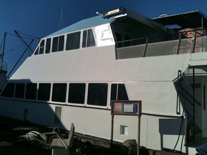
When you step on board the 77-foot catamaran Rachel Marie – which will make the West Seattle-Downtown Seattle run of the King County Water Taxi when this year’s service starts April 5 (new date) – you may feel a little smarter. That’s because the boat used to carry rocket scientists. True! As explained by Robert Patronsky of Four Seasons Marine, which owns the RM and its sister ship Melissa Ann – the Water Taxi for the Vashon-Downtown Seattle run – this one made shuttle runs in the Western Pacific for many years, to a US military missile-testing site. A photo inside the vessel is testimony to this:

So are signs in English and the Marshall Islands’ language, Marshallese.

More recently, the RM was on a foot-ferry passenger project in Honolulu. But we digress. The reason we asked the King County Ferry District for a sneak peek on board the Rachel Marie, which is currently at a Ballard shipyard, is because many WSB’ers asked for more details when we first reported on the Rachel Marie (with photos) last month. Ask, and we’ll do our best to make sure you receive. “Is there an outside deck?” some asked. Here it is – room for about 40 people topside, stern – a one-minute tour of where you can sit/stand outside:
There’s an inside deck upstairs, too – keep in mind, this eventually is meant to run year-round – and then, the main deck:
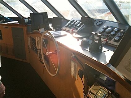
While the Rachel Marie is capable of carrying more than 200, Susan Whitmore with King County says it will be certified for up to 150 – any more, and they have different crewing and security requirements. Right now, they’re finishing hiring the crew – they’ve got their captains, who will be in a wheelhouse you can watch through windows at the front of the top interior deck:
Some other notes: No concessions; the county might look at that later as a revenue measure, says Whitmore, but nothing’s planned when the season starts. You can bring your own food/drink, though, and there are some tables in the main-deck seating.

(A few power outlets, too, if you just can’t stay off your laptop during the trip across the bay.) And as you probably noticed in the video clip, interior bike racks – enough to hold 18 total, no extra charge. Though the Rachel Marie has the ability to run faster than its predecessors, they’re keeping the same schedule for now – while looking for the “sweet spot” between fuel efficiency and speed. The basic fare is higher if you’re paying cash, as reported previously; Whitmore says they’ll keep taking cash “for a while,” but the farebox will be at the dock, along with an ORCA transit-card reader, and they hope eventually to install credit-card-capable ticket machines at the docks (remember, on the downtown side, they’ll be switching to Pier 50, just south of Colman Dock). Again, the new Water Taxi season starts April 5; that’s a Monday, so Whitmore says they’re not planning the kind of festivities with which they kicked off the season in past years, but might have an open house at some point. Meantime, the new dock at Seacrest needs to be finished – and then this summer, county leaders have to figure out the funding that’s needed for the service to run year-round as hoped.
King County Executive Dow Constantine says he’ll keep pushing for federal help to replace the South Park Bridge – which the county has said will have to close, , potentially as soon as this summer, if money can’t be found to keep it open. This, as word comes that the county did NOT get the “TIGER” grant (explained here) it was seeking (here’s a national overview on what DID get funded – locally, it included the city’s “Mercer Mess” $30 million request). We’re pursuing other details on this, but for starters, read on for Constantine’s statement (followed by, added 3:19 pm, Councilmember Jan Drago‘s statement):Read More
 Quick followup to last week’s reports/discussion about the closure of a section of 23rd SW southeast of Youngstown Arts Center, starting next Monday, related to nearby homebuilding. Many people wondered about the rerouting plan for Metro’s Route 125. Today we’ve received it from King County’s Rochelle Ogershok – it’s way too complicated to cut and paste here, so take a look at the PDF. She adds, “We will also be sending out an alert to Route 125 subscribers when the details are posted online” (sign up here for alerts) – and suggests anyone affected check the Metro website a day or two ahead of time, in case of last-minute revisions.
 To follow up on questions raised following our Wednesday afternoon report on the impending closure of a significant section of 23rd SW in North Delridge, we took them to SDOT‘s Marybeth Turner first thing this morning. She’s just replied with what you might call a fact sheet – read on to see it in its entirety (note the part about parking restrictions on other streets):Read More
 For the second consecutive week, West Seattle’s future RapidRide bus service resurfaced at a local community-group meeting. Last week, WSB’ers had a lot to say following our report on the Southwest District Council discussing a request to reopen the issue of its Triangle route. Today, a two-part update: First, the Fauntleroy Community Association got an update Tuesday night on how RR will travel through Fauntleroy. FCA is hoping to book a Metro rep for its March 23 all-membership meeting so that residents can take questions directly to the source.
Meantime, Susan Lantz-Day reported to the FCA board that Metro is still working on where RR will stop in relation to the ferry dock when it officially revs up in fall 2012, and addressing disability-access issues. The service, she says, will not lead to the addition of traffic lights in the area; a uniformed officer will still be on hand to direct traffic. The stops will use curb bulbs. FCA board members remain concerned about the east side of Fauntleroy, across from the dock, where the current bus shelter sits atop an access-challenged, taller-then-normal curb. Board president Bruce Butterfield said it’ll be vital for them to reiterate these concerns to the Metro at next month’s gathering (watch fauntleroy.net for more details). Now, part 2: We talked with Metro deputy general manager Victor Obeso re: some of the questions raised after last week’s RapidRide report – read on for our summary of that conversation:Read More
Got a note this morning from Pete M, who wondered about a sign (photo added 5:57 pm) he had seen while heading north on Delridge near SW Alaska (map) – he thought it suggested a big closure ahead, and wondered if we’d heard anything. We in turn checked with SDOT, whose Marybeth Turner has been investigating. She reports back that there IS a closure ahead, but not what the sign apparently implied:
A contractor for a private developer installed a misleading sign on Delridge Way SW. He is taking it down, and will replace it with a more accurate sign that indicates that SW Oregon Street (which turns into 23rd Ave SW) [map] will be closed. The developer is extending a sewer line for new homes.
Traffic going to South Seattle Community College coming from the north will be detoured to Delridge Way SW. The closure will start at approximately 9 a.m. on Feb 22 and is expected to reopen by Apr 5 (six weeks).
At Delridge, SW Oregon Street (which turns into 23rd SW) will be closed to all traffic. At the other end, 22nd SW (which turns into 23rd SW) will be closed to through traffic where 22nd SW meets 21st SW. 23rd will be closed to all traffic (including local) where it meets 22nd SW (this would be SW Alaska if Alaska cut through at this location).
Hope that all makes sense to area residents. She also included a word of thanks for the heads-up on the sign – so we’ve passed that on to Pete.
| 24 COMMENTS