Orchard Street Ravine: New plan, old idea – $ “wasted”?

orchardtent.jpg

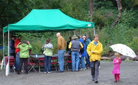
(photo courtesy Scott C)
Shortly after that photo was taken, more than a dozen people sat down under that canopy at Orchard Street Ravine on Saturday morning – subsequently besieged by rain and wind – to hear city Parks Department managers unveil a new proposal for the 38th SW “connector” into the ravine – and some were aghast. Previously, the department was looking at building a stairway into the ravine along what is technically 38th Ave SW right-of-way – now, suddenly, it’s proposing a simpler trail instead. What galled many of the people who gathered to hear about this was the amount of money, and time, spent to get to a point that some consider being almost back at square one. Read on:

orchardstrav.jpg

First, a little backstory. If you’re not familiar with Orchard Street Ravine, lostdogonline.com summarizes it well: “… a 2.2 acre site comprised of two Parks-owned parcels of land separated by an unimproved street right-of-way (38th Ave SW), with another unimproved right-of-way (SW Orchard St.) bordering the northeast side of the site also included in the greenspace,” also noting: “The forest type found at Orchard St. is one that is fairly scarce in Seattle – data reveals that only 52 acres out of 2700 acres of Seattle’s urban forest in Parks ownership that was surveyed contains the conifer-madrone forest that is present …” Ultimately, it’s envisioned that this area, and access through it, can enable people to make their way through the “Green Crescent,” from Myrtle Reservoir’s future park land, all the way to the shores of Puget Sound.

In the project that Saturday’s meeting — which came long after other meetings in 2006 and 2007 — focused on, the 38th right-of-way was the focus, leading from this street end on 38th south of Myrtle above the ravine (map):

38thend.jpg

Now, back to Saturday morning’s community meeting, held exactly one week before Mayor Nickels is scheduled to visit the ravine as part of a Parks-organized dedication/celebration (noon-2 pm next Saturday):

parkfour.jpg

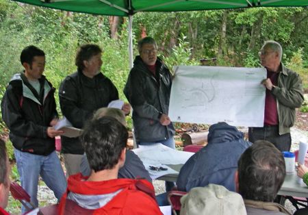
Under the canopy, those four Parks Department reps offered a lot of verbal sword-falling. Left to right, Michael Shiosaki, landscape architect/project manager Joe Neiford, Kevin Stoops, and landscape architect Ted Holden. Said Stoops, “We want to stop the bleeding in the design process.” That would be financial bleeding – according to a budget/cost summary sheet handed out, the city has spent more than $70,000 — more than half the project’s budget — over the past two years, trying to design the difficult-to-engineer staircase that’s now being scrapped in favor of a 3-foot-wide compacted, crushed gravel walkway, with some “stairs” made from landscaping timber and gravel, described as a “low-tech approach we can build fairly quickly,” with labor provided by Seattle Conservation Corps, and a bench along the way. Stoops described it as involving some “site disturbance, not a large-scale intrusion.” Here’s the plan shown at the meeting (click for a larger version):

orch.jpg

By meeting’s end, attendees were generally supportive of the plan, but critical of the time and money wasted to reach this point. The Parks Department reps laid some blame at the feet of the previous Parks administration (this all began well before current superintendent Tim Gallagher took the reins, and there has been a lot of internal turnover on the Orchard Street Ravine project too). Almost exactly two years ago, in fact — October 10, 2006 — then-Superintendent Ken Bounds issued a letter settling on the route of the connector and acknowledging community controversy. But subsequently, the trouble moved on to what would be done along that route, more than the route itself: “Part of the problem is that whoever came up with the project budgeted it badly,” Neiford said on Saturday, and since it was impossible to build stairs that worked within that budget – he talked about a difficult process of trying to solve problems caused in turn by solutions to previous problems – “we tried to make a square peg fit a round hole.”

Apologies weren’t enough for some attendees, such as John Nuler, who had been trying for months to get updates from the city, and said at Saturday’s meeting, “Why has there been such a revolving door? Where are the people who got us here? Three years later, nothing’s happened, our money’s been spent. I’m outraged; we’ve been cheated.”

Another attendee was similarly aghast. “We’re pushing $90,000 (in project spending, counting other expenditures) for just some drawings?”

Vlad Oustimovitch sounded a note of recap and regret: “In some ways, we’re really at the beginning. In an early meeting (years ago), I suggested a trail just like this, and said it could be done for less than $50,000, and the people who were on the project then just laughed at me. The community erupted into a divisive battle. Now, money’s been wasted. I prefer this plan (the trail) to a stairway … (but) I have an issue with the amount of money that’s been thrown over the transom.”

Not only is construction of the pathway needed, Oustimovitch said, but so is community “healing.” Cindi Barker of the Morgan Community Association turned to the crowd to suggest consensus, and didn’t get anyone expressing opposition to the new plan. The meeting ended with the Parks Department offering a “guarantee” that the trail will be built in the next “four or five weeks,” though some attendees suggested that if the weather turns horrific or other factors intrude, they wouldn’t want to see the city rush the project just in an effort to get some kind of closure. Parks reps say this plan for the connector will leave some money left for more restoration work in the ravine, which like many of West Seattle’s greenspaces is plagued by invasives.

The city also promised the neighbors would get regular updates from hereon out; you can check the project website at www.seattle.gov/parks/ProParks/projects/orchardStRavine.htm (if you received a postcard about Saturday’s celebration/dedication event — again, it’s noon-2 pm — you’ll note the Web address is a bit different, but Parks says this is the accurate one).

12 Replies to "Orchard Street Ravine: New plan, old idea - $ "wasted"?"

  • old timer October 6, 2008 (7:22 pm)

    Well, what a surprise?
    $90K for drawings – sounds about right.
    Vlad’s original plan accepted?
    Sounds good.

    Maybe the way to do the next project is for the neighborhood to go to the city with a site specific project proposal and get funding rather than process.

    Remember this experience the next time
    you vote ‘YES’ on a parks levy.

  • JimmyG October 6, 2008 (7:37 pm)

    Why would I vote yes for a parks levy when this is how they act as stewards of our parks and money?

    And turning the wonderful open green space/pocket park in N. Admiral into an area with playground equipment?

    No thanks, our votes will be no on the levy.

  • WSB October 6, 2008 (8:02 pm)

    For what it’s worth, since you bring it up, that’s in the section of my notes on the cutting-room floor – One person said the whole experience would sour them on voting for the parks levy; another person said, look at it another way, if not for the last levy (Pro Parks money involved in purchasing the Orchard Street Ravine land), “this would all be condos.”

  • J October 6, 2008 (9:53 pm)

    Hmm. This story has me waiting for the other shoe to drop on the Dakota substation park project. Another community that’s devoted hours and raised dollars for a park, which was supposed to be finished in summer of 2006, and, most lately, May 2008, and languishes still. Are they about to get another “oh, dear, we budgeted wrong–guess we’ll go back to square one”?

  • WSB October 6, 2008 (10:58 pm)

    Actually I do have some info on that in my inbox waiting to get written up … tomorrow … provided by Councilmember Rasmussen’s staff. Thanks for the reminder.

  • John Nuler October 6, 2008 (11:15 pm)

    A little history. After getting the city to purchase this site, purchase supporters immediately neighboring the property began encroaching, illegally cutting trees, storing motor homes & vehicles, building walls and structures in the city’s property and allowing the whole property to become overgrown with invasive plants.
    The Orchard Street Ravine was a mess until some well connected adjacent property owners realized that there was $175,000 up for grabs from the Parks Levy.
    The Parks Dept.Levy description states: “This project, part of the 2000 Parks Levy, develops trails to access ravine.” Although natural area restoration is not mentioned in this statement, it is discussed as a key element in all neighborhood planning documents that supported this Levy project, and was reaffirmed as a key element through the planning process.” – Parks Dept. Web Site.
    At the first community meeting stacked with a secret group that had had preliminary discussions with park personel, the NIMBY flags were raised. Because of crime, safety, property values, access, lack of facilities, parking, infrastructure etc. this group supported only “natural area restoration” despite the wording of the levy. They stood up at meeting and ridiculed the “concept” of the “Green Crescent”. Parks D. employees at that meeting Kevin Krauthamel, Karen Galt and Ted Holden claimed that Seattle’s Critical Areas Codes prohibited a trail on such slopes. After the meeting Kevin expressed to me his pleasure that no one wanted a trail. The next day, I phoned Kevin who then expressed his dismay that “the Levy wording requires a trail”. When this info got out the same group along with Parks figured a way to access the $175,000 by constructing their own Trail to Nowhere. This is the pathetic Loop Trail now complete for this weeks opening. It loops through the only portion of the ravine that has been cleared of invasives.
    Although “natural area restoration” is apparently where our money has gone, it has only restored the portion desirable to the NIMBY group. Much discussion at the meetings concerned clearing invasives from the hillside. Parks arborist Mark Mead talked at length about a machine called a Spider to clear the hillsides. Now Parks is saying that the hills will not be restored although that is still listed by them as a top priority. Indeed the new through trail is proposed to be cut through an eight foot wide tunnel of blackberries with no restoration.
    After members of the community at large, not just those immediate neighbors of the city’s land, got up to speed we formed our own open group and complained to Parks. This led to Ken Bounds, then Parks’ head and reputedly former neighbor of the NIMBY group’s organizer, to set aside another $140,000 for a through trail as worded by the levy.
    This in turn led to a through trail feasibility study that contradicted Parks’ claims. Unfortunately, “garbage in- garbage out” the primary criteria for this trail was, “Foremost among the criteria we provided was that the chosen
    option should have minimal impact on the land.” This criteria must have been designed to eliminate the communities’ preferred trail route. Which it did. Now Parks is eager to go ahead with a trail they have always claimed was not possible and one that does not have “minimal impact on the land”. On Saturday, Parks confirmed that they still were working off of a discredited LIDAR topo survey and have not done any soils tests as required by DPD Critical Areas Code.
    A trail through the park could provide exceptional views and an organic route to the Myrtle Park above. It could be used by families with kids at Gatewood. This new “hail mary” trail offers none of that and should be an embarasment to its designers.
    WSB reports that I “had been trying for months to get updates from the city”. True partially, I contacted Joe Neiford last May, July, August and September by e-mail and phone to get updates. He provided updates claiming in May that the design was 99% complete and construction would be starting in a few weeks. He made similar less believable claims all summer long. I even wrote asking why the city has a honeybucket at the stair site that has had no use for six months @$100 per month.
    He also assured me that park boundaries would be delineated with signage. Now read the handout from Parks received at Saturday’s meeting – “Survey markers were installed at most lot corners adjacent to Parks property…However, many of those survey markers have been removed by persons unknown…Addressing property encroachments onto Parks property is not part of the trails project.” This appears to be an invitation to encroachment.
    On WSB we often see NIMBY issues around parks – opposition to skateboards, play areas, lights and facilities. But never have I come across a group of NIMBYs as successful as in the Orchard Street Ravine. They have managed to acquire a park for themselves surrounded by an inpenetrable thicket of blackberries all the while consuming several hundreds of thousands of our tax dollars.
    Please do come to the Mayor’s grand opening this weekend to see for yourself where our $300,000 went and why this process has been a disgrace to the community. And maybe speculate on just who might be once again expanding their backyards through disappearing survey markers. Also please note the Alamo like masonry wall that is in the middle of 38th Ave right of way, yes the property line is between the wall and the house, hence the “extreme lack of parking” for the event.

  • homesweethome October 7, 2008 (2:48 pm)

    Parks levy funds currently have nothing to do with a new playscape in Admiral – and please reference coverage of this proposed park improvement and note that the proposed enhancements do not include play equipment.

  • TWAR October 7, 2008 (9:49 pm)

    Jimmy G. I will not vote for the parks levy either. Being a North Admiral resident, I am dealing with the California Place Park issue mentioned above. Friends and Neighbors of North Admiral are like a Piranha on the neighborhood. There is a huge contingency that does not want any change to the park. But the FANNA group just puts on that Prozak look and keep moving forward. Like we do not exist. Oh by the way the Neighborhood matching funds come right out of the General fund. Bypassing the ailling Parks Department.

  • Michael Wald October 11, 2008 (9:44 am)

    Part of the increased cost of the project was undoubtedly due to the effort on the part of the Parks Dept. to satisfy and reconcile the various suggestions received from neighbors who attended the planning meetings. At the very first meeting two attendees made the conspiracy charges when their ideas for the park were not wholeheartedly accepted by others attending the meeting. If the meeting was”stacked with a secret group”, it was not apparent to me. Could it be that I was part of the “stacked secret group” and no one told me that I was a member?

    I have been a volunteer worker at the park for quite a while and I am not sure that I have ever seen any of the people complaining about the project at any work Saturday.

  • draw October 12, 2008 (1:13 pm)

    I, too am not voting for the new park levy! Colifornia Place Park proponents will be asking for far more money than is available through the matching fund. They will in the future be asking for opportunity funds in the new levy to transform this Park to conform to their private vision. You heard it here first!!

  • john nuler October 14, 2008 (3:20 pm)

    Michael Wald knows if he was a member of the “stacked secret group” by whether he attended or was even notified of that “stacked secret group”‘s meeting/s before that “very first meeting”. I was not one of “two attendees (who) made the conspiracy charges when their ideas for the park were not wholeheartedly accepted by others attending the meeting.” I did not speak at that meeting. I approached Kevin Krauthamel only after the meeting in which he pushed for restoration only and claimed a trail was impossible and not required by the Levy. He was wrong.

  • Lisa Carey October 24, 2008 (11:17 am)

    I believe that the only way to get any attention about my concerns about the access to my land at the top of the park is to see a lawyer. The trail along side our driveway is not acceptable. and the proposed gravel they wish to put at the bottom of it will make coming and going a hazard at best. We have used this access for over 60 years and need someone to take us seriously. I am concerned for the safety of pedestrians as well as the safety of our driving down the road.

Sorry, comment time is over.