LIGHT RAIL: ‘Pigeon Ridge,’ ‘Oregon Street’ concepts survive Sound Transit Stakeholder Advisory Group’s Level 1 review

By Tracy Record
West Seattle Blog editor

They’ve been working for months on a light-rail extension we won’t see for years, but had just minutes to decide which rough-draft alternative concepts should move forward and which shouldn’t.

That’s how it went last night during the Sound Transit West Seattle/Ballard light-rail extension Stakeholder Advisory Group meeting at ST’s downtown boardroom.

The process already has been billed as hurried so that the 2030 target for opening West Seattle’s ST3-decreed line can be met or maybe even exceeded, but this stop along the route was the most rushed of all we’ve covered so far.

The meeting had begun with facilitator Diane Adams telling the group (see its membership here) being told, “Tonight you won’t need to make a ‘preferred alternative’ determination,” followed by ST executive Cathal Ridge adding, “We would at least like to make some progress down that road.”

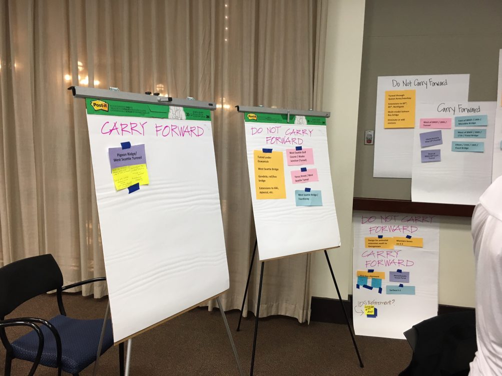
That they did – but with little time for detailed deliberation. Here’s the bottom line for the West Seattle segment, after the tables’ discussion toward night’s end:

Sorry for the fuzzy image – the checklist slide was created on the spot, so there’s no digital version, but here’s the pre-yay/nay version of the same list so you can read and compare:

And here are the maps from last week showing details on each:

Here’s how those decisions were reached (again, the group had to decide yay/nays on the other parts of the West Seattle/Ballard extensions too, but for obvious reasons, we are mostly just reporting WS details):

The SAG members were broken into four tables as they had been one week earlier, and they were given materials focused on the roughed-out alternatives that were shown at that meeting, as well as an explanation of why some of them were described as having less potential than others. The West Seattle alternatives were used as an example here. You can see that toward the start of the meeting’s full slide deck (also viewable here in PDF):

The ST explanation also singled out the concept of consolidating or eliminating a station as “potentially not consistent in the ST Plan.” Ridge suggested “the easiest part of the meeting” should be deciding whether any of the least-practical (as identified by ST) suggestions should be carried forward. And as for the ones identified with “more potential,” the question to address, “How might these alternatives be refined?”

And then the table discussion began, roughly 15 minutes for discussion of each segment after a brief recap by a ST staffer, this time moving east to west, Ballard/Interbay, then Downtown, then SODO, then West Seattle.

WEST SEATTLE SUMMARY: Before the tables bit into the West Seattle possibilities, ST’s Stephen Mak provided an overview of the alternatives that debuted at last week’s meeting, shaped by what ST had called the “themes” they noted in the “early scoping” public comment phase:

He also showed again the slide showing how they all shook out in evaluation (see above), calling out the “golf course” option as “performing similar to” the original draft alignment (route). But, he said, that one has the “section 4f” challenge, and would eliminate the Avalon station. The eventual summary, as noted above, was that the Pigeon Ridge and Oregon Street alternatives could move on. The table where we were listening in had some extra notes about the former:

… but had barely seconds to discuss the latter, as the groups had been instructed to move from bottom (ruling out the “less potential” alternatives) to top (vetting the “more potential” ones) and Oregon was last; the table we were observing had just gotten to it when discussion was shut off.

Around the room, there was a bit of disagreement on whether to carry forward the option that would have involved the West Seattle Golf Course – one table suggested a “hybrid” that might include some elements of it. Ridge said he had listened in on the discussion and the positive element seemed to be going into a Junction-bound tunnel from the golf course area, so perhaps that could be a modification (or “refinement” as potential changes had been labeled at the start of the night).

Two tables said that for SW Alaska and SW Oregon, they’d like to see elevated and tunnel versions for a comparison. Some participants voiced concerns about port impacts and how to minimize them.

Concerns were also voiced about whether SAG members had enough information to fully rule some options out or in – this in particular emerged in reference to a mention of U.S. Coast Guard policies and how they related to possible north-end options. Ridge said he agreed they need to explain better why certain things “don’t work.”

In case you’re interested, we took a couple notes from the other segments, and photos too:

SUMMARIZING BALLARD/INTERBAY: Everyone agreed not to carry forward the “not practical recommendations” except one table thought “the multimodal bridge should be studied” and that it is too soon to “shut down” that conversation. Ridge said that they really wanted to move forward what the ST3 funding would cover and if other modes were going to be involved, they’d have to understand “where the money would come from.” One lady said it feels “fake” that the alternatives identified as having “more potential” aren’t even “up for discussion.” Ridge said they ARE open to some discussion if there’s a strong observation about one of those. Another group member, in discussing another possible alternative, said he felt they don’t have enough information right now to fully evaluate possibilities. Another person noted that “it’s hard to discard anything” because one currently defined alternative might be good for Ballard and not for Interbay, or the other way around.

DOWNTOWN NOTE: Two tables disagreed with the suggestion that a First Hill station would be inconsistent with ST3. Among those arguing in favor of it, former Mayor Greg Nickels, who noted that it was part of the Sound Move plan, and that First Hill is a major job and residential center. Otherwise, the two butterscotch-shaded “not practical” suggestions were unanimously deemed “don’t carry forward” by all four groups.

SODO NOTE: All tables agreed not to carry forward the idea of “design for potential extension south to Georgetown.” One table disagreed with everyone else agreeing that the idea of a “First Avenue alignment” shouldn’t carry forward. One person observed that the SODO plan doesn’t really serve SODO, but is more laid out to serve people transferring through SODO.

WHAT’S NEXT: The West Seattle “neighborhood forum” is your next chance for comment – 10 am-12:30 pm Saturday, May 5, at the Masonic Center (4736 40th SW). Then the Elected Leadership Group has its second meeting on May 17th. Ridge says the results of last night’s meeting will go to that group, and by the time the stakeholders meet again May 30th, they’ll be on to talking about “what our alternatives are” for Level 2 of screening, to “start this process all over again.” Final decision, though, is in the hands of the Sound Transit Board, which is expected to choose a “preferred alternative” by spring 2019.

27 Replies to "LIGHT RAIL: 'Pigeon Ridge,' 'Oregon Street' concepts survive Sound Transit Stakeholder Advisory Group's Level 1 review"

  • NRV April 25, 2018 (2:26 pm)

    What’s the point of having a neighborhood meeting when the neighborhood is not being listened? Deeply disappointed by this process.

    • Jort April 25, 2018 (3:32 pm)

      Probably because neighborhood associations aren’t always the best at planning complex, multi-billion dollar transit systems?

      I believe that the neighborhood was listened to quite well back when your neighbors voted overwhelmingly in favor of light rail to West Seattle.

    • Peter April 25, 2018 (3:50 pm)

      In what way is the neighborhood not listened to? Keeping in mind, not getting your way does not in any way mean the neighborhood is “not being listened” to. People who prefer a different option than you also get input.

    • Joe Szilagyi April 25, 2018 (6:07 pm)
      “What’s the point of having a neighborhood meeting when the neighborhood is not being listened?”
      Neighborhood meetings are self-selectedd (who bothered to physically show up) and absolutely are not entitled to or supposed to have any more clout as a percentage of the total feedback than anyone else. 
      You showed up and said your piece.
      I couldn’t from conflicts so I mailed my piece in.
      Both our pieces are absolutely even and only like 0.000001% of the total decision.
      I adore how involved we all get but a lot of us need to get a grip.
  • Wseattleite April 25, 2018 (2:37 pm)

    Quick question:  Are these now the only two options that are on the table at all for implementation, or the only two options that are eligible for the advisory groups recommendation to the powers that be?

    • WSB April 25, 2018 (3:31 pm)

      Theoretically, neither – theoretically, something else could be recommended. In practice, having watched the process at every meeting and public event so far … your latter seems more likely. And then, since the Elected Leadership Group takes this group’s recommendations under advisement, they COULD just come up with something else entirely … and in turn, since the final decision is up to the ST Board, they COULD ignore everything recommended to them and make their own decision. Since the “neighborhood forums” began before yesterday’s meeting, the ones that have happened already (West Seattle’s is still a week and a half away) happened without knowing that the stakeholders had their say on Level 1 yays and nays, so I’m going to try to find out how last night’s recommendations will play into what happens at the West Seattle forum – TR

      • Wseattleite April 25, 2018 (9:48 pm)

        Thank you WSB for your input. You provide a valuable service to those of us with little time to really research. 

  • sam-c April 25, 2018 (2:48 pm)

    Hmm, interesting. Tough choice narrowing those down, but it seems like they picked the ‘best’ two, in my opinion.  Unfortunate though, that the remaining option with (2) tunnels also had included the caveat that third party funding may be required, providing an easier excuse to toss that one aside? I don’t know…

    • chemist April 25, 2018 (3:43 pm)

      or maybe they trim that pigeon ridge plan down to one tunnel and follow the route all the others take north to avoid the previously mentioned “in-water work at superfund site” issue.

  • Dakota Andover April 25, 2018 (3:38 pm)

    I mentioned this in earlier threads, but I’ll post similar thoughts keeping mind the ST scoring system and the latest comments from the SAG meeting regarding the various options.  Hopefully a hybrid of the plans can be developed using some of the best attributes of the various routes, so here’s my humble opinion. The ST scoring system appears to give a reduced or downgraded score to the options that run along the north side of the bridge coming over the Duwamish and my guess is the first tunnel of the Pigeon Ridge route would get a reduced score for the costs and Superfund site issues, so that leaves the Baseline and West Seattle golf course (light blue) alignment as the most likely cost effective option for the Delridge Station area portion of the route. I think the Golf Course alignment putting the Delridge Station more to the south makes sense over the baseline representative route location closer to the bridge. They’ve mentioned the USDOT Section 4(f) regulatory issues as a problem for going through the golf course outlined in the Golf Course route, so I’d proposed heading west on Genesee, but rather than cut the corner and tear down all those houses as the baseline representative alignment shows, push that radiused turn a little further south so that the tracks go over the Delridge Park skate park and then gradually swing back along Genesee to run along the edge of the golf course where it could then enter a tunnel portal just before Avalon Ave. where the Golden Tee apts. are.  A tunnel portal there also allows the elevated portion along Genesee to be standard height and barely change elevation to hit the portal at the mid-point of the hill, rather than the 150-foot plus needed to climb up and over the hill.


    The Avalon-Junction tunnel options seem to be getting some attention with ST, so the alignment from there could follow their option outlined in the second tunnel of the Pigeon Ridge route from Avalon to the Junction.


    By combing the general Delridge Station area alignment of the representative route with the attributes of the tunnel from Avalon to the Junction, you could reduce the added costs of the proposed first Pigeon Ridge tunnel, but keep the benefits from the second proposed tunnel section.

  • Peter April 25, 2018 (3:57 pm)

    Viva Avalon station!

    After the first round, Oregon/44th clearly stood out as the best option for serving the area, accommodating future expansion, and not breaking the budget with tunnels. I’m happy it made the cut. This option provides the best location for the Delridge station and keeps Avalon, and thus provides the best services and highest potential ridership. It’s a win/win/win option (best access/cost/growth). Of course there will be some tweaks and modifications, who can see the future, but this is a great starting point for more specific planning.

    • KM April 25, 2018 (4:31 pm)

      I used to be really on board with the tunnel (and removing the Avalon station to do so), but I’ve though more about it and these two options are both pretty great. It’s nice to see how the’ve worked to incorporate feedback and open up to other ideas.

  • Jackie April 25, 2018 (5:13 pm)

    Why is the light rail only being built on the North end of West Seattle? That area is already in close proximity to shops and restaurants. I understand the need to connect to downtown, but South West Seattle is going through a development boom, plus with the annex of White Center. I would argue people in this area are in need of public transit more than people who can afford housing near the Junction. Was this suggested by anyone? 

    • Peter April 25, 2018 (5:46 pm)

      The ST3 initiative approved by us, the voters, was for light rail to the Junction. Going farther south is outside the scope of ST3 because frankly everything cannotbe done all at once. However, we the community have made it clear that a design that accommodates future expansion is important, and these two options reflect that. 

    • Joe Szilagyi April 25, 2018 (6:12 pm)

      Where is southwest West Seattle getting a development boom? Single family homes here and there getting subdivided into 2 and 3 homes on a lot isn’t a boom. There’s no new major density going up in places where it should like Morgan Junction and Westwood, or spreading out from the cores of those areas. The boom is from the Junction east along Alaska. What we have down here in the SW is paltry and sleepy compared to that. Once 35th and Roxbury and Morgan and California look like 15th NW and Market and 41st and Alaska, we’ll be booming.

  • TJ April 25, 2018 (5:41 pm)

    Doesn’t sound like annexing White Center is in the works from what I thought. At least it shouldn’t be. From a cost benefit analysis I don’t see the benefit of annexing. Unless Seattle immediately upzoned there and gave developers the same give aways as here to drive up property values and spread out this development. As for the location of light rail, I would argue that where it is planned now has more tax dollars going towards it so they should be rewarded

  • M.B. April 25, 2018 (9:17 pm)

    White Center hasn’t yet been annexed. More importantly a lot of us don’t WANT to be annexed.

  • Nick April 26, 2018 (1:00 am)

    It will be annexed eventually, the county pretty much mandated that it needs to be incorporated if I’m not mistaken. The question is just when… Although I haven’t heard much about that lately.

  • ACG April 26, 2018 (9:11 am)

    So, on the Oregon plan, did they say what would happen to the homes, apartment buildings (AJ, Oregon 42),  churches (Hope Lutheran and Eastridge) and businesses (bowling alley, senior center) on Oregon?  Oregon is not a very wide street to send light rail up. Would those structures be torn down to create room for light rail?

    • WSB April 26, 2018 (9:20 am)

      None of the “alternatives” are down to specifics.

  • Busser April 26, 2018 (10:08 am)

    I think that Oregon plan makes a lot of sense, because then the station would be right next to the major bus hub. Makes transfers a lot easier.

  • Keith April 26, 2018 (11:15 am)

    Oregon/44th might look good on paper, but when you actually consider those particular streets and try to visualize an elevated line running up/through them (and potentially displacing/impacting many existing businesses, services, and homes) it doesn’t make sense at all. 

    • BUSSER April 27, 2018 (1:45 pm)

      There will unfortunately be displacement wherever the final line ends up.

  • Jeff April 26, 2018 (10:47 pm)

    I’ve been to all but 1 of these SAG meetings. Sound Transit spent the first handful of meetings indoctrinating the group. Then last night, the leadership were pushing the group to cut as many alternatives as possible. One of the SAG members even spoke up during a couple of the leadership’s overviews to state that she felt the SAG is being bullied by Sound Transit meeting leaders into cutting alternatives too early.

    But then, those early indoctrination sessions worked out in the end.

    Listening in on the discussions of those sheep, everyone was in a frenzy to eliminate as many alternatives as possible, just as Sound Transit wanted. Very few discussions on tweaks to the alternatives so they could be carried on and thought on further.

    Our local West Seattle neighborhood “representative” in the group stated during their group discussion that he didn’t want the Delridge Station down under the bridge. That’s not convenient for him. So that option is out. No group discussion on tweaks to that alternative (Dark Blue line on map). No mention of how that alternative wouldn’t have negatively affected the already bottleneck at Delridge Way entrance onto West Seattle Bridge. No mention of how that route would save tax payers millions of dollars by not having to steal/buyout local housing. Nor any mention of how that route doesn’t displace commuters that can use that Delridge station.

    Our local “representatives” also canned the Golf Course route (light blue line on map) with extreme fervour. The alternative was drawn up with a huge wide turn over the entire Delridge Playfield. You’d think, hey, let’s shorten that arch, similar to how tight the arches are that all other the options take, move it a hair farther south, and it’ll miss the Playfield and Community Center entirely. Nope. That one never had a chance. (For some reason, even at the mention of “4f review” everyone cringed in fear).

    And the route down wide Andover street, which also would prevent displacement of families/commuters, while providing a station that could meet the needs of both the North Delridge area and the Avalon area, yet also reducing the incline (in comparison to the ultra-steep Genessee hill)? Gone. No talk of any sorts on that one. If we really need 3 stations, not 2 (which we don’t since 1/4 of Avalon station is served by Delridge, 1/4 is served by Junction, and another 1/4 serves a golf course, where no one lives), it would’ve been nice if someone would have mentioned placing Delridge station (on this pink line on the map) near Subway restaurant and scooting the station shown on the map just a hair west to serve that remaining 1/4 of people in Avalon area.

    Overall, I’m mightily disappointed in our Stakeholder “Advisory” Group. Being made up mostly of large corporations (Amazon, Expedia, Nucor, and an ex-mayor, to state a few), mixed with meek sheep they can mold into their opinions, the SAG clearly does not have any neighborhood’s best interests at heart, and definitely not the Delridge neighborhood.

  • Dustin April 27, 2018 (10:15 am)
    I’m glad that these conversations are continuing and hope that Sound Transit will take feedback from the community seriously throughout the planning process. I think it’s important to remember that:
    -An expanded light rail system would be an asset to the city as a whole: everyone benefits, directly or indirectly, from this work
    -The finalized alignment will not be able to accommodate every preference: people in WS will need to make some concessions and eventually compromise on a final plan if we want to move the project forward
    -This is by all indications a long range project and no one currently in WS will be taking the light rail to get downtown in the short term: taking the extra time and money to incorporate community feedback and make smart engineering and urban planning decisions while setting this alignment will make the results of this project better for the future residents of WS and others in the city who may need to come here
    -Yes, tunnels are expensive and changing the plan will cause a delay, but concerns from the Junction businesses about impacts on the neighborhood are not frivolous. Take a look at the elevated track under construction at the Northgate Transit Center to get a sense of what a rail station directly over the Junction might look like. WS residents should be willing to consider raising money for a tunnel improvement as a benefit to our neighborhoods, or at least carefully consider where an elevated track should be placed.
    -The votes for ST3 were likely more in support of the expansion of the light rail system than acceptance of a “promise” that ST will deliver a specific engineering result. We should be skeptical of anyone pushing to rush the planning process or dismiss legitimate community feedback with an excuse that people voted “overwhelmingly” for ST3: we don’t really know what aspects of the plan unique voters are willing to compromise on, and this can only be determined by ST by actually communicating with groups of residents and listening to their feedback through panels, messages, comments, surveys – all comments and avenues of communication matter, regardless of ST’s preferred process or politics
    I haven’t been able to attend any of the community meetings in person, but it’s exciting to follow updates and contemplate what’s possible – thanks to WSB for covering these forums and keeping us informed!
  • Deb April 28, 2018 (3:42 pm)

    Are the two proposed Oregon Street and Pigeon Ridge routes above ground or include tunnels along Genesse?  Don’t see any modification to the original impact to residents along the Genesse and Avalon intersection.  Please clarify. 

Sorry, comment time is over.