By Tracy Record
West Seattle Blog editor
One final community meeting to recap from this past week – here’s what happened as the Southwest District Council discussed three transportation-related projects – including issues such as Fauntleroy Boulevard construction vs. Sound Transit 3 planning – and received a crime-trends update.
NEIGHBORHOOD STREET FUND PROJECTS: SDOT outreach lead Natalie Graves said she was there to “take feedback” as the project leads weren’t available. West Seattle’s projects were two of 12 chosen for funding in this round of the every-three-years Neighborhood Street Fund proposal/selection/construction process.
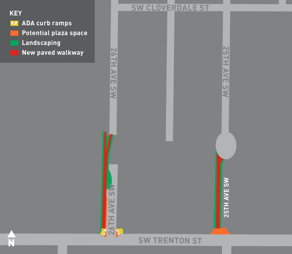
First, Graves showed photos of 25th and 26th where the Chief Sealth IHS Walkways Improvement project will be built – currently, trashed, tangled pathways north of SW Trenton. Two 10-foot-wide paved walkways are proposed to improve those pathways, along with lighting and landscaping, and possibly a “plaza” space at 25th and Trenton. They asked for community feedback last month and have heard many “positive” things so far, Graves said. In particular, they’re still looking for ideas for that possible plaza space – seating? Play area? “Place for arts”? “Places for group activities”? Or? A CSIHS PTSA rep asked how people would get from the walkway to Westwood Village – is a new crosswalk planned? Short answer: No. (There’s already one by the stairs that come down from Southwest Athletic Complex.)

Second, the Harbor/Spokane (Avalon/Manning) intersection project. Graves showed its visibility challenges as well as the striping confusion/disrepair where Manning empties onto Avalon. There’s some restriping planned there, as well as a curb bulb on the northeast corner of Harbor/Spokane and creating a bike-only signal and bike lane across the 30th/Harbor/Spokane intersection “to give (bicyclist) a head start.” The jersey barrier near that corner will be replaced by steel railing and “overgrown vegetation” in the area will be trimmed back. A no-right-turn-on-red signal is planned too. She clarified that parking removal on Avalon is NOT planned as part of this project but the repaving for 2019 might be looking at street markings that could have “parking (as part of) the conversation.” (We had noted in our previous update that the newest project map, above, was a change from a previous version that had mentioned possible parking removal.) And she confirmed that SDOT has been talking with Luna Park merchants who are particularly concerned about that. The project lead plans to do outreach for start in spring and summer. A variety of questions and concerns emerged in feedback and Graves will be taking them back.
Both projects are due for construction next year, and the project team will come back to the community this summer when design is further along.
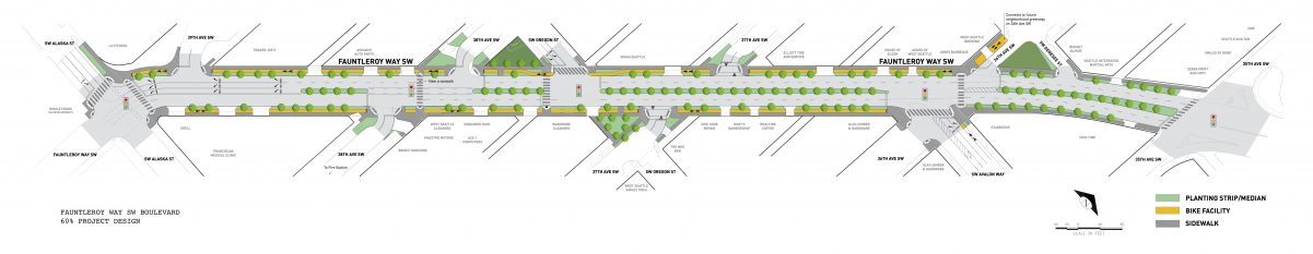
FAUNTLEROY WAY BOULEVARD: Sharonn Meeks, a community advocate and former SWDC co-chair who has been long involved with the project, offered something of a defense of this project, explaining that “this is about the gateway to Seattle.” She said that when she first became involved, she thought it might take “two or three years … now, 18 years later, I think the situation has changed, and I don’t think the existing Fauntleroy roadway is adequate, appealing, safe to walk, or for that matter to drive on. Over the past 18 years there have been literally hundreds of hours of meeting, outreach, neighborhood walks, council meetings, many compromises … (but) we felt we needed to respond to community needs in the Triangle Plan, the Bicycle Master Plan, improve the mobility by organizing the streets more predictabl(y), and enhance Fauntleroy Way’s role as it enters into our community and the peninsula. It’s the entry into the entire peninsula.” She cited features such as new sidewalks, crosswalks, shortening the crossings, realigning some “skewedup intersections,” new street lighting, protected bike lanes, signal additions and some revisions to get traffic moving through there, landscaping, urban design features, some public art – which we’re required to have – and just maintaining the freight and car mobility through there.”
Meeks noted that she participated in the two walking tours and was happy with “really, really good” participation. Feedback continues to this date. (Scroll down the project page for contact info so you can send your comments.) This project will be at 90 percent design this month, Meeks said, and “there is an ongoing traffic study … to be completed by the middle of April.” She says she knows that Councilmember Lisa Herbold is working to put together another meeting with businesses and residents and SDOT, after being the one who pushed the mayor across the final line to get funding for the project. (The meeting to which Meeks referred on Wednesday night is likely this meeting announced Thursday, the Fauntleroy Way Neighborhood and Business Association‘s second meeting, April 19th.) “The construction period is going to be inconvenient, but it’s not a deal killer – we’ll get through this,” Meeks added. “I’m not a traffic engineer or an architect but I’m just trying to get this little project done.”
At that point, Pete Spalding, representing the West Seattle Chamber of Commerce, said the organization has asked SDOT to review not just the traffic study that was originally done in 2014, and at some of the projects that have since been added/proposed for the area. Meeks then noted that the Chamber, West Seattle Transportation Coalition, and other organizations had signed off on a letter a while back supporting the project. Spalding said the Chamber wants another look at the two right-hand-turn pockets that might get removed, how traffic to/from the YMCA will be dealt with, and that it’s asking the Office of Economic Development to start on its mitigation plan now, rather than waiting until construction late this year or early next.
Ellen West from the Junction Neighborhood Organization said that she had brought up the Sound Transit 3 issue – that the plan for light-rail stations here would be just a few years behind this project – on one of the walking tours. She said she was told that a tunnel was out of the question for getting light rail into The Junction, but Meeks and Spalding begged to differ.
Andra Kranzler from Councilmember Herbold’s office at that point said the official answer on Sound Transit was that final location decisions hadn’t be made and construction is not scheduled until 2030; planning for all the Seattle light-rail stations is scheduled to start in 2023. She read this message from Office of Planning and Community Development director Sam Assefa, addressing points that had come up in community discussions:
§ OPCD is currently reviewing its approach to station area planning associated with ST3 throughout the city. They fully intend to engage with the West Seattle community around the potential for urban design, development, and investments in the walkshed around the future light rail stations. Final Sound Transit decisions have not been made about the final alignment and station locations at north Delridge, 35th and Avalon and the Alaska Junction. It is premature for the City to begin detailed planning until we know more information about the West Seattle alignment.
§ In addition, the three West Seattle stations are not scheduled for construction until 2030. Historically, we are aware that the private real estate market begins to respond to fixed rail and station investments several years in advance of the beginning of service. We plan to begin planning for all Seattle light rail station areas by 2023. We may have resources to begin conceptual planning in advance of that date.
§ OPCD notes that the City undertook a two-year process for the West Seattle Triangle that concluded in 2011. This planning effort included an Urban Design Framework (UDF) document, limited rezones, streetscape concept plans, planning for pedestrian amenities, investments for a new park location, and preliminary design work for the Fauntleroy Boulevard. At the time, members of the community did not wish to undertake planning beyond the boundaries of the West Seattle Triangle planning area.
§ The City’s planning work in Ballard was not undertaken for purposes of light rail planning. At the time, several factors combined to make detailed and coordinated planning in Ballard possible, including advance work by both residential and business communities, an allocation of funding to coordinate transportation planning associated with Bus RapidRide provided by the previous administration, and the fact that Ballard was one of two aggressively growing communities (second only to the Pike Pine neighborhood).
§ Another recent example is the University District UDF published in 2013—eight years prior to the anticipated station opening—in cooperation with residents, the business community and social service providers. Planning was undertaken in response to the region’s investment in light rail and the need for broad stakeholder involvement around future major institution planning for the University of Washington in a very high density neighborhood. Other light rail station areas in SE Seattle were the subject of planning closer to the beginning of light rail service.
§ Comprehensive Plan policy C 2.3 provides criteria when selecting neighborhoods for community planning activities. We will consider the West Seattle Junction Hub Urban Village and other neighborhoods as we consider where we will invest our limited planning resources in the coming years. We may provide you with a complete list of neighborhoods that have engaged with the City around planning for light rail and for various other reasons if you are interested in.
POLICE UPDATE: From Southwest Precinct Operations Lt. Ron Smith: Around the SWDC area – western West Seattle – year to date vs. one year ago – “crimes against persons” are down 16 percent (including robberies); property crimes are up one percent (including arson); residential burglaries down 22 percent, commercial burglaries up 31 percent (that includes storage-unit breakins – the precinct is working with major local storage facilities on improving security). As he had mentioned at another recent meeting, they’re working with local merchants on reducing shoplifting; they comprise about half the incidents in the “larceny” category of theft, which is up by about a third around the peninsula. Car prowls are down 17 percent, but “the biggest concern we have right now is … auto theft has been skyrocketing in the area.” 63 in the past month – about two a day – “we’ve made some big arrests, but …” The cars don’t go to chop shops; they get stolen, and dumped. There’s no pattern – north, south, west, east, it’s happening everywhere (as you know if you read our Crime Watch reports). “No rhyme or reason to this, except to use (the stolen car) for the commission of a crime – they’ll steal a car, drive around and see a vehicle that looks like it, and steal (that vehicle’s) plates.
Asked about RV camping in neighborhoods, Lt. Smith referred questions/concerns to Officer Todd Wiebke, who remains the precinct’s point person on homelessness-related issues (todd.wiebke@seattle.gov).
JUNCTION NEIGHBORHOOD ORGANIZATION UPDATES: JuNO director René Commons had updates from the previous night’s meeting of her group with city reps, including that $1.98 million is budgeted for the 2/3-acre park on 40th SW, where the temporary fire station is now, and planning for it is scheduled to start this summer. City staffers acknowledged to JuNO that there is a green-space gap in the Junction area – some non-open facilities such as the West Seattle Golf Course had previously been factored in. The Parks Department noted that it will keep watch for acquisition possibilities. The Junction Association and JuNO took a walk earlier this week with City Light at night to make note of lighting challenges; watch for outreach there.
HELP FOR A HUB: Ellen West from JuNO said she’s stepping out of her role with the West Seattle Emergency Communication Hubs‘ new Junction hub (outside Hope Lutheran at 42nd SW and SW Oregon), for which she’s been a co-captain – it’s not time-intensive but it’s potentially life-saving, and it mostly requires availability for drills.
MORGAN COMMUNITY ASSOCIATION: Its April meeting is coming up, Wednesday, April 19th, said Tamsen Spengler. (Watch morganjunction.org for the agenda.)
The Southwest District Council meets first Wednesdays most months, 6:30 pm, at the Sisson Building/Senior Center, 4217 SW Oregon. All welcome.
| 4 COMMENTS