HIGHLAND PARK WAY SLIDE: PM updates; road expected to remain closed ‘through Thursday’

(TOPLINE: Highland Park Way hill will be closed “through Thursday” per SDOT)


(WSB photos: First two taken ~12:30 pm)

1:14 PM: SDOT now says the Highland Park Way hill is likely to remain closed at least “into tomorrow.” That’s the newest development in connection with the early-morning slide that shut down the busy road between West Marginal Way SW and SW Holden.

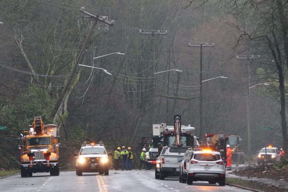
Here’s our morning report (thanks again to everyone who texted us when it all began around 5 am); we just went back to the top of the hill for another look, and as you can see in our photo above, there’s lots of activity. Here’s the newest information from SDOT spokesperson Sue Romero:

SDOT continues to work with Seattle City Light at the site of the slide that occurred on Highland Park Way SW. A slide came down this morning above Highland Park Way SW, then a second slide came down, pushing material about 500 feet further, over Highland Park Way SW.

SDOT has cleared some of the material from the lower slide so SCL trucks can gain access. SCL is working to clear some trees that are pushing on some power poles. Geotech engineers are assessing the situation.

We expect Highland Park Way to remain closed through today and into tomorrow as more rain is expected to fall tonight into tomorrow.

Meantime, the power outage caused by the slides, which peaked at more than 2,000 homes/businesses, is over for all but two customers, according to City Light’s outage map, which also has been fixed.

We’ll be updating this story throughout the afternoon, including any related traffic advisories for the pm commute – again, expect Highland Park Way to remain closed TFN, and plan your alternate route and travel time accordingly.

3:13 PM: Bus reminder: “Metro Route 131 continues to be rerouted off of a portion of Highland Park Way SW between SW Holden St and West Marginal Way SW, until further notice.Use the stops on Highland Park Way SW south of SW Holden St or east of West Marginal Way SW.”

Whichever route you plan to use to get home, be aware that the heavy rain has continued this afternoon, lots of water on the roads, so be patient. The WSB Traffic page has cameras for various routes, and you also can check the video feeds accessible from the lower right of the city Travelers’ Information map – browse the feeds on the West Seattle and Greater Duwamish pulldown options.

3:47 PM: We asked City Light’s Scott Thomsen for the assessment of how the slide had affected their installations along HP Way: “The slide toppled some trees. At least one went into the lines, causing the outage. We didn’t lose any poles, but some are leaning over. We plan to monitor the hillside to make sure it has stabilized before we reset the poles. We might have to install some small retaining walls to protect the poles.”

7:04 PM: SDOT just tweeted that Highland Park Way is expected to remain “closed through Thursday.” So DEFINITELY plan morning options, and we’ll track the status during the day.

And the National Weather Service says this is the seventh-wettest February on record.

9:40 PM: Still closed. We checked the top of the hill again after leaving a nearby meeting about half an hour ago; no lights visible down the hill, so crews apparently had quit work for the night. We will start morning traffic coverage extra early tomorrow (5 am Thursday) because the road will still be closed.

THURSDAY MORNING: Our AM updates are here through at least 9 am.

30 Replies to "HIGHLAND PARK WAY SLIDE: PM updates; road expected to remain closed 'through Thursday'"

  • M February 15, 2017 (2:02 pm)

    Maybe they can fix the light at Roxbury so that diverted traffic isn’t so horrible tomorrow. 

    • WSB February 15, 2017 (2:04 pm)

      The outage there is over so it should be working again – have you gone through it in the past hour or so? If so, please call SDOT – 206-684-ROAD to report…

      • K February 16, 2017 (6:35 am)

        Traffic has been backed up on Highland Park Drive to where it meets Thistle street because only a few cars can make it through the left hand turn on Roxbury per cycle. There’s no left turn arrow. They really need someone directing traffic until they get Highland Park clear. It’s a mess and took me 30 mins to get from my house to the highway when it normally takes me 5.

  • Trickycoolj February 15, 2017 (2:15 pm)

    It was noted in the previous thread by a different commenter, write the city council Transportation committee to let them know what an important corridor this is and that the ongoing safety concerns are not acceptable. I can only imagine how bad this would have been had it happened at 5pm with bumper to bumper cars in the uphill lanes. 

  • zephyr February 15, 2017 (4:09 pm)

    This is the route I usually take to reach I-5 South (i.e. Highland Park Way to 599).  Tomorrow I am headed to Tacoma.  I really don’t want to drive across the West Seattle Bridge at 8:30 in the morning to access I-5.  So I am thinking of trying to reach 518 near SeaTac by way of Ambaum.  I don’t know if I could find my way through the tangle of Roxbury and the other streets to access 599, my normal route.  Any other ideas?  Thanks.  

    • WSB February 15, 2017 (4:13 pm)

      Z – when we have to go to I-5 South, we take Roxbury to Olson to 509 to Burien, turn left and head past Sea-Tac to I-5 (which connect near Southcenter).

      • STEPHEN SESTRICH February 16, 2017 (12:57 pm)

        That was a mess yesterday too. I’d just go through White Center and Burien via Delridge and Ambaum. In fact, since I work at the airport that’s what I’m going to do.

    • datamuse February 15, 2017 (5:11 pm)

      Either do as WSB suggests, or go east on Roxbury to the left turn on 1st, then immediately exit to 509 north. Follow the ramp and stay in the lane as it becomes exit only, turn right, and you’re on 99/509 as usual.

      • datamuse February 15, 2017 (11:25 pm)

        …that was supposed to be 99/599. You get the idea.

    • KJ February 15, 2017 (5:25 pm)

      You could take Avalon or Delridge to under the bridge and then West Marginal and back to the bottom of the hill to meet up with 599.

      • Helihu February 16, 2017 (10:34 am)

        That’s what Waze sometimes tells me to do, but I have been too chicken, especially when the low bridge light is flashing. 

      • STEPHEN SESTRICH February 16, 2017 (1:02 pm)

        I couldn’t even get near the approaches to the bridge. Traffic on Delridge and Avalon was backed up for a mile at least. All the arterials in Highland Park were parking lots and people were picking their way through side streets like I was.

  • RC February 15, 2017 (4:10 pm)

    I’m also writing KC Council Rep. McDermott about bus service. There was not any notice provided when the 131 was rerouted this morning, and I know people who waited more than an hour. I am going to request that bus service be expanded for other routes if the 131 remains rerouted past tomorrow. The 125 and 120 are already packed during rush hour, and can’t handle any more riders.

    • Michelle February 15, 2017 (10:35 pm)

      6:05 pm Wed

      131 NB has been rerouted

      we no longer have to walk to 8th&99th

      it turns off Highland Park Drive, L down Holden, and loops back up to Roxbury to make its way toward Georgetown 

      metro didn’t bother updating the Alert on their website, I found out only after the 25 min walk that it had been unnecessary 

      it’s annoying enough we have to stand in the rain with no shelters at many stops, the bustimes are notoriously off by often 20min, but no signage on a reroute and can’t even be bothered with a webpage edit, come on Seattle, this is a world class city!

  • Mark February 15, 2017 (4:17 pm)

    Zephyr no one wants to drive (park) on the west seattle bridge in the am, it sucks.  Hopefully they can get HPW opene soon maybe use the 2 downhill lanes temporarily with one uphill and the other downhill

  • BlairJ February 15, 2017 (5:03 pm)

    Zephyr,

    This morning I took Roxbury to Olson Place and stayed in the left lane as it curved onto northbound 1st Ave S and then onto Cloverdale,  took a right in South Park onto 14th and then joined 99/599 from there.  Worked pretty well before 7:00 AM.

  • trickycoolj February 15, 2017 (5:34 pm)

    The frustrating thing is that Google Maps hasn’t recognized the road closure so of course it keeps telling me it’s a 12 minute drive to home/work with “minimal” traffic.  And then I map via the high bridge and get a 30+ minute route and 2 extra miles.

    • Theresa February 15, 2017 (9:54 pm)

      I was using the Waze app today and it knew about the closure.  It’s worth giving that a try.  

  • fiz February 15, 2017 (5:39 pm)

    Ambaum turn left at 128th, onto 509  ramp, all the way to the end, under the SeaTac runways,  and down the hill to I-5.    My office is in Kent.  This is always my route of .choice.  

  • zephyr February 15, 2017 (5:52 pm)

    Wow.  These are great alternatives.  I will study the map a bit and choose one.  And I will also write the others down for future reference.  Thanks, all!  (As for the Roxbury ones, I thought it was reported that Roxbury was clogged with a traffic light problem.)  

    • WSB February 15, 2017 (6:05 pm)

      Power outage affected Rox this am but that’s long over.

    • Rockhills February 15, 2017 (8:17 pm)

      Zephyr, this AM Roxbury/Myers/Olson were all backed up at around 8:30.  You always have the option to go straight down 16th Ave.  which turns into Ambaum and is a major arterial,  and turn left on either 128th st. (goes to 509) or 148th (runs you right on to 518).  This AM, my fastest route was to turn around and get the heck off of Olson, then take 4th Ave. straight south to 128th. 

  • M February 15, 2017 (6:46 pm)

    I noticed today that there is a new, fairly large pothole by the curb going down Admiral right below where those 100 trees were cut.  There was a lot of water flowing from the hillside into that pothole.  It also looks like a few smaller trees have fallen further up Admiral Way.  I wonder if SDOT is monitoring the high risk slide areas as it appears some more trees are leaning a little bit more.

  • Hoku February 15, 2017 (7:26 pm)

    M: please report your concerns to SDOT. Given all of the recent landslides onto public right-of-ways SDOT may not be aware of what’s happening in that area.

    • M February 15, 2017 (9:20 pm)

      I left a message at emergency land management.  Hopefully they are the right ones to call.

  • zephyr February 15, 2017 (8:15 pm)

    Quote KJ:  You could take Avalon or Delridge to under the bridge and then West
    Marginal and back to the bottom of the hill to meet up with 599.

    You know.  I actually considered that but I am unfamiliar with the traffic pattern down  under the bridge past Avalon.  I wondered if I would get caught up in some gridlock.  I know that when I come down HP Way in the mornings, I see a lot of big truck traffic headed north that way as I cross the West Marginal Way intersection.  ‘Also thought that it may be more traveled than usual due to the slide.  Plus I think I better head south than north since I live in Gatewood.  Thanks. I am studying maps now. 

  • zephyr February 15, 2017 (9:37 pm)

    Thanks everyone who suggested alternate routes.  I think  I will go down and get onto Ambaum and thence to 509 via 128th as KJ and Rockhills suggested.  

    .

  • Kay K February 16, 2017 (8:23 am)

    Thought this historic image of a slide on Highland Park Way on April 9, 1935 from the Seattle Municipal Archives might be of interest (this hill has been on the move for years):

  • HoldenOn February 16, 2017 (11:15 am)

    Great Job – West Seattle Blog!

    Any updates on when the HPW might reopen?

Sorry, comment time is over.