AS-IT-HAPPENED COVERAGE: SDOT-led walking tour of 35th SW

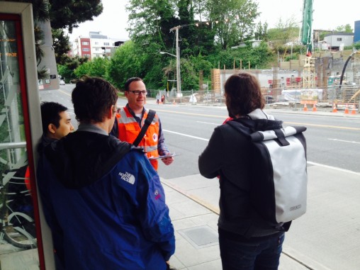
FIRST REPORT, 9:36 AM: As of just after 9 am, the SDOT-organized walking tour of the 35th SW Safety Project zone is under way. Above, project manager Jim Curtin, who started the tour with one assistant and three members of the public. At the outbound 35th/Avalon RapidRide, he explained that the section of 35th in that area is NOT proposed for rechannelization or other major changes. He was asked how the mixed-use development across the street will change conditions in that area:

Curtin mentioned, as has been reported here, that it includes a slopeside stairway to help connect the 35th/Avalon area (which is the gateway to West Seattle Stadium, WS Golf Course, and Camp Long) with the growing residential/business area to the west in The Triangle and The Junction. The transit stop, currently relocated to the south, will be “improved,” he said. Then after a few minutes, the group headed southbound, where we spotted them a few minutes later outside the stadium entrance:

You can catch up with the tour for a moment, an hour, whatever interests you. The stops and times are listed here, continuing until they reach 35th/Roxbury at noon. And if you don’t get to catch up with any of this – Curtin reiterated at the start that SDOT will come back to the community with the next version of the proposal, next month. You can send comments/observations/questions to him at jim.curtin@seattle.gov.

11:07 AM: We checked in on the walking tour again at 35th and Morgan, one spot where SDOT had said during the recent community meetings that they were still deciding what would be best to do to avoid significantly delaying traffic here:

Curtin said the plan for this intersection so far includes “tweaking the signal phasing.” Nearby residents who joined in at this stop mentioned parking near the intersection that could be reviewed for removal.

P.S. We’ve been experimenting with the new Twitter-linked “live” app Periscope lately and went live at this stop for a few minutes – if you use Twitter, check it out (or, if you don’t want to use Twitter but do decide to use the Periscope app, just follow us there!).

12:22 PM: The tour concluded right on time – we stopped by to check in as they arrived at 35th and Roxbury:

Curtin told the final few participants that “Option A” is looking the most promising, especially “south of Oregon,” and that the community meeting will likely be in mid-June.

10 Replies to "AS-IT-HAPPENED COVERAGE: SDOT-led walking tour of 35th SW"

  • sam-c May 16, 2015 (2:49 pm)

    considering 35th is such a hot button issue for so many commenters here on WSB, I am surprised more people didn’t show up.

  • MOVE Seattle May 16, 2015 (9:10 pm)

    Before road dieting 35th to one lane and lowering the speed limit to 30, maybe SDOT could figure out how to conduct a live test for a few week days….see how traffic flows during a test run and get feedback from those who used 35th during the test. Jim Curtain- any thoughts?

  • jwright May 16, 2015 (10:06 pm)

    I cannot imagine how a test run over a three-mile stretch of road could possibly work. Contemporary traffic modeling software + experience from previous projects (like Delridge and Fauntleroy) probably gives them a very accurate idea what the result would be.

  • RachaelB May 17, 2015 (7:01 am)

    Nobody showed up because they conducted a walk when everyone was at work and couldn’t attend.

  • ChefJoe May 17, 2015 (1:12 pm)

    Yep RachaelB, few people support these plans so they didn’t show up at 9AM Saturday for this. All the “everyone else is making my city unsafe” people were busy getting their kayaks ready.

    • WSB May 17, 2015 (1:48 pm)

      It wasn’t a “show of support” walking tour, it was a “here’s the latest and what do you think about it?” walking tour. The people who did show up – who were there for the three stops during which we dropped in, inbetween covering other events – actually asked questions and offered ideas. Like it or not, the world is run by those who show up, as they say, and in this case, the city is actually trying a bunch of different ways to get input, and if this way doesn’t work for you either, maybe you’ll consider letting them know what would – or maybe you’ve already e-mailed to say that. (again, project manager is jim.curtin@seattle.gov) Anyone interested in being heard could have shown up for five minutes at any one of the stops along the way, which we had mentioned a couple times in advance (and they did actually stay on time). Perhaps they did, between the three stops we chose (at the start, roughly the middle, and the end). – TR

  • Bob Neel May 18, 2015 (4:18 am)

    With the considerable resistance to the proposals presented so far (see earlier posts re: the Change.org petition), I’m disappointed that SDOT hasn’t concluded, “We need to consider an ‘Option C’ that addresses safety without re-channeling, and get public input on THAT.” I believe it would be very favorably received.

  • sam-c May 18, 2015 (9:03 am)

    wait, was the walking tour on Friday or Saturday? I thought it was Saturday?

    • WSB May 18, 2015 (9:20 am)

      Yes, it was Saturday. Please see date on story … we published these reports as it was happening Sat. morning.

  • RayK May 18, 2015 (2:04 pm)

    Jim and James who accompanied Jim offered a steady commentary on the physical road conditions as well as proposed traffic channelization changes. I support the changes.
    I was also disappointed at the turnout on a Saturday morning. One resident walked the entire route (thank you John). Perhaps the Roxbury walkabout will be better attended by neighbors Wednesday evening?
    Again, thank you Tracy for your multi-tasking coverage of the story.

Sorry, comment time is over.